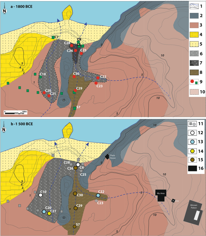
Figure 3.
The wetland of Malia before (a: 1800 years BCE) and after (b: 1500 years BCE) the Bronze Age eruption of the Santorini volcano. A- 1. Hypothetical coastal line (blue) and contour line (grey, 1 m eq., elevation indicated for 1–5 m and 10 m contour lines). 2 Cretaceous limestone (Sidheropetra); 3. Pleistocene deposits; 4. Pleistocene Calcarenite; 5. Beach barrier sand; 6. Sandy marshy deposits; 7. Silt to silty-clay organic sedimentation: marshy deposits. The dark grey applet on (a) corresponds to the limit of the marsh deposits c. 5000 BCE; 8. Light brown silt: colluvial and fluvial deposits; 9. Core drillings 2015 (red dot) and ante 2015 (green square); 10. Main excavated area of the Minoan town of Malia. (b) Evidence of tsunami impact; 11. No clear evidence of tsunami impact; 12. Sharp sedimentary erosional contact; 13. Layer with allochtonous microfaunal marine fossils; 14. Tsunami deposits; 15. Post-tsunami continental sedimentation. 16. Minoan buildings cited in the text including the Minoan palace with its central court (white rectangle). Edited in Adobe Illustrator CS6 2020 version 16.0.

