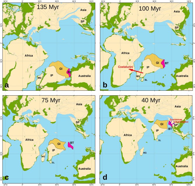
Figure 7.
Proposed scenarios of tectonic evolution of the Indian Plate and Burma Terrane with respect to our time-calibrated phylogenetic reconstruction and statistical biogeographic models for the freshwater mussel subfamily Parreysiinae (see Fig. 2 for detail). The paleo-maps are as follows: (a) Early Cretaceous (135 Myr): unionid mussels have gone extinct in continental Africa but survived on an East Gondwanan fragment containing the Indian Plate (with Greater India) and Burma Terrane, where the first split in the Parreysiinae did occur, i.e. the separation of the Lamellidentini; (b) mid-Cretaceous (100 Myr): colonization event of the Coelaturini MRCA (red arrow) to continental Africa, suggesting direct contact between the Indian Subcontinent and African Plate, probably through Madagascar; the Indian Plate and Burma Terrane are still connected through the Greater India; (c) Late Cretaceous (75 Myr): final separation of the Burma Terrane from the Indian Plate, probably by a partial submergence of the Greater India; both the landmasses served as insular “biotic ferries”, carrying Gondwanan biota to Asia; and (d) Late Eocene (40 Myr): Burma Terrane—Asia collision, leading to the expansion of the Mekong’s Indochinellini MRCA to the Sundaland Subregion and a colonization event of the Pseudodon and Yaukthwa MRCAs (Gonideinae: Pseudodontini and Contradentini)23 to the Burma Terrane (purple arrows). IP Indian Plate, BT Burma Terrane, GI Greater India, SP Sunda Plate (with the Indochina Block and Sibumasu Terrane), SL Sri Lanka, MG Madagascar. Color filling is as follows: Burma Terrane (pink), Greater India (light orange), modern land (light yellow), proposed ancient land (light green), and ocean surface (light blue). The paleo-maps were created using GPlates v. 2.3 (https://www.gplates.org)205 and corresponding data sets206–209, with additional modifications according to a set of novel tectonic and paleomagnetic models39–42,48,137,139 and our biogeographic reconstructions. (Maps: Mikhail Yu. Gofarov and Ivan N. Bolotov).

