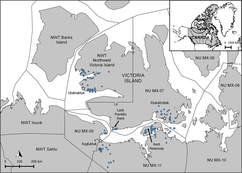
Figure 1.

Map showing the muskox management units (MMUs) in the NWT and NU and the five specific geographical locations from which samples were obtained [communities of Ulukhaktok, Kugluktuk and Ekaluktutiak (black and white stars), and Lady Franklin Point and Kent Peninsula (black arrows)], with the geo-referenced harvesting locations of the muskoxen when available (blue points). Geographic coordinates were unavailable for 15 of the 211 muskoxen; these animals were assigned to a specific geographical location based on the MMUs in which they were harvested and on the community from which the kit was submitted (Ekaluktutiak, n = 8; Kugluktuk, n = 2; Ulukhaktok, n = 3; Kent Peninsula, n = 2). Map generated in QGIS version 2.8.9 using the shapefile from Cuyler et al., 2020b. For the purposes of the analyses, animals from Ekaluktutiak, Lady Franklin Point and Ulukhaktok were grouped within the broad geographical location of Victoria Island, which is only divided into two MMUs because of political boundaries. Animals harvested near Kugluktuk (NU MX-09 and west part of NU MX-11) and on the Kent Peninsula (east part of NU MX-11) were treated as two separate broad geographical locations (i.e. west and east mainland, respectively), because of ecological and muskox health status differences (Leclerc, 2014; Walker et al., 2005).
