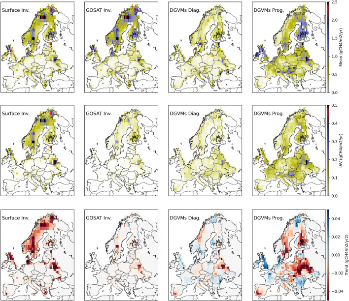
Fig. 1.
Comparison of mean, variability and trends of wetland CH4 emissions in the RECCAP2 Europe region simulated by top-down and bottom-up approaches in 2010–2017. The three rows show the spatial patterns of wetland CH4 emissions (fWet) based on the datasets from the Global Methane Budget 2000–2017 [81]: an ensemble of 10 in-situ and 11 satellite-based atmospheric inversions (left column) and two simulations by an ensemble of 13DGVMs: one using prescribed wetland extent from the WAD2M datasets (DGVMs Diag., all 13 models, centre column) and another with prognostically simulated wetland extent (DGVMs Prog., only 8 out of 13 models, right column). The top row shows mean annual fluxes, the second row shows inter-annual variability in annual fluxes and the bottom row shows trends in the mean annual fluxes (red for negative trends, indicating reduced emissions, and blue for positive trends, indicating increased emissions). Inversions and DGVMs agree on fWet sources to be mostly located in Scandinavia, Denmark and northern UK but the magnitude of fWet is consistently lower in DGVMs. DGVM runs using prescribed wetland extent (DGVMDiag) show consistent spatial distribution with inversions, while simulations using prognostic wetland extent (DGVMProg) show strong sources in parts of eastern and central Europe. Interannual variability (second row) in inversion datasets is highest in northern and Eastern Europe, while for DGVMs, IAV patterns are more uniform across the whole region and higher for DGVMProg. There is wide disagreement between the four datasets for the trends in 2010–2017 (bottom row). More detailed information about the datasets and model simulations is provided in Additional file 1

