Supporting information for Fisher et al. (2003) Proc. Natl. Acad. Sci. USA, 10.1073/pnas.0630493100

Fig. 9.
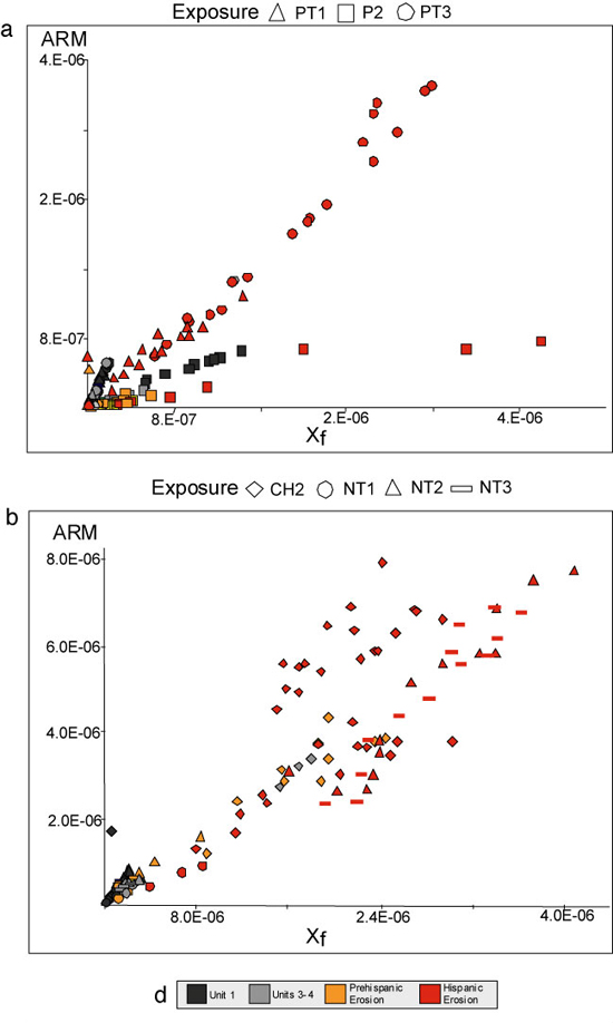
Examples of variation in mineral magnetic variables related to the source and type of eroded material deposited on the lake bed. Exposure locations are shown in Fig. 1a. Symbols at the top designate exposure. Distance from origin indicates an increase in concentration while the slope of a regression line increases with a decrease in the grain size of magnetic minerals. (a) Scatterplot of ARM vs. Xf for exposures below the Prehispanic site of Charahuén near the modern village of Nocutzepo. This site is located on a clay-rich luvisol (Charanda; see discussion of parent materials Supporting Text) common throughout the Lake Basin. Lithostratigraphic units 1–4 (Prehispanic shown in gray and orange) cluster near the origin, whereas unit 5 (especially exposures PT1 and PT3) (Hispanic shown in red) forms a linear scatter trending away from the origin with a steeper slope than Units 1–4 indicating increasing inputs of fine-grained topsoil (Charanda). The very high magnetite or maghemite concentration of Unit 5 may indicate erosion of unconsolidated volcanic parent material. (b) Scatterplot of ARM vs. Xf for exposures below the Prehispanic site of Pareo near the modern village of San Bartolo Pareo. This site is located on uplifted weakly magnetic diatomite (Uirás; see discussion of parent materials in Supporting Text) common at the lake margin in the study area, and typically yielding ARM values < 2.0E-07 for Units 1–4. Units 2–4 (shown in orange) received variable inputs of Uirás colluvium throughout the Prehispanic period. Lithostratigraphic units 1, 3, and 4 (shown in gray) cluster near the point of origin, whereas Unit 5 (Hispanic shown in red) form a linear scatter trending away from the origin indicating increasing inputs of upland sedimentation. In this instance, it is the Charanda luvisol common on the upper slopes of the lake basin but not found at the Prehispanic site of Pareo. Exposure P2 (square) is located at the lake margin and the low ARM values (<2.0E-07) may indicate periods of in situ diatomite formation. (d) Legend shows lithostratigraphic units.