We read with interest the study by Pullabhotla et al. (1) that sought to quantify the global impact of exposure to biomass burning on infant mortality from 2004 to 2018. They used the FireCCILT11 monthly burned area (BA) product that was derived using Advanced Very High Resolution Radiometer (AVHRR) satellite data at 0.05° and 0.25° resolution (2). The AVHRR sensors were not designed for BA mapping and of some concern is the impact of known FireCCILT11 product flaws (3, 4) and another product flaw found based on our examination of Pullabhotla et al.’s findings. Unless the effects of these flaws on their analysis are shown to be negligible, the veracity of their findings is questionable. This is unfortunate, as inappropriate use of FireCCILT11 has detracted from another potentially impactful study (5).
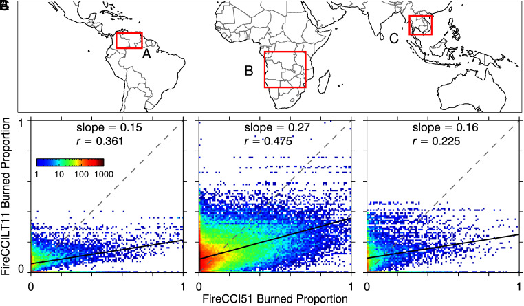
First, there is a significant lack of consistency between the FireCCILT11 0.05° product and the higher quality MODIS satellite-based FireCCI51 product used to train the statistical classifier and constrain BA proportions in the 0.05° product. The two products have major inconsistencies over regions of Africa (4) and elsewhere (Fig. 1). Overlapping these regions are extensive areas identified by ref. 1 as having some of the highest proportions of infant deaths attributable to biomass burning exposure. Pullabhotla et al. did not address the extent to which their attribution may have been influenced by FireCCILT11 BA errors.
Fig. 1.
Comparison of BA proportions defined by the FireCCILT11 0.05° product with contemporaneous 0.05° proportions derived from the independent higher quality 250-m FireCCI51 product for regions and months when burning peaked globally in February 2007 (A), August 2012 (B), and February 2007 (C). FireCCILT11 is poorly correlated (r < 0.5) and underestimates/overestimates high/low BA proportions relative to FireCCI51. The ordinary least squares regression and 1:1 reference lines are shown in solid black and dashed gray, respectively.
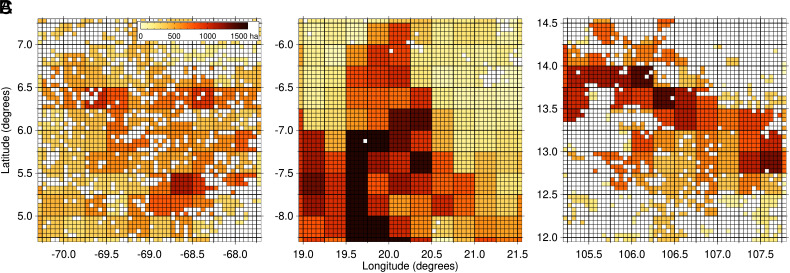
Second, the FireCCILT11 BA05 product has 0.25° blocky artifacts that make adjacent 0.05° monthly BA proportions nearly identical (Fig. 2). These artifacts likely impact Pullabhotla et al.’s analysis, given that spatial autocorrelation was a key parameter in their 0.05° BA simulation to assess measurement error impacts. The artifacts are not documented in the FireCCILT11 product user guide (6), and it is understandable that Pullabhotla et al. would not recognize this 25-fold reduced spatial resolution as an error source.
Fig. 2.
Subsets of the FireCCILT11 monthly 0.05° BA product selected from within Fig. 1 regions A, B, and C, illustrating the blocky 0.25° artifacts (0.05° pixel and 5 × 5-pixel boundaries delineated by thin and thick black lines, respectively).
Finally, we note that the FireCCILT11 validation study reported BA biases from −35 to 1125% for 2001 to 2018 (7). While the appropriateness of Pullabhotla et al. citing this study as providing “consistent and accurate estimates of BA over a long time period” is debatable, errors of this magnitude and variability reinforce the need for an explicit consideration of FireCCILT11 BA product errors in global and long-term analyses.
Acknowledgments
Author contributions
L.G. and D.P.R. analyzed data and wrote the paper.
Competing interests
The authors declare no competing interest.
Footnotes
Although PNAS asks authors to adhere to United Nations naming conventions for maps (https://www.un.org/geospatial/mapsgeo), our policy is to publish maps as provided by the authors.
References
- 1.Pullabhotla H. K., et al. , Global biomass fires and infant mortality. Proc. Natl. Acad. Sci. U.S.A. 120, e2218210120 (2023). [DOI] [PMC free article] [PubMed] [Google Scholar]
- 2.Otón G., Lizundia-Loiola J., Pettinari M. L., Chuvieco E., Development of a consistent global long-term burned area product (1982–2018) based on AVHRR-LTDR data. Int. J. Appl. Earth Obs. Geoinf. 103, 102473 (2021). [Google Scholar]
- 3.Giglio L., Roy D. P., Assessment of satellite orbit-drift artifacts in the long-term AVHRR FireCCILT11 global burned area data set. Sci. Remote Sens. 5, 100044 (2022). [Google Scholar]
- 4.Giglio L., et al. , Analysis of trends in the FireCCI global long term burned area product (1982–2018). Fire 5, 52 (2022). [Google Scholar]
- 5.Giglio L., Roy D. P., Satellite artifacts modulate FireCCILT11 global burned area. Nat. Commun., in press. [DOI] [PMC free article] [PubMed] [Google Scholar]
- 6.Otón G., “ESA climate change initiative–Fire_cci D4. 2.2 product user guide-AVHRR-long term data record (PUG-LTDR)” (Fire_cci, 2020). https://climate.esa.int/en/projects/fire/keydocuments/. Accessed 16 November 2023.
- 7.Otón G., Franquesa M., Lizundia-Loiola J., Chuvieco E., “Validation of low spatial resolution and no-dichotomy global long-term burned area product by pareto boundary” in Earth Resources and Environmental Remote Sensing/GIS Applications XII Conference (SPIE, 2021), vol. 11863, pp. 293–299. [Google Scholar]


