

Abstract
The Atacama Desert’s naturally elevated metal(loid)s pose a unique challenge for assessing the environmental impact of mining, particularly for indigenous communities residing in these areas. This study investigates how copper mining influences the dispersion of these elements in the wind‐transportable fraction (<75 μm) of surface sediments across an 80 km radius. We employed a multi‐pronged approach, utilizing spatial modeling to map element distributions, exponential decay analysis to quantify concentration decline with distance, regime shift modeling to identify dispersion pattern variations, and pollution assessment to evaluate impact. Our results reveal significant mining‐driven increases in surface concentrations of copper (Cu), molybdenum (Mo), and arsenic (As). Notably, within the first 20 km, concentrations peaked at 1,016 mg kg⁻1 for Cu, 31 mg kg⁻1 for Mo, and a remarkable 165 mg kg⁻1 for As. Cu and Mo displayed significant dispersion, extending up to 50 km from the source. However, As exhibited the most extensive reach, traveling up to 70 km downwind, highlighting the far‐reaching ecological footprint of mining operations. Mineralogical analyses corroborated these findings, identifying mining‐related minerals in surface sediments far beyond the immediate mining area. Although pollution indices based on the proposed Local Geochemical Background reveal significant contamination across the study area, establishing accurate pre‐industrial baseline values is essential for a more reliable assessment. This study challenges the concept of “natural pollution” by demonstrating that human activities exacerbate baseline metal(loid)s levels. Expanding monitoring protocols is imperative to comprehensively assess the combined effects of multiple emission sources, including mining and natural processes, in safeguarding environmental and human health for future generations.
Keywords: Atacama Desert, mining impact, soils, spatial distribution, environmental protection, indigenous communities
Key Points
Atacama mining disturbs natural metal patterns, elevating surface levels of copper, molybdenum, and arsenic
Mining dust spreads 70+ km in Atacama, posing health risks to nearby communities
The study refutes the notion that arsenic in Atacama is only due to natural processes
1. Introduction
Indigenous peoples have borne the brunt of the extractive industries’ expansion, which has been compounded by the enduring legacy of colonialism and the ongoing pursuits of state‐building and corporate‐led development (McNeish, 2022). This has occurred with scant regard for the distributive justice of the wealth generated, often leaving these communities on the margins of the economic prosperity they helped create (O’Faircheallaigh, 2013). This exploitation surpasses mere territorial infringement—it systematically violates their human rights, undermining well‐being, health, and their everyday life (Scheidel et al., 2023). The projected intensification of mineral production in forthcoming decades—predicted to occupy half of indigenous lands (Elshkaki et al., 2016; Owen et al., 2022)—signals a continuation of economic activities that deeply infringe upon their territorial rights and health sovereignty. These industries advance on the premise of dispossessing territories and resources, especially waters, historically claimed by indigenous people. Moreover, the contamination by metal(loid)s within these territories represents an insidious form of health dispossession.
Mining activities has resulted in a significant environmental impact characterized by the widespread presence of metal(loid)s in the extracting regions. This footprint poses risk to the integrity and health of the environment and nearby communities (Dai et al., 2023; Ettler et al., 2019; He et al., 2020; Tian et al., 2019). Insufficient regulation not only amplifies the risk to local populations and biodiversity, creating uncertainty about the true extent of mining impacts (Zografos & Robbins, 2020), but also contributes to perpetuates historical pollution and exacerbates environmental injustice, across various spatial scales, and particularly affecting historically marginalized populations (Rodríguez‐Labajos & Özkaynak, 2017). This silent theft manifests in the contamination of the food chain, as toxins infiltrate soil, water, and livestock, leading to the consumption of polluted food, which is detrimental to the health, cultural practices, and heritage of indigenous communities. Monitoring tends to overlook the peripheries, focusing on urban and mining hotspots, yet atmospheric contaminant transport can impose these invisible burdens on even more remote communities. This encroachment, magnified by entrenched inequalities such as limited healthcare access, perpetuates a dire legacy of environmental and human rights injustice, striking a dual assault on the core of indigenous existence and imperiling the heritage and rights of future generations. Latin America vividly exemplifies these systemic issues (Bebbington & Bury, 2013; Perreault, 2018), with the Atacama Desert serving as a clear illustration of the far‐reaching consequences for indigenous rights and environmental health due to mining practices.
Chile stands as the world’s foremost producer of copper, with its operations concentrated in the hyper‐arid expanse of the Atacama Desert (Lagos et al., 2020). The anticipated significant rise in global copper demand in the coming decades, particularly driven by the need to support the production of electric technologies for the energy transition, foresees an intensification of its environmental and social impacts (Kuipers et al., 2018). These activities have significantly impacted the delicate and valuable ecology of the desert, particularly its high Andean wetlands (R. O. Chávez et al., 2023). Moreover, they have marginalized the indigenous peoples who have long inhabited these regions (Yañez & Molina, 2008). The areas of the Atacama Desert where mining predominates have been inhabited since ancient times by indigenous communities, predominantly the Lickan Antay, Quechua, and Aymara, who traditionally engaged in agropastoral activities. These communities lay claim to a significant portion of the territory where mining activities occur. Indeed, formally organized by the state as Indigenous Development Areas (IDAs) to safeguard their rights, these territories are ostensibly recognized for protection. However, they frequently find themselves in close proximity to mining operations (Vergara et al., 2006) (Figure 1). The impacts have been significant. The literature extensively documents conflicts arising from the historical dispossession of water sources and the disruption of grazing areas due to institutional frameworks that favor mining development with very limited restrictions and private control over water resources (Babidge, 2016; Jerez et al., 2021; Molina‐Camacho, 2012; Prieto et al., 2019; Yañez & Molina, 2008). However, the literature reveals a dual gap. First, less attention has been paid to the impact of metal(loid) contamination stemming from this industry on indigenous communities. Second, the limited studies on the effects of mining on indigenous communities in northern Chile have predominantly relied on social science methodologies. While these approaches have been crucial in highlighting power asymmetries in the relation between natural resources management and Indigenous people, they have not sufficiently focused on the empirical dimension of its effects.
Figure 1.
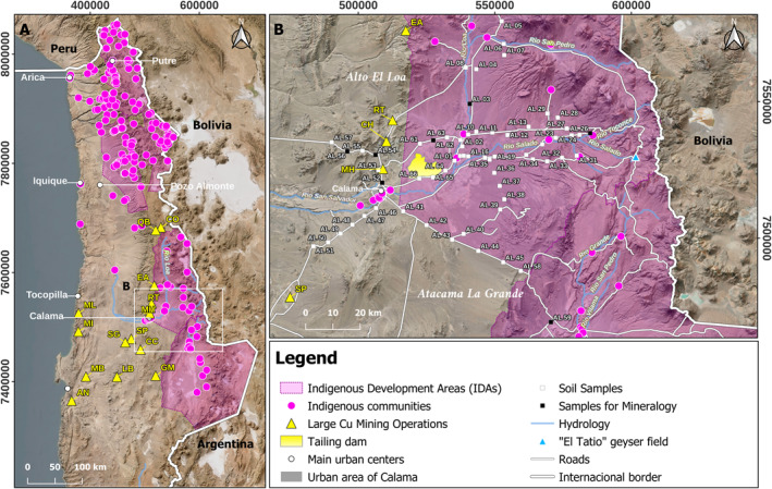
Regional and local settings. The map shows (a) the general view of northern Chile, highlighting the extensive distribution of mining sites, cities, protected indigenous areas and communities, and the location of the air quality stations of the national network. (b) Study area, including surface sediment sampling sites and potential sources of contaminants. Note that while the main mining sites are outside the protected area (IDA), the Talabre tailings impoundment is located within it. In (b), from north to south: EA = El Abra; RT = Radomiro Tomic; CH = Chuquicamata; MH = Ministro Hales; and SP = Spence. Other operations in (a), CO = Collahuasi; QB = Quebrada Blanca; ML = Mantos de la Luna; ML = Michilla; SG = Sierra Gorda; CC = Centinela; GM = Gabriela Mistral; LB = Lomas Bayas; MB = Mantos Blancos; and AN = Alto Norte.
The Chilean model of natural resource management is characterized by its neoliberal orientation, marked by limited state intervention in environmental governance (Carruthers, 2001; Tecklin et al., 2011). Within the mining sector, this approach has led to a significant safeguarding of private control over resources, particularly mining concessions and water rights. Despite CODELCO, the state‐owned copper company, being the primary producer of copper, this regulatory framework has favored a neoliberal management of the territory (Bustos‐Gallardo & Prieto, 2019). In terms of environmental policy, the framework exhibits notable restrictions, particularly concerning water and air quality. Notably, there is a significant absence of specific legislation regulating the maximum permissible concentrations of metal(loid)s in soils (Neaman et al., 2020). The country’s current environmental regulations predominantly target the reduction of emissions from short‐lived pollutants such as particulate matter (PM) and sulfur dioxide (SO2) in urban areas (Manzano et al., 2021). Despite the well‐documented adverse health effects associated with metal(loid) exposure, these pollutants have yet to be fully integrated into current and future restoration or mitigation plans.
The Atacama Desert is not only critical for understanding extractivism due to the presence of indigenous communities and fragile ecosystems, but also because of its naturally high levels of inorganic metal(loid)s (J. Tapia et al., 2018; J. S. Tapia et al., 2018), which create a complex backdrop for discerning the additional impacts of how copper mining influences their dispersion. Precisely delineating this influence has the potential to inform decision‐makers to envision tailored strategies for mitigating and remediating the environmental and health consequences from both present and future copper mining activities in the Atacama Desert. Still, several issues on the mining impact in the region have not been explored yet. Key questions about the spatial distribution and extent of metal(loid) emissions and transport, as well as their influence on existing background levels remain unanswered. To contribute to this issue, we implemented a geochemical characterization of surface sediment samples collected within an 80 km radius of the main Cu‐Mo mining operations in Chile: specifically, within the municipality of Calama (Antofagasta Region), encompassing both urban areas and the region known as Alto El Loa, which is home to both rural and urban indigenous communities (Figure 1). We tested two complementary hypotheses. First, that the mining industry today is the main driver for the surface distribution of metal(loid)s in our study area, exceeding the naturally occurring levels that are characteristic of the Atacama region. Second, that the superficial influence of the chemicals that have been released through such activities may extend over long distances due to the wind, impacting communities and ecosystems beyond current estimations.
To test our hypotheses, we analyzed the metal content of the “wind‐transportable fraction” (<75 μm, wtf) of sediment samples and used multivariate statistical analysis and spatial modeling to identify and discriminate specific metal(loid)s emission sources. Additionally, we used exponential decay analysis, regime shift modeling, and mineralogical screening to understand metal(loid) dispersion patterns, radius of influence, and infer local background levels from the results. Finally, pollution assessment models, based on the Local Geochemical Background determined in this study, were used to evaluate and quantify the environmental impact of mining activities.
In this investigation, we lay bare the intricate interplay between mining operations and their multifaceted impacts on the Atacama Desert’s ecosystem and indigenous communities. By conducting an in‐depth geochemical characterization of the area and employing advanced statistical and modeling techniques, we aim to unravel the obscured narratives of metal(loid) dispersion and its implications. Our critical analysis highlights the urgency for greater monitoring and exhaustive regulation to safeguard the health of ecosystems and communities amidst Chile’s primary economic activity. Following this introduction, the “Materials and Methods” section details our empirical approach and sampling methodology, including its limitations; “Results” presents our findings on the spatial distribution and dispersion patterns of metal(loid)s; “Discussion” interprets these results within the context of current environmental challenges; and “Conclusions” offers recommendations for future research and policy formulation.
2. Materials and Methods
2.1. Sampling Area
Our study centered on the municipality of Calama, Antofagasta Region, Chile, encompassing both urban and rural zones, with a specific focus on the Alto El Loa region (Figure 1). The area has undergone significant transformations in recent decades due to the expansion of large‐scale mining operations, which has impacted the local environment, traditional agricultural practices, rural‐urban migration, and human health (Calderón‐Seguel et al., 2021). Alto El Loa is currently the largest mining center in the country and one of the most important in Latin America. Within the area, the Chuquicamata mine has been in operation since the early 20th century, and other industrial operations, such as Radomiro Tomic (Cuadra & Rojas, 2001), El Abra (Ambrus, 1977), and Ministro Hales (Boric et al., 2009), have been active since the 1990s.
Alto El Loa is also home to the second largest Indigenous Development Area (IDA) in northern Chile. Indigenous communities in this area are exposed to emissions from various mining operations, including the largest tailing dam in the country, Talabre, which spans approximately 66 km2 (Figure 1). The Talabre tailings are particularly concerning due to their size and the high concentrations of toxic metal(loid)s. By implementing a Normalized Difference Water Index (NDWI) analysis, we previously demonstrate that their surface is predominantly dry, making it highly susceptible to dust resuspension (Zanetta‐Colombo, Scharnweber, et al., 2024; Zanetta‐Colombo et al., 2022). While dust resuspension is a common phenomenon throughout the Atacama Desert, the toxic nature of the Talabre tailings positions them as a significant stationary source of metal(loid)s dispersion in the Alto El Loa region. Furthermore, our research indicates that emission from mining operations can affect population over 50 km away due to wind action. This, in turn, demonstrates that social and environmental conflicts that arise between mining companies and indigenous communities, specifically the Lican Antay and Quechua (Yañez & Molina, 2008).
The surface material in this region primarily comprises sediments from the Calama, El Loa, and Chiu‐Chiu formations, featuring alluvial, fluvial, and eolian deposits (Blanco et al., 2003; Marinovic & Lahsen, 1984; Naranjo & Paskoff, 2010). Due to the sparse vegetation cover (Villagrán et al., 1983), these sediments have minimal organic matter content, leaving them particularly vulnerable to wind erosion and particle entrainment. This vulnerability is heightened by the region's pronounced diurnal wind patterns. During the day, prevailing winds are predominantly from the southwest, while at night, winds shift to the north and northeast. According to Muñoz et al. (2018), who utilized data from meteorological stations and tall towers, strong nocturnal down‐valley drainage flows in the high plains east of Calama are characterized by north to northeast winds until midday, transitioning to southwest winds in the afternoon. Similarly, Zanetta‐Colombo et al. (2022) illustrated through NAME dispersion model runs that daytime winds originate from the southwest and nighttime winds from the north or northeast. These patterns enhance the susceptibility of the sediments to wind erosion and particle entrainment, which significantly impacts the distribution and dispersion of metal(loid)s. For additional information on the study area’s wind patterns, please refer to Zanetta‐Colombo et al. (2022).
2.2. Sample Collection and Elemental Analyses
Sixty‐four surface sediment samples (at least 500 g for each sample at 0–10 cm depth) were collected at ∼200 m away from primary and secondary access roads in the Alto El Loa in December 2019 using a stainless steel “T” shaped auger. Sampling at this distance was chosen to minimize the potential influence of road dust and emissions on the sediment samples (Fakayode & Olu‐Owolabi, 2003; Werkenthin et al., 2014; Yan et al., 2013). Approximately 80% of the samples were collected within the Alto El Loa IDA, to the east of the potential sources of metal(loid)s (Figure 1b). Sampling along roads was necessary due to topographical constraints, which restricted our ability to access remote areas of the desert. Areas under mining companies’ concessions were inaccessible for sampling. Each representative sample is a composite formed by combining at least five subsamples collected from a 5 m2 quadrant. To prevent cross‐contamination during the sampling amongst and between sites, we used nitrile gloves, the auger was washed with demineralized water, and individual samples were stored in polypropylene bags. A portable GPS (Garmin Etrex 30 model) was used to record the geographic positions of the sampling points. The samples were transported immediately to the laboratory upon completion of the field campaign for further analysis.
Samples were processed at the Environmental Chemistry laboratory of the Pontificia Universidad Católica de Valparaiso (PUCV), Chile. The sediment samples were air‐dried and sieved (<75 μm) with a standard stainless steel mesh test sieve (ASTM E‐11/2009). Only particles <75 μm were selected for further analysis because this size range is conventionally considered as “dust,” and has been used for health risk assessment in populations exposed to potential contaminants, mainly through ingestion (Fan et al., 2022; Malakootian et al., 2021; Zhao et al., 2016). In addition, some studies indicate that this fraction may contain relatively high concentrations of metal(loid)s (Förstner & Salomons, 1980; Horowitz et al., 1990; Kolakkandi et al., 2020). This fraction will be referred to as the “wind‐transportable fraction” (wtf).
For elemental characterization, a subset (0.2 g) of the <75 μm fraction was digested in 20 mL of a multi‐acid (5 mL HNO3, 2.5 mL HCIO4, 10 mL HF, 5 mL HCl/20% HCl) and analyzed by inductively coupled plasma optical emission spectrometry (ICP‐OES, PerkinElmer Avio® 500) with spectral corrections using an ion exchange chromatography (IEC) model. Blanks and standard reference materials (OREAS 153b and OREAS 602, Melbourne, Australia) were used for quality assurance and quality control (Table S1 in Supporting Information S1). Elemental analyses were performed at the certified laboratory SGS Minerals S.A. in Santiago, Chile, with detection limits detailed in Table 1. For elements with concentrations below detection limits, missing values were estimated using half of the detection limit (Harel et al., 2014) for elements with less than 50% missing values.
Table 1.
Summary Statistics of Sediment Metal(loid) Concentrations (mg kg−1) for 64 Samples in the IDA Alto El Loa
| Element | n | dl | Mean | sd | Median | Min | Max | Range | Skew | Kurtosis | CV (%) | BVA a | UCC b |
|---|---|---|---|---|---|---|---|---|---|---|---|---|---|
| Al | 64 | 100.00 | 68,372 | 13,934 | 69,550 | 24,100 | 97,500 | 73,400 | −0.93 | 1.43 | 20.38 | 3,898.22 | 154,000 |
| Ca | 64 | 100.00 | 47,275 | 29,547 | 37,050 | 11,400 | 132,400 | 121,000 | 1.17 | 0.64 | 62.50 | – | 36,900 |
| Fe | 64 | 100.00 | 45,664 | 15,583 | 45,300 | 14,900 | 110,400 | 95,500 | 0.99 | 3.29 | 34.12 | 19,514.46 | 50,400 |
| S | 62 | 100.00 | 9,456 | 16,972 | 1,200 | 50 | 76,700 | 76,700 | 2.26 | 4.47 | 175.79 | – | 621 |
| Ti | 64 | 100.00 | 4,945 | 1,815 | 4,900 | 1,700 | 11,700 | 10,000 | 0.83 | 1.63 | 36.71 | – | 64,000 |
| Cu | 63 | 10.00 | 430.3 | 507.2 | 280.0 | 5 | 2,740 | 2,740 | 2.82 | 8.26 | 116.26 | 91.61 | 28 |
| Sr | 64 | 2.00 | 883.4 | 1,344.6 | 384.5 | 186.0 | 7,209.0 | 7,023.0 | 3.06 | 9.24 | 152.19 | – | 320.00 |
| V | 64 | 1.00 | 147.7 | 63.6 | 128.0 | 21.0 | 457.0 | 436.0 | 2.28 | 7.82 | 43.04 | 112.45 | 97.00 |
| Zn | 64 | 1.00 | 140.9 | 48.7 | 133.5 | 63.0 | 377.0 | 314.0 | 2.03 | 7.10 | 34.53 | 75.88 | 67.00 |
| As | 64 | 1.00 | 93.1 | 82.5 | 63.5 | 6.0 | 339.0 | 333.0 | 1.46 | 1.45 | 88.54 | 21.67 | 4.80 |
| Li | 64 | 1.00 | 88.9 | 44.9 | 79.0 | 23.0 | 235.0 | 212.0 | 1.19 | 1.28 | 50.44 | – | 21.00 |
| Cr | 64 | 1.00 | 37.8 | 16.7 | 34.0 | 6.0 | 97.0 | 91.0 | 1.51 | 2.83 | 44.13 | 31.84 | 92.00 |
| Pb | 64 | 1.00 | 27.8 | 8.6 | 27.0 | 11.0 | 65.0 | 54.0 | 2.07 | 6.69 | 31.01 | 12.74 | 17.00 |
| Ni | 64 | 1.00 | 19.7 | 5.4 | 20.5 | 4.0 | 33.0 | 29. | −0.28 | 1.28 | 27.14 | 41.69 | 47.00 |
| Co | 64 | 1.00 | 18.1 | 4.6 | 18.0 | 6.0 | 32.0 | 26.0 | 0.16 | 1.10 | 25.09 | 18.19 | 17.30 |
| Mo | 37 | 2.00 | 13.9 | 17.2 | 6.0 | 2.0 | 77.0 | 75.0 | 1.88 | 3.21 | 123.67 | <8.3 | 1.10 |
| Sb | 7 | 2.00 | 2.6 | 0.5 | 3.0 | 2.0 | 3.0 | 1.0 | −0.23 | −2.20 | 20.78 | – | 0.40 |
| Cd | 20 | 1.00 | 1.5 | 0.5 | 1.5 | 1.0 | 2.0 | 1.0 | 0.00 | −2.10 | 34.19 | 1.24 | 0.09 |
| Ag | 0 | 0.50 | NaN | NA | NA | Inf | ─Inf | ─Inf | NA | NA | NA | 0.98 | 0.053 |
While this approach offers valuable insights into the dispersion of metal(loid)s in the Atacama Desert, it is important to acknowledge three main limitations. First, the unconsolidated sediments sampled from the 0–10 cm surface layer, characterized by minimal organic content and limited vegetation cover (Villagrán et al., 1983), suggest a higher potential for metal(loid) mobility due to environmental factors such as wind erosion and limited water infiltration. Our decision to sample the upper 0–10 cm of the surface was intended to capture the entire surface structure, recognizing that this layer represents a dynamic interface where recent atmospheric deposition and potential re‐mobilization of older contaminants can occur. In this sense, future studies could benefit from a stratified sampling approach, which would provide more detailed insight into the vertical distribution of metal(loid)s and the specific processes influencing its mobility within these complex sedimentary environments.
Second, practical constraints impacted the sampling strategy. The suboptimal nature of the sampling, particularly in terms of quantity and distribution, presents challenges that affect the robustness of our analysis, especially concerning spatial interpolation. Restricted access to areas under mining company concession and difficulties in reaching remote locations prevented us from implementing a more systematic grid‐based sampling approach. This limitation likely introduced uncertainties into our fundings, particularly regarding the finer spatial resolution of metal(loid) dispersion.
Third, the use of hydrofluoric acid (HF) in our analysis leads to total dissolution of the mineral fraction, which may exaggerate the amount of potentially git‐assimilable contaminants. While our study focused on general contamination levels rather than specific health risk analysis, this factor should be considered in future research aimed at evaluating potential health effects to ensure accurate representation of gut‐assimilable contaminants (Castel et al., 2024; Mohanraj et al., 2024; Shentu et al., 2023).
2.3. Statistical Analysis and Models
2.3.1. Descriptive Statistics
Descriptive statistics (i.e., mean, standard deviation, skewness, kurtosis, and coefficient of variation (CV)), were used to characterize the statistical distribution of metal(loid)s within the study area. Other studies have used similar approaches in other urban settings worldwide (Fan et al., 2022; S. Hou et al., 2019). The CV was employed to describe variations in metal(loid) concentrations in surface sediments samples across our study area. This widely recognized statistical measure enable us to classify variability into four distinct levels: CV values ≤20% indicate low variability; CV values in the ranges 21%–50% and 51%–99% denote moderate and high variability, respectively. CV values >99% indicate very high variability. These classifications provide a clear framework for interpretating the consistency of metal(loid) concentration across the study area. To determine the direction and strength of the relationship between the concentration of metal(loid)s in the sediment samples, we computed Spearman correlations before verifying the non‐normal distribution of the data.
All statistical analyses were performed using the RStudio 4.2.1 statistical software (R Core Team, 2022), and all visualizations were made using ggplot2 (Wickham, 2016). Relationships between quantitative variables were evaluated using ordinary least square regression.
2.3.2. Source Apportionment
We used Principal Component Analysis (PCA) to explore potential emission sources, examining the loadings and scores to the identify factors contributing to the variability observed in the concentrations.
In the context of mapping metal(loid)s in soils and sediments, kriging is one of the most widely used geostatistical techniques for spatial modeling and prediction (e.g., Ihl et al., 2015; Tavares et al., 2008; Wang et al., 2018). In this study, the Empirical Bayesian Kriging (EBK) method was utilized to model the spatial patterns of metal(loid) concentrations. EBK offers greater flexibility compared to ordinary or simple kriging, as it can handle data sets that violate key assumptions, such as Gaussian distribution or stationarity (Gribov & Krivoruchko, 2020; Krivoruchko, 2012). Its usability in predicting metal(loid) concentration has been demonstrated in several studies (Agyeman et al., 2022; F. Li et al., 2018; Pecina et al., 2023). To account for uncertainties during semivariogram estimation, EBK employs an iterative approach by simulating multiple semivariograms and therefore allows for more robust predictions, especially in areas with sparse data. The Geostatistical Wizard in ArcGIS Pro 3.2 was utilized to perform the modeling, with a subset size of 50, 200 simulations for each metal(loid) and neighborhood type Smooth Circular with a factor of 0.5. The selection of the final semivariogram was made empirically based on cross‐validation results and the standard error map.
2.3.3. Dispersion Patterns and Radius of Influence of Metal(loid)s
We employed an exponential decay (Equation 1) approach to assess the spatial dispersion of element concentrations with respect to the distance from the identified potential emission source. The regression model took the form of:
| (1) |
where y is the concentration of metal(loid)s we are trying to predict, χ is the distance to the suspected source of metal(loid)s, and y0 denotes the concentration of metal(loid)s when χ approaches infinity. We believe this term reflects the theoretical baseline level expected in the absence of any direct effect from the suspected source (i.e., natural background level). α is the amplitude coefficient, representing the maximum potential change in metal(loid) concentration as distance increases, and β is the rate of change coefficient, which determines how quickly the metal(loid) concentration changes with increasing distance (Manzano et al., 2016; Yun et al., 2018).
Reference Geochemical Backgrounds (RGBs) such as the Upper Continental Crust (UCC) provide broad regional or global averages for natural contents of metal(loid)s, employed in studies that assess pollution levels. Kowalska et al. (2018) suggest that the Local Geochemical Background (LGB) offers a more accurate reflection of the local surface sediment geochemistry, capable of capturing local variations observed in areas with intense human activities, such as mining. Given the unique environmental conditions our study area, LGB are crucial for reliable assessment of metal(loid) dispersion and pollution levels. For northern Chile a regional background has been estimated for the Antofagasta area (Antofagasta Background Values, BVA) from soil samples at 17 “non‐contaminated” sites (CENMA, 2014), and to the best our knowledge no LGB is available for the Alto El Loa. To overcome this knowledge gap, we introduced the concept of Equilibrium Concentration (EqConc) as a proxy for LGB. It is defined as the typical element concentrations in a specific area, particularly at a distance where the concentrations can no longer be attributed to a specific source (Reimann & Garrett, 2005). The EqConc is calculated by using regimen shift analyses (Rodionov, 2015), which involve examining changes in the variance of metal(loid) concentrations at varying distances from mining sources. A stabilized decrease in the variance suggests that the composition of sediment samples have approached the EqConc, and in turn to the LGB. To validate calculated EqConc as a proxy for LGB, we compared obtained results to the BVA (Figure S1 in Supporting Information S1), but also to global Reference Geochemical Background for the Upper Continental Crust (RGB‐UCC, Rudnick & Gao, 2003).
Emission influence range (drange) were calculated using the following equation (Equation 2) (Yun et al., 2018), incorporating parameters from the exponential decay model (y0, α, β) and the EqConc as the estimated baseline level:
| (2) |
Seven samples were selected based on their individual concentration of As, Cu, and Fe, and their distance from the potential source of metal(loid)s: <20 km (n = 3), 20–40 km (n = 2), and >40 km (n = 2). Automated quantitative analysis of minerals were conducted by Scanning Electron Microscopy SEM (QEMSCAN®), which aside from the quantitative chemical characterization of materials, yields high‐resolution mineral maps and images, as well as porosity structures (Ayling et al., 2012). QEMSCAN® is a powerful technique to quantitatively estimate mineral composition, spatial distribution, and heterogeneity of specific mineral assemblages (Tuhý et al., 2020), in turn to detect and assign the origin of mining‐derived particles in sediments (Kelm et al., 2014). This is because this technique allows the analysis of thousands of particles, providing a statistically representative description of the minerals in the sample, but also allowing the identification of discrete mineral particles, their associations and the degree of liberation (Tuhý et al., 2020).
The <75 μm fraction was mixed with micronized graphite and epoxy resin (EpoFix, Struers, Copenhagen). The prepared briquettes were then polished and carbon‐coated on its surface prior to conducting the analysis. QEMSCAN® analyses were performed in a QEMSCAN® system consisting of a Quanta 250 SEM equipped with two Bruker XFlash 6130 (Silicon Drift Detector) N2‐free detectors using the PMA (Particle Mineral Analysis) mode and the CuS‐1 SIP (Specific Identification Protocol) modified for the quantification of the modal mineralogy of the samples, and a point spacing of 5 μm. The Idiscover‐Imeasure 5.3 platform was used for data analysis.
2.3.4. Pollution Assessment
The Enrichment Factor (EF) (Equation 3) and Geoaccumulation Index (Igeo) (Equation 4) were used for pollution assessment. Both are typically used to characterized pollution degrees in environmental matrixes (Barbieri, 2016), and together allow us to evaluate anthropogenic enrichment of the wtf across the local surface:
| (3) |
| (4) |
where in Equation 2, M is the concentration of the element being analyzed and X is the concentration of the reference element; and in Equation 3, C n is the measured concentration of element, B n is the geochemical background, and 1.5 is a factor used to include the possible variation of background values due to lithogenic effects (Müller, 1979). To calculate the EF, we used Al as the reference lithogenic element (CV: 20%) as it represents one of the most abundant elements in surface sediments (Lindsay, 1979). If the EF ranges from 0.5 to 1.5, natural weathering processes or crustal material might be influencing the found concentration. When EF > 1.5, anthropogenic activities might be influencing it. According to EF, the following classes were defined: deficiency to minimal enrichment (EF < 2), moderate enrichment (2 < EF < 5), significant enrichment (5 < EF < 20), very high enrichment (20 < EF < 40), and extremely high enrichment (EF > 40) (Barbieri, 2016).
The Igeo was evaluated following the classification proposed by Müller (1981): uncontaminated (Igeo ≤ 0), uncontaminated to moderately contaminated (0 < Igeo < 1), moderately contaminated (1 < Igeo < 2), moderately to heavily contaminated (2 < Igeo < 3), heavily contaminated (3 < Igeo < 4), heavily to extremely contaminated (4 < Igeo < 5), and extremely contaminated (Igeo ≥ 5).
3. Results
3.1. Concentration of Metal(loid)s Across the Local Surface
Our analysis of the wtf of 64 sediment samples across the Alto El Loa surface revealed distinct patterns in element concentration and variability (Table 1). In descending order of mean concentration, the dominant elements within the major element category were Al, Ca, Fe, S, Ti, and Sr. Cu, V, Zn, As, Li, Cr, Pb, Ni, Co, Mo, Sb, and Cd comprised the trace elements listed in order of decreasing mean concentration. It is important to note that Cr and As concentrations are reported as total values, not species‐specific. This means that Cr values include both Cr(III) and Cr(VI) forms, with Cr(VI) being more hazardous (Wise et al., 2022), and As values encompassing all species without differentiation, with inorganic forms being more toxic (Tchounwou et al., 2019).
All samples contained Ag concentrations below detectable limits, as well as some samples for Sb (57 samples), Cd (44 samples), Mo (27 samples), S (2 samples), and Cu (1 samples).
The analysis revealed that S, Sr, Mo, Cu, and As exhibited highest CV, with values 176%, 152%, 124%, 116%, and 89%, respectively. Such observed variability suggests the impact of multiple potential sources for these elements within the study area. When compared to BVA and the RGB‐UCC, we found that As, Mo, and Cu concentration in the surface sediments within our study area are exceptionally high. Specifically, these elements exhibit maximum concentration approximately 16, 9, and 27 times higher than BVA, respectively. While the maximum S content was approximately 124 times higher than the UCC level. These findings highlight a significant increase in element concentrations relative to both regional and global reference backgrounds.
Correlation analyses indicate a potential common source for S, Sr, Mo, Cu, and As across the Alto El Loa (Table S2 in Supporting Information S1). Actually, we verified positive, strong and statistically significant correlations (p ≤ 0.001) between S and Sr (ρ = 0.787), Cu and Mo (ρ = 0.784), As and Mo (ρ = 0.726). While As and Cu (ρ = 0.604), As and Ca (ρ = 0.660), and As and S (ρ = 0.577) are moderately and positively correlated. Crustal elements (i.e., Al, Ti, Fe, Ni, Cr, and Co) show weak correlations with metal(loid)s associated with mining activities (Table S2 in Supporting Information S1). However, all of these geogenic elements are positively and statically significant correlated with each other (Table S2 in Supporting Information S1), exhibiting moderate variability, with CV values ranging from 20.3% to 44.1% (Table 1).
3.2. Source Estimations
3.2.1. Principal Component Analysis (PCA)
To delve deeper into the relationships between elements and explore their potential sources, we employed principal component analysis (PCA). Notably, Ag, Sb, and Cd were excluded due to their frequent presence of concentrations below detectable limits in 100%, 89%, and 69% of the samples, respectively. Missing values for Mo (n = 27) were addressed by substituting them with half of the instrumental detection level (refer to Table 1 for details). The component matrix after rotation is presented in Table 2. The results revealed that the first three principal components (PCs) captured over 80% of the total variance observed in the elemental composition of the wtf across the Alto El Loa surface. PC1 (35.5% of the total variance) is dominated by geogenic elements such as V, Cr, Ti, Fe, Co, and Ni. PC2 (19.0% of the total variance) incorporated Cu, Pb, Mo, Zn, and As. PC3 (27.7% of the total variance) encompasses elements such S, Ca, Sr, As, and Li.
Table 2.
Matrix for Loads With Three Principal Components (PC1, PC2, PC3) Obtained in the Principal Component Analysis (PCA)
| Variable | PC1 | PC2 | PC3 |
|---|---|---|---|
| Al | 0.22 | 0.12 | −0.89 |
| Ca | −0.34 | 0.12 | 0.85** |
| Fe | 0.91** | −0.36 | |
| S | −0.25 | 0.86** | |
| Ti | 0.92** | −0.35 | |
| Sr | −0.15 | 0.79** | |
| Cu | −0.12 | 0.91** | 0.19 |
| V | 0.97** | ||
| Zn | 0.37 | 0.76** | −0.20 |
| As | −0.30 | 0.57* | 0.58* |
| Li | −0.41 | 0.53* | |
| Cr | 0.95** | −0.17 | |
| Pb | 0.14 | 0.82** | −0.28 |
| Ni | 0.82** | −0.43 | |
| Co | 0.88** | 0.11 | −0.37 |
| Mo | −0.19 | 0.76** | 0.44 |
| SS loadings | 5.687 | 3.035 | 4.433 |
| Variance % | 0.355 | 0.190 | 0.277 |
| Cumulative Variance % | 0.355 | 0.545 | 0.822 |
Note. (**) indicate strong positive loadings (loadings >0.75), while (*) indicate moderate positive loadings (loadings between 0.50 and 0.75).
3.2.2. Spatial Modeling
The spatial interpolation of metal(loid) concentrations reveals their intricate distribution across the study area.
Analyzing elements grouped in PC2 (Figure 2) unveils a striking relationship with the Cu‐Mo mining site. Cu, Mo, and As concentrations exhibit a pronounced decline as the distance from the mining operations increases, highlighting their direct relation with the Cu‐Mo extraction sites (open pits). This trend is particularly evident for these elements, as no other significant emission sources are readily apparent. In contrast, Pb and Zn exhibit a primary hotspot near the open pits, hinting at additional emission sources beyond the mines.
Figure 2.
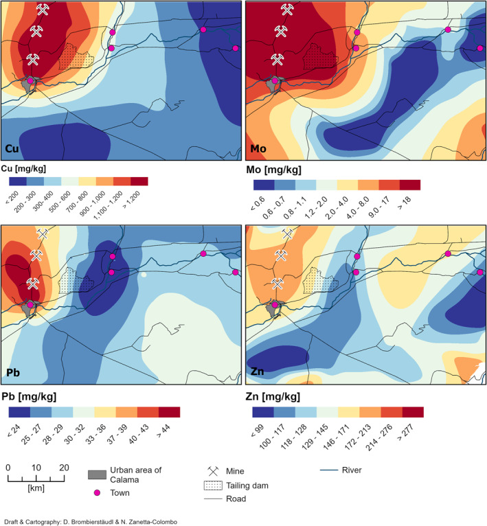
Spatial Distribution of copper (Cu), molybdenum (Mo), lead (Pb), and zinc (Zn) concentrations (PC2) in the wind transportable fraction (wtf) extracted from sediments in Alto El Loa, relative to potential emission sources.
Shifting focus to elements associated with PC3 (Figure 3), we observe a stronger association with potential dust resuspension from the Talabre tailings dam. This spatial pattern, characterized by lower concentrations further away from the dam, suggests a spatial influence. The discernible distribution of these elements further reinforces this link.
Figure 3.
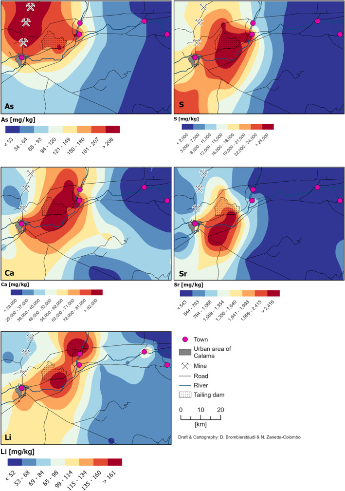
Spatial Distribution of arsenic (As), sulfur (S), calcium (Ca), strontium (Sr), and Lithium (Li) concentrations (PC3) in the wind transportable fraction (wtf) extracted from sediments in Alto El Loa, relative to potential emission sources.
Detailed visuals and statistical analyses supporting these observations (including Root‐Mean‐Square Standardized (RMSS), mean standardized error, and standard errors maps) are provided in Supporting Information S1 (Table S3, Figures S2, and S3).
3.3. Spatial Extent of Impact
3.3.1. Relationship Between Concentration and Distance From the Sources
To assess how mining activities affect metal(loid) dispersion in Alto El Loa, we analyzed their concentrations in the wind‐transportable fraction (wtf) relative to their proximity to emission sources. We focused on the two potential sources identified earlier: Cu‐Mo ore extraction (PC2) for Cu, Mo, As, Pb, and Zn, and dust resuspension from Talabre tailings (PC3) for S, As, Ca, and Sr. Figures 4 and 5 show how metal(loid) concentrations in the wtf decrease with increasing distance from the sources, based on an exponential decay model.
Figure 4.

Scatter plots of metal concentrations in the wind‐transportable fraction (wtf) in sediments of the Alto El Loa IDA (n = 64) corresponding to an increasing distance from the mine tailing dam for Cu, Mo, As, Pb, and Zn (PC2). Red trend lines depict exponential decay models. The horizontal dashed red line represents the plateau (y0) obtained from the model, while the dashed blue line indicates the Equilibrium Concentration (EqConc) post‐regimen shift analysis. Samples highlighted in orange were used for detailed mineralogical analyses (see Section 3.3.2).
Figure 5.
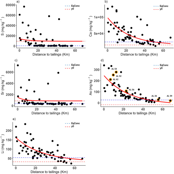
Scatter plots of metal concentrations in the wind‐transportable fraction (wtf) in sediments of the Alto El Loa IDA (n = 64) corresponding to an increasing distance from the mine tailing dam for S, Ca, Sr, As, and Li (PC3). Red trend lines depict exponential decay models. The horizontal dashed red line represents the plateau (y0) obtained from the model, while the dashed blue line indicates the Equilibrium Concentration (EqConc) post‐regimen shift analysis. Samples highlighted in orange were used for detailed mineralogical analyses (see Section 3.3.2).
Metal(loid) concentrations generally declined with distance from both the mine and tailings (Table 3, Figures 4 and 5). Decay rates (β) varied between 0.04 and 0.15, with Sr exhibiting the fastest decline and Ca the slowest. The coefficient of determination (R‐squared) indicated a good fit for most elements (R‐squared > 0.4), except Zn (PC2), S, and Sr (PC3).
Table 3.
Coefficients of the Exponential Decay Equations, Regime Shift Analysis and Influence Ranges From Mines and Tailings
| Element | Exponential decay model | Regime shift analysis | Range of influence (km) | |||||
|---|---|---|---|---|---|---|---|---|
| Distance | y0 | α | β | r2 | RS (km) | EqConc | ||
| Cu | ∼Mines | 178.47 | 1,824.03 | 0.07 | 0.4035 | (1) 16.71; (2) 35.92 | 240 | 48.41 |
| Mo | ∼Mines | −0.2 | 55.62 | 0.07 | 0.4863 | (1) 19.92; (2) 35.92 | 1.67 | 48.47 |
| As | ∼Mines | −45.07 | 311.61 | 0.02 | 0.5298 | (1) 29.58; (2) 45.77 | 28.3 | 72.31 |
| Pb | ∼Mines | 25.58 | 39 | 0.14 | 0.3706 | NA | 27.75* | 20.63 |
| Zn | ∼Mines | 171.7 | −19.63 | −0.01 | 0.0154 | NA | 140.93* | 44.94 |
| S | ∼Tailings | 9,340.46 | 4,758.49 | 0.09 | 0.0621 | (1) 10.27; (2) 31.94; (3) 42.84 | 564 | NULL |
| Ca | ∼Tailings | 14,510.68 | 84,183.75 | 0.04 | 0.4392 | (1) 17.52; (2) 42.84 | 23,986 | 54.60 |
| As | ∼Tailings | −16.86 | 265.27 | 0.04 | 0.5883 | (1) 17.87; (2) 37.54 | 26.3 | 45.4 |
| Sr | ∼Tailings | 877.23 | 647.16 | 0.15 | 0.0796 | (1) 12.60; (2) 31.94; (3) 42.84 | 374 | NULL |
| Li | ∼Tailings | 32.31 | 129.62 | 0.04 | 0.4672 | (1) 19.15; (2) 43.23 | 58.8 | 43.78 |
Note. (*) indicates the average concentrations in Alto El Loa. In the Regime Shift Analysis (RS (Km)), bold distances indicate the final breakpoint before variance stabilization. After this breakpoint, the average concentration is referred to as EqConc.
Further analysis identified breakpoints in the spatial variability of metals(loids) concentrations, with the final breakpoint indicating a stabilization in variance. This stabilization suggest equilibrium in dispersion patterns, which we use to calculate average concentrations beyond this point, representing LGB (or EqConc in this study). This resulted in EqConc values ranging from 26.30 mg/kg (As) to 23,986 mg/kg (Ca).
Combining the results of the exponential decay model and regime shift analysis, we calculated the range of influence (Drange) for each element, ranging from 20.63 km (Pb) to 72.31 km (As) (Table 3).
3.3.2. Mineralogy Analyses
The mineralogical composition of analyzed sediment samples is shown in Table S4 of the Supporting Information S1. QEMSCAN® analyses revealed diverse sediment mineralogy, with variations in composition and mineral associations across different distances from emission sources. Overall, a decrease in Cu‐sulfide and As mineral concentrations was observed with increasing distance from the mines and tailings.
Samples within 20 km of the emission sources showed the highest Cu sulfide content, dominated by chalcocite/digenite/covellite over oxidized Cu minerals, suggesting primary and secondary sulfide oxidation and potential As co‐occurrence. Notably, the identified Cu‐As sulfide levels (up to 0.03%) matched the As concentrations. Two samples contained low‐concentration (0.01%) molybdenite, significant due to its non‐natural origin and association with chalcopyrite and bornite, minerals typically found only in deeper zones of Cu‐Mo deposits (W. X. Chávez, 2000). This suggests the transport and deposition of mining/tailings processing particles on the region.
Samples between 20 and 40 km away from the emission sources showed consistently lower total Cu, Cu‐sulfides (∼10 times lower), and pyrite concentrations than the <20 km range (Figure 6). Sample AL3, closer to the Talabre tailings impoundment, exhibited higher Cu‐sulfides and oxidized Cu minerals than AL56 near the Cu‐mining operations. This shared mineralogy, particularly the presence of chalcopyrite and molybdenite, points to anthropogenic particles even at this distance (Figure S4 in Supporting Information S1).
Figure 6.
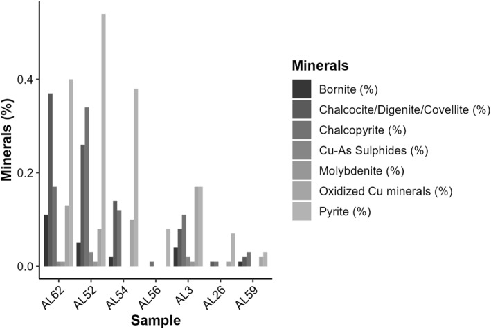
Mineralogy (sulfide phases) of the <75 μm fraction (wtf) of selected surface sediment samples as a function of the distance from the possible pollution sources (Distance < 20 km: Samples Al62, AL52, and AL54; Distance 20–40 km: Samples Al56 and AL3; Distance >40 km: Samples Al26 and AL59). See Figure 1 for the location of the samples used for this analysis.
Samples farthest from the emission sources, at distances greater than 40 km, presented negligible sulfide content (≤0.11%). Interestingly, sample AL26 exhibited a shift in mineral composition, with higher concentrations of alteration minerals and carbonates compared to Fe oxides‐hydroxides (Figure S4 in Supporting Information S1). However, QEMSCAN® analysis proved ineffective in elucidating the specific minerals present or their origin within this furthest distance range.
3.4. Pollution Assessment
The Enrichment Factor (EF) and Geoaccumulation Index (Igeo) for Alto El Loa are detailed in Table S5 and Figure S5 of the Supporting Information S1. EF and Igeo were computed using average background values for the BVA (CENMA, 2014) and estimated values RGB‐UCC (Rudnick & Gao, 2003). Additionally, the EqConc, determined in the preceding section through dispersion and regime shifts analysis, was employed as a local alternative for these assessments (Figures 4 and 5, and Table 3). S and Sr were excluded from the pollution assessment due to the absence of BVA, making them unsuitable for comparison purposes (CENMA, 2014).
The EF of As, Cu, and Mo exhibits a decreasing pattern with distance from the source, regardless of the geochemical background used (Figure 7 and Figure S5 in Supporting Information S1). While using BVA indicates a deficiency to minimal enrichment for As, Cu, and Mo across the entire Alto El Loa region, using global RGB‐UCC values presents a significantly different scenario. The EF for As within the initial 20 km were approximately 170 times higher when employing UCC (EF = 111.0) compared to BVA (EF = 0.625), indicating extremely high enrichment, even 20–40 km from the sources (EF = 65.4). Similar differences can be found for Cu and Mo when comparing both reference values (Figure S4, Table S6 in Supporting Information S1). Using EqConc at the local scale reveals more conservative results. However, significant enrichment is indicated for As (EF = 8.39) and Cu (EF = 5), along with very high enrichment for Mo (EF = 23.5) within the initial 20 km. These enrichments surpass the results obtained using regional values (BVA) by 13, 7, and 18 times, respectively.
Figure 7.
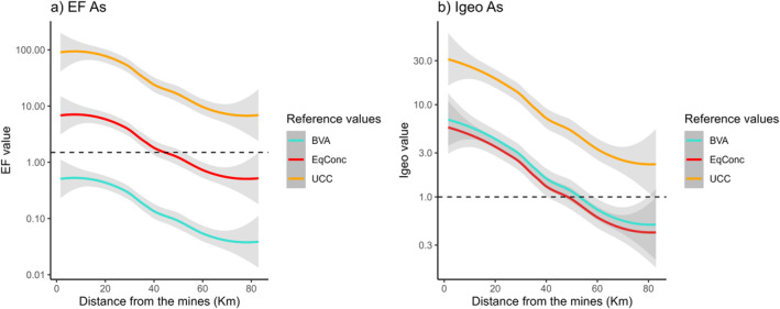
Comparison of contamination index results for arsenic using different reference levels. (a) Enrichment Factor (EF) and (b) Geoaccumulation Index (Igeo). In the legend, BVA corresponds to the geochemical background values of the Antofagasta region and UCC to those of the Upper Continental Crust. The values proposed as Equilibrium Concentration, EqConc are presented with the red curve.
The Igeo results also depend on the reference value used. For example, like EF, the Igeo for As using UCC were 4.5 times higher than when using BVA and 5.9 times higher than when using EqConc as the background value within the first 20 km from the sources. A similar difference was observed in the range 20–40 km. While using UCC beyond 40 km, the resulting levels indicated extremely contaminated conditions for As. In contrast, using regional (BVA) and local (EqConc) values, the levels were categorized as moderately contaminated and uncontaminated to moderately contaminated, respectively.
4. Discussion
4.1. Copper Mining and Pollutant Distribution in the Atacama
Despite the robust body of research highlighting the natural geochemical processes in the Atacama Desert (J. Tapia et al., 2018; J. S. Tapia et al., 2018; J. Tapia et al., 2021), there remains a notable gap in comprehensively addressing the effect of mining on metal(loid) dispersion in the area.
While some studies have highlighted mining‐related pollution (e.g., Aránguiz‐Acuña et al., 2020; Moya et al., 2019; Pérez‐Portilla et al., 2024; J. Tapia et al., 2018; J. S. Tapia et al., 2018; Valdés, 2012; Valdés et al., 2011; Zanetta‐Colombo, Scharnweber, et al., 2024; Zanetta‐Colombo et al., 2022), the prevailing narrative often downplays the impact of mining as a significant source of contamination. This is not so much due to a lack of awareness, but rather the absence of robust quantitative data, which makes it challenging to assess the problem accurately. Consequently, within the academic field of Earth Sciences, as well as among private and state actors, the issue tends to be ignored or underestimated. As a result, research has predominantly focused on the natural process that releases toxic metal(loid)s, particularly arsenic (As), into the surface of the Atacama Desert. These studies have examined surface geochemistry, linking it with rock composition (cobalt (Co), chromium (Cr), iron (Fe), manganese (Mn), vanadium (V), zinc (Zn)) and the chemistry of salt flats and evaporites (As, boron (B), lithium (Li)). Additionally, there has been considerable investigation into the natural presence of As in water sources and its impact on human health. Arriaza (2005) and Byrne et al. (2010) provide evidence that the inhabitants of the Atacama Desert, over 7,000 years ago, were exposed to high concentrations of As (exceeding 10 μg/g). This long‐term exposure suggests that these early populations may have developed a metabolic adaptation to naturally arsenic‐contaminated environments (Apata et al., 2017).
This tendency to downplay mining’s role (Romero et al., 2003) leads to the naturalization of pollution and inadvertently reproduces false notions about the Atacama Desert as a place where presence and dispersion are solely at the whim of nature, underestimating the true ecological consequences of mining activities (Alam et al., 2023). This is particularly relevant in a country in which economic development often takes precedence over the environmental repercussions of mining (Lagos & Blanco, 2010), especially in territories ancestrally inhabited by indigenous communities that claim them and are disproportionately affected by this industry. In this sense, this work reveals the complex interplay between scientific understanding, public perception, policy decisions, and environmental and social justice (Ibarra et al., 2018). In this context, our study adds valuable insights by elucidating shifts in metal(loid) dispersion associated with mining activities, thereby contributing to visualize the effects of mining as a responsible actor in the production of a desert with metal(loid)s, allowing for a comprehensive understanding of the environmental landscape in the Atacama Desert beyond a territory “contaminated by nature.”
Previous studies have explored the impact of human activities, particularly in relation to elements like copper (Cu), molybdenum (Mo), and lead (Pb) (J. Tapia et al., 2018; J. S. Tapia et al., 2018). While our findings are consistent with this connection, we provide a unique perspective on As distribution across the Atacama Desert. Our research suggests that mining plays a dominant role in shaping the spatial distribution of arsenic (Figures 3, 4, 5). This is supported by strong positive correlations between As and elements like Cu (r = 0.604, p < 0.001) and Mo (r = 0.726, p < 0.001), which also share positive loadings in the same principal components (PC2, Table 3), highlighting their common sources. This challenges the prevailing narrative that often attributes the presence of As solely to natural geochemical processes in the region.
The distribution of Pb across the Alto El Loa region indicates the influence of multiple sources, both historical and contemporary. A potential source is the use of diesel engines in indigenous communities, particularly for transportation and power generation. During our field visits, we observed the reliance on diesel generators in areas with intermittent energy supply, such as the Caspana school. This suggests that the use of diesel fuel may have contributed to localized Pb contamination. Our previous findings, including dust sample analyses from these communities, also point to diesel engines as a possible source of Pb (Zanetta‐Colombo et al., 2022). In addition, Calama, the largest urban center in the area, hosts the only lead‐acid battery recycling plant in Chile. This facility represents a significant point source of Pb emissions in the area. Other industrial operations, including the “Puerto Seco” (or “dry port” in English) and various logistics activities associated with mining, could also contribute to the Pb load in the atmosphere, particularly through the movement of heavy trucks and machinery. While leaded gasoline was phased out in Chile during the 1990s (and banned from 2003), residual Pb from past emissions could still be present in surface sediments, particularly in urban areas like Calama (Eichler et al., 2015; Gayo et al., 2022). This legacy pollution, combined with current emissions, underscores the complex nature of Pb distribution in the region.
The urban scale, exemplified by the city of Calama, is a critical area for understanding the cumulative impact of multiple Pb sources. Therefore, future studies should focus on more localized urban investigations to achieve a higher spatial resolution and better identify specific sources of Pb contamination. This approach will be essential for developing targeted mitigation strategies and protecting public health in affected communities.
Agricultural practices in the Alto El Loa region appear to have a minimal impact on the distribution of metal(loid)s. Farming in the Atacama villages is primarily subsistence‐based (Calderón et al., 2016), with limited use of herbicides and pH‐stabilizing agents. For example, a local farmer mentioned using 2,4‐D (2,4‐Dichlorophenoxyacetic acid), a herbicide known as “Mata Maleza,” which typically does not contain significant metal(loid) levels. In contrast, mining activities have a more substantial impact on local agriculture, increasing concentrations of metal(loid)s like Cu and antimony (Sb) in crops near mining operations (Gregori et al., 2003). Consequently, the influence of agriculture on metal(loid) distribution is likely negligible. Our sampling strategy intentionally avoided indigenous villages to minimize the influence of local emissions and ensure that the observed element distribution reflects broader regional contamination patterns.
While our study focuses on local contamination sources in Alto El Loa, itis important to acknowledge potential external influences. The Antofagasta region’s extensive mining activities (Figure 1a) could affect metal(loid) distributions. For example, major mines like Quebrada Blanca (QB) and Collahuasi (CO) to the north, and Gabriela Mistral (GM) to the south, might contribute to regional contamination. Additionally, our sulfur (S) distribution analysis (Figure 3) suggests possible impacts from sources such as Sierra Gorda (SG) and Spence (SP) to the southwest. Emissions from the port of Antofagasta (∼230 km away), which has been a copper concentrate stockpile since 2014, and from coal‐fired plants in Tocopilla (∼160 km) and Mejillones (∼200 km) (García et al., 2024; J. Tapia et al., 2018; J. S. Tapia et al., 2018; Valdés, 2012) could also reach the study area. However, our analysis does not show evidence of their impact. To better understand the potential effects of these distant sources, more detailed analyses, such as isotopic testing, are needed. Despite this, our findings indicate that local mining activities are the primary sources of contamination in Alto El Loa.
4.2. On the Far‐Reaching Geochemical Footprint of Mining
Another crucial aspect of our results revolves around the far‐reaching impacts of mining emissions. Many studies have been recently carried out on the impact of mining activities globally, they often focus on the surroundings of mining sites and urban areas (Childebayeva et al., 2021; Gayo et al., 2022; Gillings et al., 2022; Ke et al., 2022; W. Li et al., 2022; Liu et al., 2022; Ma et al., 2022; J. S. Tapia et al., 2018; Tian et al., 2019). It must be recognized that the impact of mining is more critical in areas close to operations (Figures 2 and 3), but the lack of monitoring and focus on urban areas means that many vulnerable territories –i.e., rural areas– may be experiencing uncertainty about the level of pollutants in their environments and their effects on health (Gani et al., 2022). This is particularly true in the context of indigenous and peasant lands, where around half of all mining projects are situated (Owen et al., 2022).
Indeed, our results suggests that emissions from mining activities travel farther than expected. These emissions significantly affect the concentration of metal(loid)s in the surrounding environment. As exhibits the greatest reach, extending approximately 70 km from the source. Both Cu and Mo show significant dispersion, impacting areas up to 50 km away. Pb, however, has a more localized impact, with elevated levels primarily observed within 20 km of the emission source. This agrees with the findings of previous studies in the area (Zanetta‐Colombo, Scharnweber, et al., 2024; Zanetta‐Colombo et al., 2022) and other areas heavily burdened by mining activity in South America (Dame et al., 2023; Gayo et al., 2022; Molloy et al., 2020).
Our mineralogical analysis revealed a clear pattern: Cu‐sulfide phases in sediments within the 20 km buffer zone consistently increased compared to those farther away (20–40 km). This aligns perfectly with our findings on metal(loid) dispersion, where significant mining influence extended up to 40 km. Notably, the mineral association of molybdenite‐chalcopyrite‐bornite, typically found deep within the area’s porphyry Cu‐Mo deposits (W. X. Chávez, 2000), was prevalent in these surface sediments. This suggests a strong connection between their presence and the transport and deposition of particles originating from Cu‐Mo mining activities, spanning up to 40 km. Additionally, this association could be linked to the transport of non‐recovered minerals from the nearby Talabre tailings facility.
4.3. Relevance of Local Geochemical Background Values in Pollution Assessment
Pollution indexes, such as the one employed in this study, are widely acknowledged as valuable tools for assessing the contamination levels and evaluating sediment and soil quality and ecosystem sustainability (Kowalska et al., 2018). However, the reference values used are crucial in determining the success of the tools. The utilization of representative background values at varying spatial scales (global, regional, and local) significantly influences the results, potentially resulting in either overestimation or underestimation of the enrichment (Figure 7 and Figure S5 in Supporting Information S1). Some studies utilize a range of background values for assessment, which enhances the interpretative depth (J. Tapia et al., 2018; J. S. Tapia et al., 2018; Valdés, Marambio‐Alfaro, et al., 2023; Valdés, Ortlieb, et al., 2023). Establishing accurate baseline contaminant levels in Chile poses challenges due to the scarcity of background or pre‐industrial values. While some studies have attempted to determine contaminant concentrations prior to anthropogenic influences (Gayo et al., 2022; Valdés, Ortlieb, et al., 2023), it is noteworthy that paleoenvironmental research in the Atacama (Gayo et al., 2019) suggests that pristine conditions may not have existed for at least 1,500 years due to pre‐Hispanic metallurgy emitting significant pollutants. This highlights the contextual nature of pre‐industrial background values and underscores the importance of establishing such values in locations distant from mining centers, which have been occupied since pre‐Hispanic times.
This study compared results obtained using the Upper Continental Crust (UCC), a widely employed global standard, with regionally estimated background levels (BVA). However, these BVA values were derived from soil samples collected in ostensibly “uncontaminated” areas, a notion open to debate. Antofagasta has been a pivotal region in the mining industry since the early 20th century, witnessing extensive mining activity sprawling across the territory (Figure 1). Given the significant radius of dust emissions’ influence from mining operations, as observed in this study (50–70 km) (Figures 2, 3, 4, 5), the notion of “uncontaminated” zones demands careful examination. Additionally, regional concentration averages, as utilized in BVA, may underestimate or overestimate contamination levels at the local scale.
In the absence of pre‐industrial values, this study proposes using concentrations that appear unaffected by mining activity, determined by their distance from identified emission sources and variance stability (i.e., EqConc.). The results presented here potentially yield more accurate assessments than those derived from global (UCC) and regional (BVA) geochemical backgrounds (Figure 7). While we acknowledge that EqConc cannot strictly be considered a true geochemical background, it represents concentrations likely to be less influenced by ongoing industrial activities. Despite the inherent uncertainty associated with these concentrations, their use in calculating contamination and enrichment indices offers a more coherent and relevant approach. This approach reduces the risk of over‐ or underestimating contamination levels compared to relying solely on regional or global geochemical backgrounds.
5. Conclusions
Our study yields crucial insights into the distribution of metals and metalloids (metal(loid)s) in the Atacama mining hotspot, offering significant implications for advancing monitoring protocols and environmental regulations. We identified three distinct metal(loid) sources: mining operations (copper [Cu], molybdenum [Mo], arsenic [As]), tailings dust resuspension (As, sulfur [S], calcium [Ca], strontium [Sr]), and natural background (iron [Fe], titanium [Ti], vanadium [V], chromium [Cr], nickel [Ni], cobalt [Co]). Notably, concentrations displayed characteristic shifts with distance. Exponential decay analysis and regime shift detection revealed that Cu and Mo impacts extend approximately 50 km from the open pits. Meanwhile, arsenic—originating from both mining operations and natural sources—can spread up to 70 km.
While existing research has recontextualized the Atacama as more than a hyper‐arid territory by emphasizing the extractive industries’ influence on water management (Prieto et al., 2019), the analysis we present here urges a critical examination of the normalization of pollution in the Atacama Desert. Despite the undeniable presence of metal(loid)s from natural sources, this work clearly delineates the significant role of mining in their dispersion. The distribution of these metal(loid)s is shown to be non‐arbitrary, with marked effects on indigenous communities who face not only territorial dispossession but also disproportionate exposure to mining‐related metal(loid)s.
This study calls for a thorough reassessment of how mining influence areas and so‐called “sacrifice zones”—regions historically designated as areas disproportionately burdened by environmental degradation and health risks—are defined (Gayo et al., 2022). Often, these zones are represented merely as discrete Euclidean polygons, which fail to reflect the true extent of environmental and human impacts (Prieto & Zanetta‐Colombo, 2024).
The metaphor of metal(loid)s “blowing in the wind” conveys the extensive reach of contamination, challenging traditional delineations of impact zones and demanding a reevaluation of how we monitor and manage mining’s influence. The oversimplification of metal(loid) dispersion contributes to political inaccuracies and, consequently, environmental injustice, perpetuating the dispossession that indigenous peoples have historically endured.
To address these challenges, our research emphasizes the need for several critical actions: (a) establishing accurate pre‐industrial baseline values for reliable pollution assessments, (b) expanding monitoring protocols to comprehensively understand the combined effects of multiple emission sources, (c) implementing regulations to set acceptable concentrations in soil, surface sediments, settled dust (indoor/outdoor) and other matrices, alongside protective environmental standards, and (d) minimizing exposure risks associated with metal(loid)s in regions with a history of mining activity.
Furthermore, a supplementary point relates to the necessity of lifting barriers that the mining sector imposes on science. The limitations on accessing sites controlled by mining underscore the need to open these areas to scientific research to ensure comprehensive evaluations. These restrictions call for greater transparency within the mining sector. Ensuring free access for scientific inquiry is a fundamental condition to facilitate an informed dialog on sustainable practices, crucial for the development of policies that accurately reflect the ecological impacts of mining activities. Finally, recognizing that the dispersion and levels of metal(loid) contamination are the result of an interplay between natural conditions and the mining industry, it is imperative to strengthen a research agenda that seriously considers this nexus and integrates both natural and social sciences (Lave et al., 2014).
Additionally, it is important to consider transboundary contamination problems for further study (Eichler et al., 2017). The study area is very close to the border with Bolivia and Argentina. Political boundaries present another obstacle to scientific research, and indigenous communities across the borders may also be affected by these issues. Addressing these challenges requires coordinated international efforts and policies to ensure environmental justice across borders (L. Hou et al., 2021).
By diligently implementing these recommendations, we can foster robust scientific agenda alongside environmental protection and safeguard public health in areas impacted by mining activities. This proactive approach transcends the Atacama Desert, extending to similar afflicted regions globally. By prioritizing responsible practices and sound regulations, we can prevent the fate of detrimental emissions from becoming another element “blowin” in the wind.
Conflict of Interest
The authors declare no conflicts of interest relevant to this study.
Supporting information
Supporting Information S1
Acknowledgments
The authors thank the indigenous communities of Alto El Loa who made this work possible. Nicolás Zanetta‐Colombo thanks Lourdes Flavià Forcada and José Castaño Ruiz (Murtra Santa María del Silencio—https://murtra.org/) for their support in the lodging during the sampling campaign; Rodrigo Veto and Nicolás Zúñiga (https://www.veto.cl/) for the donation of the soil sampling auger; and Waldo Quiroz (Pontificia Universidad Católica de Valparaiso) who supported the pre‐treatment of the samples. Nicolás Zanetta‐Colombo is especially grateful to the Deutschen Akademischen Austauschdienstes (DAAD) for providing funding for the development of his doctoral thesis (funding program “Research Grants—PhD Programs in Germany, 2020‐21”). We thank the Centro de Investigación en Tecnologías para la Sociedad C+, Facultad de Ingeniería, UDD, and the Agencia Nacional de Investigación y Desarrollo de Chile (ANID) through FONDEQUIP Mayor Grant EQY200021 and FONDECYT Grant 1221951 for supporting the commercial laboratory analysis. We would also like to thank the ongoing support by the Center for Climate and Resilience research (CR)2 (ANID/FONDAP/1522A0002), IEB (Grant ANID PIA/BASAL FB210006), and Nucleo Milenio Upwell (ANID‐Millennium Science Initiative Program—NCN19_153). David A. Rubinos acknowledges the financial support to SMI‐ICE‐Chile provided by the Chilean Government through the International Centre of Excellence program administered by CORFO and ANID, Government of Chile, as Project Number 13CEI2‐21844. Manuel Prieto was supported by ANID/MILENIO/NCS2022_009, ANID/FONDAP/1523A003, and Universidad de Tarapacá (Grant Proyecto UTA Mayor No. 5829‐24). Nicolás C. Zanetta‐Colombo extends special gratitude to his friend and colleague, Manuel Vallejos‐Caroca, for his invaluable support in sample collection, and to Javiera Machuca Pinochet for her insightful advice and companionship. Nicolás C. Zanetta‐Colombo dedicates this work to Vittoria Zanetta‐Machuca. We would like to acknowledge that this research was conducted on the traditional lands of the Lickan Antay and Quechua People.
Zanetta‐Colombo, N. C. , Manzano, C. A. , Brombierstäudl, D. , Fleming, Z. L. , Gayo, E. M. , Rubinos, D. A. , et al. (2024). Blowin’ in the wind: Mapping the dispersion of metal(loid)s from Atacama mining. GeoHealth, 8, e2024GH001078. 10.1029/2024GH001078
Contributor Information
Nicolás C. Zanetta‐Colombo, Email: nicolas.zanetta@stud.uni-heidelberg.de.
Carlos A. Manzano, Email: carlos.manzano@uchile.cl.
Data Availability Statement
Data is available in Zanetta‐Colombo, Manzano, et al. (2024).
References
- Agyeman, P. C. , Kebonye, N. M. , John, K. , Borůvka, L. , Vašát, R. , & Fajemisim, O. (2022). Prediction of nickel concentration in peri‐urban and urban soils using hybridized empirical Bayesian kriging and support vector machine regression. Scientific Reports, 12(1), 3004. Article 1. 10.1038/s41598-022-06843-y [DOI] [PMC free article] [PubMed] [Google Scholar]
- Alam, M. A. , Mukherjee, A. , Bhattacharya, P. , & Bundschuh, J. (2023). An appraisal of the principal concerns and controlling factors for Arsenic contamination in Chile. Scientific Reports, 13(1), 11168. Article 1. 10.1038/s41598-023-38437-7 [DOI] [PMC free article] [PubMed] [Google Scholar]
- Ambrus, J. (1977). Geology of the El Abra porphyry copper deposit, Chile. Economic Geology, 72(6), 1062–1085. 10.2113/gsecongeo.72.6.1062 [DOI] [Google Scholar]
- Apata, M. , Arriaza, B. , Llop, E. , & Moraga, M. (2017). Human adaptation to arsenic in Andean populations of the Atacama Desert. American Journal of Physical Anthropology, 163(1), 192–199. 10.1002/ajpa.23193 [DOI] [PubMed] [Google Scholar]
- Aránguiz‐Acuña, A. , Luque, J. A. , Pizarro, H. , Cerda, M. , Heine‐Fuster, I. , Valdés, J. , et al. (2020). Aquatic community structure as sentinel of recent environmental changes unraveled from lake sedimentary records from the Atacama Desert, Chile. PLoS One, 15(2), e0229453. 10.1371/journal.pone.0229453 [DOI] [PMC free article] [PubMed] [Google Scholar]
- Arriaza, B. (2005). Arsenicismo, una hipótesis medioambiental para explicar el origen de la momificación más antigua del mundo. Chungará (Arica), 37, 255–260. [Google Scholar]
- Ayling, B. , Rose, P. , Petty, S. , Zemach, E. , & Drakos, P. (2012). QEMSCAN® (quantitative evaluation of minerals by scanning electron microscopy): Capability and application to fracture characterization in geothermal systems.
- Babidge, S. (2016). Contested value and an ethics of resources: Water, mining and indigenous people in the Atacama Desert, Chile. The Australian Journal of Anthropology, 27(1), 84–103. 10.1111/taja.12139 [DOI] [Google Scholar]
- Barbieri, M. (2016). The importance of enrichment factor (EF) and geoaccumulation index (Igeo) to evaluate the soil contamination. Journal of Geology and Geophysics, 5(1), 1–4. 10.4172/2381-8719.1000237 [DOI] [Google Scholar]
- Bebbington, A. , & Bury, J. (2013). Subterranean struggles. University of Texas Press. Retrieved from http://www.jstor.org/stable/10.7560/748620 [Google Scholar]
- Blanco, N. , Tomlinson, A. J. , Mpodozis, C. , Pérez de Arce, C. , & Matthews, Y. (2003). Formación Calama, Eoceno, II Región de Antofagasta (Chile): Estratigrafía e implicancias tectónicas. Congreso Geológico Chileno, No. 10, Actas, 1–10. [Google Scholar]
- Boric, R. , Diaz, J. , Becerra, H. , & Zentilli, M. (2009). Geology of the Ministre Hales Mine (MMH), Chuquicamta District, Chile.
- Bustos‐Gallardo, B. , & Prieto, M. (2019). Nuevas aproximaciones teóricas a las regiones‐commodity desde la ecología política. EURE (Santiago), 45(135), 153–176. 10.4067/S0250-71612019000200153 [DOI] [Google Scholar]
- Byrne, S. , Amarasiriwardena, D. , Bandak, B. , Bartkus, L. , Kane, J. , Jones, J. , et al. (2010). Were Chinchorros exposed to arsenic? Arsenic determination in Chinchorro mummies’ hair by laser ablation inductively coupled plasma‐mass spectrometry (LA‐ICP‐MS). Microchemical Journal, 94(1), 28–35. 10.1016/j.microc.2009.08.006 [DOI] [Google Scholar]
- Calderón, M. , Benavides, C. , Carmona, J. , Gálvez, D. , Malebrán, N. , Rodríguez, M. , et al. (2016). Large mining and agricultural localities in northern Chile: Exploratory comparison of three cases. Chungará (Arica), 48(2), 295–305. 10.4067/S0717-73562016005000001 [DOI] [Google Scholar]
- Calderón‐Seguel, M. , Prieto, M. , Meseguer‐Ruiz, O. , Viñales, F. , Hidalgo, P. , & Esper, E. (2021). Mining, urban growth, and Agrarian changes in the Atacama Desert: The case of the Calama Oasis in northern Chile. Land, 10(11), 1262. Article 11. 10.3390/land10111262 [DOI] [Google Scholar]
- Carruthers, D. (2001). Environmental politics in Chile: Legacies of dictatorship and democracy. Third World Quarterly, 22(3), 343–358. 10.1080/01436590120061642 [DOI] [Google Scholar]
- Castel, R. , Tassistro, V. , Lebarillier, S. , Dupuy, N. , Noack, Y. , Orsière, T. , & Malleret, L. (2024). Chemical and genotoxic characterization of bioaccessible fractions as a comprehensive in vitro tool in assessing the health risk due to dust‐bound contaminant ingestion. Environmental Science and Pollution Research. 10.1007/s11356-024-33248-3 [DOI] [PubMed] [Google Scholar]
- CENMA . (2014). Diagnostico regional de suelos abandonados con potencial presencia de contaminantes. [Informe Final]. CENMA, 1–110. Retrieved from https://docplayer.es/38300497‐Informe‐final‐version‐4‐diagnostico‐regional‐de‐suelos‐abandonados‐con‐potencial‐presencia‐de‐contaminantes.html [Google Scholar]
- Chávez, R. O. , Meseguer‐Ruiz, O. , Olea, M. , Calderón‐Seguel, M. , Yager, K. , Isela Meneses, R. , et al. (2023). Andean peatlands at risk? Spatiotemporal patterns of extreme NDVI anomalies, water extraction and drought severity in a large‐scale mining area of Atacama, northern Chile. International Journal of Applied Earth Observation and Geoinformation, 116, 103138. 10.1016/j.jag.2022.103138 [DOI] [Google Scholar]
- Chávez, W. X. (2000). Supergene oxidation of copper deposits: Zoning and distribution of copper oxide minerals. SEG Discovery, 41, 1–21. 10.5382/segnews.2000-41.fea [DOI] [Google Scholar]
- Childebayeva, A. , Goodrich, J. M. , Chesterman, N. , Leon‐Velarde, F. , Rivera‐Ch, M. , Kiyamu, M. , et al. (2021). Blood lead levels in Peruvian adults are associated with proximity to mining and DNA methylation. Environment International, 155, 106587. 10.1016/j.envint.2021.106587 [DOI] [PMC free article] [PubMed] [Google Scholar]
- Cuadra, C. P. , & Rojas, S. G. (2001). Oxide mineralization at the Radomiro tomic porphyry copper deposit, northern Chile. Economic Geology, 96(2), 387–400. 10.2113/gsecongeo.96.2.387 [DOI] [Google Scholar]
- Dai, L. , Deng, L. , Wang, W. , Li, Y. , Wang, L. , Liang, T. , et al. (2023). Potentially toxic elements in human scalp hair around China’s largest polymetallic rare earth ore mining and smelting area. Environment International, 172, 107775. 10.1016/j.envint.2023.107775 [DOI] [PubMed] [Google Scholar]
- Dame, J. , Nüsser, M. , Schmidt, S. , & Zang, C. (2023). Socio‐hydrological dynamics and water conflicts in the upper Huasco valley, Chile. Frontiers in Water, 5, 1100977. 10.3389/frwa.2023.110097 [DOI] [Google Scholar]
- Eichler, A. , Gramlich, G. , Kellerhals, T. , Tobler, L. , Rehren, T. , & Schwikowski, M. (2017). Ice‐core evidence of earliest extensive copper metallurgy in the Andes 2700 years ago. Scientific Reports, 7(1), 41855. Article 1. 10.1038/srep41855 [DOI] [PMC free article] [PubMed] [Google Scholar]
- Eichler, A. , Gramlich, G. , Kellerhals, T. , Tobler, L. , & Schwikowski, M. (2015). Pb pollution from leaded gasoline in South America in the context of a 2000‐year metallurgical history. Science Advances, 1(2), e1400196. 10.1126/sciadv.1400196 [DOI] [PMC free article] [PubMed] [Google Scholar]
- Elshkaki, A. , Graedel, T. E. , Ciacci, L. , & Reck, B. K. (2016). Copper demand, supply, and associated energy use to 2050. Global Environmental Change, 39, 305–315. 10.1016/j.gloenvcha.2016.06.006 [DOI] [Google Scholar]
- Ettler, V. , Cihlová, M. , Jarošíková, A. , Mihaljevič, M. , Drahota, P. , Kříbek, B. , et al. (2019). Oral bioaccessibility of metal(loid)s in dust materials from mining areas of northern Namibia. Environment International, 124, 205–215. 10.1016/j.envint.2018.12.027 [DOI] [PubMed] [Google Scholar]
- Fakayode, S. O. , & Olu‐Owolabi, B. I. (2003). Heavy metal contamination of roadside topsoil in Osogbo, Nigeria: Its relationship to traffic density and proximity to highways. Environmental Geology, 44(2), 150–157. 10.1007/s00254-002-0739-0 [DOI] [Google Scholar]
- Fan, P. , Lu, X. , Yu, B. , Fan, X. , Wang, L. , Lei, K. , et al. (2022). Spatial distribution, risk estimation and source apportionment of potentially toxic metal(loid)s in resuspended megacity street dust. Environment International, 160, 107073. 10.1016/j.envint.2021.107073 [DOI] [PubMed] [Google Scholar]
- Förstner, U. , & Salomons, W. (1980). Trace metal analysis on polluted sediments. Environmental Technology Letters, 1(11), 494–505. 10.1080/09593338009384006 [DOI] [Google Scholar]
- Gani, S. , Pant, P. , Sarkar, S. , Sharma, N. , Dey, S. , Guttikunda, S. K. , et al. (2022). Systematizing the approach to air quality measurement and analysis in low and middle income countries. Environmental Research Letters, 17(2), 021004. 10.1088/1748-9326/ac4a9e [DOI] [Google Scholar]
- García, D. , Tapia, J. , Aguilera, J. , Vega, C. , Zúñiga, P. , Lavin, P. , et al. (2024). Contamination of urban soils in a historical mining town of northern Chile. Environmental Earth Sciences, 83(6), 182. 10.1007/s12665-024-11445-0 [DOI] [Google Scholar]
- Gayo, E. M. , McRostie, V. B. , Campbell, R. , Flores, C. , Maldonado, A. , Uribe‐Rodriguez, M. , et al. (2019). Geohistorical records of the Anthropocene in Chile. Elementa: Science of the Anthropocene, 7, 15. 10.1525/elementa.353 [DOI] [Google Scholar]
- Gayo, E. M. , Muñoz, A. A. , Maldonado, A. , Lavergne, C. , Francois, J. P. , Rodríguez, D. , et al. (2022). A cross‐cutting approach for relating Anthropocene, environmental injustice and sacrifice zones. Earth’s Future, 10(4), e2021EF002217. 10.1029/2021EF002217 [DOI] [Google Scholar]
- Gillings, M. M. , Fry, K. L. , Morrison, A. L. , & Taylor, M. P. (2022). Spatial distribution and composition of mine dispersed trace metals in residential soil and house dust: Implications for exposure assessment and human health. Environmental Pollution, 293, 118462. 10.1016/j.envpol.2021.118462 [DOI] [PubMed] [Google Scholar]
- Gregori, I. D. , Fuentes, E. , Rojas, M. , Pinochet, H. , & Potin‐Gautier, M. (2003). Monitoring of copper, arsenic and antimony levels in agricultural soils impacted and non‐impacted by mining activities, from three regions in Chile. Journal of Environmental Monitoring, 5(2), 287–295. 10.1039/B211469K [DOI] [PubMed] [Google Scholar]
- Gribov, A. , & Krivoruchko, K. (2020). Empirical Bayesian kriging implementation and usage. Science of the Total Environment, 722, 137290. 10.1016/j.scitotenv.2020.137290 [DOI] [PubMed] [Google Scholar]
- Harel, O. , Perkins, N. , & Schisterman, E. F. (2014). The use of multiple imputation for data subject to limits of detection. Sri Lankan Journal of Applied Statistics, 5(4), 227–246. 10.4038/sljastats.v5i4.7792 [DOI] [PMC free article] [PubMed] [Google Scholar]
- He, A. , Li, X. , Ai, Y. , Li, X. , Li, X. , Zhang, Y. , et al. (2020). Potentially toxic metals and the risk to children’s health in a coal mining city: An investigation of soil and dust levels, bioaccessibility and blood lead levels. Environment International, 141, 105788. 10.1016/j.envint.2020.105788 [DOI] [PubMed] [Google Scholar]
- Horowitz, A. J. , Rinella, F. A. , Lamothe, P. , Miller, T. L. , Edwards, T. K. , Roche, R. L. , & Rickert, D. A. (1990). Variations in suspended sediment and associated trace element concentrations in selected riverine cross sections. Environmental Science & Technology, 24(9), 1313–1320. 10.1021/es00079a003 [DOI] [Google Scholar]
- Hou, L. , Pan, Y. , & Zhu, J. J. H. (2021). Impact of scientific, economic, geopolitical, and cultural factors on international research collaboration. Journal of Informetrics, 15(3), 101194. 10.1016/j.joi.2021.101194 [DOI] [Google Scholar]
- Hou, S. , Zheng, N. , Tang, L. , Ji, X. , Li, Y. , & Hua, X. (2019). Pollution characteristics, sources, and health risk assessment of human exposure to Cu, Zn, Cd and Pb pollution in urban street dust across China between 2009 and 2018. Environment International, 128, 430–437. 10.1016/j.envint.2019.04.046 [DOI] [PubMed] [Google Scholar]
- Ibarra, C. , O’Ryan, R. , & Silva, B. (2018). Applying knowledge governance to understand the role of science in environmental regulation: The case of arsenic in Chile. Environmental Science & Policy, 86, 115–124. 10.1016/j.envsci.2018.05.002 [DOI] [Google Scholar]
- Ihl, T. , Bautista, F. , Cejudo Ruíz, F. R. , del Delgado, M. C. , Quintana Owen, P. , Aguilar, D. , & Goguitchaichvili, A. (2015). Concentration of toxic elements in topsoils of the metropolitan area of Mexico City: A spatial analysis using ordinary kriging and indicator kriging. Revista Internacional de Contaminación Ambiental, 31(1), 47–62. [Google Scholar]
- Jerez, B. , Garcés, I. , & Torres, R. (2021). Lithium extractivism and water injustices in the Salar de Atacama, Chile: The colonial shadow of green electromobility. Political Geography, 87, 102382. 10.1016/j.polgeo.2021.102382 [DOI] [Google Scholar]
- Ke, W. , Zeng, J. , Zhu, F. , Luo, X. , Feng, J. , He, J. , & Xue, S. (2022). Geochemical partitioning and spatial distribution of heavy metals in soils contaminated by lead smelting. Environmental Pollution, 307, 119486. 10.1016/j.envpol.2022.119486 [DOI] [PubMed] [Google Scholar]
- Kelm, U. , Avendaño, M. , Balladares, E. , Helle, S. , Karlsson, T. , & Pincheira, M. (2014). The use of water‐extractable Cu, Mo, Zn, As, Pb concentrations and automated mineral analysis of flue dust particles as tools for impact studies in topsoils exposed to past emissions of a Cu‐smelter. Geochemistry, 74(3), 365–373. 10.1016/j.chemer.2013.12.001 [DOI] [Google Scholar]
- Kolakkandi, V. , Sharma, B. , Rana, A. , Dey, S. , Rawat, P. , & Sarkar, S. (2020). Spatially resolved distribution, sources and health risks of heavy metals in size‐fractionated road dust from 57 sites across megacity Kolkata, India. Science of the Total Environment, 705, 135805. 10.1016/j.scitotenv.2019.135805 [DOI] [PubMed] [Google Scholar]
- Kowalska, J. B. , Mazurek, R. , Gąsiorek, M. , & Zaleski, T. (2018). Pollution indices as useful tools for the comprehensive evaluation of the degree of soil contamination–A review. Environmental Geochemistry and Health, 40(6), 2395–2420. 10.1007/s10653-018-0106-z [DOI] [PMC free article] [PubMed] [Google Scholar]
- Krivoruchko, K. (2012). Empirical Bayesian kriging. [DOI] [PubMed]
- Kuipers, K. J. J. , van Oers, L. F. C. M. , Verboon, M. , & van der Voet, E. (2018). Assessing environmental implications associated with global copper demand and supply scenarios from 2010 to 2050. Global Environmental Change, 49, 106–115. 10.1016/j.gloenvcha.2018.02.008 [DOI] [Google Scholar]
- Lagos, G. , & Blanco, E. (2010). Mining and development in the region of Antofagasta. Resources Policy, 35(4), 265–275. 10.1016/j.resourpol.2010.07.006 [DOI] [Google Scholar]
- Lagos, G. , Peters, D. , Lima, M. , & Jara, J. J. (2020). Potential copper production through 2035 in Chile. Mineral Economics, 33(1), 43–56. 10.1007/s13563-020-00227-2 [DOI] [Google Scholar]
- Lave, R. , Wilson, M. W. , Barron, E. S. , Biermann, C. , Carey, M. A. , Duvall, C. S. , et al. (2014). Intervention: Critical physical geography. Canadian Geographies/Géographies Canadiennes, 58(1), 1–10. 10.1111/cag.12061 [DOI] [Google Scholar]
- Li, F. , Li, X. , Hou, L. , & Shao, A. (2018). Impact of the coal mining on the spatial distribution of potentially toxic metals in Farmland Tillage soil. Scientific Reports, 8(1), 14925. Article 1. 10.1038/s41598-018-33132-4 [DOI] [PMC free article] [PubMed] [Google Scholar]
- Li, W. , Zuo, Y. , Wang, L. , Wan, X. , Yang, J. , Liang, T. , et al. (2022). Abundance, spatial variation, and sources of rare earth elements in soils around ion‐adsorbed rare earth mining areas. Environmental Pollution, 313, 120099. 10.1016/j.envpol.2022.120099 [DOI] [PubMed] [Google Scholar]
- Lindsay, W. (1979). Chemical equilibria in soils. https://www.semanticscholar.org/paper/Chemical‐equilibria‐in‐soils‐Lindsay/e06bd6aaf990dd41c71447a154e8d8cb62965705
- Liu, H. , Qu, M. , Chen, J. , Guang, X. , Zhang, J. , Liu, M. , et al. (2022). Heavy metal accumulation in the surrounding areas affected by mining in China: Spatial distribution patterns, risk assessment, and influencing factors. Science of the Total Environment, 825, 154004. 10.1016/j.scitotenv.2022.154004 [DOI] [PubMed] [Google Scholar]
- Ma, T. , Luo, H. , Huang, K. , Tao, X. , Sun, J. , & Lu, G. (2022). Hierarchical health risk assessment and influence factors of an ecological post‐restoration oil shale mining area based on metal bioavailability. Science of the Total Environment, 821, 153480. 10.1016/j.scitotenv.2022.153480 [DOI] [PubMed] [Google Scholar]
- Malakootian, M. , Mohammadi, A. , Nasiri, A. , Asadi, A. M. S. , Conti, G. O. , & Faraji, M. (2021). Spatial distribution and correlations among elements in smaller than 75 μm street dust: Ecological and probabilistic health risk assessment. Environmental Geochemistry and Health, 43(1), 567–583. 10.1007/s10653-020-00694-0 [DOI] [PubMed] [Google Scholar]
- Manzano, C. A. , Jácome, M. , Syn, T. , Molina, C. , Toro Araya, R. , & Leiva‐Guzmán, M. A. (2021). Local air quality issues and research priorities through the lenses of Chilean experts: An ontological analysis. Integrated Environmental Assessment and Management, 17(1), 273–281. 10.1002/ieam.4320 [DOI] [PubMed] [Google Scholar]
- Manzano, C. A. , Muir, D. , Kirk, J. , Teixeira, C. , Siu, M. , Wang, X. , et al. (2016). Temporal variation in the deposition of polycyclic aromatic compounds in snow in the Athabasca Oil Sands area of Alberta. Environmental Monitoring and Assessment, 188(9), 542. 10.1007/s10661-016-5500-3 [DOI] [PubMed] [Google Scholar]
- Marinovic, N. , & Lahsen, A. (1984). Hoja Calama (p. 140). Servicio Nacional de Geología y Minería, Carta Geológica de Chile. escala 1:250,000. [Google Scholar]
- McNeish, J.‐A. (2022). Indigenous peoples: Extraction and extractivism. In The Routledge handbook of indigenous development. Routledge. [Google Scholar]
- Mohanraj, R. , Akil Prasath, R. V. , Balaramdas, K. R. , & Amjad, K. T. (2024). Bioavailable fractions of heavy metals in the road dust during infrastructure construction at urban Coimbatore and its potential health implications, India. Environmental Geochemistry and Health, 46(8), 264. 10.1007/s10653-024-02040-0 [DOI] [PubMed] [Google Scholar]
- Molina‐Camacho, F. M. (2012). Competing rationalities in water conflict: Mining and the indigenous community in Chiu Chiu, El Loa Province, northern Chile. Singapore Journal of Tropical Geography, 33(1), 93–107. 10.1111/j.1467-9493.2012.00451.x [DOI] [Google Scholar]
- Molloy, J. B. , Rodbell, D. T. , Gillikin, D. P. , & Hollocher, K. T. (2020). Citizen science campaign reveals widespread fallout of contaminated dust from mining activities in the central Peruvian Andes. Geology, 48(7), 678–682. 10.1130/G47096.1 [DOI] [Google Scholar]
- Moya, P. M. , Arce, G. J. , Leiva, C. , Vega, A. S. , Gutiérrez, S. , Adaros, H. , et al. (2019). An integrated study of health, environmental and socioeconomic indicators in a mining‐impacted community exposed to metal enrichment. Environmental Geochemistry and Health, 41(6), 2505–2519. 10.1007/s10653-019-00308-4 [DOI] [PubMed] [Google Scholar]
- Müller, G. (1979). Schwermetalle in den Sedimenten des Rheins‐Veranderungen seit 1971. Umschau, 24. 778–783. [Google Scholar]
- Müller, G. (1981). Die Schwermetallbelstrung der sedimente des Neckar und seiner Nebenflusse: Eine Bestandsaufnahme. ChemikerZeitung, 105. 156–164. [Google Scholar]
- Muñoz, R. C. , Falvey, M. J. , Arancibia, M. , Astudillo, V. I. , Elgueta, J. , Ibarra, M. , et al. (2018). Wind energy exploration over the Atacama Desert: A numerical model–guided observational program. Bulletin of the American Meteorological Society, 99(10), 2079–2092. 10.1175/bams-d-17-0019.1 [DOI] [Google Scholar]
- Naranjo, J. A. , & Paskoff, R. P. (2010). Estratigrafia de los depósitos Cenozoicos de la Region de ChiuChiu‐Calama. Desierto de Atacama. Andean Geology, 13–14. Article 13–14 http://www.andeangeology.cl/index.php/revista1/article/view/V8n2‐3‐a06 [Google Scholar]
- Neaman, A. , Valenzuela, P. , Tapia‐Gatica, J. , Selles, I. , Novoselov, A. A. , Dovletyarova, E. A. , et al. (2020). Chilean regulations on metal‐polluted soils: The need to advance from adapting foreign laws towards developing sovereign legislation. Environmental Research, 185, 109429. 10.1016/j.envres.2020.109429 [DOI] [PubMed] [Google Scholar]
- O’Faircheallaigh, C. (2013). Extractive industries and indigenous peoples: A changing dynamic? Journal of Rural Studies, 30, 20–30. 10.1016/j.jrurstud.2012.11.003 [DOI] [Google Scholar]
- Owen, J. R. , Kemp, D. , Lechner, A. M. , Harris, J. , Zhang, R. , & Lèbre, É. (2022). Energy transition minerals and their intersection with land‐connected peoples. Nature Sustainability, 6(2), 1–9. 10.1038/s41893-022-00994-6 [DOI] [Google Scholar]
- Pecina, V. , Juřička, D. , Hedbávný, J. , Klimánek, M. , Kynický, J. , Brtnický, M. , & Komendová, R. (2023). The impacts of mining on soil pollution with metal(loid)s in resource‐rich Mongolia. Scientific Reports, 13(1), 2763. Article 1. 10.1038/s41598-023-29370-w [DOI] [PMC free article] [PubMed] [Google Scholar]
- Pérez‐Portilla, P. , Aránguiz‐Acuña, A. , Pizarro, H. , Maldonado, A. , Herrera, J. , & Tapia, J. (2024). Assessing the effects of long‐term mining exploitation on a lacustrine system from the arid region of the Atacama Desert, Chile. Science of the Total Environment, 949, 174771. 10.1016/j.scitotenv.2024.174771 [DOI] [PubMed] [Google Scholar]
- Perreault, T. (2018). Mining and development in Latin America. In Cupples J., Palomino‐Schalscha M., & Prieto M. (Eds.), The Routledge handbook of Latin American development (pp. 421–431). Routledge. [Google Scholar]
- Prieto, M. , Salazar, D. , & Valenzuela, M. J. (2019). The dispossession of the San Pedro de Inacaliri River: Political Ecology, extractivism and archaeology. The Extractive Industries and Society, 6(2), 562–572. 10.1016/j.exis.2019.02.004 [DOI] [Google Scholar]
- Prieto, M. , & Zanetta‐Colombo, N. C. (2024). It’s time to talk about the hidden human cost of the green transition. Nature, 628(8008), 502. 10.1038/d41586-024-01084-7 [DOI] [PubMed] [Google Scholar]
- R Core Team . (2022). R: A language and environment for statistical computing. R Foundation for Statistical Computing. Retrieved from https://www.R‐project.org [Google Scholar]
- Reimann, C. , & Garrett, R. G. (2005). Geochemical background—Concept and reality. Science of the Total Environment, 350(1), 12–27. 10.1016/j.scitotenv.2005.01.047 [DOI] [PubMed] [Google Scholar]
- Rodionov, S. (2015). A sequential method of detecting abrupt changes in the correlation coefficient and its application to Bering Sea climate. Climate, 3(3), 474–491. Article 3. 10.3390/cli3030474 [DOI] [Google Scholar]
- Rodríguez‐Labajos, B. , & Özkaynak, B. (2017). Environmental justice through the lens of mining conflicts. Geoforum, 84, 245–250. 10.1016/j.geoforum.2017.06.021 [DOI] [Google Scholar]
- Romero, L. , Alonso, H. , Campano, P. , Fanfani, L. , Cidu, R. , Dadea, C. , et al. (2003). Arsenic enrichment in waters and sediments of the Rio Loa (Second Region, Chile). Applied Geochemistry, 18(9), 1399–1416. 10.1016/S0883-2927(03)00059-3 [DOI] [Google Scholar]
- Rudnick, R. L. , & Gao, S. (2003). 3.01—Composition of the continental Crust. In Holland H. D., & Turekian K. K. (Eds.), Treatise on geochemistry (pp. 1–64). Pergamon. 10.1016/B0-08-043751-6/03016-4 [DOI] [Google Scholar]
- Scheidel, A. , Fernández‐Llamazares, Á. , Bara, A. H. , Del Bene, D. , David‐Chavez, D. M. , Fanari, E. , et al. (2023). Global impacts of extractive and industrial development projects on Indigenous Peoples’ lifeways, lands, and rights. Science Advances, 9(23), eade9557. 10.1126/sciadv.ade9557 [DOI] [PMC free article] [PubMed] [Google Scholar]
- Shentu, J. , Fang, Y. , Wang, Y. , Cui, Y. , & Zhu, M. (2023). Bioaccessibility and reliable human health risk assessment of heavy metals in typical abandoned industrial sites of southeastern China. Ecotoxicology and Environmental Safety, 256, 114870. 10.1016/j.ecoenv.2023.114870 [DOI] [PubMed] [Google Scholar]
- Tapia, J. , González, R. , Townley, B. , Oliveros, V. , Álvarez, F. , Aguilar, G. , et al. (2018). Geology and geochemistry of the Atacama Desert. Antonie van Leeuwenhoek, 111(8), 1273–1291. 10.1007/s10482-018-1024-x [DOI] [PubMed] [Google Scholar]
- Tapia, J. , Schneider, B. , Inostroza, M. , Álvarez‐Amado, F. , Luque, J. A. , Aguilera, F. , et al. (2021). Naturally elevated arsenic in the Altiplano‐Puna, Chile and the link to recent (Mio‐Pliocene to Quaternary) volcanic activity, high crustal thicknesses, and geological structures. Journal of South American Earth Sciences, 105, 102905. 10.1016/j.jsames.2020.102905 [DOI] [Google Scholar]
- Tapia, J. S. , Valdés, J. , Orrego, R. , Tchernitchin, A. , Dorador, C. , Bolados, A. , & Harrod, C. (2018). Geologic and anthropogenic sources of contamination in settled dust of a historic mining port city in northern Chile: Health risk implications. PeerJ, 6, e4699. 10.7717/peerj.4699 [DOI] [PMC free article] [PubMed] [Google Scholar]
- Tavares, M. T. , Sousa, A. J. , & Abreu, M. M. (2008). Ordinary kriging and indicator kriging in the cartography of trace elements contamination in São Domingos mining site (Alentejo, Portugal). Journal of Geochemical Exploration, 98(1), 43–56. 10.1016/j.gexplo.2007.10.002 [DOI] [Google Scholar]
- Tchounwou, P. B. , Yedjou, C. G. , Udensi, U. K. , Pacurari, M. , Stevens, J. J. , Patlolla, A. K. , et al. (2019). State of the science review of the health effects of inorganic arsenic: Perspectives for future research. Environmental Toxicology, 34(2), 188–202. 10.1002/tox.22673 [DOI] [PMC free article] [PubMed] [Google Scholar]
- Tecklin, D. , Bauer, C. , & Prieto, M. (2011). Making environmental law for the market: The emergence, character, and implications of Chile’s environmental regime. Environmental Politics, 20(6), 879–898. 10.1080/09644016.2011.617172 [DOI] [Google Scholar]
- Tian, S. , Liang, T. , & Li, K. (2019). Fine road dust contamination in a mining area presents a likely air pollution hotspot and threat to human health. Environment International, 128, 201–209. 10.1016/j.envint.2019.04.050 [DOI] [PubMed] [Google Scholar]
- Tuhý, M. , Hrstka, T. , & Ettler, V. (2020). Automated mineralogy for quantification and partitioning of metal(loid)s in particulates from mining/smelting‐polluted soils. Environmental Pollution, 266, 115118. 10.1016/j.envpol.2020.115118 [DOI] [PubMed] [Google Scholar]
- Valdés, J. (2012). Heavy metal distribution and enrichment in sediments of Mejillones Bay (23° S), Chile: A spatial and temporal approach. Environmental Monitoring and Assessment, 184(9), 5283–5294. 10.1007/s10661-011-2339-5 [DOI] [PubMed] [Google Scholar]
- Valdés, J. , Marambio‐Alfaro, Y. , Castillo, A. , Guiñez, M. , & Cooper, O. (2023). Metal(oid)s content in High‐Andean aquatic systems of the Atacama Desert, Chile: Environmental assessment of extreme ecosystems. Environmental Science and Pollution Research International, 30(12), 33018–33039. 10.1007/s11356-022-24294-w [DOI] [PubMed] [Google Scholar]
- Valdés, J. , Ortlieb, L. , Sifeddine, A. , & Castillo, A. (2023). Human‐induced metals accumulation in sediments of an industrialized bay of northern Chile. An enrichment and ecological risk assessment based on preindustrial values. Marine Pollution Bulletin, 189, 114723. 10.1016/j.marpolbul.2023.114723 [DOI] [PubMed] [Google Scholar]
- Valdés, J. , Román, D. , Rivera, L. , Ávila, J. , & Cortés, P. (2011). Metal contents in coastal waters of San Jorge Bay, Antofagasta, northern Chile: A base line for establishing seawater quality guidelines. Environmental Monitoring and Assessment, 183(1–4), 231–242. 10.1007/s10661-011-1917-x [DOI] [PubMed] [Google Scholar]
- Vergara, J. I. , Gundermann, H. , & Foerster, R. (2006). Legalidad y legitimidad: Ley indígena, Estado chileno y pueblos originarios (1989‐2004). Estudios Sociológicos, 24(71), 331. [Google Scholar]
- Villagrán, C. , Kalin, M. , & Marticorena, C. (1983). Efectos de la desertización en la distribución de la flora andina de Chile. Revista Chilena de Historia Natural, 56, 137–157. [Google Scholar]
- Wang, L. , Dai, L. , Li, L. , & Liang, T. (2018). Multivariable cokriging prediction and source analysis of potentially toxic elements (Cr, Cu, Cd, Pb, and Zn) in surface sediments from Dongting Lake, China. Ecological Indicators, 94, 312–319. 10.1016/j.ecolind.2018.07.005 [DOI] [Google Scholar]
- Werkenthin, M. , Kluge, B. , & Wessolek, G. (2014). Metals in European roadside soils and soil solution—A review. Environmental Pollution, 189, 98–110. 10.1016/j.envpol.2014.02.025 [DOI] [PubMed] [Google Scholar]
- Wickham, H. (2016). ggplot2: Elegant graphics for data analysis. Springer‐Verlag. Retrieved from https://ggplot2.tidyverse.org [Google Scholar]
- Wise, J. P. , Young, J. L. , Cai, J. , & Cai, L. (2022). Current understanding of hexavalent chromium [Cr(VI)] neurotoxicity and new perspectives. Environment International, 158, 106877. 10.1016/j.envint.2021.106877 [DOI] [PMC free article] [PubMed] [Google Scholar]
- Yan, X. , Gao, D. , Zhang, F. , Zeng, C. , Xiang, W. , & Zhang, M. (2013). Relationships between heavy metal concentrations in roadside topsoil and distance to road edge based on field observations in the Qinghai‐Tibet Plateau, China. International Journal of Environmental Research and Public Health, 10(3), 762–775. Article 3. 10.3390/ijerph10030762 [DOI] [PMC free article] [PubMed] [Google Scholar]
- Yañez, N. , & Molina, R. (2008). La gran minería y los derechos indígenas en el norte de Chile. Lom Ediciones. [Google Scholar]
- Yun, S.‐W. , Baveye, P. C. , Kim, D.‐H. , Kang, D.‐H. , Lee, S.‐Y. , Kong, M.‐J. , et al. (2018). Analysis of metal(loid)s contamination and their continuous input in soils around a zinc smelter: Development of methodology and a case study in South Korea. Environmental Pollution, 238, 140–149. 10.1016/j.envpol.2018.03.020 [DOI] [PubMed] [Google Scholar]
- Zanetta‐Colombo, N. C. , Fleming, Z. L. , Gayo, E. M. , Manzano, C. A. , Panagi, M. , Valdés, J. , & Siegmund, A. (2022). Impact of mining on the metal content of dust in indigenous villages of northern Chile. Environment International, 169, 107490. 10.1016/j.envint.2022.107490 [DOI] [PubMed] [Google Scholar]
- Zanetta‐Colombo, N. C. , Manzano, C. A. , Brombierstäudl, D. , Fleming, Z. L. , Gayo, E. M. , Rubinos, D. A. , et al. (2024). Blowin’ in the wind: Mapping the dispersion of metal(loid)s from Atacama mining (version 1) [Dataset]. Zenodo. 10.5281/zenodo.13344423 [DOI]
- Zanetta‐Colombo, N. C. , Scharnweber, T. , Christie, D. A. , Manzano, C. A. , Blersch, M. , Gayo, E. M. , et al. (2024). When another one bites the dust: Environmental impact of global copper demand on local communities in the Atacama mining hotspot as registered by tree rings. Science of the Total Environment, 920, 170954. 10.1016/j.scitotenv.2024.170954 [DOI] [PubMed] [Google Scholar]
- Zhao, N. , Lu, X. , & Chao, S. (2016). Risk assessment of potentially toxic elements in smaller than 100‐μm street dust particles from a valley‐city in northwestern China. Environmental Geochemistry and Health, 38(2), 483–496. 10.1007/s10653-015-9734-8 [DOI] [PubMed] [Google Scholar]
- Zografos, C. , & Robbins, P. (2020). Green sacrifice zones, or why a green new deal cannot ignore the cost shifts of just transitions. One Earth, 3(5), 543–546. 10.1016/j.oneear.2020.10.012 [DOI] [Google Scholar]
Associated Data
This section collects any data citations, data availability statements, or supplementary materials included in this article.
Data Citations
- Zanetta‐Colombo, N. C. , Manzano, C. A. , Brombierstäudl, D. , Fleming, Z. L. , Gayo, E. M. , Rubinos, D. A. , et al. (2024). Blowin’ in the wind: Mapping the dispersion of metal(loid)s from Atacama mining (version 1) [Dataset]. Zenodo. 10.5281/zenodo.13344423 [DOI]
Supplementary Materials
Supporting Information S1
Data Availability Statement
Data is available in Zanetta‐Colombo, Manzano, et al. (2024).