

Abstract
Residents of Curtis Bay, South Baltimore, Maryland living near an open-air coal terminal have raised concerns about dark dust in their community. Coal particles have been detected in this dark dust, however, the relationship between coal terminal activity and air pollution in Curtis Bay remains unclear. This study aimed to determine how air quality varied in relation to changes in wind direction and observed coal terminal activity. We measured particulate matter (PM1, PM2.5, PM10, total suspended particles) and black carbon (BC) concurrently with wind direction and visible coal terminal bulldozer activity (camera-based) at equivalent 1-minute time scales. We used conditional fixed-effects regression models to evaluate relationships between local air pollution and (1) wind direction and (2) visible bulldozer activity on coal piles. From July 5, 2022–July 16, 2023, a ten-node air monitoring network collected 2,121,793 PM and 360,325 BC 1-minute records. When downwind of the coal terminal versus not downwind, PM was 0.66 to 5.3 µg/m3 higher (p < 0.0001) and BC was 0.11 µg/m3 higher (95% CI = 0.10, 0.12). When bulldozer activity was visible versus not visible, PM was 0.49 to 2.2 µg/m3 higher (p < 0.001) and BC was 0.09 µg/m3 higher (95% CI = 0.08, 0.10). The associations between bulldozer activity and air pollutant concentrations were ~ 2.0–2.8 times higher downwind of the coal terminal versus not (all p-interaction < 0.001). PM and BC air pollution was greater in Curtis Bay when downwind of and when bulldozer activity was visible at the coal terminal, and highest when both occurred jointly. Mitigation strategies appear warranted to reduce PM and BC air pollution burden associated with coal terminal activities in Curtis Bay.
Supplementary Information
The online version contains supplementary material available at 10.1007/s11869-025-01773-w.
Keywords: Air pollution, Particulate matter (PM), Black carbon (BC), Coal terminal, Coal dust, Environmental justice
Introduction
Amidst the ongoing transition to renewable energy generation, coal remains a key source of energy with global coal consumption reaching a record high in 2023 (International Energy Agency (IEA), 2023). In the United States (U.S.), there exists expansive infrastructure for coal extraction via mining and transport via rail to coal terminals for handling, storage, and export. Coal mining activities are recognized contributors to particulate matter (PM) exposure, associated adverse health outcomes, and impacts to quality of life in both occupational (Shekarian et al. 2023; Petsonk et al. 2013; Liu and Liu 2020; Hendryx 2015; Hendryx et al. 2020b) and fenceline community (Kurth et al. 2014; Hendryx et al. 2020a; Hendryx and Entwhistle 2015; Cortes-Ramirez et al. 2018) contexts.
Compared to the state of knowledge about occupational exposure and health effects of coal mining, less is known about how coal transport, handling, and storage affect air quality, health and quality of life in neighboring fenceline communities. Recent research in a community at the fenceline of coal by rail infrastructure and an open-air coal terminal in Richmond, California linked coal transport, handling, and storage activities to local air pollution (Ostro et al. 2023a, b). This study demonstrated increases of PM2.5 (particles of aerodynamic diameter ≤ 2.5 μm) attributable to the passage of uncovered coal trains (8.32 µg/m3 [95% CI = 6.37, 10.28; p < 0.01]) (Ostro et al. 2023b). Although these PM2.5 increases may be transient, their repeated periodicity was estimated to contribute to increased morbidity and mortality due to asthma and cardiovascular disease (Ostro et al. 2024). This study also found coal and petcoke (petroleum coke) dust in the PM2.5 and coarse (PM10 − 2.5) size ranges at concentrations ranging from 0.1 to 0.6 µg/m3 and 3 to 18 µg/m3, respectively, via passive aerosol sampling in the community and computer-controlled scanning electron microscopy and energy-dispersive X-ray spectroscopy (SEM-EDX) (Ostro et al. 2023a). There remains a paucity of information about air pollution burdens in communities neighboring coal terminals, which have employed a wide spectrum of mitigation strategies to control the offsite migration of coal dust and other PM air pollution into proximal communities. Questions also remain about the temporal variability of air pollution in relation to weather conditions and activity patterns at coal terminals.
In Curtis Bay, South Baltimore, Maryland (hereafter Curtis Bay), an open-air coal terminal operated by CSX Corporation is a local pollution source of longstanding community concern (Fabricant 2023). In 2023, approximately 30 million metric tons of coal were exported from the Port of Baltimore. The CSX coal terminal in Curtis Bay–one of two operating coal piers in the Port of Baltimore–has an annual throughput capacity of over 12 million metric tons (U.S. Energy Information Administration (EIA), 2024; CSX Corporation). The coal terminal is ~ 300 m from nearby homes and the Curtis Bay recreation center with local schools and businesses less than a kilometer away. For decades, Curtis Bay residents have observed and reported a daily accumulation of black dust in community spaces, at business and residential properties, and inside people’s homes. In December 2021, there was an explosion at the coal terminal which showered the neighborhood with coal dust, shattered windows of nearby homes, and caused widespread panic (South Baltimore Community Land Trust 2023; Kazanjian 2022; Maryland Department of the Environment 2022).
A recent community-driven research study involving a partnership between Curtis Bay residents and several academic institutions observed coal dust (via SEM-EDX) in settled dust collected as far as 1,235 m from the coal terminal near a local high school (Aubourg et al. 2024). Curtis Bay community residents recently documented a fugitive dust emission event (about 30 min in duration) generated by the operation of an autonomous ballast cleaner along the rail lines at the coal terminal (Shen 2024; South Baltimore Community Land Trust (SBCLT), 2024).
In response to continued local concerns and questions about coal dust exposure in the Curtis Bay community, our collaborative team of community and academic scientists aimed to collect high-resolution 1-minute-level data on air pollutants, meteorological conditions, and coal terminal activities. This study aimed to determine how changes in wind direction (downwind of coal terminal vs. not) and camera-based observations of coal terminal activity (visible bulldozer activity on coal piles vs. none) were related to changes in air pollution burden in Curtis Bay.
Materials and methods
Study setting
From 2005 to 2009, South Baltimore postal code 21226, which includes Curtis Bay, was one of the “top ten zip codes in the country for highest quantity of toxic air pollutants” (Environmental Integrity Project 2012). In the Curtis Bay area, there are around 70 stationary sources of air pollution regulated by the Maryland Department of the Environment (MDE) including–but not limited to–oil and gas processing and storage facilities, the nation’s largest medical waste incinerator, a municipal wastewater treatment plant, the Baltimore City municipal landfill, and the CSX open-air coal terminal, in addition to heavy diesel truck traffic (Cassie 2024; Community of Curtis Bay Association (CCBA), 2023; Aubourg et al. 2023; Dickerson et al. 2024). The community recreation center is located about 300 m from the fenceline of the open-air coal terminal (Fig. 1). Following the 2021 explosion at the coal terminal on December 30, 2021, the Community of Curtis Bay Association (CCBA) and South Baltimore Community Land Trust (SBCLT) initiated a community-driven research collaboration with academic scientists and MDE to improve understanding of the potential impacts of the coal terminal’s routine operating activities on changes in air pollution burden in Curtis Bay (South Baltimore Community Land Trust 2023; Kazanjian 2022; Maryland Department of the Environment 2022). This collaboration has been described in detail elsewhere (Aubourg et al. 2023, 2024; Dickerson et al. 2024).
Fig. 1.

Multi-pollutant air monitoring and trail camera monitoring locations, Curtis Bay, Baltimore, Maryland, U.S., 2022–2023. Note. Red circles indicate locations with MODULAIR units only. Orange circles indicate locations with both MODULAIR and ObservAir units. Camera symbol indicates location of trail camera observation
Environmental and visual activity monitoring instrumentation
QuantAQ MODULAIR air monitors (QuantAQ, Inc., Somerville, MA) were deployed at ten sites to measure PM of various size fractions in units of µg/m3: PM1, PM2.5, PM10, PM40 or total suspended particles (TSP); gases in ppb: carbon monoxide (CO), nitric oxide (NO), nitrogen dioxide (NO2), and ozone (O3); and meteorological variables: temperature (ºC) and relative humidity (%) (Fig. 1). Additionally, each MODULAIR is connected to a sonic anemometer (Davis Instruments Corp., Hayward, CA) to record wind speed (miles per hour [mph]) and direction (degrees). At four of the ten sites (Locations 1, 2, 5, and 8), we collocated Distributed Sensing Technologies (DSTech) ObservAir air sensors, which measured black carbon (BC) in µg/m3 (Fig. 1). Trail cameras (CamPark Electronics Co., Ltd, Hong Kong) were deployed at two locations to record coal terminal activity patterns, including visible bulldozer activity on the coal piles (Fig. 1). Footage from only one location (as shown in Fig. 1) was used in this study.
Data collection, processing & quality assurance/quality control (QA/QC)
The meteorological, trail camera, and air pollutant data were collected at 1-minute time intervals (unless noted otherwise below). As part of our data processing and QA/QC procedure, with the exception of BC, initial data cleaning was performed at the 1-minute time scale. Then, from the 1-minute dataset, 5-, 15-, and 60-minute averages were created.
Meteorological data
Data for temperature (ºC), relative humidity (%), wind speed (mph), and wind direction (degrees) were collected at a 1-minute time interval at each monitoring location. Data were cleaned according to best practices, which included the removal of time periods of fog and instrument error. Wind speed and direction values were removed in cases when both wind speed and direction were equal to zero, and wind direction was removed when degrees were greater than 360º. Hourly data on solar radiation (watts per square meter [W/m2]) were supplied by MDE from their monitoring site in Essex, Maryland, approximately 15 km (9.5 mi) from the Curtis Bay neighborhood. One minute-level observations were assigned the corresponding solar radiation value for their respective hour. At the longer time scales, wind direction was averaged based on converting the 1-minute resolution wind direction in degrees to u and v vectors, averaging these vectors to the appropriate time scales, and then converting the averaged vectors back into degrees.
The definition of a monitor being downwind of the coal terminal (Figure S2) was developed by first creating a bearing from each respective monitoring location to the closest fenceline point of the coal terminal. The wind directions interpreted as downwind were within plus or minus 30º of this bearing. We then adjusted this angle based on the location of each air monitoring site and to reflect the unique spatial orientation aspects of the coal terminal and its operations– e.g., trajectory of rail lines within the coal terminal and docking location of coal export barges at the facility. Supplementary Results Text and Figure S2 describe the sensitivity testing to determine the downwind angle definition.
Multi-pollutant air monitoring
Particulate matter and gas data
Particulate matter concentrations (PM1, PM2.5, PM10, TSP) were flagged as likely being impacted by fog when two conditions were met: (1) when the rolling maximum (window width = 11 observations, centered on middle observation) of coarse PM (PM10 − 2.5) exceeded 200 µg/m3 AND (2) when the dew point depression (temperature – dew point temperature) was less than 3.75ºC (Hagan and McClosky 2024). These heuristics are not unique to South Baltimore, therefore, we applied these criteria to PM concentrations from Curtis Bay field data and then, when possible, confirmed the presence of fog using trail cameras deployed in Curtis Bay. A limitation of this approach is the difficulty in confirming fog events during nighttime. MODULAIR units demonstrated strong agreement (as defined by EPA Non-regulatory Supplemental and Informational Monitoring [NSIM] standards) when compared to PM2.5 and PM10 measurements from regulatory-grade instruments (TSP does not have an NSIM target) in Jurupa Valley, CA (Hagan 2024). Additionally, data for PM1 and PM2.5 may be more reliable than for larger particles because coal dust has a strong absorption component to its index of refraction and aspiration efficiencies are lower for large particles.
Similarly to the PM sensor on the MODULAIR, QuantAQ conducts laboratory-based calibrations of all gases for each unit and gas sensor for CO (linear regression), NO (hybrid regression), NO2 (hybrid regression), and O3 (non-linear regression). When QuantAQ collocated units with regulatory instruments in the U.S. and United Kingdom, MODULAIR units demonstrated strong agreement (as defined by EPA NSIM standards) when compared to CO, NO2, and O3 measurements from regulatory-grade instruments (NO does not have an NSIM target) (McClosky and Hagan 2024).
All MODULAIR units deployed in this field campaign were collocated with regulatory-grade Teledyne 640X monitors at the MDE monitoring site in Pocomoke City, Maryland from July 18 to August 7, 2023. Results from these collocations are shown in Tables S2a-b. Based on the quality of the agreement statistics meeting EPA Air Sensor Guidelines, we did not apply additional corrections to the PM and gas data.
Black carbon
We also developed data QA/QC corrections to the 2-second resolution BC data measured by the DSTech ObservAir. First, we applied a rolling 30 observation median at the 2-second time scale, whereby the rolling median of 30 consecutive 2-second observations was imputed for single 2-second time points that were identified as an outlier (defined as > 1 IQR of the rolling 30 observations). Next, we instituted time-based flags, where data analysts observed erratic values during short- and long-term shutoffs. This included flagging (and removal) in two steps: (1) Flagging the following 60 min after gaps greater than 15 min between observations (including the first 60 min of data after initial startup) and (2) flagging the 5 previous observations and following 15 min after gaps greater than 2.5 min between observations. We applied this approach to each sensor. We also removed BC data on April 28 and 29, 2023 at Location 1, as the sensor at this location on these days measured concentrations in excess of 500,000 µg/m3. Independent operators applied the flags to verify the same numbers of records removed. Finally, we removed the lowest and highest 20 BC concentration (µg/m3) datapoints from the full combined dataset, as these were extreme values that remained after applying previous flags and removing the associated data. The DSTech ObservAir monitors were collocated with a regulatory aethalometer (Model AE33, Magee Scientific) at an MDE monitoring site. Agreement statistics have been previously documented (Aubourg et al. 2023).
Summer 2023 was a major wildfire season in Canada, resulting in region-wide poor air quality on several days. Our primary dataset excluded dates with major fire and smoke impacts in Baltimore. This list of wildfire dates was verified by MDE and includes the following days in 2023: May 12 and 31; June 1, 2, 6, 7, 8, 9, 11, 17, 18, 19, 28, 29, and 30; and July 1, 2, 17, and 18.
Trail camera-based monitoring of visible bulldozer activity at coal terminal
The trail camera was programmed to record still photographic images at 1-minute intervals. We gathered trail camera images from September 16, 2022, to June 28, 2023. Footage was reviewed to identify coal transport trains, coal pile bulldozers, coal export barges, use of the dust wet suppression system, and coal pile height. Examples of camera positioning have been previously documented (Aubourg et al. 2023). For the purposes of this analysis, visible bulldozer activity on the coal piles was the primary activity of interest, due to its relationship with general terminal operations (e.g., adjusting piles during loading and unloading of trains) and potential to disturb coal piles and generate dust emissions.
Footage was coded “0” for no bulldozer activity observed, “1” for when bulldozer activity was observed, and “.” for times affected by complete visual obstructions. These complete visual obstructions occurred for a number of reasons including fog, lens obstruction, and periods when the camera was out of position due to high winds. When there was partial visible obstruction of the coal piles due to the presence of full tree foliage, the coding of any bulldozer activity was only based on the piles that were visible. We coded as “0” the 1-min time periods when there was no activity present on visible piles (despite potential for bulldozer activity to have been occurring on piles obstructed by tree foliage). These time periods were not coded as missing “.” because we were still able to visibly observe coal piles that were not obstructed by tree foliage. For this reason, the variable is defined as any “visible bulldozer activity” at the 1-min time scale. Only observations with a non-missing value for this variable were included in the analysis. These 1-minute level visible bulldozer activity observations were merged by date and time with air pollutant measurements from each of the ten monitoring locations. Observation totals are included in the tables of the Results section.
For “visible bulldozer activity” mean time scales longer than 1-minute (i.e., 5-, 15-, 60-min), we first created a new variable that represented the sum of all the single minute activities within each averaged time period that had visible bulldozer activity (e.g., how many minutes within a 5-minute period had visible bulldozer activity?). We then calculated the mean value across all locations of the sum of “visible bulldozer activity” variable. This led to a new variable “visible bulldozer activity above mean”, which was coded as “1” if greater than and “0” if less than or equal to the mean of the sum of visible bulldozer activity for each of the longer time scales.
Inter-operator reliability was assessed between three independent operators during two points of the period of camera-based observation–October 2022 and December 2022– to assess inter-operator differences potentially related to the presence or absence of tree leaf foliage obscuring lines of sight for coding of visible bulldozer activity (Figure S3).
Data analysis
Using all meteorological, air pollutant, and trail camera observations, we created a combined dataset that merged location specific observations and trail camera observations by date and time. Analyses presented here were performed using a pooled dataset from all ten locations within the monitoring network restricted by the availability of non-missing 1-min records for the camera-based observations of any bulldozer activity at the coal terminal (n [%] missing trail camera data = 368,806 [15.7%]). We focused on the 1-min time scale to capture transient dust events with higher temporal resolution to align with community reports of frequent, short dust events. We excluded dates from the analysis that were affected by wildfires. Four of the ten monitoring locations included BC measurements (Locations 1, 2, 5 and 8 (Figure 1)). Unless otherwise noted, mean concentrations are based on a pooled mean across all locations for which data were available.
We first generated summary descriptive statistics for meteorological, air pollutant, and camera-based visible bulldozer activity variables at a 1-min time scale. Next, we calculated the mean and standard deviation (mean [SD]) air pollutant concentrations at 1-, 5-, 15-, and 60-min time intervals within each combination of strata of the binary downwind of the coal terminal variable and binary visible bulldozer activity variables (Table 1).
Table 1.
Descriptions of strata for binary downwind of the coal terminal and visible bulldozer activity variables
| Binary Variable | Description of Stratum |
|---|---|
| (0, 0) | Time periods when a monitor is NOT downwind of the coal terminal and there is NOT visible bulldozer activity |
| (0, 1) | Time periods when a monitor is NOT downwind of the coal terminal and there IS visible bulldozer activity |
| (1, 0) | Time periods when a monitor is IS downwind of the coal terminal and there is NOT visible bulldozer activity |
| (1, 1) | Time periods when a monitor IS downwind of the coal terminal and there IS visible bulldozer activity |
Relationships between (a) 1-min average wind direction and air pollutant concentrations; and (b) 1-min average visible bulldozer activity and air pollutant concentrations were evaluated by conditional fixed effects linear regression models (Allison 2009). Since the goal of this analysis was to make inferences about within-location variation of transient explanatory variables while controlling for stable characteristics of locations (both measured and unmeasured), conditional fixed effects models were more appropriate than mixed models or generalized estimating equations (Allison 2009). Conditional fixed effects models evaluate average within-location acute/transient effects by centering the repeated measures within each location (by subtracting the location-specific means) and then pooling the centered data across all locations in the study, rather than making assumptions about the distribution of between-location effects (Allison 2009). The location-specific centering ensures that potential unmeasured confounders that are location-specific and do not vary over time do not affect the analysis results. In this design, conditional fixed effects models estimate exposure-outcome relationships by treating each location as its own control. This allows us to control for time-invariant characteristics of each location (e.g., physical structures around monitors and distance to coal terminal). We fit an interaction term between visible bulldozer activity and wind direction (downwind of coal terminal vs. not) to assess potential modification of the visible bulldozer activity–air pollution burden relationship by wind direction—during time periods when each monitor was downwind of the coal terminal compared to time periods when each monitor was not downwind of the coal terminal.
In building our conditional fixed-effects regression models we evaluated several time-varying potential confounders of the association between being downwind of the coal terminal and visible bulldozer activity and community air pollutant burden. These included temperature (ºC), relative humidity (%), wind speed (mph), solar radiation (hourly W/m2), and time of day (AM/PM) because meteorological and diurnal patterns could act as confounders due to their potential to be related to both our independent (wind direction and bulldozer activity) and dependent variables (air pollutants).
For PM and BC, we also evaluated the gases CO, NO, and NO2 as potential confounders because they indicate sources of combustion and/or vehicular traffic in Curtis Bay. These trace gases arise from combustion with urban sources dominated by vehicles (internal combustion), power plants, and industry. Carbon monoxide and NO are primary (e.g., tailpipe) emissions but NO is oxidized on time scales of minutes to NO2; thus, NO and NO2 are often considered together as NOx (NO + NO2). The average tropospheric lifetime of NOx is hours to days. The ratio NO/NO2 is established by ozone concentrations and in situ photochemistry again in minutes. NO is a good indicator of near-field (~ 1000 m) combustion. Carbon monoxide has an average atmospheric lifetime of weeks to months and is widely distributed– near sources, only small increments are seen above background levels. Cars (mostly spark ignited and gasoline-fueled) produce more CO than NO, while heavy duty trucks (mostly compression ignited and diesel-fueled) produce nearly equal amounts of CO and NO. Although we measured O3, we did not consider it as a potential confounder of PM and BC. Ground-level O3 is a secondary pollutant produced photochemically during atmospheric processing of NOx (e.g., combustion emissions) and volatile organic compounds (many sources both natural and anthropogenic). Further, O3 (or odd oxygen; NO2 + O3) is correlated on scales of hundreds of kilometers. Therefore, due to its strong seasonal and regional nature, O3 was not included as a model covariate.
To evaluate the potential collinearity of covariates, we examined model variance inflation factors (VIFs) and excluded the following: relative humidity, CO, and NO2. For conditional fixed effects regression models involving the gases as dependent variables (CO, NO, NO2), we used the same covariate adjustment set as for PM and BC except we did not include any of the gases following an examination of collinearity.
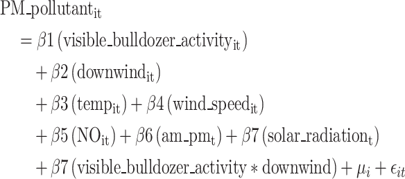
Our final conditional fixed effects linear regression model reflects the following Eq. (1). Simplified versions appearing in the analysis involve the removal of visible bulldozer activity and the interaction term between visible bulldozer activity and downwind.
 |
1 |
where: i indexes the observation unit of location, t indexes time, β1, β2,…, β7 are the coefficients for the independent variables, µi represents the fixed effect for each location, controlling for unobserved heterogeneity, ϵit is the error term. Inclusion of the fixed-effects µi implicitly does the location-specific centering, mitigating effects of unmeasured location-specific confounders (see discussion above).
To assess the consistency of our findings, conditional linear fixed effects regression models were repeated at the 1-minute time scale using two alternative definitions of the downwind angle—one wider and one narrower (Supplemental Results; Figure S2). Additionally, to assess potential variability in our results by proximity of our monitoring sites to the coal terminal, conditional linear fixed effects regression models were repeated at the 1-minute time scale, stratifying the data set by monitoring locations < 0.5 km (Locations 1, 2, 3, 4) versus > 0.5 km (Locations 5, 6, 7, 8, 9, 10) from the coal terminal (Supplemental Results; Tables S3-S6). This stratification by distance balanced our interest to investigate a potential role of proximity while maintaining optimal and similar sample sizes for PM and BC variables in each proximity category. To assess the consistency of results over longer time periods, we calculated stratified mean (SD) concentrations and completed conditional linear fixed-effects regression modeling at 5-, 15-, and 60-minute time scales for PM and BC parameters (Supplemental Results; Figures S4-S6; Tables S8, S10-S15). Finally, all analyses were performed for the measured gases (CO, NO, NO2, & O3) at the 1-, 5-, 15-, and 60-min average time scales (Supplemental Results; Figures S7-S10; Tables S7, S9, S16-S23). The primary analysis of interest was related to airborne PM and BC air pollution related to fugitive dusts, and thus analyses of the gas variables are described in supplementary material. For example, O3 is hypothesized to be a regional pollutant not associated with being downwind of the coal terminal or when visible bulldozer activity was occurring. All analyses were performed using R (version 4.2.3).
Results
Descriptive statistics of meteorological parameters, air pollutants, and visible bulldozer activity
Table 2 summarizes the independent meteorological and trail camera variables at the 1-minute level. Summaries are reflective of deployment times that were not always overlapping in time or season (Figure S1, Table S1) and reflect the availability of non-missing observations for ≥ 1 MODULAIR variables. Mean temperatures ranged from 9.6°C (SD = 7.4) to 17.4°C (SD = 8.3), with relative humidity values averaging between 50.0% (SD = 18.5) and 59.3% (SD = 20.1). Wind speeds demonstrated considerable variation, with means spanning 1.0 mph (SD = 1.3) to 4.2 mph (SD = 3.4). Solar radiation showed high variability, with mean values ranging from 122.9 W/m2 (SD = 201.6) to 213.2 W/m2 (SD = 291.5). The proportion of observations downwind of the coal terminal ranged from 10.3% to 50.0% (Table 2).
Table 2.
Descriptive statistics of meteorological and camera-based observations of any visible bulldozer activity at 1-minute time scale, Curtis Bay, Maryland, U.S., 2022–2023
| Location | |||||||||||
|---|---|---|---|---|---|---|---|---|---|---|---|
| Variable | 1 | 2 | 3 | 4 | 5 | 6 | 7 | 8 | 9 | 10 | |
| Temperature (◦C) | n | 279,422 | 169,163 | 249,332 | 273,630 | 293,032 | 234,965 | 192,655 | 206,228 | 127,688 | 227,279 |
| mean (SD) | 12.7 (8.7) | 11.5 (7.1) | 12.3 (7.3) | 13.9 (8.3) | 13.0 (8.6) | 13.8 (8.6) | 12.8 (8.5) | 9.6 (7.4) | 17.4 (8.3) | 13.2 (9.3) | |
| Relative humidity (%) | n | 279,422 | 169,163 | 249,332 | 273,630 | 293,032 | 234,965 | 192,655 | 206,228 | 127,688 | 227,279 |
| mean (SD) | 58.1 (19.8) | 50.0 (18.5) | 53.0 (9.0) | 53.3 (20.1) | 57.5 (19.9) | 51.3 (18.8) | 51.8 (18.8) | 59.3 (20.1) | 50.4 (19.3) | 58.7 (21.4) | |
| Wind speed (mph) | n | 279,879 | 170,615 | 257,435 | 275,350 | 293,463 | 236,251 | 194,067 | 265,568 | 128,132 | 250,393 |
| mean (SD) | 2.3 (1.7) | 4.2 (3.4) | 1.9 (2.2) | 1.0 (1.3) | 1.0 (3.0) | 1.9 (1.7) | 1.9 (2.8) | 2.4 (2.6) | 3.2 (2.4) | 2.2 (2.3) | |
| Solar radiation (W/m²) | n | 276,460 | 163,539 | 192,205 | 270,042 | 290,286 | 231,121 | 146,384 | 198,879 | 126,542 | 217,491 |
| mean (SD) | 158.0 (244.4) | 147.0 (228.3) | 122.9 (201.6) | 150.5 (235.4) | 158.2 (245.0) | 165.3 (250.7) | 137.6 (216.6) | 127.1 (208.0) | 213.2 (291.5) | 162.8 (251.4) | |
| Downwind of coal terminal (downwind = 1) | n (%) | 87,872 (31.4) | 59,005 (34.6) | 81,341 (31.6) | 102,603 (37.3) | 146,458 (50.0) | 24,358 (10.3) | 34,768 (18.0) | 59,304 (22.3) | 14,960 (11.7) | 47,842 (19.1) |
| Any visible Bulldozer Activity (yes = 1)a | n (%) | 112,088 (40.3) | 78,105 (47.3) | 82,508 (42.6) | 109,349 (40.3) | 118,799 (40.7) | 105,134 (45.2) | 68,373 (46.2) | 81,722 (40.7) | 54,439 (42.9) | 87,592 (39.9) |
| Average number of minutes of visible bulldozer activity per daya |
mean (SD) % of day |
500 (376) 34.8 |
528 (400) 36.6 |
516 (385) 35.8 |
499 (380) 34.7 |
512 (382) 35.6 |
531 (376) 36.9 |
514 (395) 35.7 |
495 (392) 34.4 |
519 (363) 36.0 |
476 (375) 33.1 |
aDescriptive statistics include non-missing observations when ≥ 1 MODULAIR variables occurred concurrently with a trail camera observation
Descriptive statistics for PM (PM1, PM2.5, PM10, and TSP) and BC measured at the 1-minute level are summarized in Table 3. Across all metrics, sample sizes varied by measurement, ranging from 126,630 to 291,318, reflecting differences in data availability by deployment time across locations. Mean concentrations of PM1 ranged from 7.6 µg/m3 (SD = 5.4) to 9.6 µg/m3 (SD = 9.2), and PM2.5 exhibited similar variability, with means between 8.3 µg/m3 (SD = 5.8) and 10.5 µg/m3 (SD = 9.5). Variability in PM10 concentrations increased with mean concentrations ranging from 16.8 µg/m³ (SD = 16.0) to 39.4 µg/m3 (SD = 155.2). Total suspended particulate concentrations showed high variability based on means and standard deviations, with means spanning 24.3 µg/m³ (SD = 113.8) to 67.7 µg/m3 (SD = 479.6).
Table 3.
Descriptive statistics for MODULAIR particulate matter (PM) and DSTech ObservAir black carbon (BC) at the 1-minute time-weighted average, Curtis Bay, Maryland, U.S., 2022–2023
| Location | |||||||||||
|---|---|---|---|---|---|---|---|---|---|---|---|
| Air Pollutant | 1 | 2 | 3 | 4 | 5 | 6 | 7 | 8 | 9 | 10 | |
| PM1 (µg/m3) | n | 277,580 | 164,910 | 193,681 | 271,539 | 291,318 | 219,475 | 138,813 | 200,374 | 126,630 | 218,549 |
| min | 0.04 | 0.05 | 0.07 | 0.04 | 0.07 | 0.07 | 0.05 | 0.09 | 0.05 | 0.08 | |
| mean (SD) | 8.4 (6.5) | 8.2 (6.2) | 9.6 (9.2) | 8.1 (6.1) | 8.0 (6.3) | 8.5 (6.0) | 7.6 (5.4) | 7.7 (5.3) | 8.3 (6.0) | 7.9 (5.6) | |
| max | 417.0 | 266.0 | 449.0 | 265.1 | 342.0 | 70.0 | 94.0 | 164.6 | 112.3 | 132.2 | |
| PM2.5 (µg/m3) | n | 276,357 | 164,774 | 193,328 | 271,435 | 290,949 | 218,957 | 138,663 | 200,134 | 126,630 | 218,280 |
| min | 0.09 | 0.16 | 0.17 | 0.09 | 0.07 | 0.11 | 0.05 | 0.09 | 0.11 | 0.18 | |
| mean (SD) | 9.3 (7.0) | 9.0 (6.6) | 10.5 (9.5) | 8.7 (6.4) | 8.6 (6.5) | 9.5 (6.8) | 8.3 (5.8) | 8.4 (5.5) | 9.2 (6.2) | 8.8 (5.9) | |
| max | 468.0 | 267.0 | 540.1 | 267.9 | 343.6 | 240.9 | 151.7 | 166.2 | 114.6 | 135.1 | |
| PM10 (µg/m3) | n | 276,357 | 164,774 | 193,328 | 271,435 | 290,949 | 218,957 | 138,663 | 200,134 | 126,630 | 218,280 |
| min | 0.14 | 0.25 | 0.17 | 0.14 | 0.07 | 0.12 | 0.13 | 0.09 | 0.17 | 0.22 | |
| mean (SD) | 26.3 (45.5) | 21.3 (38.2) | 28.8 (36.5) | 17.2 (40.6) | 16.8 (16.0) | 39.4 (155.2) | 18.4 (27.9) | 19.9 (19.6) | 23.6 (25.5) | 23.2 (24.4) | |
| max | 5,151.0 | 6,814.4 | 2759.9 | 4663.7 | 2156.7 | 10524.2 | 5236.8 | 473.8 | 1233.6 | 2999.6 | |
| TSP (µg/m3) | n | 276,357 | 164,774 | 193,328 | 271,435 | 290,949 | 218,956 | 138,663 | 200,134 | 126,630 | 218,279 |
| min | 0.14 | 0.25 | 0.17 | 0.14 | 0.07 | 0.12 | 0.13 | 0.09 | 0.17 | 0.22 | |
| mean (SD) | 39.3 (181.0) | 29.4 (112.0) | 43.3 (158.0) | 25.1 (163.6) | 24.3 (113.8) | 67.7 (479.6) | 28.2 (210.0) | 27.9 (139.1) | 38.1 (213.0) | 33.7 (145.8) | |
| max | 22,452 | 13,403 | 12,013 | 16,408 | 20,031 | 138,808 | 60,121 | 19,361 | 23,870 | 19,155 | |
| Black Carbon (µg/m3) | n | 137,432 | 137,239 | -- | -- | 35,072 | -- | -- | 185,754 | -- | -- |
| min | -10.7 | -8.5 | -- | -- | -1.3 | -- | -- | -6.9 | -- | -- | |
| mean (SD) | 1.1 (1.8) | 0.6 (0.7) | -- | -- | 0.6 (0.5) | -- | -- | 0.7 (0.9) | -- | -- | |
| max | 111.8 | 17.0 | -- | -- | 6.2 | -- | -- | 17.2 | -- | -- | |
Note: Sample size determined by available non-missing trail camera data
TSP = total suspended particles
For BC, average concentrations ranged from 0.6 µg/m3 (SD = 0.5) to 1.1 µg/m3 (SD = 1.8). Overall, the independent and dependent data highlight significant spatial and temporal variability in pollutant concentrations and meteorological conditions, indicative of dynamic environmental conditions as well as the varied deployment dates by location.
Visible bulldozer activity was noted in 39.9–47.3% of the data, depending on the time period of data at each location (Table 2). Daily averages for bulldozer activity ranged between 476 min (33.1% of a given 24-hour period) and 531 min (36.9% of a given 24-hour period) (Table 2).
Mean air pollutant concentrations by downwind direction and visible bulldozer activity at coal terminal
As displayed in Fig. 2, mean concentrations of all PM variables were found to be highest during periods when a monitoring site was downwind of the coal terminal and visible bulldozer activity was occurring, and lowest when the site was not downwind of the terminal and there was no visible bulldozer activity occurring. The highest vs. lowest mean (SD) for each pollutant were the following: PM1: 9.4 (7.1) µg/m³ vs. 7.8 (5.9) µg/m³; PM2.5: 10.5 (7.1) µg/m³ vs. 8.5 (5.9) µg/m³; PM10: 27.1 (41.7) µg/m³ vs. 21.9 (56.2) µg/m³; TSP: 40.2 (172.0) µg/m³ vs. 33.4 (193.4) µg/m³; BC: 0.93 (1.60) µg/m³ vs. 0.67 (0.95) µg/m³. Additionally, when bulldozer activity was not present, mean concentrations for all pollutants besides TSP were found to be elevated to their second highest level when monitoring sites were downwind of the coal terminal.
Fig. 2.

One-minute average (standard deviation) concentrations of particulate matter (PM) and black carbon (BC) stratified by wind direction and visible bulldozer activity, Curtis Bay, Baltimore, Maryland, U.S., 2022–2023. Note: Not downwind: Time periods when monitor was not downwind of coal terminal, Downwind: Time periods when monitor was downwind of coal terminal; TSP = total suspended particles
Relation between downwind direction and air pollution burden
Table 4 highlights the sample sizes, mean concentrations, and results from conditional fixed effects linear models to explore the impacts of downwind direction on 1-minute PM1, PM2.5, PM10, TSP, and BC concentrations. There are roughly 2,000,000 records across the ten locations for each of the PM pollutants and over 360,000 records for BC across four locations. The average concentrations (SD) for each pollutant are as follows: PM1: 8.3 (6.4) µg/m³; PM2.5: 9.1 (6.8) µg/m³; PM10: 23.5 (57.8) µg/m³; TSP: 35.6 (215) µg/m³, and BC: 0.76 (1.25) µg/m³. During time periods when a monitor was downwind of the terminal, all PM and BC concentrations were higher, relative to when the monitor was not downwind of the terminal. These increases are highly statistically significant at the p < 0.0001 level. For an example of beta coefficient interpretation for this model, the downwind beta coefficient for PM2.5 is 0.94, meaning the measured PM2.5 concentration was 0.94 µg/m3 higher when a monitor was downwind of the coal terminal versus not downwind (Table 4).
Table 4.
Relation between monitor being downwind of the coal terminal and air pollutant concentration (1-min time scale), Curtis Bay, Maryland, U.S., 2022–2023
| No. of records | Mean of pollutant (SD) | Downwind Beta Coefficienta | 95% CI | t-value | p-value | ||
|---|---|---|---|---|---|---|---|
| PM1(µg/m3) | |||||||
| Downwind of coal terminal (yes = 1; no = 0) | 2,038,915 | 8.3 (6.4) | 0.66 | 0.64, 0.68 | 68.8 | < 0.0001 | |
| PM 2.5 (µg/m 3 ) | |||||||
| Downwind of coal terminal (yes = 1; no = 0) | 2,035,542 | 9.1 (6.8) | 0.94 | 0.92, 0.96 | 93.7 | < 0.0001 | |
| PM 10 (µg/m 3 ) | |||||||
| Downwind of coal terminal (yes = 1; no = 0) | 2,035,542 | 23.5 (57.8) | 4.0 | 3.8, 4.2 | 43.6 | < 0.0001 | |
| TSP (µg/m 3 ) | |||||||
| Downwind of coal terminal (yes = 1; no = 0) | 2,035,541 | 35.6 (215) | 5.3 | 4.6, 6.0 | 15.1 | < 0.0001 | |
| Black Carbon (µg/m 3 ) | |||||||
| Downwind of coal terminal (yes = 1; no = 0) | 361,863 | 0.76 (1.25) | 0.11 | 0.10, 0.12 | 26.4 | < 0.0001 | |
Note. PM = particulate matter; TSP = total suspended particles; SD = standard deviation; CI = confidence interval
aThe beta coefficient is the increase in air pollutant (per µg/m3) when an air monitor was downwind of the coal terminal versus not downwind. Coefficients are derived from conditional fixed effects linear regression models adjusted for temperature (ºC), wind speed (mph), solar radiation (W/m2), NO (ppb), and time of day (AM/PM)
Relation between visible bulldozer activity and air pollution burden
Table 5 depicts the relation between any visible bulldozer activity at the coal terminal and air pollutant levels, stratified by wind direction at a 1-minute timescale. Sample sizes and mean concentrations are the same as those found in Table 4. As suggested by the beta coefficients at the top of each pollutant group, when there is any visible bulldozer activity, there are increases in all pollutant concentrations on average, relative to when there is no visible bulldozer activity. For an example of beta coefficient interpretation for this model, the visible bulldozer activity beta coefficient for PM2.5 is 0.49, meaning the measured PM2.5 concentration was 0.49 µg/m3 higher when visible bulldozer activity was occurring versus when not occurring (Table 5).
Table 5.
Relation between any visible bulldozer activity at the coal terminal and air pollutant levels, stratified by wind direction (1-min time scale), Curtis Bay, Maryland, U.S., 2022–2023
| No. of records | 1-min mean air pollutant (SD) | Visible bulldozer activity beta coefficienta | 95% CI | t-value | p-interaction | |
|---|---|---|---|---|---|---|
| Any visible coal terminal bulldozer activity (yes = 1; no = 0) | ||||||
| PM 1 (µg/m 3 ) b | 2,038,915 | 8.3 (6.4) | 0.40 *** | 0.38, 0.42 | 47.3 | |
| Wind direction (downwind of coal terminal) | 579,645 | 9.0 (6.8) | 0.74*** | 0.71, 0.77 | 45.3 | < 0.0001 |
| Wind direction (not downwind of coal terminal) | 1,459,270 | 8.0 (6.3) | 0.26*** | 0.24, 0.28 | 31.3 | |
| PM 2.5 (µg/m 3 ) b | 2,035,542 | 9.1 (6.8) | 0.49*** | 0.47, 0.50 | 54.8 | |
| Wind direction (downwind of coal terminal) | 578,530 | 10.0 (7.0) | 0.88*** | 0.85, 0.92 | 51.9 | < 0.0001 |
| Wind direction (not downwind of coal terminal) | 1,457,012 | 8.8 (6.6) | 0.32*** | 0.30, 0.34 | 31.3 | |
| PM 10 (µg/m 3 ) b | 2,035,542 | 23.5 (57.8) | 1.3*** | 1.2, 1.5 | 16.2 | |
| Wind direction (downwind of coal terminal) | 578,530 | 25.5 (43.8) | 2.4*** | 2.2, 2.6 | 21.1 | < 0.0001 |
| Wind direction (not downwind of coal terminal) | 1,457,012 | 22.7 (62.5) | 0.9*** | 0.7, 1.1 | 8.6 | |
| TSP (µg/m 3 ) b | 2,035,541 | 35.6 (215) | 2.2*** | 1.6, 2.8 | 7.1 | |
| Wind direction (downwind of coal terminal) | 578,530 | 37.5 (163) | 4.0*** | 3.1, 4.9 | 9.2 | < 0.001 |
| Wind direction (not downwind of coal terminal) | 1,457,011 | 34.8 (233) | 1.5*** | 0.7, 2.3 | 3.8 | |
| Black carbon (µg/m 3 ) c | 361,863 | 0.77 (1.25) | 0.09*** | 0.08, 0.10 | 25.0 | |
| Wind direction (downwind of coal terminal) | 112,098 | 0.88 (1.32) | 0.14*** | 0.12, 0.15 | 18.6 | < 0.0001 |
| Wind direction (not downwind of coal terminal) | 249,765 | 0.72 (1.22) | 0.07*** | 0.06, 0.08 | 17.3 | |
aThe beta coefficient is the increase in air pollutant (per µg/m3) when any bulldozer activity was versus was not observed. Coefficients are derived from conditional fixed effects linear regression models adjusted for temperature (ºC), wind speed (mph), solar radiation (W/m2), NO (ppb), and time of day (AM/PM)
bModels include data from air monitoring locations 1 through 10
cModels include data from air monitoring locations 1, 2, 5, and 8
*p-value < 0.05, **p-value < 0.01, ***p-value < 0.001
Note. PM = particulate matter; TSP = total suspended particles; SD = standard deviation; CI = confidence interval
Joint association of downwind direction and bulldozer activity with air pollution burden
In Table 5, when there is any visible bulldozer activity at the coal terminal versus not, mean concentrations of all PM pollutants and BC are statistically significantly higher (all p < 0.001). Further, the bulldozer activity–air pollutant (PM1, PM2.5, PM10, TSP, and BC) association was larger for when an air monitor was downwind of the terminal relative to when not downwind of the terminal (all p-interaction < 0.0001). In the wind direction-stratified analysis, for all pollutants in Table 5, when the monitor was downwind of the terminal, beta coefficients were roughly two to three times higher during downwind versus not downwind stratified time periods. Figure 3 visually represents the beta coefficients from the pooled, non-downwind, and downwind results described in Sect. 3.4 and 3.5.
Fig. 3.

Forest plot showing magnitude of beta coefficient and 95% confidence interval (CI) estimates of the relation between any visible bulldozer activity at the coal terminal and changes in PM1, PM2.5, PM10, total suspended particles (TSP) and black carbon (BC) stratified by time periods that were downwind of the coal terminal versus not at 1-minute average time intervals, Curtis Bay, Baltimore, Maryland, U.S., 2022–2023. Note. Binary any visible bulldozer activity versus none was defined as: If a 1-minute time period had any visible bulldozer activity = 1; if a 1-minute time period did not have any visible bulldozer activity = 0. All p-interaction < 0.001 for PM1, PM2.5, and PM10, TSP, and BC. Coefficient = Beta coefficient of conditional fixed effects linear regression model for the relation between any visible bulldozer activity at the coal terminal and air pollutant levels
Discussion
This study demonstrated increased PM and BC air pollution burden in a community bordering a coal storage, handling, and export terminal which was related to time-varying patterns of wind direction and visible bulldozer activity at the terminal. Further, when both occurred jointly–i.e., during time periods when the monitoring site was downwind of the coal terminal and there was visible bulldozer activity–PM and BC air pollution burden was greatest. We used an effect measure modification analysis approach to understand evidence of statistical interaction, which demonstrated strong consistency in terms of the direction, order of magnitude, and precision of joint effect estimates across a range of transient time scales (1-, 5-, 15-, 60 min; Supplementary Results). The incorporation of NO as a control for local combustion and / or diesel exhaust from the bulldozers also enhanced the ability of the analysis to isolate the relationships of interest related to windblown dust.
Dust sources present particle size distributions that may be uni- or bi-modal, with tailing that extends into the finer particle sizes (Junge 1955; Brahney et al. 2024; Chalvatzaki et al. 2012; Seinfeld and Pandis 2006). Although the mode for the diameter of coal dust is ~ 10 μm, a substantial fraction of the particles fall in the respirable range under 2.5 μm. Coal dust, like wind-blown dust in general, follows a Gaussian, log-normal distribution (Junge 1955):
 |
2 |
where N is the number of particles, r is their radius, C is a constant, and  is a constant ~ 3 in the classic Junge distribution (Junge 1955). This theory has been experimentally verified for coal and is described in textbooks (Barone et al. 2019; Seinfeld and Pandis 2006; Tessum and Raynor 2017). The large particles will fall out of the atmosphere rapidly, with a settling velocity corresponding to a transport distance of ~ 1 km, however, smaller particles will persist until rained out in ~ 1 week (Seinfeld and Pandis 2006). It is thus noteworthy that we observed consistency of associations not only for coarse PM10 and TSP, but also for PM1 and PM2.5. Smaller size fraction PM, like PM1 and PM2.5, are pollutants typically associated with regional pollution, traffic, and combustion, while BC is also associated with traffic emissions. Consistency of associations with smaller PM and BC with downwind bulldozer activity may suggest that BC measurements alone or in combination with PM may have utility for identifying black PM air pollution, like coal dust, more broadly in communities bordering coal storage, handling, and export facilities. Black carbon monitors’ measurement methods select for fine mode aerosol while coal dust is generally coarse mode so future efforts should include speciated PM10 or TSP.
We employed a fixed effects regression modeling approach which cannot be confounded by factors that do not vary at the same time scale as the temporal scale of the exposure-response being investigated. The results of this regression modeling approach for PM1, PM2.5, PM10, TSP and BC support the hypothesis that mean concentrations of these air pollutants are higher when the winds blow toward monitoring locations downwind from the coal terminal. The statistical methodology adopted has certain limitations. When only considering downwind wind direction as the exposure, there is a chance of potential confounding from another source of pollution coming from the same direction as the coal terminal. This confounding risk is mitigated to a large extent when using the visible bulldozer activity data as the exposure as it is unlikely that there is another temporal confounder that is highly concurrent with bulldozer activity, particularly as we control for local combustion and / or diesel exhaust from the bulldozer activity. The assumption of linearity in the fixed effect models used can also be violated. The current analysis also only offers an average effect size based on pooled data from all ten air monitoring sites. Separate site-specific analysis can reveal variability in these effect sizes and how they relate to distance from the coal terminal.
Our focus on transient exposure-response time scales reflects the community lived experience involving reports of frequent short term dust events that recur frequently (analogous to our 1-min, 5-min, and 15-min time scales) as well as longer events that have been documented (analogous to our 60-min time scale). Curtis Bay community members recently documented an example of a longer high visibility fugitive dust event at the coal terminal which lasted for approximately 30 min (Shen 2024; South Baltimore Community Land Trust (SBCLT), 2024). The consistency of our exposure-response associations across all times scales considered (1-min, 5-min, 15-min, and 60-min) for both explanatory variables (downwind of the coal terminal and visible bulldozer activity) and all PM and BC air pollutants (Figs. 3, S4-S6; Table S8) is coherent with neighbors’ reports about the nature of fugitive dust events.
To our knowledge, this study is the first to investigate the relation between wind direction and coal terminal activity upon the air pollution burden in a proximal fenceline community. This study has some limitations including TSP measurements by moderate-cost sensors do not have a convenient reference comparator for validation and calibration, unlike PM2.5, PM10, and BC. Observed variation in TSP values with large standard deviations may be attributed to instrument error or natural variability due to the higher settling velocity of larger particles resulting in spatial heterogeneity on scales of ~ 100 m. In the coding of trail camera data, tree foliage inhibited the identification of bulldozer activity on certain coal piles during certain times of year. During these times, if there was no bulldozer activity at visible coal piles, the observation was coded as no activity “0” rather than missing “.”. We hypothesize that this could have led to an underestimate of the true extent of bulldozer activity that was occurring on the coal piles during these tree foliage-impacted times of year. However, this potential misclassification of bulldozer activity was likely non-differential with respect to the outcome (air pollution).
Our study also has several notable strengths. Our research questions were informed by the concerns, observations, and experiences of Curtis Bay community members who have lived proximal to the coal terminal for decades. This guided our analytic approach involving conditional fixed-effects regression modeling of multi-pollutant data. Thereby, we controlled for time-invariant characteristics of each location, such as proximity to pollution sources or local infrastructure, which could otherwise confound our observed association. By focusing on within-monitor variation in air pollutants over time, fixed-effects models isolated the effects of wind direction and visible bulldozer activity while removing the potential influence of location-specific non-time varying factors. Another strength is the use of the MODULAIR multi-pollutant air sensor which monitors dust in multiple particle size bins. This may be used for quality control to improve confidence in results– i.e., temporal patterns observed in multiple, independent channels are more realistic in mixed urban/industrial environments than a unique signal in a discrete particle size bin.
Future directions for this line of research could extend the conditional fixed effects regression modeling approach to other time-resolved activity patterns at the coal terminal. While our analysis focused on visible bulldozer activity due to its association with general terminal operations, future analyses can be extended to code time-resolved activity patterns of coal transport by trains, coal ship / barge activity, coal pile height, and use of the dust wet suppression system. Additionally, the conditional fixed-effects regression modeling approach used assumes a linear relationship, and future studies could explore other non-linear approaches, assess and account for potential unmeasured temporal confounding and lags. Our preliminary analysis of how air quality burden varies with proximity of the measurement sites to the coal terminal could be expanded to investigate location-specific and other spatial patterns. Further, there are opportunities for source attribution analyses to identify combinations of air pollutants that are associated with coal terminal emissions.
Short-term exposure to PM has been increasingly linked to adverse health outcomes, with more research still needed (Gutiérrez-Avila et al. 2023; Orellano et al. 2020). Fine PM (PM1 and PM2.5) are of particular concern due to their ability to penetrate deep into the respiratory tract and enter the bloodstream, exacerbating cardiovascular and respiratory conditions. Acute exposure to PM10 has been associated with increased hospital admissions for asthma, bronchitis, and chronic obstructive pulmonary disease (COPD), as well as heightened risks of stroke and cardiac events (Alessandrini et al., 2016, Orellano et al. 2020). These impacts are particularly pronounced in vulnerable populations such as children, the elderly, and individuals with pre-existing health conditions. Both long-term and acute exposure to BC have been linked to morbidity and mortality due to cardiovascular and respiratory disease (Song et al. 2022; Luben et al. 2017; Hvidtfeldt et al. 2019; Ostro et al. 2015; Janssen and Joint 2012), in addition to marked impacts upon fetal, pediatric, and maternal health outcomes (Paunescu et al. 2019; Goriainova et al. 2022). Residents in communities of color and low wealth are also disproportionately exposed to PM, BC, and other forms of air pollution, experience elevated impacts of this pollution, and are often overburdened by the cumulative impacts of other chemical and non-chemical stressors. Higher PM2.5 exposure was also observed for Hispanic and Black residents in San Francisco, CA living near uncovered coal by rail transport infrastructure(Ostro et al. 2024).
Community observations, actions taken by state/local governments, and the results of this research suggest additional measures are warranted to end or mitigate fugitive dust emissions related to coal terminal operations and neighborhood health and quality of life impacts associated with such emissions. Currently, the facility maintains a wet dust suppression system and has a partial porous wind fence at the southern edge of the coal terminal. When restricting our analysis to the one location within the network on the opposite side of the wind fence, our results were generally consistent with the analysis that pooled data across all locations. This suggests that off-site community air pollution burden is not reduced by wind screen netting mitigation strategies. A range of additional strategies have been submitted by community members. These include, but are not limited to: (1) denial of the application for the renewal of its operating permit based on a record of complaints and violations; (2) full enclosure of the coal piles paired with enforceable limits on PM from the terminal; (3) the imposition of fees on a per-ton basis of coal transferred through the terminal to mitigate negative externalities; and (4) transitioning to the storage and handling of a safer material at the facility.
Conclusions
The findings of this study demonstrated higher PM and BC air pollution burden in Curtis Bay when downwind of the coal terminal and when there was visible bulldozer activity–highest air pollution burdens were observed when both occurred jointly. Results are consistent with the lived experiences of Curtis Bay community members who have documented ongoing, repeated patterns of black dust accumulation at and around their homes alongside recordings of transient fugitive black dust plumes at the coal terminal. Further context for our findings is provided by a recent study demonstrating the detection of coal dust in the black dust that accumulates in residential and community spaces of the Curtis Bay neighborhood (Aubourg et al. 2024). Overall, our findings in context with complementary research and community experiences contribute to a coherence of data across varied analytical and observational platforms that respond to residents’ questions and concerns with dark dust accumulation in Curtis Bay. Compared to both Baltimore City and the State of Maryland, the Curtis Bay community is overburdened by cumulative impacts of economic hardship, high vacancy rates, historical pollution burden, and health disparities such as higher mortality due to chronic obstructive pulmonary disease and lung cancer (Baltimore City Health Department 2017). Strategies to mitigate the observed air pollution burdens in the Curtis Bay community appear warranted, including those that could prevent windblown and mechanical dusts that might be associated with operating practices at the coal terminal.
Electronic supplementary material
Below is the link to the electronic supplementary material.
Acknowledgements
We thank the Curtis Bay residents, local business owners, and faith-based organizations who trusted our team, contributed their lived experiences and knowledge, and hosted air quality monitors and / or trail cameras. We thank the students in the environmental justice class at Benjamin Franklin High School for their engagement and enthusiasm. We thank the Maryland Department of the Environment Air and Radiation Administration for their technical support and collaboration. We thank Anna Hodshire and Eben Cross from QuantAQ and Troy Cados, Julien Caubel, and Nick Wong from Distributed Sensing Technologies for their scientific guidance and technical support.
Author contributions
Lauren N. Deanes: Conceptualization, Data curation, Formal analysis, Funding acquisition, Investigation, Methodology, Software, Visualization, Writing– original draft, Writing– review & editing; Bonita D. Salmerón: Conceptualization, Data curation, Formal analysis, Investigation, Methodology, Software, Visualization, Writing– original draft, Writing– review & editing; Matthew A. Aubourg: Conceptualization, Formal analysis, Investigation, Methodology, Project administration, Supervision, Visualization, Writing– original draft, Writing– review & editing; Laura E. Schmidt: Investigation, Project administration, Writing– original draft, Writing– review & editing; Kristoffer Spicer: Conceptualization, Investigation, Project administration, Supervision, Writing– review & editing; Caila Wagar: Investigation, Data curation, Writing– review & editing; Gregory G. Sawtell: Conceptualization, Investigation, Methodology, Project administration, Supervision, Writing– original draft, Writing– review & editing; Carlos C. Sanchez-Gonzalez: Conceptualization, Investigation, Writing– review & editing; David Jones: Conceptualization, Investigation, Writing– review & editing; Angela Shaneyfelt: Conceptualization, Investigation, Writing– review & editing; David H. Hagan: Data curation, Formal analysis, Methodology, Resources, Software, Writing– review & editing; David McClosky: Data curation, Formal analysis, Methodology, Software, Writing– review & editing; Nicholas J. Spada: Formal analysis, Writing– review & editing; Russell R. Dickerson: Formal analysis, Investigation, Methodology, Supervision, Writing– review & editing; Vivek Ravichandran: Conceptualization, Investigation, Writing– review & editing; Sacoby M. Wilson: Conceptualization, Investigation, Project administration, Resources, Supervision, Writing– review & editing; Anik Burman: Formal analysis, Methodology, Writing– review & editing; Abhirup Datta: Formal analysis, Methodology, Supervision, Visualization, Writing– review & editing; Christopher D. Heaney: Conceptualization, Data curation, Formal analysis, Funding acquisition, Investigation, Methodology, Project administration, Resources, Software, Supervision, Writing– original draft, Writing– review & editing.
Funding
This work was supported by the National Institute of Environmental Health Sciences (NIEHS) P30 Center for Community Health: Addressing Regional Maryland Environmental Determinants of Disease (CHARMED) [grant no. P30ES032756]. BS, MAA, LS, KS, and CDH were supported by the Johns Hopkins Community Science and Innovation for Environmental Justice (CSI EJ) Initiative. MAA and CDH were supported by NIEHS grant no. P30ES032756. KS and CDH were supported by the National Institute for Occupational Safety and Health (NIOSH) Education and Research Center [grant no. T42OH0008428]. LD was supported by NIEHS Training Program in Environmental Health Sciences [grant no. T32ES007141]. NJS was supported by the UC Davis Environmental Health Science Center Core [grant no. P30ES023513]. RRD was supported by the University of Maryland Challenge Grant and the Maryland Department of the Environment. AB and AD were supported by NIEHS grant no. R01ES033739. RRD, VR, SMW, and the Community of Curtis Bay Association (CCBA) were supported by the U.S. Environmental Protection Agency (EPA) American Rescue Plan Enhanced Air Quality Monitoring for Communities (EPA-OAR-OAQPS-22-01) [grant no. U00P4600952].
Data availability
De-identified data will be made available upon request.
Declarations
Ethics approval and consent to participate
This study was reviewed and determined to be not human subjects research (NHSR) by the Johns Hopkins Bloomberg School of Public Health Institutional Review Board (IRB).
Consent for publication
Not applicable.
Competing interests
MAA serves as an unpaid member of the board of directors of the South Baltimore Community Land Trust (SBCLT), starting on June 24, 2024. The other authors declare that they have no known competing financial interests or personal relationships that could have appeared to influence the work reported in this paper.
Footnotes
Publisher’s note
Springer Nature remains neutral with regard to jurisdictional claims in published maps and institutional affiliations.
Lauren N. Deanes and Bonita D. Salmerón contributed equally to this work.
Contributor Information
Matthew A. Aubourg, Email: maubour1@jh.edu
Christopher D. Heaney, Email: cheaney1@jhu.edu
References
- Alessandrini ER, Stafoggia M, Faustini A, Berti G, Canova C, De Togni A, Di Biagio K, Gherardi B, Giannini S, Lauriola P, Pandolfi P, Randi G, Ranzi A, Simonato L, Sajani Z, Cadum S, Forastiere E, F., Group O B. O. T. E. S. 2016. Association between Short-Term exposure to PM2.5 and PM10 and mortality in susceptible subgroups: A multisite Case-Crossover analysis of individual effect modifiers. Am J Epidemiol, 184, 744–754 [DOI] [PubMed]
- Allison PD (2009) Fixed effects regression models. SAGE
- Aubourg MA, Sawtell G, Deanes L, Fabricant N, Thomas M, Spicer K, Wagar C, Campbell S, Ulman A, Heaney CD (2023) Community-driven research and capacity building to address environmental justice concerns with industrial air pollution in Curtis Bay, South Baltimore. Front Epidemiol 3:1198321 [DOI] [PMC free article] [PubMed]
- Aubourg MA, Livi KJT, Sawtell GG, Sanchez-Gonzalez CC, Spada NJ, Dickerson RR, Chiou W, Kamanzi C, Ramachandran G, Rule AM, Heaney CD (2024) Use of electron microscopy to determine presence of coal dust in a neighborhood bordering an open-air coal terminal in Curtis Bay, Baltimore, Maryland, USA. Sci Total Environ 176842 [DOI] [PMC free article] [PubMed]
- Baltimore City Health Department (2017) Baltimore City 2017 Neighborhood Health Profile: Brooklyn/Curtis Bay/Hawkins Point [Online]. Available: https://health.baltimorecity.gov/sites/default/files/NHP%202017%20-%2004%20Brooklyn-Curtis%20Bay-Hawkins%20Point%20(rev%206-9-17).pdf [Accessed Jun 1 2024]
- Barone TL, Hesse E, Seaman CE, Baran AJ, Beck TW, Harris ML, Jaques PA, Lee T, Mischler SE (2019) Calibration of the cloud and aerosol spectrometer for coal dust composition and morphology. Adv Powder Technol 30:1805–1814 [Google Scholar]
- Brahney J, Heindel RC, Gill TE, Carling G, González-Olalla JM, Hand J, Mallia DV, Munroe JS, Perry K, Putman AL, Skiles SM, Adams BR, Aanderud Z, Aarons S, Aguirre D, Ardon-Dryer K, Blakowski MB, Creamean JM, Fernandez D, Foroutan H, Gaston C, Hahnenberger M, Hoch S, Jones DK, Kelly KE, Lang OI, Lemonte J, Reynolds R, Singh RP, Sweeney M, Merrill T (2024) Dust in the critical zone: North American case studies. Earth Sci Rev 258:104942 [Google Scholar]
- Cassie R (2024) Ashes to Ashes, Dust to Dust [Online]. Baltimore Magazine. Available: https://www.baltimoremagazine.com/section/health/curtis-bay-south-baltimore-air-pollution-coal-incineration-public-health-impacts/ [Accessed Dec 10 2024]
- Chalvatzaki E, Aleksandropoulou V, Glytsos T, Lazaridis M (2012) The effect of dust emissions from open storage piles to particle ambient concentration and human exposure. Waste Manag 32:2456–2468 [DOI] [PubMed] [Google Scholar]
- Community Of Curtis Bay Association (CCBA) (2023) Call for Declaration of Air Pollution Emergency in Curtis Bay [Online]. Available: https://ilovecurtisbay.com/2023/05/19/call-for-declaration-of-air-pollution-emergency-in-curtis-bay/ [Accessed Dec 10 2024]
- Cortes-Ramirez J, Naish S, SLY PD, Jagals P (2018) Mortality and morbidity in populations in the vicinity of coal mining: a systematic review. BMC Public Health 18:721 [DOI] [PMC free article] [PubMed] [Google Scholar]
- CSX Corporation Curtis Bay Coal Piers in Baltimore, MD [Online]. Available: https://www.csx.com/index.cfm/customers/commodities/coal/terminals/curtis-bay-coal-piers-in-baltimore-md/ [Accessed Jun 01 2024]
- Dickerson RR, Stratton P, Ren X, Kelley P, Heaney C, Deanes L, Aubourg M, Spicer K, Dreessen J, Auvil R, Sawtell G, Thomas M, Campbell S, Sanchez C (2024) Mobile laboratory measurements of air pollutants in Baltimore, MD elucidate issues of environmental justice. J Air Waste Manag Assoc 74(11):753–770 [DOI] [PMC free article] [PubMed]
- U.S. Energy information administration (EIA) (2024) What are the energy impacts from the Port of Baltimore closure? [Online]. Available: https://www.eia.gov/todayinenergy/detail.php?id=61663# [Accessed Jun 19 2024]
- Environmental Integrity Project (2012) Air Quality Profile Of Curtis Bay, Brooklyn and Hawkins Point, Maryland [Online]. Available: https://www.environmentalintegrity.org/wp-content/uploads/2016/11/2012-06_Final_Curtis_Bay.pdf [Accessed Dec 10 2024]
- Fabricant N (2023) Fighting to breathe: race, toxicity, and the rise of youth activism in Baltimore. University of California Press
- Goriainova V, Awada C, Opoku F, Zelikoff JT (2022) Adverse effects of black carbon (BC) exposure during pregnancy on maternal and fetal health: A contemporary review. Toxics [Online], 10 [DOI] [PMC free article] [PubMed]
- Gutiérrez-Avila I, Riojas-Rodríguez H, Colicino E, Rush J, Tamayo-Ortiz M, Borja-Aburto VH, Just AC (2023) Short-term exposure to PM2.5 and 1.5 million deaths: a time-stratified case-crossover analysis in the Mexico City metropolitan area. Environ Health 22:70 [DOI] [PMC free article] [PubMed] [Google Scholar]
- Hagan D (2024) Evaluating the Performance of the MODULAIR-PM Particulate Matter Sensor in Jurupa Valley, CA [Online]. Available: https://zenodo.org/records/11200301 [Accessed Dec 10 2024]
- Hagan D, Mcclosky D (2024) Identifying and removing data records influenced by Fog [Online]. Available: https://zenodo.org/records/10793534 [Accessed Dec 10 2024]
- Hendryx M (2015) The public health impacts of surface coal mining. Extractive Industries Soc 2:820–826 [Google Scholar]
- Hendryx M, Entwhistle J (2015) Association between residence near surface coal mining and blood inflammation. Extractive Industries Soc 2:246–251 [Google Scholar]
- Hendryx M, Islam MS, Dong G-H, Paul G (2020a) a. Air pollution emissions 2008–2018 from Australian coal mining: implications for public and occupational health. International J Environ Res Public Health [Online], 17 [DOI] [PMC free article] [PubMed]
- Hendryx M, Zullig KJ, Luo J (2020b) Impacts of coal use on health. Annu Rev Public Health 41:397–415 [DOI] [PubMed] [Google Scholar]
- Hvidtfeldt UA, Sørensen M, geels C, Ketzel M, Khan J, Tjønneland A, Overvad K, Brandt J, Raaschou-Nielsen O (2019) Long-term residential exposure to PM2.5, PM10, black carbon, NO2, and Ozone and mortality in a Danish cohort. Environ Int 123:265–272 [DOI] [PubMed] [Google Scholar]
- International Energy Agency (IEA) (2023) Coal 2023: Analysis and forecast to 2026 [Online]. Available: https://iea.blob.core.windows.net/assets/a72a7ffa-c5f2-4ed8-a2bf-eb035931d95c/Coal_2023.pdf [Accessed Jun 06 2024]
- Janssen NA, Joint W (2012) Health effects of black carbon. WHO Regional Office for Europe Copenhagen
- Junge C (1955) The size distribution and aging of natural aerosols as determined from electrical and optical data on the atmosphere. J Atmos Sci 12:13–25 [Google Scholar]
- Kazanjian G (2022) CSX coal explosion impacted a large swath of residential Curtis Bay, report finds [Online]. Baltimore Brew. Available: https://baltimorebrew.com/2022/08/27/csx-coal-explosion-impacted-a-large-swath-of-residential-curtis-bay-report-finds/ [Accessed March 06 2024]
- Kurth LM, Mccawley M, Hendryx M, Lusk S (2014) Atmospheric particulate matter size distribution and concentration in West Virginia coal mining and non-mining areas. J Expo Sci Environ Epidemiol 24:405–411 [DOI] [PubMed] [Google Scholar]
- Liu T, Liu S (2020) The impacts of coal dust on miners’ health: A review. Environ Res 190:109849 [DOI] [PubMed] [Google Scholar]
- Luben TJ, Nichols JL, Dutton SJ, Kirrane E, Owens EO, Datko-Williams L, Madden M, Sacks JD (2017) A systematic review of cardiovascular emergency department visits, hospital admissions and mortality associated with ambient black carbon. Environ Int 107:154–162 [DOI] [PMC free article] [PubMed] [Google Scholar]
- Maryland department of the environment (2022) RE: Notice of Violation– December 30, 2021 Curtis Bay Terminal Coal Explosion [Online]. Available: https://mde.maryland.gov/Documents/CSX%20NOV%20Coal%20Explosion%20-%20July%2020%202022.pdf [Accessed Dec 10 2024]
- Mcclosky D, Hagan D (2024) Evaluating MODULAIR gas measurements against EPA Air Sensor Performance Targets [Online]. Available: https://zenodo.org/records/14456513 [Accessed Dec 10 2024]
- Orellano P, Reynoso J, Quaranta N, Bardach A, Ciapponi A (2020) Short-term exposure to particulate matter (PM10 and PM2.5), nitrogen dioxide (NO2), and Ozone (O3) and all-cause and cause-specific mortality: systematic review and meta-analysis. Environ Int 142:105876 [DOI] [PubMed] [Google Scholar]
- Ostro B, Tobias A, Karanasiou A, Samoli E, Querol X, Rodopoulou S, Basagaña X, Eleftheriadis K, Diapouli E, Vratolis S, Jacquemin B, Katsouyanni K, Sunyer J, Forastiere F, Stafoggia M (2015) The risks of acute exposure to black carbon in Southern europe: results from the MED-PARTICLES project. Occup Environ Med 72:123 [DOI] [PubMed] [Google Scholar]
- Ostro B, Spada N, Kuiper H (2023a) Assessment of Coal and Petroleum Coke Pollution: Air Quality, Health, and Environmental Justice
- Ostro B, Spada N, Kuiper H (2023b) The impact of coal trains on PM2.5 in the San Francisco Bay area. Air Qual Atmos Health 16:1173–1183 [DOI] [PMC free article] [PubMed] [Google Scholar]
- Ostro B, Fang Y, Sospedra MC, Kuiper H, Ebisu K, Spada N (2024) Health impact assessment of PM2.5 from uncovered coal trains in the San Francisco Bay area: implications for global exposures. Environ Res 252:118787 [DOI] [PMC free article] [PubMed] [Google Scholar]
- Paunescu A-C, Casas M, Ferrero A, Pañella P, Bougas N, Beydon N, Just J, Lezmi G, Sunyer J, Ballester F, Momas I (2019) Associations of black carbon with lung function and airway inflammation in schoolchildren. Environ Int 131:104984 [DOI] [PubMed] [Google Scholar]
- Petsonk EL, Rose C, Cohen R (2013) Coal mine dust lung disease. New lessons from an old exposure. Am J Respir Crit Care Med 187:1178–1185 [DOI] [PubMed] [Google Scholar]
- Seinfeld JH, Pandis SN (2006) Atmospheric chemistry and physics: from air pollution to climate change. Wiley, New York [Google Scholar]
- Shekarian Y, Rahimi E, Rezaee M, Roghanchi P (2023) A systematic review of occupational exposure to respirable coal mine dust (RCMD) in the U.S. Mining industry. Int J Coal Sci Technol 10:29 [Google Scholar]
- Shen F (2024) Community irate over latest coal dust storm at CSX Curtis Bay facility [Online]. Baltimore Brew. Available: https://www.baltimorebrew.com/2024/09/09/community-irate-over-latest-coal-dust-storm-at-csx-curtis-bay-facility/ [Accessed Dec 09 2024]
- Song X, Hu Y, Ma Y, Jiang L, Wang X, Shi A, Zhao J, Liu Y, Liu Y, Tang J, Li X, Zhang X, Guo Y, Wang S (2022) Is short-term and long-term exposure to black carbon associated with cardiovascular and respiratory diseases? A systematic review and meta-analysis based on evidence reliability. BMJ Open 12:e049516 [DOI] [PMC free article] [PubMed] [Google Scholar]
- South Baltimore Community Land Trust (2023) Coal Explosion in Curtis Bay [Online]. Available: https://www.youtube.com/watch?v=JaSRxe4h8J8 [Accessed Mar 06 2024]
- South Baltimore Community Land Trust (SBCLT) (2024) Another massive coal dust event at CSX terminal next to community center and park [Online]. Available: https://www.youtube.com/watch?v=7eudBwa-6RY [Accessed Dec 09 2024]
- Tessum MW, Raynor PC (2017) Effects of spray surfactant and particle charge on respirable coal dust capture. Saf Health Work 8:296–305 [DOI] [PMC free article] [PubMed] [Google Scholar]
Associated Data
This section collects any data citations, data availability statements, or supplementary materials included in this article.
Supplementary Materials
Data Availability Statement
De-identified data will be made available upon request.