Abstract
A characteristic feature of most Arctic regions is the many shallow ponds that dot the landscape. These surface waters are often hotspots of biodiversity and production for microorganisms, plants, and animals in this otherwise extreme terrestrial environment. However, shallow ponds are also especially susceptible to the effects of climatic changes because of their relatively low water volumes and high surface area to depth ratios. Here, we describe our findings that some high Arctic ponds, which paleolimnological data indicate have been permanent water bodies for millennia, are now completely drying during the polar summer. By comparing recent pond water specific conductance values to similar measurements made in the 1980s, we link the disappearance of the ponds to increased evaporation/precipitation ratios, probably associated with climatic warming. The final ecological threshold for these aquatic ecosystems has now been crossed: complete desiccation.
Keywords: climatic change, desiccation, environmental change, limnology
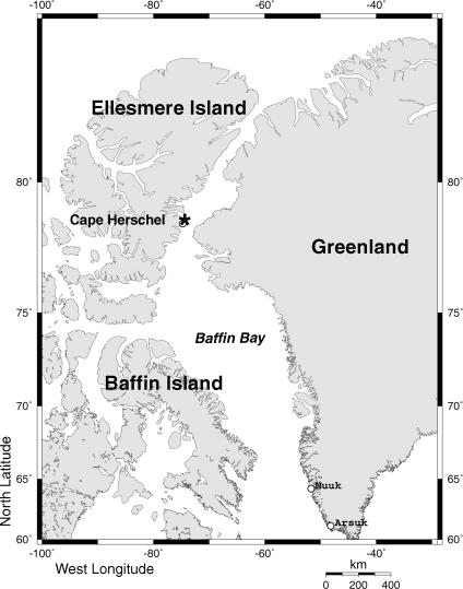
The effects of climatic change are expected to be greatly amplified in polar regions because of various positive feedback mechanisms (1). However, because long-term monitoring data are generally lacking, little is known about the ecological repercussions of recent warming. In an attempt to determine the nature and magnitude of environmental changes in these high-latitude, climatically sensitive regions, we have been systematically monitoring a suite of study ponds on Cape Herschel (78°37′N, 74°42′W; Ellesmere Island, Nunavut, Canada; Fig. 1). We used identical techniques (2, 3) to collect detailed limnological data from the ponds in the summers of 1983, 1984, 1986, 1987, 1995, 1998, 2001, 2004, and 2006. Additional observations were available from other scientists working at Cape Herschel since the 1970s (3). Collectively, these data represent the longest record of systematic limnological monitoring from the high Arctic.
Fig. 1.
Map showing the location of Cape Herschel (*) on the east coast of Ellesmere Island. Locations and further details regarding the ponds are described in ref. 2.
In this paper, we summarize over two decades of limnological observations and dovetail these records with our paleolimnological studies. Using these data, we show that some high Arctic pond ecosystems, which represent the most common aquatic habitat in many polar regions, have desiccated as a consequence of climate change, i.e., increasing evaporation/precipitation (E/P) ratios.
Results and Discussion
Over the 24-year monitoring window covered by our detailed surveys, we recorded evidence of recent lower water levels and changes in water chemistry data (e.g., increased specific conductance) consistent with increased E/P and warmer temperatures. Until recently, our study sites were permanent features of the landscape, as they contained water until freeze-up in September. However, a major threshold was crossed, associated with the most recent warming trends in the Arctic, because, by early July 2006, several of our main study ponds had dried up, whereas others had very much reduced water levels.
The Cape Herschel study sites, many of which have existed for millennia (4, 5), are typical of most high Arctic ponds. The basins of most of the Cape Herschel ponds are underlain by granitic bedrock. In contrast, the temporary thermokarst ponds, which characterize many Subarctic regions, are underlain by relatively thick, unconsolidated material, and therefore are highly variable systems, where changes in permafrost may profoundly influence water-level changes (6). Consequently, water levels in ponds such as those at Cape Herschel are not similarly influenced by permafrost drainage and represent a more direct link to important atmospheric variables, such as temperature and precipitation.
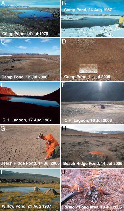
The desiccation of small, shallow sites is certainly of ecological and environmental significance; however, what is especially worrisome is that many of the disappearing ponds are of considerable size. For example, one of our main sampling sites (2–5) is Camp Pond (Fig. 2 A–D). During earlier periods of higher water levels (i.e., the 1970s and 1980s), it typically had dimensions of >20 m × 40 m (Fig. 2 A and B) and even larger during wetter years, yet it was completely dry by July 12, 2006 (Fig. 2C). Cape Herschel Lagoon, a substantial water body of ≈160 m × 35 m and >1 m deep in the 1980s (Fig. 2E), had only a small shallow puddle of water (23 m × 11 m, and ≈10 cm deep) left in one basin when we sampled it on July 13, 2006 (Fig. 2F). Beach Ridge Pond, whose former dimensions reached ≈100 m × 60 m, had already completely dried up by July 8, 2006 (Fig. 2 G and H), the date of our arrival (although following 2 days of rain in later July, a small puddle reformed). Had these ponds dried up in late August or early September (i.e., by the end of the typical ice-free season), this would in itself be an important ecological threshold. However, what is especially striking about these observations is that some of the ponds dried up at such an early point in the summer (beginning of July). Based on data from thermistors we had deployed in some of the ponds in 2004, the ponds similarly evaporated in July 2005, a year when we were not at Cape Herschel. We know this because the thermistor recorders that we had deployed in the centers of Camp and Beach Ridge ponds (in 2004) began to register identical temperatures to the thermistors deployed on the nearby land by July 2005, a clear indication that the ponds had dried up.
Fig. 2.
Photographs of the Cape Herschel ponds, showing the marked changes in water levels and associated ecological effects. (A) Photograph of Camp Pond taken on July 14, 1979 (photo courtesy of W. Blake, Jr). The water levels are so high that some of the surrounding land is also flooded with small pools. (B) Camp Pond on Aug. 24, 1987, at the end of the field season, when the winter snows had already returned to Cape Herschel. Note that the pond, even this late in the field season, is still a large, permanent body of water. (C) Camp Pond on July 12, 2006, just hours before it dried completely. (D) The aquatic invertebrates (with the fairy shrimp, B. paludosa, as the last survivors) concentrated in the remaining puddle left in Camp Pond, the day before it desiccated totally. (E) One of the basins of Cape Herschel Lagoon on Aug. 17, 1987. Although late in the field season, the pond was still a large, permanent body of water. (F) The desiccated basin of Cape Herschel Lagoon on July 16, 2006. (G) Standing in the middle of Beach Ridge Pond. in July 2006; the sediments are now cracked because of drying. (H) As shown by the accumulation of the orange jewel lichen (Xanthoria elegans), which thrives on nutrients from guano, this large boulder in the middle of Beach Ridge Pond used to be a resting place for aquatic birds, which would use the boulder as a refuge from land predators such as foxes. (I) Willow Pond on Aug. 21, 1987 (i.e., already very late in the field season) showing the wet, hummocky wetland in the foreground. (J) The identical area near Willow Pond on July 18, 2006 (i.e., early in the field season), demonstrating that the former wetland is now so dry that it is easily ignited.
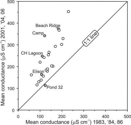
Not surprisingly, a suite of limnological and biological variables also changed as the ponds desiccated. For simplicity, we report only specific conductance values, a limnological variable that measures the concentration of ions in the water and reflects the effect of increased E/P on Arctic ponds (2). Fig. 3 shows the average conductance values for all 24 lower peninsula ponds that we have been monitoring since 1983. In an attempt to standardize these values for comparison, we report the specific conductance values measured on July 14 for each sampling year, or as close to that date as possible. We averaged these specific conductance values for each pond from the 1983, 1984, and 1986 field seasons (i.e., our three earliest field seasons), and compared the means to average specific conductance values recorded at the same ponds in 2001, 2004, and 2006. The average conductance values in the 1980s were clearly lower (at times by as much as ≈50%) than during this current decade (Fig. 3). Only one site (Pond 32) did not show this increase in July conductance over the intervening 24 years. This pond is the lowest elevation site on the peninsula, at the head of Herschel Bay, and receives snowmelt via several streams from the two high plateaus. Hence, as expected, this pond has not increased in July conductance.
Fig. 3.
Comparison of specific conductance values (as a proxy for evaporation/ precipitation; E/P) for July 14 (or as close to that date as possible) from the 24 lower peninsula ponds on Cape Herschel, measured in the three earliest field seasons (1983, 1984, and 1986), compared with measurements for the last three field seasons (2001, 2004, and 2006). Each point represents one of the Cape Herschel study sites; filled circles represent sites mentioned in the text and only these sites are labeled. If a point falls on the 1:1 line, no change in average water conductance has occurred since the 1980s. If the site points are above the 1:1 line, specific conductance has increased since the 1980s. From this analysis, it is clear that all ponds have increased in conductance since the 1980s, except one site (Pond 32), which is the lowest elevation pond on the Cape and is still receiving snowmelt via several streams in July from the two plateaus. Larger and deeper sites, such as Elison Lake, show smaller changes, as expected.
Average specific conductance for the lower peninsula ponds steadily recorded higher values with each passing decade. For example, the average specific conductance values for the lower peninsula ponds, measured closest to the July 14 sampling date for all years in the 1980s (1983, 1984, 1986, 1987) was 154 μS/cm. It was 177 μS/cm in 1995 and 1998. Most recently, it was 235 μS/cm in 2001, 2004, and 2006. A more detailed, year-to-year assessment of our specific conductivity measurements shows that the two most recent sampling years (i.e., 2004 and 2006) were much higher than even the late-summer conductance values recorded in August 1987.
The recorded changes in water chemistry and water levels are clearly affecting the biota of the ponds, both indirectly (through water chemistry changes) and directly (by loss of water). This is perhaps most clearly seen in a photograph (Fig. 1D) that shows the last surviving aquatic invertebrates (a near monoculture of the fairy shrimp, Branchinecta paludosa) in Camp Pond on July 11, 2006 (Fig. 2D) the day before the pond completely desiccated. In addition, many other aspects of pond biology were affected. For example, following the desiccation of Camp Pond, we removed a sample of the uppermost sediments and examined the diatoms present. An interesting feature of the most recently deposited diatoms was the presence of a few teratological (i.e., deformed) frustules, an observation that was hitherto not recorded in our previous detailed diatom paleolimnological study of Camp Pond, which extended back to its formation over four millennia ago (4). Teratological diatom frustules have previously been linked to environmental stressors (7).
The focus of our long-term studies has been on the “permanent”, or so we thought, ponds on Cape Herschel. However, it is evident that the surrounding wetland ecosystems are also severely affected. For example, in the early 1980s, parts of the lower peninsula were characterized by relatively lush moss and grass wetlands, such as the area surrounding Willow Pond (Fig. 2I). In fact, some of these water pools (small ponds in the foreground of Fig. 2I) were sufficiently large in the 1980s that we assigned location numbers to some of these sites and sampled them for our water quality and biological surveys. Recently, however, these regions have been severely affected by warming and drying. Not only has the standing water evaporated, but the land is now so desiccated that the dry vegetation is easily ignited (Fig. 2J). The environmental repercussions of these ecosystem changes (i.e., shifting from a carbon sink accumulating organic matter, to a potential carbon source) give cause for concern.
Water loss has likely been related to a number of climatic factors. However, drainage via permafrost melting, as has been described for some Siberian surface waters (6), is not the main cause of water loss in areas such as Cape Herschel, as these ponds are excavated in basins that are underlain by granitic bedrock. Moreover, the increases in specific conductance (Fig. 3) are consistent with a rise in E/P. Based on meteorological data gathered by Environment Canada (8), the summer of 2006 was the warmest year on record for this part of the Canadian Arctic during our sampling period. The second warmest year on record in this region was 2005, a summer when our thermistor data recorded that ponds had similarly dried up in July. Meanwhile, precipitation data available for this region of the Arctic indicates generally wetter conditions (8). Therefore, the recent increase in E/P is likely a consequence of enhanced evaporation due to both warmer temperatures and extended ice-free conditions.
Aerial photographs of Cape Herschel were taken on July 5, 1959, and Aug. 5, 1973, both of which clearly show the ponds filled with water. Moreover, our detailed paleolimnological studies (4, 5) do not record any evidence of past desiccation events (e.g., aberrant diatom or invertebrate assemblages, physical changes in sediment structure and texture, etc.). In fact, observations of declining water levels dovetail with our paleolimnological data from these same ponds showing that, following several millennia of relative stability, unprecedented ecological changes began in the 19th century that were consistent with warming, indicating longer-ice free periods and associated limnological changes (4, 5). A subsequent metaanalysis of 55 paleolimnological profiles from the circumpolar Arctic recorded similar shifts in indicators showing that a number of ecological thresholds related to post-1850 warming were being crossed, such as changes in ice cover, availability of epiphytic substrates (e.g., aquatic moss proliferation), and/or thermal stratification (9), as well as other associated limnological changes, such as climate-related shifts in ionic and nutrient concentrations (10). Therefore, our long-term monitoring data, coupled with our current observations of desiccation, track the conclusion of environmental trends that began in the 19th century (4, 5), but have greatly accelerated with the most recent climatic warming. Of course, in particularly wet or cool summers, these ponds may refill and maintain water levels longer than those recorded in the 2005 and 2006 seasons.
A key “tipping point” has now been passed: Arctic ponds that were permanent water bodies for millennia (4, 5) are now ephemeral. The ecological ramifications of these changes are likely severe, and will cascade throughout the Arctic ecosystem (e.g., waterfowl habitat and breeding grounds, invertebrate population dynamics and food for insectivores, drinking water for animals, etc.). Furthermore, lower water levels will have many indirect environmental effects, such as further concentration of pollutants. Ironically, high Arctic ponds, which are such important bellwethers of environmental change, are now disappearing because of climatic warming.
Methods
The specific conductance measurements of the ponds' surface waters were taken by J.P.S. and M.S.V.D. for each sampling season since 1983, using the same calibrated Yellow Springs Instruments (Letchworth, Hertfordshire, U.K.) conductivity meter, following identical protocols for all of the sampling ponds (2). The thermistors we deployed in 2004 in some of the ponds (two per pond; one in the center of the pond, and the second on the nearby land to record air temperatures) were HOBO U12 data loggers.
Acknowledgments
We thank Dr. W. Blake, Jr., two journal reviewers, and members of our labs for comments on the manuscript. D. Phillips assisted in providing meteorological data. This research was supported by the Natural Sciences and Engineering Research Council and the Polar Continental Shelf Project and is contribution no. 68 to the Cape Herschel Project.
Abbreviation
- E/P
evaporation/precipitation.
Footnotes
The authors declare no conflict of interest.
This article is a PNAS Direct Submission. J.B. is a guest editor invited by the Editorial Board.
References
- 1.Arctic Climate Impact Assessment. Impacts of a Warming Arctic: Arctic Climate Impact Assessment. Cambridge, UK: Cambridge Univ Press; 2004. [Google Scholar]
- 2.Douglas MSV, Smol JP. Arch Hydrobiologie. 1994;131:401–434. [Google Scholar]
- 3.Douglas MSV, Smol JP, Blake W., Jr Bull Geol Surv Can. 2000;529:257–269. [Google Scholar]
- 4.Douglas MSV, Smol JP, Blake W., Jr Science. 1994;266:416–419. doi: 10.1126/science.266.5184.416. [DOI] [PubMed] [Google Scholar]
- 5.Quinlan R, Douglas MSV, Smol JP. Global Change Biology. 2005;11:1381–1386. [Google Scholar]
- 6.Smith LC, Sheng Y, MacDonald GM, Hinzman LD. Science. 2005;308:1429. doi: 10.1126/science.1108142. [DOI] [PubMed] [Google Scholar]
- 7.Smol JP. Pollution of Lakes and Rivers: A Paleoenvironmental Perspective. London: Arnold; 2002. [Google Scholar]
- 8.Meteorological Service of Canada. Climate Trends and Variabilities Bulletin. Ottawa: Environment Canada; 2007. [Google Scholar]
- 9.Smol JP, Wolfe AP, Birks HJB, Douglas MSV, Jones VJ, Korhola A, Pienitz R, Rühland K, Sorvari S, Antoniades D, et al. Proc Nat Acad Sci USA. 2005;102:4397–4402. doi: 10.1073/pnas.0500245102. [DOI] [PMC free article] [PubMed] [Google Scholar]
- 10.Douglas MSV, Smol JP. In: The Diatoms: Applications for the Environmental and Earth Sciences. Stoermer EF, Smol JP, editors. Cambridge, UK: Cambridge Univ Press; 1999. pp. 227–244. [Google Scholar]


