Abstract
New 14C dates from archaeological sites in Oaxaca, Mexico, support R. C. Kelly's observation that intervillage raiding may begin as soon as a region has segmentary societies. The oldest defensive palisade dates to 3260–3160 B.P. in conventional radiocarbon years, only a few centuries after village life was established. Over the next millennium raiding evolved into war, with residences and temples burned, captives killed, and populations moving to defensible hills. 14C dates are now available for the first use of hieroglyphic writing to record a captive's name, military victories leading to the consolidation of the Zapotec state, the first skull rack, and the building of a fortress in conquered territory.
War is well documented in ancient states and empires. Tracing its origins back to earlier societies has proven more challenging. Data from Stone Age Nubia (1) show that even hunting–gathering groups occasionally massacred their neighbors. Studies of more recent agricultural tribes and chiefdoms by Carneiro (2), Keeley (3), and Redmond (4) reveal high frequencies of raiding, high per capita death rates, torture, and headhunting. On the other hand, groups like the Mbuti and !Kung appear warless to many anthropologists. Why do some societies display armed conflict and others not?
A recent cross-cultural study by Kelly (5), Warless Societies and the Origin of War, takes on this question and in so doing, provides a framework for prehistorians. Kelly found the highest incidence of warlessness among unsegmented societies: hunter–gatherers with no level of organization beyond the local group, relatively impermanent extended families, and little tendency to form segments like lineages and clans. While such societies may have individual homicide (and capital punishment for it), group violence is rare.
The case was different among societies divided into equivalent segments, such as patrilineal, matrilineal, or ancestor-based cognatic descent groups, which combine into progressively more inclusive units. Such segmentary societies (which are usually agricultural, but can include foragers) display a principle Kelly calls social substitutability. The killing of any member of another segment is considered a group offense, and can be avenged by killing any member of the offender's segment. Raiding thus begins as group vs. group social action, and can escalate into war as societies grow in scale and complexity.
A significant observation by Kelly is that raiding often begins in the richest environments, where societies “can afford to have enemies for neighbors”; conditions of scarcity encourage mutually beneficial cooperation. The higher the population, the greater the storage facilities, and the more reliable the surplus, the greater the likelihood for segmentary organization and war.
The Evidence from Oaxaca
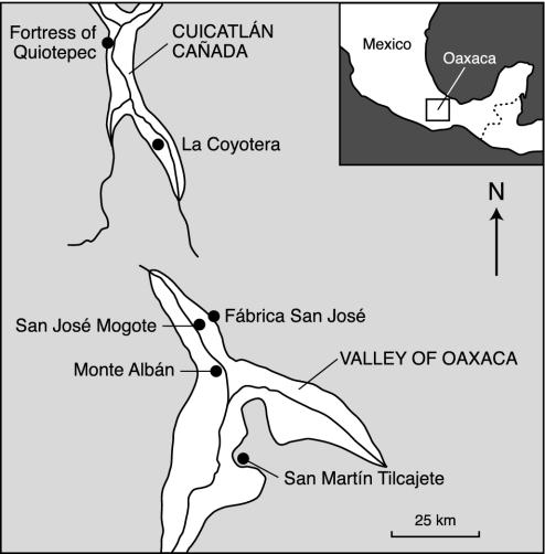
Kelly's model can be tested in the Valley of Oaxaca, 400 km south of Mexico City (Fig. 1), owing to collaborative research by the Universities of Michigan (6), Purdue (7), Georgia, and Wisconsin (8), and the American Museum of Natural History (9). Armed conflict in Oaxaca seems to have begun as raiding, involving killing, burning, and captive taking but no permanent acquisition of territory. By the time sixteenth-century Spanish eyewitnesses arrived, the Zapotec-speaking inhabitants of the valley had armies with noble officers and commoner footsoldiers, waging wars that produced tribute from conquered territories (10, 11).
Fig. 1.
The Oaxaca region, Mexico, showing places mentioned.
We present 14C dates for the origin of Zapotec war three ways. “B.P.” refers to conventional radiocarbon years before the present. “B.C.” refers to the 2 σ range of each date when converted to calendar years B.C. (before Christ) by dendrocalibration. Lowercase “b.c.” refers to conventional radiocarbon years B.C.E. (before the Christian era), derived by the 50-year tradition of subtracting 1950 from the B.P. date. (It is necessary to do this because Mexico's pre-Hispanic chronology is still heavily based on such b.c. dates.)
Warless Societies: The Archaic Period, 10,000–4,000 B.P.
The Archaic period in Oaxaca was a time of hunting, gathering, and early attempts at agriculture (6). Human populations were small and nomadic, coalescing into groups of 25–30 at times of resource abundance and dispersing into family bands of 4–6 persons in other seasons (12). Even the domestication of maize before 5420 ± 60 B.P. (13) did not lead immediately to village life. As recently as 4000 B.P. (14) there is evidence only for temporary camps. The Archaic has produced no evidence for segmentary societies or group conflict.
The Establishment of Village Life
Sometime before 3600 B.P. village life was established at San José Mogote, overlooking a river in the northern part of the valley (6). The site occupied a piedmont spur in one of the richest environments in the valley, surrounded on three sides by high-water-table alluvium.
By the start of the Tierras Largas phase (3500–3100 B.P.), there were at least 19 villages in the valley (8). San José Mogote, the largest, had a population numbering in the hundreds. There were nuclear family houses of wattle-and-daub; subterranean storage pits, collectively holding up to 1,000 kg of maize per household; and ritual “men's houses” like those known ethnographically from segmentary societies (6). House 19, one of the earliest of this phase, had been burned, possibly during a raid by a rival village. Charcoal from one of its posts yielded a date of 3490 ± 80 B.P., or 1540 b.c. (Beta Analytical laboratory no. β173807).
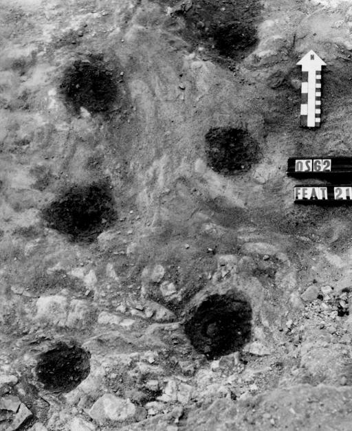
It appears that during this time, the western periphery of San José Mogote was defended by a palisade. This palisade took the form of a double line of posts, spaced in such a way that posts of the second line faced the gaps between posts in the first line (Fig. 2). Palisades of this type were used by the eighteenth-century Maori (15).
Fig. 2.
Six burned postholes in an early palisade at San José Mogote (3260–3160 B.P.). Scale (right side of arrow) is marked in centimeters.
We do not know whether the palisade at San José Mogote protected the entire village or only one part. Its postholes could be mapped only where bedrock was firm and level; where bedrock sloped down, the holes were lost. Posts could be traced intermittently for 30–40 m, until they disappeared under modern cattle pens.
Several posts in Feature 21, the best-preserved section of palisade, had been burned. 14C dates on charcoal from three posts gave dates of 3260 ± 60 B.P., or 1310 b.c. (β177623); 3160 ± 130 B.P., or 1210 b.c. (β175895); and 3250 ± 80 B.P., or 1300 b.c. (β175896). Feature 21 is the oldest directly dated defensive work in ancient Mexico. It meets Kelly's expectations by occurring at a village (i) in a relatively rich environment, (ii) with abundant storage facilities for agricultural surplus, and (iii) with a population high enough to be divided into social segments.
During the subsequent San José phase (3100–2800 B.P.) San José Mogote's population grew to more than 1,000 persons, evidently making it secure enough to expand beyond the palisade. We have no clear evidence of raiding during this period, but evidence for social segments is strong. Different residential wards at the village maintained separate public buildings, and there is iconographic evidence for ancestor-based descent groups (6). Sumptuary goods in houses and graves also indicate that a hereditary elite had emerged.
The Escalation of Raiding: 2800–2450 B.P.
During the Guadalupe phase (2800–2650 B.P.) San José Mogote remained the largest community in the valley, but other chiefly centers were arising only a day's journey away. None of these new centers were yet in a position to challenge San José Mogote; however, some of the latter's satellite villages were vulnerable. One of those satellites was Fábrica San José, a salt-producing village 5 km to the east.
At least three Guadalupe phase houses at Fábrica San José were burned, leaving masses of burned clay from their wattle- and-daub walls. House LG-1 yielded 828 pieces of daub totaling 41 kg; House LG-3 had a charcoal stripe 90 cm long from a burned roof beam; and the destruction of House LG-5 resulted in “enormous quantities of burned daub” (16). All three houses may have been burned during raids.
Intervillage raiding, presumably increased by competition among rival chiefs for land, water, and manpower, reached its peak during the Rosario phase (2650–2450 B.P.). There were now 75–85 communities in the valley, and chunks of burned daub appear on the surface of Rosario phase sites with 7 times the frequency observed at typical Valley of Oaxaca sites (8). Each of the three main parts of the valley was controlled by a chiefly center, with an intervening 80-km2 buffer zone left virtually unoccupied. San José Mogote in the northern valley was still the largest center, at 60–65 hectares (ha); San Martín Tilcajete in the southern valley, at 25 ha, was probably its main rival (17, 18).
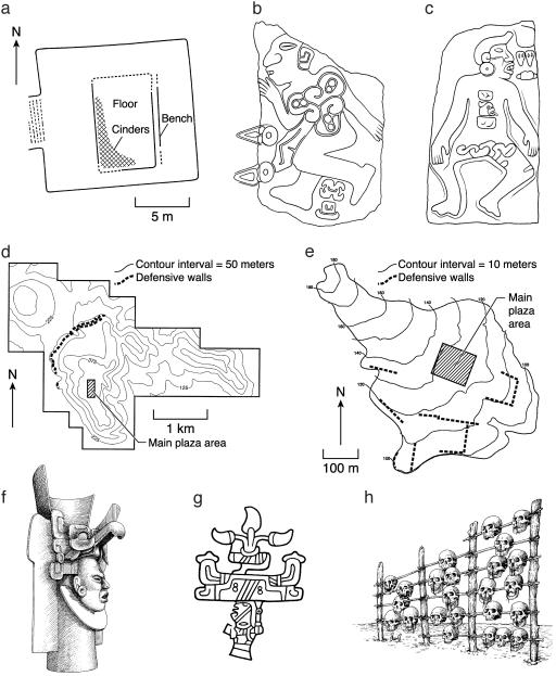
Midway through the Rosario phase, San José Mogote was attacked and its main temple, Structure 28, burned. So intense was the fire that the clay of the temple walls was reduced to vitrified cinders (Fig. 3a). Charcoal from a fallen roof beam among those cinders has been dated to 2550 ± 60 B.P., or 600 b.c. (β177624).
Fig. 3.
Landmarks in the development of Zapotec warfare. (a) Structure 28 of San José Mogote, a temple burned at 2550 B.P. (b) Monument 3 of San José Mogote, a carved stone showing a sacrificed captive with his hieroglyphic name between his feet (see Fig. 4). (c) Carved stone from early Monte Albán, showing a slain (and sexually mutilated) captive with his hieroglyphic name on his chest. (d) Monte Albán, showing walls defending its most vulnerable NW slopes. (e) Tilcajete, showing walls defending its most vulnerable southern slopes. (f) Effigy vessel showing a warrior in a raptorial bird helmet. (g) Hieroglyph for “place of the chile peppers”; the inverted head indicates it was “conquered” by Monte Albán. (h) Skull rack erected at 1960 B.P. Redrawn from refs. 6, 9, and 23.
Chiefly Warfare and the Origin of Writing: 2650–2450 B.P.
Structure 28 was never rebuilt. Instead a new Rosario temple, Structure 37, was built only a few meters to the north. Charcoal from a burned post in one wall of Structure 37 has recently been dated to 2540 ± 90 B.P., or 590 b.c. (β177626). This date suggests no great lapse of time between the burning of the old temple and the building of the new one.
Both Structures 28 and 37 rested on stone masonry platforms separated by a narrow corridor. At some point after the construction of the new temple, a carved stone was set in place as a threshold for this corridor. The carving, known as Monument 3, depicts the naked corpse of a captive whose heart has been removed (Fig. 3b). Between his feet is the Zapotec hieroglyph for his name. This stone would appear to commemorate the sacrifice of a chiefly rival taken in combat. The fact that his name is given may provide another analogy with Maori warfare. As Buck says, “No matter how great the casualty list after an engagement, if there were no chiefs killed, there was nothing much to talk about. If there was no chiefly name to connect the engagement with a tribal genealogy, the battle was without a name” (19).
Because Monument 3 is our first record of captive taking and hieroglyphic writing, its date is of some importance. We have previously indicated that its stratigraphic context and associated ceramics date it to the Rosario phase (6). However, the fact that a stone monument cannot be directly 14C dated has encouraged a few attempts to date it to later periods (e.g., ref. 20). Such attempts are contradicted by the stratigraphy, and, fortunately, dates from the overlying level now provide us with a terminus ante quem for this carved stone.
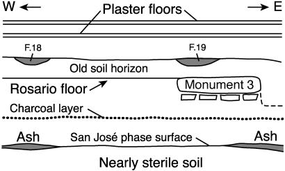
The dates come from two well made stone-lined hearths, Features 18 and 19, which were dug into the humic layer of a soil horizon that formed above Monument 3 after it (and the buildings flanking it) fell into disuse (Fig. 4). Charcoal from Feature 18 dated to 2510 ± 40 B.P., or 560 b.c. (β173808). Charcoal from Feature 19 dated to 2580 ± 40 B.P., or 630 b.c. (β175898). Because Monument 3 was sealed stratigraphically below the layer to which these hearths belong, it can date no later than 2580–2510 B.P. We conclude that (i) by that time it had become important to record the sacrifice of elite captives in stone, and (ii) one of the earliest uses of writing was to give the captive's name (21).
Fig. 4.
Monument 3 of San José Mogote lay stratigraphically below 1.72 m of later strata, only the lowest of which are shown here. Two hearths in the old soil horizon above the monument, F. 18 and F. 19, date to 2510 B.P. and 2580 B.P., respectively (Table 1). The charcoal layer below Monument 3 dates to 2670 ± 40 B.P. (β179879). The 14C date of the San José phase surface is 2960 ± 40 B.P. (β176907).
Military Consolidation of the Valley of Oaxaca: 2450–2000 B.P.
Some time before 2450 B.P., presumably seeking a more defensible location, the occupants of San José Mogote and its satellite communities moved to the summit of a 400-m mountain. This mountain, known as Monte Albán, lay in the former buffer zone between rival polities (7). The new arrivals, at least 2,000 strong, began building 3 km of defensive walls along the more easily climbed western slopes of the mountain (Fig. 3d). They also began work on a building with more than 300 carved stones depicting slain captives (Fig. 3c). For the next 400 years they would fight relentlessly to subjugate their political rivals, and raiding would give way to full-scale war.
During the period known as Early Monte Albán I (2450–2250 B.P.) the population of the Valley of Oaxaca grew to an estimated 8,000–10,000 persons, distributed through 261 communities (8). Nearly a third of the valley's population lived on the defended mountaintop at Monte Albán. They had the support of the entire northern and central valley, the region from which their founding populations had come. A day's journey to the south, however, lay Tilcajete, an unyielding rival. One of the most interesting stories to emerge from recent research is Monte Albán's use of military force to subjugate Tilcajete. Details and 14C dates have been provided by Spencer and Redmond (9, 17, 18).
Tilcajete's response to the founding of Monte Albán was to double its own size, from 25 ha to 52.8 ha; future research may show that it drew in manpower from satellite villages for defense. Tilcajete built a civic-ceremonial plaza with an astronomical orientation different from Monte Albán's. Its defiance deprived it of luxury goods that Monte Albán supplied to its allies. Then, toward the end of Early Monte Albán I, Tilcajete was attacked by Monte Albán and its plaza was burned (18). Charcoal from this conflagration (9) has been dated to 2280 ± 40 B.P., or 330 b.c. (β147541).
Tilcajete refused to capitulate. During the period known as Late Monte Albán I (2250–2000 B.P.), it grew to 71.5 ha and built a new plaza on a more easily defended ridge. The new civic-ceremonial center retained the astronomical orientation of its predecessor, and added defensive walls on its most easily climbed southern flanks (Fig. 3e).
Monte Albán, however, was prepared for a long campaign; it concentrated thousands of farmers, artisans, and warriors in 155 satellite villages within 15 km of its plaza (8). Eventually it attacked Tilcajete again, burning both the ruler's palatial residence and a nearby temple (9). Charcoal from the burned residence (currently our oldest dated Zapotec palace) came out 1970 ± 60 B.P., or 20 b.c. (β143355). Charcoal from the burned temple dated to 1980 ± 70 B.P., or 30 b.c. (β143353).
Tilcajete did not survive this second attack. It was abandoned, and on a mountaintop nearby, its conquerors commissioned an administrative center subordinate to Monte Albán (22). At this point Monte Albán controlled the entire 2,150-km2 Valley of Oaxaca and had become the capital of a Zapotec state (18).
Military Expansion Outside the Valley of Oaxaca: 2000–1700 B.P.
Over the next 200 years, the Zapotec state expanded 150 km beyond the limits of the Valley of Oaxaca. One building in the civic-ceremonial plaza at Monte Albán displayed hieroglyphic names for more than 40 places claimed as provinces (Fig. 3g). Only a handful of these places have been identified, but that identification has provided evidence for Zapotec expansion. One of the best-studied places is the Cuicatlán Cañada, an arid tropical river canyon 80 km north of Monte Albán. Both the details of conquest and the 14C dates are provided by Spencer and Redmond (11, 17, 23).
The Zapotec military encountered little resistance in Cuicatlán, burning villages on the river alluvium and moving the population to the piedmont to make way for new irrigation canals. At one village, La Coyotera, the conquerors erected a feature the Zapotec called yàgabetoo, a wooden rack displaying the skulls of 61 of the vanquished (Fig. 3h). A carbonized postmold from this rack (17) dated to 1960 ± 100 B.P., or 10 b.c. (β143344). The Zapotec then built a major fortress near the region's northern gateway. Charcoal from construction fill in this fortress (17) provides a date of 1910 ± 70 B.P., or A.D. 40 (β147535).
By this period, known as Monte Albán II, Zapotec armies were so professionalized that celebrated warriors were given helmets depicting pumas, coyotes, or raptorial birds (Fig. 3f). It is likely that by 2000 B.P., only 1,200 years since the first palisaded village, the Zapotec were already waging war on the scale witnessed by the 16th-century Spaniards (Table 1).
Table 1. 14C dates for the origin and development of war in Oaxaca.
| Prehistoric event | Conventional 14C yr B.P. | B.P. date minus 1950 | Dendrocalibrated 2σ range | Lab no. |
|---|---|---|---|---|
| Oldest burned house | ||||
| House 19, San José Mogote | 3490 ± 80 | 1540 b.c. | 2020-1620 B.C. | β173807 |
| Oldest palisade | ||||
| Feature 21, San José Mogote | 3260 ± 60 | 1310 b.c. | 1680-1410 B.C. | β177623 |
| 3160 ± 130 | 1210 b.c. | 1720-1060 B.C. | β175895 | |
| 3250 ± 80 | 1300 b.c. | 1700-1390 B.C. | β175896 | |
| Oldest burned temple | ||||
| Structure 28, San José Mogote | 2550 ± 60 | 600 b.c. | 820-500 B.C. | β177624 |
| Burned temple replaced | ||||
| Structure 37, San José Mogote | 2540 ± 90 | 590 b.c. | 840-400 B.C. | β177626 |
| Oldest monument with named elite captive (terminus ante quem) | ||||
| Feature 18, San José Mogote | 2510 ± 40 | 560 b.c. | 790-500 B.C. | β173808 |
| Feature 19, San José Mogote | 2580 ± 40 | 630 b.c. | 820-760 B.C. | β175898 |
| Monte Albán burns Tilcajete: 1 | ||||
| Early plaza burned | 2280 ± 40 | 330 b.c. | 400-350 B.C. | β147541 |
| Monte Albán burns Tilcajete: 2 | ||||
| Structure 7 (palace) burned | 1970 ± 60 | 20 b.c. | 100 B.C.-A.D. 140 | β143355 |
| Structure 16 (temple) burned | 1980 ± 70 | 30 b.c. | 165 B.C.-A.D. 155 | β143353 |
| Monte Albán conquers Cuicatlán | ||||
| Skull rack, La Coyotera | 1960 ± 100 | 10 b.c. | 190 B.C.-A.D. 255 | β143344 |
| Fortress, Quiotepec | 1910 ± 70 | A.D. 40 | 50 B.C.-A.D. 250 | β147535 |
Acknowledgments
We thank the Office of the Vice President for Research, University of Michigan, for providing us with funds to run an extensive series of 14C dates from Oaxaca. All new dates were run by Beta Analytic of Miami, FL.
Abbreviations: B.C., calendar years before Christ; b.c., conventional radiocarbon years before the Christian era; ha, hectare.
See commentary on page 11185.
References
- 1.Wendorf, F. (1968) Prehistory of Nubia (Southern Methodist Univ. Press, Dallas), Vol. 2, pp. 954–995. [Google Scholar]
- 2.Carneiro, R. L. (1991) Anthropol. Pap. Mus. Anthropol. Univ. Mich. 85, 167–190. [Google Scholar]
- 3.Keeley, L. H. (1996) War Before Civilization (Oxford Univ. Press, New York).
- 4.Redmond, E. M. (1994) Tribal and Chiefly Warfare in South America (Museum of Anthropology, Univ. of Michigan, Ann Arbor).
- 5.Kelly, R. C. (2000) Warless Societies and the Origin of War (Univ. of Michigan Press, Ann Arbor).
- 6.Marcus, J. & Flannery, K. V. (1996) Zapotec Civilization (Thames and Hudson, New York).
- 7.Blanton, R. E. (1978) Monte Albán: Settlement Patterns at the Ancient Zapotec Capital (Academic, New York).
- 8.Kowalewski, S. A., Feinman, G. M., Finsten, L., Blanton, R. E. & Nicholas, L. M. (1989) Monte Albán's Hinterland, Part II (Museum of Anthropology, Univ. of Michigan, Ann Arbor).
- 9.Spencer, C. S. & Redmond, E. M. (2003) Social Evol. Hist. 2, 25–70. [Google Scholar]
- 10.de Burgoa, F. (1934) Publ. del Archivo Gen. Nación (Talleres Gráficos de la Nación, México D.F., México), Vols. 24–26.
- 11.Redmond, E. M. (1983) A Fuego y Sangre: Early Zapotec Imperialism in the Cuicatlán Cañada (Museum of Anthropology, Univ. of Michigan, Ann Arbor).
- 12.Flannery, K. V. (1986) Guilá Naquitz: Archaic Foraging and Early Agriculture in Oaxaca, Mexico (Academic, Orlando, FL).
- 13.Piperno, D. R. & Flannery, K. V. (2001) Proc. Natl. Acad. Sci. USA 98, 2101–2103. [DOI] [PMC free article] [PubMed] [Google Scholar]
- 14.Lorenzo, J. L. (1958) Inst. Nac. Antropol. Hist. Dir. Prehist. No. 6.
- 15.Fox, A. M. (1976) Prehistoric Maori Fortifications in the North Island of New Zealand (Longman Paul, Auckland, NZ), Fig. 106.
- 16.Drennan, R. D. (1976) Fábrica San José and Middle Formative Society in the Valley of Oaxaca (Museum of Anthropology, Univ. of Michigan, Ann Arbor), p. 99.
- 17.Spencer, C. S. & Redmond, E. M. (2001) Latin Am. Antiq. 12, 182–202. [Google Scholar]
- 18.Spencer, C. S. & Redmond, E. M. (2001) J. Anthropol. Archaeol. 20, 195–229. [Google Scholar]
- 19.Buck, P. H. (1949) The Coming of the Maori (Whitcombe and Tombs, Wellington, NZ), p. 400.
- 20.Pohl, M. E. D., Pope, K. O. & von Nagy, C. (2002) Science 298, 1984–1987. [DOI] [PubMed] [Google Scholar]
- 21.Marcus, J. (1992) Mesoamerican Writing Systems: Propaganda, Myth, and History in Four Ancient Civilizations (Princeton Univ. Press, Princeton, NJ), p. 441.
- 22.Elson, C. (2003) Ph.D. dissertation (Univ. of Michigan, Ann Arbor).
- 23.Spencer, C. S. (1982) The Cuicatlán Cañada and Monte Albán: A Study of Primary State Formation (Academic, New York).


