Abstract
The movements of Atlantic bluefin tuna (Thunnus thynnus thynnus) have captured the interest of scientists and fishers since the time of Aristotle. This tuna is unique among bony fish for maintaining elevated body temperatures (21°C above ambient) and attaining large size (up to 750 kg). We describe here the use of a pop-off satellite tag, for investigating the Atlantic-wide movements and potential stock overlap of western and eastern Atlantic bluefin tuna. The tag also archives data on water temperatures. The objectives of this study were to evaluate the effectiveness of the technology, study the movements of Atlantic bluefin tuna, examine their thermal niche, and assess survivorship of tagged fish. The pop-off satellite technology provides data independent of commercial fisheries that, when deployed in sufficient quantity, should permit a critical test of the stock structure hypotheses for Atlantic bluefin tuna.
Atlantic bluefin tuna are endothermic fish (1), seasonally distributed over the north Atlantic Ocean and Mediterranean Sea, where they are exploited intensively by commercial and recreational fisheries. Despite international management, exploitation has reached a peak in the past decade (2) and the sustainability of the fishery is in question. Bluefin tuna in the Atlantic and Mediterranean are managed as separate eastern and western stocks. Considerable debate centers on the appropriateness of this subdivision given the evidence for trans-oceanic mixing (3). To understand the life history of bluefin tuna and develop competent management strategies, temporal and spatial movement patterns must be identified (4). Data on bluefin tuna dispersal patterns have been difficult to obtain because of the limited resolution of analytical tools available for studying pelagic fish. To date, tag and recapture programs using conventional tags (fisheries-dependent indicators of movement) have been the method of choice for describing the distribution of Atlantic bluefin tuna, as in most tuna fisheries (5). Conventional tag and release data indicate that trans-Atlantic movements of all size classes of Atlantic bluefin tuna occur (3, 6–8). Recently, microprocessor-based, data storage tags (archival tags) have been developed for monitoring the geoposition (based on ambient light levels), thermal physiology, and diving behavior of large pelagic vertebrates (9–13). Although the data intensity of archival tags is high (2 megabytes), their major limitation is the need to recapture the animal to access the data. This requires deployment of large numbers of tags in species with high exploitation rates. In addition, the multinational nature of most oceanic fisheries complicates the coordination of archival tag recoveries. Archival tags have been deployed recently on Atlantic bluefin tuna (9), but significant numbers of returns take years to retrieve. Satellite tags (conventionally towed or attached) have been employed to study the large-scale movements and physiology of marine mammals, birds, and sea turtles (14–18). These tags have been deployed successfully on basking sharks, (19) but are only applicable for the largest pelagic fishes that frequent the surface. The new pop-off methodology will broaden the scope of satellite tag utility to most large pelagic organisms.
The single-point, pop-off satellite tag is designed to define movements of pelagic fish for which towed satellite tags are ineffective (Fig. 1). The satellite tag is attached externally to a fish, releases at a preprogrammed time because of a corrosive linkage, floats to the surface, and then transmits continuously to ARGOS satellites. The tag provides a fisheries-independent measure of the straight-line distance traveled from the point of tagging. The lithium battery, microprocessor, and 0.150-W satellite transmitter were packaged in a carbon fiber tube. A streamlined float constructed of syntactic foam, a microballoon resin composite, was secured to the trailing end of the tube. The torpedo-shaped tag weighed between 65 and 71 grams in air and had a density of 0.95. The shape, pressure resilience, and the size of the floats were varied slightly to compare tag performance with different flotation regimes. The center of buoyancy and mass are such that the tag floats with the antenna extending upward when on the surface. While attached, the antenna extends parallel to the fish and the syntactic foam float provides sufficient lift to keep the tag off the body at low speeds. Each first-generation tag logged 61 water temperature measurements. In the short-term tags, average daily temperatures are recorded, followed by temperature data acquired hourly. In long-term tags, the first 60 measurements are daily average temperatures, each compiled from measurements taken over the previous 24 hr. The 61st data point is the average temperature of the day before pop-off.
Figure 1.

Pop-off satellite tag. The monofilament leader (not shown) is attached through the plastic eye loop on the nose cone and is held in place by #316 stainless-steel wire, which corrodes at a programmed date, releasing the tag from the fish. (Bar = 2 cm.) The tag was manufactured with Telemetry 2000, Inc.
A unique opportunity to conduct a large-scale study of medium (61–141 kg) and giant (>141 kg) bluefin tuna emerged in 1996 and 1997 off Cape Hatteras, NC, where large bluefin tuna have been abundant recently in winter months, within 8 nautical miles of the coast. These bluefin tuna take menhaden bait aggressively, making it easy to catch and release large fish in short durations. In February and March of 1997, a total of 37 short- (3- to 14-day) and long-term (60- to 90-day), single-point, pop-off satellite tags were deployed on bluefin tuna ranging in size from 96 to 181 kg. The pop-off tags were secured to the bluefin during a combined experimental design in which the major objective was to surgically implant 160 archival tags in bluefin up to 234 kg in size. Six bluefin were double-tagged with pop-off and archival tags.
A similar handling procedure was used to deploy both satellite and archival tags. All fish were caught on rod and reel with heavy tackle (60-kg gear) to minimize fight times. Most of the bluefin tuna used in the pop-off tag experiments (36 of 37) were caught on circle hooks, which tend to catch the fish in the corner of the jaw and are removed easily. The fish were pulled through an open door at the waterline of a small fishing vessel onto a wet, vinyl-covered pad. Once on deck, a saltwater hose was placed in the mouth to irrigate the gills and the eyes were covered with a sea-water-soaked blindfold. Curved body length was measured, allowing calculation of the fish mass. The pop-off satellite tags were attached to the tuna by using a dart machined of stainless steel, titanium, or molded, medical grade nylon. The dart was inserted 10 cm deep, at the base of the second dorsal fin, where it anchored through bony projections and connective tissue radiating ventrally from the fin. Each tag was connected to its anchor by a 20- to 25-cm-long, 136-kg monofilament leader attached through the eye loop at the front end of the tag. The eye loop was fixed in place by a thin, stainless-steel wire that was exposed to sea water externally and connected internally to a battery. At the programmed time, the microprocessor activates the battery, which passes a low voltage across the wire promoting corrosion and release. The fish were on deck, on average, for 2 min. Experiments on captive tunas held in Pacific Grove, CA, indicate that because the tuna body narrows after the second dorsal fin, tags placed here had minimal contact with the body and did not disturb normal swimming patterns.
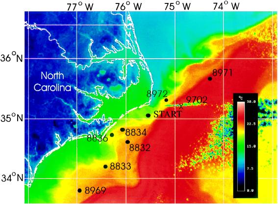
In the first experiment, nine tags were deployed for 3–14 days (Fig. 2). These tags varied in buoyancy, providing the opportunity to test the performance of variable float designs and weight distributions. The quality of the satellite transmission was used to evaluate and improve tag design. Tags with a large separation of the center of mass and center of buoyancy function the best. The deployment of the short-term tags provided a direct measure of survivorship, ensuring that the handling procedures and tagging event did not cause mortality. Survivorship for the short-term experiment was 100%; all tags released and communicated with the ARGOS satellites. Endpoint locations were determined from seven of nine tags. Two tags transmitted intermittently, and locations could not be determined reliably close to the pop-off date. Both tags had a high center of mass, reducing stability. Thermal data, however, was obtained from all tags. All pop-off, end point locations indicate that the bluefin were close to the initial release site (Fig. 2), suggesting the bluefin remain in this vicinity for at least 2 weeks.
Figure 2.
AVHRR image of Cape Hatteras with seven short-term, pop-off tag endpoints (solid circles). Shown are three-day tags (8832, 8969, 8971, 8972), 5-day tag (8833), 7-day tag (8834), and 14-day tag (8836). 9702 (X) is the endpoint of a short acoustic track of a fish released with pop-up satellite-tagged bluefin 8971 and 8972. Tags were deployed from February 26, 1997 to March 17, 1997. AVHRR image is a composite image from the week of March 17. Colors indicate sea surface temperatures. The positions of the Gulf Stream (red) and the Labrador current (blue) were consistent throughout the 3-week period of this experiment. All experiments began at start point.
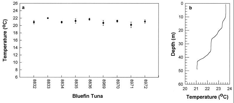
In the winter of 1997 at Cape Hatteras, NC, the western edge of the Gulf Stream was close to land and formed a discrete edge with the Labrador current to the north. Temperatures across this western boundary of the Gulf Stream can change by as much as 15°C in one nautical mile. All tags popped off in the Gulf Stream or along the western frontal zone, indicating the bluefin tuna prefer the warmer water mass to the cooler Labrador current or coastal waters in this location. The mean water temperatures experienced by the nine bluefin over the cumulative period of data collection from all tags (32 days) was 21.3 ± 1.1°C (Fig. 3a). The hourly temperature measurements varied little among individual fish and supported the conclusion the bluefin were over the continental shelf in warm Gulf Stream waters. Simultaneous measurements of the thermal depth profile (Fig. 3b) indicate the water column over the continental shelf in the area of the experiments is shallow <80 m depth (which constrains movements of the fish) and warm. Surface temperatures ranged from 22° to 24°C and bottom temperatures ranged from 17.5° to 21°C. The accuracy of the pop-off temperature data can be compared with thermal data retrieved from two bluefin tuna, archivally tagged during the same experiment, as well as acoustic-tagged fish (9). The archival tags record temperature in 2-min intervals. The acoustic tags transmit data at approximately 1-sec intervals. Both confirm that bluefin in the vicinity of Cape Hatteras experienced relatively constant, warm temperatures of the same values as reported by the pop-off tags (data not shown) and that fish are moving between the surface and the shallow bottom.
Figure 3.
(a) The mean (solid circles) of the average daily water temperatures (±SE) from nine short-term (3- to 14-day) pop-off tags. (b) Temperature with depth profiles (1 of 22 profiles shown) determined with a Seabird CTD probe revealed the warm water in the shallow continental shelf region off of Cape Hatteras. This profile was taken near the T in the word START in Fig. 2.
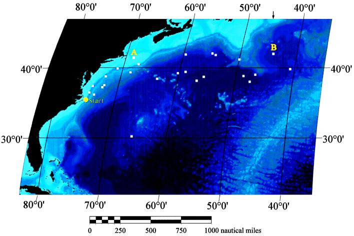
In the second experiment, 28 long-term tags were deployed for 60–90 days. The objectives were (i) to test long-term survivorship from handling procedures, (ii) to examine the movements and dispersion of the bluefin tuna in the western North Atlantic, (iii) to evaluate whether the tags would remain secured to the fish and operational over longer deployments, and (iv) to examine the water temperatures experienced by bluefin. The endpoint locations for the long-term deployments are shown in Fig. 4. The longitude of pop-off points ranged from 74.69°W to 40.76°W and latitudes ranged from 30.2°N to 42.04°N. Fourteen bluefin (111–181 kg) moved offshore in an east, northeast direction, along the path of the Gulf Stream. Their tracks terminated north of the New England Sea Mounts, south of the Grand Banks, or west of the mid-Atlantic ridge. Ten bluefin (111–137 kg) moved directly north of the release site to familiar U.S. bluefin tuna fishing grounds, such as Oceanographer and Hudson canyons and Georges Bank. Only one fish was located south of the release point, close to Bermuda. One tag did not provide a reliable location, but did provide a portion of the thermal data set. The furthest distance covered in 90 days was 1,670 nautical miles (bluefin 8890, 119 kg) and in 60 days was 1,242 nautical miles (bluefin 1425, 112 kg). The speed of straight-line travel for these two bluefin ranged from 0.77 to 0.86 nautical miles h−1 and was consistent with speeds observed for bluefin tracked acoustically (1). Although 10 bluefin were close to or greater than the body size known to be mature in the western Atlantic, none was located on the spawning ground in late May (during the Gulf of Mexico spawning season) or in June or July (when the Mediterranean spawning season occurs) (8). Future efforts will be aimed at tagging bluefin on the breeding grounds.
Figure 4.
Distribution of 60- and 90-day pop-off endpoint positions for 25 of 28 bluefin tuna tagged in February and March off Cape Hatteras, NC (Start). Positions for two bluefin whose thermal records are shown in Fig. 5 are delineated as 9752 (A) and 9851 (B). Of the 28 fish tagged, 25 were larger than 183 cm (102 kg) and 13 were larger than 190 cm (121 kg). The shades of blue represent depth; the shallow waters are lightest in color. Arrows at 45° W indicate the stock boundary.
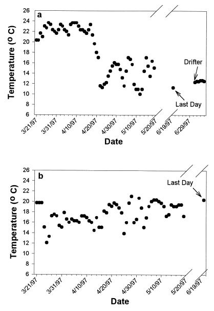
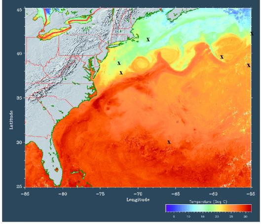
Fig. 5 shows the average daily temperatures recorded for the first 60 days for the two fish designated as A and B in Fig. 4. The New England fish (A) is a 111-kg bluefin tuna (9752) that moved to the north and, after 90 days, was on Georges Bank (denoted with the A). The second fish (B) was a 136-kg bluefin tuna (9851) that moved due east toward the mid-Atlantic Ridge. For the first 35 days, fish 9752 was in warm waters where temperature fluctuated little, suggesting that it remained in the Gulf Stream possibly near Cape Hatteras. The warm and narrow range of average water temperatures are consistent with the data from bluefin tagged with short-term, pop-off tags (Figs. 2 and 3) and acoustic- and archival-tagged fish in the vicinity of Cape Hatteras. This period of warm water temperatures was followed by a 9°C drop over 3 days, then a longer duration of cooler temperatures (9–17°C). This indicates that bluefin 9752 left the Hatteras area or Gulf Stream and spent more time in cooler waters. Although it is impossible to discern whether the cooler temperatures result from increased diving behavior or movement into a colder water mass, some insight can be gained by comparison with the archival data records (9). The archival tags depth data (B.A.B., D.H., T. Williams, C.F., and E.D.P., unpublished data) indicate that bluefin of the size classes tagged, spend more than 50% of the time in the surface waters, suggesting that the lower temperatures reflect movements out of the Gulf Stream on route to New England. This pattern illustrating a transition from warm to cold is representative of the bluefin whose tags released near the U.S. continental shelf. Surface water temperatures (SST) in late May and June off New England ranged from 8° to 12°C. Daily average water temperatures were as low as 6°C, indicating a remarkable tolerance for cold temperatures. Bluefin 9752’s 61st average temperature point for day 90 was 11°C (Fig. 5a). A comparison of point 61 and the corresponding SST acquired from Advanced Very-High Resolution Radiometer (AVHRR) imagery provided a high correlation confirming fish 9752’s position in the water mass (e.g., Fig. 6). At Georges Bank the SST was approximately 12°C at the end point location for tag 9752 (Fig. 6, X at Georges Bank). After tag 9752 released from the fish, the instantaneous SST acquired from the drifting tag was within a degree of the AVHRR sea surface temperature data. In Fig. 5b (fish 9851) the average daily temperatures are warmer throughout the first 60 days and there is no steep thermal change apparent. Bluefin that moved to the east have, on average, higher daily temperatures (13–20°C), and less variation than fish that travel directly north. AVHRR data, corresponding to the pop-off location, was difficult to obtain for several fish that traveled furthest to the east because of cloud cover but, when present, indicated the fish were in the Gulf Stream. AVHRR images were acquired for all fish west of 55° longitude (e.g., Fig. 6). When available (n = 20), a close correlation was obtained (±2°C) between temperature point 61 and the AVHRR-generated SST. This most likely reflects the bluefin’s high frequency of occurrence in the mixed layer (9). Several bluefin were located on the Gulf Stream edge or in warm core rings. Previous acoustic telemetry has indicated that frontal zones influence the movements of other species of tunas (albacore and yellowfin) in a manner similar to the bluefin’s association with the Gulf Stream edge (20, 21). Such oceanographic frontal zones are presumed to be regions of higher prey abundance.
Figure 5.
Daily average water temperatures for two bluefin tuna, denoted in Fig. 4 as A (9752) and B (9851), that went due north and east, respectively. Temperatures are recorded hourly and compiled as one 24-hr average (solid circles). The first 60 points represent the first 60 days, and the 61st data point is the average temperature from the last day before pop-off (day 90). The points after the final day are temperature measurements as the tag drifts on the surface after it releases from the fish. (a) Temperature data for bluefin 9752 (111 kg), which was double-tagged (both archival and pop-off tags deployed) and located on Georges Banks (A in Fig. 4) on June 21, 1997. (b) Thermal history for bluefin 9851, a 200-cm (136 kg) fish that moved the furthest north in the study and was in the Gulf Stream (not shown) when the tag released on June 19, 1997.
Figure 6.
Composite AVHRR imagery of the western north Atlantic on June 22, 1997. Seven endpoint positions of bluefin tuna that released on this date ±3 days are shown in relationship to surface water temperatures (X). Similar AVHRR imagery was used to correlate the 61st data point and sea surface temperatures for 13 additional fish. Fish 9752 of Figs. 4 and 5a is denoted with an X off of Massachusetts.
Thermal records of ambient temperatures were collected for 61 days from 26 bluefin for a total of 1,586 average temperature values, representing 38,064 individual measurements. The water temperature data indicate that western Atlantic bluefin experience daily average temperatures that range from 6° to 24°C in late winter and early spring. The Atlantic bluefin tuna has the widest thermal niche of all Scombridae. We associate this niche breadth with the bluefin’s large size and increased abilities to conserve metabolic heat (22). In addition to examining thermal preferences, the temperature data provide evidence for survivorship. If a mortality had occurred, the negatively buoyant bluefin would sink to the bottom and the temperature recorded would be cool and constant. Similarly, if the tag dislodges prematurely, the temperature readings would remain relatively constant as in the drifter portion of Fig. 5a. Only two pop-up satellite tags did not report back. It is uncertain whether this represents tag failure or mortality. One of these fish was double-tagged with both pop-off and archival tags. The remaining five double-tagged bluefin did surface. The second fish that failed to report was hooked deep in the gills with a J-shaped hook.
The 95% success rate (35 of 37 tags) for data recovery indicates the technology and concepts of pop-off satellite tagging are sound for medium and giant bluefin. This study demonstrates that tags can be secured to wild fish for up to 90 days. Although external tags have been attached to captive yellowfin tuna for more than 9 months, this is the first demonstration that deployments are possible in the field on large, active, pelagic fish that travel long distances. Data from other pelagic species (blue marlin) indicate tag retention for up to 9 months currently is possible by using the same techniques (B.A.B. and H.D., unpublished data). The programmed release mechanism is reliable; only 2 out of 37 tags failed to transmit. The temperature data from the tags can be routinely recovered in triplicate by using ARGOS satellites in 7–10 days. Importantly, the techniques developed for attachment and handling do not harm the fish. These preliminary efforts demonstrate the great potential for the continued use and development of pop-off satellite technology in pelagic fisheries research.
The International Commission for the Conservation of Atlantic Tunas presently manages the Atlantic bluefin tuna as separate east and west management units divided at the 45°W meridian. The two presumed stocks are thought to have independent spawning grounds. The eastern stock spawns in the Mediterranean Sea and along the equator off West Africa (23), and the western stock spawns in the Gulf of Mexico. Each stock is subject to different management restrictions with the most prominent difference being strict quotas and enforcement for the western fishery (2,394 metric tons) and a higher quota for the eastern fishery dominated by European nations (40,494 metric tons). There has been significant opposition to managing the Atlantic bluefin as two stocks both in the scientific community and among fishers. There is no biological evidence that indicates the large geographic separation of the spawning localities represents reproductive isolation (3). Mixing between western and eastern Atlantic bluefin has been evident in conventional tagging data for more than four decades, but the significance of these results to management has remained a matter of debate (3, 8). A recent review of the scientific basis for the management of Atlantic bluefin tunas recommended that the two-stock hypothesis be rigorously tested (3). The report emphasized the need to quantify the extent of bluefin tuna movement within and between the eastern and western Atlantic regions and the effects these movements might have on the choice of management strategies. Determination of both the extent of mixing of mature bluefin and the fidelity to a western or eastern spawning ground is critical for future bluefin tuna management. The pop-off satellite technology has the potential to improve the identification of discrete biological stocks, which is paramount to the implementation of effective management (4).
In this preliminary study, the pop-off tag results indicate the capacity for western Atlantic bluefin tuna to move into the western margin of the eastern Atlantic management zone within 90 days. Two bluefin crossed between management zones and four additional bluefin were within 5 degrees longitude of the stock boundary meridian. These results confirm that Atlantic bluefin from the “western stock” are subject to eastern fishing pressure, raising the question of how often such cross-boundary movements occur among mature individuals. It is now possible and imperative to make use of the new pop-off satellite tag technology to rapidly discern the magnitude and patterns of bluefin tuna movement. The new techniques, in contrast to conventional tagging, are fisheries-independent, offer a significantly higher return rate (current western bluefin tuna conventional tag return rates are 3%), and supply useful temperature data. The ability to specify when the tags release will increase the sophistication of the hypotheses that can be tested. Rapid development of the next generation of pop-off satellite tags, with increased archival capabilities, will dramatically improve data acquisition and provide the opportunity to test spawning area fidelity. The pop-up satellite archival tag will record daily position of the fish (or any large vertebrate) estimated from measurements of light intensity. Such tags will provide daily movement and distribution data of the animal in relationship to oceanographic temperature/depth profiles obtained directly from the tag. These data will be examined in relationship to remote data sets archived during the track, providing information on daily surface temperatures, currents, and productivity.
The recent technological advances in wildlife telemetry, as well as molecular genetics (24–28), provide fisheries researchers the tools needed to directly examine the short- and long-term movement patterns, stock structure, and behavior of large pelagic fish. It is now up to the international community to employ such techniques to provide fisheries managers the best information available for choosing management strategies. These new technologies have the power to resolve critical stock-structure issues surrounding bluefin tuna as well as other pelagic species. They also offer scientists and fishers the opportunity to work cooperatively to acquire the information that could ensure the recovery of the mature breeding stocks of Atlantic bluefin tuna in our lifetime.
Acknowledgments
We thank Dr. Paul Howey of Telemetry 2000, Inc. and Jurek Zawadzki of the Monterey Bay Aquarium for tag and float construction. Dr. Jim Huddlestun, Captains Bob Eakes, Peter Wright, Gary Stuve, and D. Aspenleiter along with their crews provided technical support and fishing expertise. T. Williams, A. Boustany, R. Novak, D. Fudge, D. Marcinek, J. Keen, C. Jones, G. Skomal, B. Chase, and M. Judge provided technical assistance. We thank Dan Dau for data analysis and the Johns Hopkins applied Physics Lab for AVHRR imagery. This research was supported by grants to B.A.B. from the National Marine Fisheries Service, National Science Foundation, National Undersea Research Center, Packard and MacArthur Foundations and the Cape Hatteras community’s Tag a Giant Conservation Series. This paper is dedicated to the memory of Francis G. Carey.
ABBREVIATIONS
- AVHRR
Advanced Very-High Resolution Radiometer
- SST
surface water temperature
References
- 1.Carey F G, Lawson J. Comp Biochem Physiol. 1973;44:375–392. doi: 10.1016/0300-9629(73)90490-8. [DOI] [PubMed] [Google Scholar]
- 2.International Commission for the Conservation of Atlantic Tunas. (1997) International Commission for Conservation of Atlantic Tunas, Collected Volume of Scientific Papers 46 (Madrid, Spain).
- 3.National Research Council. An Assessment of Atlantic Bluefin Tuna. Washington, DC: Natl. Acad. Press; 1994. , 148 pp. [Google Scholar]
- 4.Gulland J A. Fish Stock Assessment: A Manual of Basic Methods. FAO/Wiley Series on Food and Agriculture. New York: Wiley; 1983. [Google Scholar]
- 5.Lehodey P, Bertignac M, Hampton J, Lewis A, Picaut J. Nature (London) 1997;389:715–718. [Google Scholar]
- 6.Brunemeister S. International Commission for Conservation of Atlantic Tunas, Collective Volume of Scientific Papers. 1980;9:506–527. [Google Scholar]
- 7.Cort, J. J. & de la Serna, J. M. (1993) International Commission for Conservation of Atlantic Tunas Working Document, Standing Committee on Research and Statistics 93, 81 pp.
- 8.Mather, F. J., Mason, J. M. & Jones, A. C. (1995) National Oceanic and Atmospheric Administration Technical Memorandum, National Marine Fisheries Service–Southeast Fisheries Science Center 370, 165 pp.
- 9.Block B A, Dewar H, Williams T, Prince E, Farwell C, Fudge D. Mar Tech Soc J. 1998;32:37–46. [Google Scholar]
- 10.Delong R L, Stewart B S, Hill R D. Mar Mamm Sci. 1992;8:155–159. [Google Scholar]
- 11.Hill R D. In: Elephant Seals. LeBoeuf B J, editor. Berkeley: California Press; 1994. pp. 227–236. [Google Scholar]
- 12.Gunn J S, Polacheck T, Davis T L O, Sherlock M, Bethlehem A. Proceedings of the International Council for the Exploration of the Sea Mini Symposium on Fish Migration. 1994;21:1–23. [Google Scholar]
- 13.Metcalfe J D, Arnold G P. Nature (London) 1997;387:665–666. [Google Scholar]
- 14.Jouventin P, Weismerskirch H. Nature (London) 1990;343:746–748. [Google Scholar]
- 15.Kooyman G L, Kooyman T G, Horning M, Kooyman C A. Nature (London) 1996;383:397. [Google Scholar]
- 16.McConnell B J, Hambers C, Nicholas K S, Fedak M A. J Zool (London) 1992;226:271–282. [Google Scholar]
- 17.Papi F, Liew H C, Luschi P, Chan E H. Mar Biol. 1995;122:171–175. [Google Scholar]
- 18.Renaurd M L, Carpenter J A. Bull Mar Sci. 1994;55:1–15. [Google Scholar]
- 19.Preide I G. Fish Res. 1984;2:201–216. [Google Scholar]
- 20.Laurs R M, Yuen H S H, Johnson J H. Fish Bull USA. 1977;75:347–355. [Google Scholar]
- 21.Block B A, Keen J E, Castillo B, Brill R, Dewar H, Freund E, Marcinek D, Farwell C. Mar Biol. 1997;130:119–132. [Google Scholar]
- 22.Carey F G, Teal J M. Proc Natl Acad Sci USA. 1966;56:1464–1469. doi: 10.1073/pnas.56.5.1464. [DOI] [PMC free article] [PubMed] [Google Scholar]
- 23.Richards W J. International Commission for the Conservation of Atlantic Tunas, Coll Vol Sci Pap. 1976;5:267–278. [Google Scholar]
- 24.Finnerty J, Block B A. Mar Mol Biol Biotech. 1992;1:206–214. [PubMed] [Google Scholar]
- 25.Graves J E, McDowell J R. Can J Fish Aquat Sci. 1994;51:1762–1768. [Google Scholar]
- 26.Graves J E, McDowell J R. Mar Biol. 1995;122:193–203. [Google Scholar]
- 27.Rosel P E, Block B A. Mar Biol. 1996;125:11–22. [Google Scholar]
- 28.Ward R D, Elliot N G, Grewe P M, Smolenski A J. Mar Biol. 1994;118:531–539. [Google Scholar]


