

Abstract
Highly pathogenic avian influenza (HPAI) caused by H5N1 viruses has become a global scale problem which first emerged in southern China and from there spread to other countries in Southeast and East Asia, where it was first confirmed in end 2003. In previous work, geospatial analyses demonstrated that free grazing ducks played critical role in the epidemiology of the disease in Thailand in the winter 2004/2005, both in terms of HPAI emergence and spread. This study explored the geographic association between free grazing duck census counts and current statistics on the spatial distribution of rice crops in Thailand, in particular the crop calendar of rice production. The analysis was carried out using both district level rice statistics and rice distribution data predicted with the aid of remote sensing, using a rice-detection algorithm. The results indicated a strong association between the number of free grazing ducks and the number of months during which second-crop rice harvest takes place, as well as with the rice crop intensity as predicted by remote sensing. These results confirmed that free grazing duck husbandry was strongly driven by agricultural land use and rice crop intensity, and that this later variable can be readily predicted using remote sensing. Analysis of rice cropping patterns may provide an indication of the location of populations of free grazing ducks in other countries with similar mixed duck and rice production systems and less detailed duck census data. Apart from free ranging ducks and rice cropping, the role of hydrology and seasonality of wetlands and water bodies in the HPAI risk analysis is also discussed in relation to the presumed dry season aggregation of wild waterfowl and aquatic poultry offering much scope for virus transmission.
Keywords: Highly pathogenic avian influenza, Domestic ducks, Remote sensing, Agriculture intensification, Rice paddy production
1. Introduction
The spread of highly pathogenic avian influenza (HPAI) H5N1 virus has assumed global dimensions, with a total of over 30 countries (27 February 2006) having reported H5N1, with outbreaks distributed across Asia, Europe and Africa. Direct impact in the affected countries comprises the death of people infected by the H5N1 virus (up to 20th February 2006, 92 people had died), the mortality in poultry and birds culled for disease control, and the consequences for local and international trade of poultry and poultry products.
Despite the global significance of H5N1, little is yet known about the agro-ecological conditions associated with its spread and persistence. Being among the first affected, several countries in East and Southeast Asia have been able to collate geospatial data sets on HPAI outbreaks. Given that the genesis of the H5N1 virus supposedly took place in southern China (Li et al., 2004), this evolution should be considered in conjunction with major shifts in poultry production that took place during the past 20 years. The rise of duck production in China by far exceeds that of Cambodia, Indonesia, Lao, Thailand and Vietnam combined (Fig. 1). The production of chicken and duck meat in China between 1985 and 2005 increased by a factor of 6.9 and 6.8, respectively. If anything, these figures suggest that the analysis of the emergence and spread of HPAI viruses in Asia may benefit from exploring the agro-ecological conditions and its dynamics here.
Fig. 1.
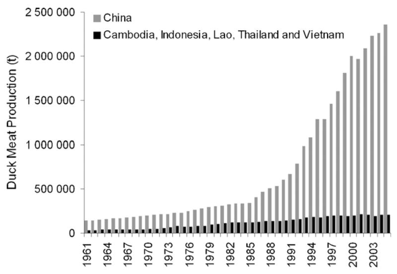
Increase in duck production 1961–2005.
In previous work, the geospatial distribution of HPAIH5N1 outbreaks in Thailand during the second wave of disease outbreaks was analysed, using outbreaks reported from the second half of 2004 to mid 2005 (Gilbert et al., 2006). The results demonstrated a very strong association between HPAI outbreaks and the density of free grazing ducks. There were approximately 13 million free grazing ducks in Thailand with the traditional husbandry characterized by frequent rotation of duck flocks in post harvest rice paddy fields, feeding on leftover rice grains, insects and snails as part of an integrated pest management system (e.g. Teo, 2001). These results also suggested that post-harvest rice paddy fields, which are equally attractive to wild birds and poultry, may have actedas a meeting point between the two. With laboratory studies indicating that domestic ducks may develop HPAI H5N1 virus sub-clinical infections (Hulse-Post et al., 2005), the frequent movements of duck flocks, brought together in night shelters which are often located within villages, and from where live birds and eggs enter the market chain, made healthy ducks important potential virus transmitters and amplifiers of infection (Songserm et al., 2006).
The duck production cycle is closely intertwined with rice cropping because the latter provides the duck feed. Most rice fields in the eastern part of Thailand produce only one crop per year whereas crops located in the central plains permit the production of two or even three crops per year. Exploratory analysis of the duck-rice associations suggested that the double rice crop areas sustain the free grazing duck system, because these crop areas provide year-round feed in the form of post-harvest rice paddy fields. In recent years, substantial progress has been achieved in both satellite sensor capability and data analysis methods application to predict rice crop distributions. For example, it is nowadays possible to routinely map and monitor rice paddy agriculture (Xiao et al., 2005, 2006) and cropping intensity in Asia, using images from the moderate resolution imaging spectroradiometer (MODIS) sensor onboard the NASA Terra satellite. The satellite-based algorithms permit the production of maps and monitoring of cropping intensity, the crop calendar (planting and harvesting dates) and irrigation practices at moderate spatial resolution (250–500 m) and in near-real time fashion.
The objective of this study was two-fold. First, it aimed to characterise the association between duck numbers and the availability of harvested rice paddy fields, using duck census and contemporal rice statistics in Thailand. Second, the study aimed to quantify the geospatial association between free grazing duck census and rice production intensity as predicted by Xiao et al. (2006) rice detection algorithm. This information could be applied to predict the areas at risk of HPAI in Thailand. In complement, the discussion also addresses how similar method could be applied to other countries in Southeast Asia, some of which with identical rice-duck farming associations, but where agricultural statistics are only available at coarse spatial (e.g. national or provincial levels) and/or temporal resolution (e.g. at annual scale).
2. Material and methods
Duck census data were collected from October to mid-November 2004 during the “X-ray” survey, organised by the Department of Livestock Development (DLD, Bangkok, Thailand) and involving the participation of several hundreds of thousands inspectors searching door-to-door for evidence of HPAI presence. These inspectors collected detailed information on domestic poultry numbers and species in each and every farm and household. For the present study two poultry variable were extracted from the “X-ray” survey database: farm ducks which includes meat and layer ducks raised in farms in confined conditions, and free grazing ducks (in the rest of this paper, free grazing ducks explicitly refers to domestic ducks, raised in open flocks, counting mostly more than one thousand birds, for egg production and, to a lesser extent, for meat).
Statistics on rice were obtained from the Department of Agriculture Extension (Minister of Agriculture and Cooperative, Bangkok, Thailand), and included monthly data on the surface area newly planted, under crop or harvested, for each administrative unit. Separate data were available for the first and second rice crop. Data availability for the first crop which accounted for nearly 70 of total rice production, showed much spatial heterogeneity (some data were available only at the province level, others at district level whilst data were lacking for some provinces). On the contrary, data on the second crop season were much more comprehensive, all grouped at the district level.
Images from the moderate resolution imaging spectroradiometer (MODIS) onboard the Terra satellite were used to map cropping intensity and rice paddy agriculture in 2004. MODIS Land Science Team provides standard 8-day composite of surface reflectance product (MOD091A1) to users. Each 8-day composite includes estimates of surface reflectance of the seven spectral bands at 500 m spatial resolution: blue (459–479 nm), green (545–565 nm), red (620–670 nm), near infrared (NIR1: 841–875 nm; NIR2: 1230–1250 nm), and shortwave infrared (SWIR1: 1628–1652 nm, SWIR2: 2105–2155 nm). MOD09A1 composites are generated in a multi-step process that first eliminates pixels with a low score or low observational coverage, and then selects an observation with the minimum blue-band value during the 8-day period (http://modis-land.gsfc.nasa.gov/MOD09/MOD09ProductInfo/MOD09_L3_8-day.htm). The composites still have reflectance variations associated with the bidirectional reflectance distribution function (BRDF). MOD09A1 also includes quality control flags to account for various image artefacts (e.g. clouds, cloud shadow).
A unique physical feature of rice paddy fields is that rice is grown on flooded soils, and rice paddy fields are a mixture of open water and green rice plants during the early part of the growing season. To identify the changes in the mixture of surface water and green vegetation in rice paddy fields over time requires spectral bands or vegetation indices that are sensitive to both water and vegetation. Three vegetation indices, normalized different vegetation index (NDVI), enhanced vegetation index (EVI) and land surface water index (LSWI), are sensitive to changes in leaf area index, leaf chlorophyll content, and leaf water content and soil moisture, respectively. A satellite-based mapping algorithm, based on temporal profile analysis of these three vegetation indices, was developed to identify and track those image pixels that experienced flooding and rice transplanting over time (Xiao et al., 2005, 2006). In this study 46 8-day composites of MODIS surface reflectance product (MOD09A1) in 2004 were used as input data for the mapping algorithm.
3. Results
Rice planting in Thailand took place mainly from May to October for the first rice crop, and from November to April for the second (Fig. 2). The planting peak was in July. The period showing the largest planted area ran from July to December and from January to June, for the second crop. The harvest mainly took place in November and December, for the first crop. Much lower harvest levels took place during the remaining months. The second crop harvest was scattered over time, with some basic level of harvest taking place from February to July. The surface area planted for the first crop by far exceeded that of the second, except for the central plains, where most second crop plantings were concentrated (Fig. 3).
Fig. 2.

Monthly distribution of the areas or rice paddy fields newly planted, under crop and harvested in Thailand (the actual data run from April 2003 to 2004 for the first crop, and September 2003 to 2004 for the second crop).
Fig. 3.

Distribution of farm duck density (A), free grazing duck density (B), second rice planting areas (C; from statistical records) and of the number of rice crops per year (D; as predicted from remote sensing).
The visual match between the geographical distribution of free grazing ducks (Fig. 3B) and second rice crop as estimated from statistical records (Fig. 3C), or from remote sensing (Fig. 3D), was very strong especially if one considers that the three data sets concerned originate from three entirely different sources: (i) the X-ray door-to-door survey data on the poultry population census in late 2004; (ii) the official current Thai agriculture statistics on rice; (iii) a rice detection algorithm developed in an independent study seeking to map rice agriculture across Southeast Asia (Xiao et al., 2006). In particular, there was a strong visual match between the contours or demarcation of the high density free grazing duck areas, and areas where two or more rice crops were produced (Fig. 3B and D, respectively).
This visual impression was supported by a quantitative assessment of the association between the monthly amount of harvested rice paddy fields resulting from the second crop (expressed in terms of total number of months with second crop harvested rice paddy fields by district) and the corresponding local free grazing duck population (Fig. 4A, linear regression model: F1,924 = 613.5, p < 0.001, R2 = 0.3984). In contrast, the same plot for the number of ducks in farm and second rice crop showed a very weak association (Fig. 4B, linear regression model: F1,924 = 110.3, p < 0.001, R2 = 0.1057), with large number of ducks in areas where there is no second crop harvest. We verified the significance of these associations in presence of spatial autocorrelation using the modified t-test (Dutilleul, 1993), and both associations were found to be significant (p < 0.001, and p = 0.0039, respectively).
Fig. 4.

Box-plot of the log-transformed number of free grazing ducks (A) and farm ducks (B) by district, and the total number of months during which second crop rice harvest takes place at the district level.
The distribution of free grazing duck density is inflated in the zero category and the analysis of the relationship with rice crop intensity predictions from remote sensing therefore requires stratification, taking a threshold of 5 animals/km2 in order to obtain a close to normal distribution of free grazing duck density (Fig. 5A). There was a highly significant statistical association between the number of crop cycles estimated from remote sensing and the presence or absence of >5 free grazing ducks/km2 (Fig. 5B; binomial GLM: −2LL model = 12845, −2LL constant = 15,293, χ2 = 2448, d.f. 28,043, p < 0.001). In those areas where free grazing ducks were present at a density >5 animals/km2, the quantitative association was also strong and significant (Fig. 5C; linear regression model: F1,2192 = 503.8, p < 0.001, R2 = 0.1869).
Fig. 5.

Quantitative associations between free grazing duck (FGD) density and the number of rice crops as predicted by remote sensing. (A) Histogram of free-grazing duck density (Log) in pixels with >5 animals/km2; (B) association between rice production intensity and the proportion of pixels with FGD populations >5 animals/km2; (C) association between rice production intensity and FGD density for pixels with an FGD density of >5 animals/km2.
4. Discussion
The analyses showed two main results. First, there was a clear and strong geographical correlation between the distribution of free grazing ducks and that of second crop rice production (mostly in the dry season), i.e. irrigated rice paddy fields. Second, the number of rice crop per year predicted by remote sensing was strongly correlated with free grazing duck density and, thereby, HPAI presence during the 2004/2005 epidemic wave.
Rice is the main feed for ducks and areas with a single crop can sustain one main duck production cycle with feeding concentrated during the main rice harvest in November and December. This duck cycle meets the massive demand for duck meat at the time of the Chinese New year (late January–early February). For the remainder of year, producing ducks in areas with a single crop cycle is costly, because of the lack of feed from rice paddy fields.
In the central plain of Thailand, the hydrology and network of irrigation canals permit the production of up to three cycles of rice per year (Fig. 3D). The results demonstrated that it is in these areas that free grazing ducks were raised in the highest numbers. Free grazing ducks rely on the availability of harvested rice paddy fields where flocks feed on leftover rice grains. Any shortage in space or time in the availability of these harvested rice paddy fields results in additional costs, such as moving duck flocks to distant areas where other rice fields are available, or temporarily buying and bringing feed to the ducks. This explains why the highest numbers of free grazing ducks were found in areas with the highest number of month of rice harvest (Fig. 4A). In contrast, ducks in farm can be fed with imported or stocked rice, or concentrate feed, and their number was therefore only loosely related to the number of month with rice harvest (Fig. 4B). Free grazing duck husbandry in Thailand is popular as it represented in 2004 nearly 13 millions birds distributed in the central plains (mostly layer ducks), whilst ducks in farm represented a total of 20 millions birds. Free grazing ducks could be brought to rice post harvest fields in numbers as high as 4000 birds/ha, rotated every 2 days or so, often by means of a truck. Given the indication that the 2004 HPAI outbreaks were strongly associated with free grazing ducks, this husbandry practice was subjected to much focus in terms of HPAI surveillance and preventive measures, including (i) registration and surveillance of all flocks (when HPAI H5N1 positive, stamping out and compensation followed), (ii) pre-movement testing, and (iii) provision of incentives for improved biosecurity and shift from free grazing husbandry into farm ducks. These measures were arguably effective in reducing the number of HPAI outbreaks during 2005, when HPAI was still present in Thailand but at a much lower level (Gilbert et al., 2006). In 2005/2006, Thailand was still in a transition phase when, despite incentive measures, free grazing duck were still found in high numbers in the central plains, and when duck flocks were still undertaking sub-provincial movements. In the future, the transformation of the sector toward the raising of ducks in farms is very likely to affect the distribution of free grazing ducks, and to reduce their role in HPAI spread and persistence.
It is well established that agricultural intensification has a significant effect on wild bird populations, distribution, migratory routes and stop-over sites (e.g. Van Eerden et al., 2005). The concentration of free grazing duck population in the central plain wetland of Thailand has undoubtedly resulted in much numerous contacts with the wild avifauna. There might be a strong seasonality in the number of those contacts because the spatial distribution of wetlands in Southeast Asia is strongly affected by the monsoon. For example, some lakes like Tonle Sap Lake in Cambodia may seasonally double in surface area. Thus, during the dry season, the irrigated wetlands, i.e. rice paddy fields, form the important wetland habitat left for wild waterfowls, thus increasing the chances of virus transmission to and from the local poultry. Hence, understanding the spatiotemporal distribution pattern of HPAI in Thailand requires that one not only account for the dynamic free grazing duck and rice production, but also incorporates the seasonality of wetlands and water bodies. Several studies have applied satellite imagery to map wetland distribution at 1 km spatial resolution, e.g., IGBP DIScover, GLC2000 and MODIS Land datasets (Friedl et al., 2006), but these algorithms require fine tuning. In addition to these efforts toward better wetland mapping, field studies should be carried out to better assess the relationships between the distribution of wetlands, resident and migratory birds distribution, and domestic poultry.
Interestingly, the overlap of rice crops and wetlands as encountered in the central plains of Thailand are also found in Vietnam (the Mekong and Red river deltas). These conditions only occur to a limited extent in Cambodia and are nearly absent from Lao, both countries where HPAI was introduced but soon vanished (OIE records). One may hypothesise that mixed duck and rice farming predisposed for HPAI persistence. Cambodia and Lao PDR count 7 and 2.6 million ducks, respectively. These low populations as well as relatively low human and poultry density may have facilitated the disease control as compared to Thailand and Vietnam where duck populations are much higher (33 and 69 million ducks, respectively). In both Vietnam and Indonesia, preliminary studies indicated links between HPAI and duck concentrations. The results showed that remote-sensing derived rice crop intensity information correlated well with free grazing duck density and this finding could be important for HPAI risk assessment in other countries where poultry statistics are only available at a coarse scale. The registration and pre-movement testing of free grazing ducks as implemented in Thailand is believed to have played a role in the containment of the HPAI problem. In Indonesia, poultry census statistics are at a coarse spatial and temporal scale and the control of HPAI is correspondingly difficult. Remote sensing may help the construction of HPAI risk maps in Indonesia and Vietnam.
Acknowledgments
The authors are grateful to Rob Wallace for stimulating discussions on the topic.
References
- Dutilleul P. Modifying the t-test for assessing the correlation between two spatial processes. Biometrics. 1993;49:305–314. [Google Scholar]
- Friedl MA, McIver DK, Hodges JCF, Zhang XY, Muchoney D, Strahler AH, Woodcock CE, Gopal S, Schneider A, Cooper A, Baccini F, Gao C, Schaaf C. Global land cover mapping from MODIS: algorithms and early results. Remote Sens Environ. 2006;83:287–302. [Google Scholar]
- Gilbert M, Chaitaweesub P, Parakamawongsa T, Premashtira S, Tiensin T, Kalpravidh W, Wagner H, Slingenbergh J. Free-grazing ducks and highly pathogenic avian influenza, Thailand. Emerg Infect Dis. 2006;12:227–234. doi: 10.3201/eid1202.050640. [DOI] [PMC free article] [PubMed] [Google Scholar]
- Hulse-Post DJ, Sturm-Ramirez KM, Humberd J, Seiler P, Govorkova EA, Krauss S, Scholtissek C, Puthavathana P, Buranathai C, Nguyen TD, Long HT, Naipospos TSP, Chen H, Ellis TM, Guan Y, Peiris JSM, Webster RG. Role of domestic ducks in the propagation and biological evolution of highly pathogenic H5N1 influenza viruses in Asia. Proc Natl Acad Sci USA. 2005;102:10682–10687. doi: 10.1073/pnas.0504662102. [DOI] [PMC free article] [PubMed] [Google Scholar]
- Li KS, Guan Y, Wang J, Smith GJD, Xu KM, Duan L, Rahardjo AP, Puthavathana P, Buranathai C, Nguyen TD, Estoepangestie ATS, Chaisingh A, Auewarakul P, Long HT, Hanh NTH, Webby RJ, Poon LLM, Chen H, Shortridge KF, Yuen KY, Webster RG, Peiris JSM. Genesis of a highly pathogenic and potentially pandemic H5N1 influenza virus in eastern Asia. Nature. 2004;430:209–213. doi: 10.1038/nature02746. [DOI] [PubMed] [Google Scholar]
- Songserm T, Jamon R, Sae-Heng N, Meemak N, Hulse-Post DJ, Sturm-Ramirez KM, Webster RG. Domestic ducks and H5N1 influenza epidemic, Thailand. Emerg Infect Dis. 2006;12:575–581. doi: 10.3201/eid1204.051614. [DOI] [PMC free article] [PubMed] [Google Scholar]
- Teo SS. Evaluation of different duck varieties for the control of the golden apple snail (Pomacea canaliculata) in transplanted and direct seeded rice. Crop Prot. 2001;20:599–604. [Google Scholar]
- Van Eerden MR, Drent RH, Stahl J, Bakker JP. Connecting seas: Western Palaearctic continental flyway for water birds in the perspective of changing land use and climate. Global Change Biol. 2005;11:894–908. [Google Scholar]
- Xiao X, Boles S, Frolking S, Li C, Babu JY, Salas W, Moore B. Mapping paddy rice agriculture in South and Southeast Asia using multi-temporal MODIS images. Remote Sens Environ. 2006;100:95–113. [Google Scholar]
- Xiao XM, Boles S, Liu JY, Zhuang DF, Frolking S, Li CS, Salas W, Moore B. Mapping paddy rice agriculture in southern China using multi-temporal MODIS images. Remote Sens Environ. 2005;95:480–492. [Google Scholar]