Abstract
The Hongshan societies of northeastern China are among East Asia’s earliest complex societies. They have been known largely from elaborate burials with carved jades in ceremonial platforms. The most monumental remains are concentrated in a “core zone” in western Liaoning province. Residential remains are less well known and most investigations of them have been in peripheral regions outside the core zone. Recent regional settlement pattern research around the well known ceremonial site of Dongshanzui has begun to document the communities that built and used Hongshan core zone monuments and to assess their developmental dynamics. The core zone, like the Hongshan periphery, appears to have been organized into a series of small chiefly districts within which ceremonial activities were important integrative forces. Their estimated populations of less than 1,000 are not much larger than those of districts in the periphery, and the evidence does not suggest that these districts were integrated into any larger political entity. The greater elaboration of core zone monumental architecture is thus not attributable to demographically larger communities or to larger-scale political integration. Future research should focus on documenting the organization of statuses and economic activities within these core zone communities to assess potential differences from peripheral communities in these regards.
Keywords: chiefdoms, comparative archaeology, China, Hongshan communities, regional settlement
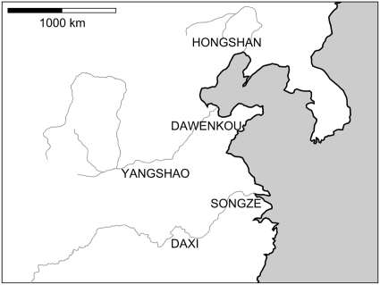
At approximately the beginning of the fourth millennium B.C., groups of relatively complex societies founded on the sedentary cultivation of rice and/or millets flourished in widely separated regions of eastern Asia (Fig. 1). Middle to Late Yangshao societies were spread through the middle reaches of the Yellow River valley. Farther downstream were the Dawenkou societies. Daxi societies were located approximately 500 km to the south in the middle Yangzi River valley. Communities that transcend the scale of the local social group were consolidated in all three regions around central towns with substantial walls and moats. Public structures and elaborate residences testify to elite political activities. Burials with substantial amounts of utilitarian objects and personal adornments are taken to indicate social inequalities. At approximately the same time, some burials of the Songze societies of the Yangzi River delta included not only utilitarian goods, but also jade carvings of clear symbolic importance. Probable Songze central towns have ceremonial architecture, but major defensive works are not known. All these societies might loosely be called chiefdoms, but the basis of their social inequalities differed, with symbols and ritual activities at center stage in Songze societies, and economic and military affairs more central to Yangshao, Dawenkou, and Daxi social dynamics.
Fig. 1.
Complex societies of eastern Asia at approximately the beginning of the fourth millennium B.C.
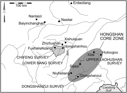
One other group of fourth millennium B.C. societies in eastern Asia had comparable social inequalities and sociopolitical scale. Hongshan societies, dated between 4,500 and 3,000 B.C. in the Liao and Daling river valleys in northeast China, are also known mostly from burials and monumental architecture. Unlike Yangshao, Dawenkou, and Daxi societies, massive walls, moats, and elaborate residences are unknown. As in Songze societies, public architecture was ceremonial, and elaborate burials with symbolic offerings were placed within these monuments. Such remains are concentrated in a “core zone,” including the sites of Niuheliang, Dongshanzui, and Hutougou (Fig. 2). Most public buildings are low platforms with multiple circular or square tiers providing elevated spaces suitable for ceremonies (1–3). Sometimes hundreds of painted pottery cylinders were incorporated into these platforms. Central burial crypts and smaller slab graves contained offerings almost exclusively of jade: elaborate carvings of supernatural themes, bracelets, cuffs, hair tubes, and ear ornaments. These offerings, and the conspicuous absence of utilitarian objects, suggest ritual specialists (4, 5). A unique wattle and daub structure at Niuheliang with a life-size female statue has been labeled the “Goddess Temple,” and nude, pregnant female figurines have been recovered from other platforms. The Hongshan core zone, then, is distinguished by the largest and most numerous platforms, several unique public structures, and almost all known burials with elaborate jade carvings.
Fig. 2.
Sites and surveys in the Hongshan core zone and its periphery.
Monumental architecture of the core zone has until now been the principal inspiration for accounts of the nature of Hongshan societies. Some have imagined Niuheliang or Dongshanzui as communities of thousands of people or even more (6–8), although much smaller populations could clearly have provided the labor necessary for construction, and the spaces created could not have accommodated so many people. The elaborate platform burials with jade carvings are taken to represent elites in a social hierarchy based less on wealth than on religion because of the symbolic nature of the jades and the scarcity of utilitarian offerings. These elites are sometimes thought of as the ceremonial and political leaders of large, well integrated polities (6, 9–15). Craft specialization has been thought necessary to produce both jade carvings and the pottery cylinders used in platforms (6, 9, 11, 16, 17). Conclusions about population levels, scale of political integration, wealth accumulation, and craft specialization based only on public architecture and elaborate burials, however, are tentative at best. Observations of monuments need to be complemented by analysis of settlement distributions at the regional scale and of households within communities. Such information is, however, extremely sparse for the Hongshan core zone. Surveys of small areas (6, 13, 18) document the remains of public architecture as expected for the core zone, but provide very little information about residential sites. The few houses that have been excavated (1, 2, 19) are circular or square, usually semisubterranean, and approximately 20 m2 in area. They are timber frame constructions with wattle and daub walls, thatch roofs, and central hearths. Storage pits were found both inside and outside the dwellings. Only one or two households are known from any single community, however, and little information is available about their artifact assemblages.
Hongshan Communities
There is more information about Hongshan communities located outside the core zone (Fig. 2). A small-scale survey in the lower Bang River valley documented the presence of site clustering taken to represent one or two small chiefly polities (6, 13). A 1,234-km2 systematic complete-coverage regional settlement study near Chifeng also indicates that Hongshan villages were organized into approximately 20 supralocal communities or districts (20, 21). These districts are visible in the distribution of settlement across the landscape in the form of concentrations of occupation separated by open or more sparsely settled areas. Ranging from 2 to 5 km across, these districts were composed of as many as 10 small local communities (villages or hamlets), often with a larger one in the center. District populations seem not to have exceeded approximately 500 inhabitants. There is no indication of any larger or more central district that dominated others, so each is taken to be a small independent polity.
Habitation sites from various parts of the Hongshan periphery, including Chifeng, have been excavated, among them Hongshanhou, Zhizhushan, Xishuiquan, Xinglonggou, Baiyinchanghan, Nantaizi, Nasitai, and Erdaoliang (22–30). Mostly, the houses at these sites are like those from the core zone. A few, however, at Xishuiquan and Baiyinchanghan are substantially larger, reaching up to 100 m2, and might have been elite residences or communal structures of some sort. At Site 6384 in the lower Bang valley, individual houses were detectable on the surface as ashy circles 4 to 5 m in diameter; 52 of them were organized into multiple rows over an area of 0.5 ha. Artifacts and ecofacts document agriculture (especially millet), plant collecting (especially nuts), pig and sheep husbandry, hunting (especially of deer), spinning, weaving, leather-working, and pottery and stone tool production.
Intensive study at Fushanzhuang has provided comprehensive information about the central community in one of the Chifeng districts (31). Meter-by-meter examination and raking of the surface yielded more than 17,000 sherds and more than 5,000 flaked stone implements, debitage, and other classes of artifacts. The middens encircling Hongshan houses were visible as separate, dense artifact concentrations, often associated with patches of dark ashy soil from burned midden debris. It was thus possible to locate individual households and to compare their artifact assemblages. Proportions of different artifact categories were similar across most households, but some stood out for their high proportions of shovels, hoes, plows, axes, adzes, and grinding slabs and rollers; a few others had high proportions of flakes, flake debris, cores, awls, gravers, and projectile points; yet others had high proportions of biface blanks, hammerstones, abraders, and scraping and chopping tools. These three “packages” of productive tools relate most strongly, respectively, to food production and preparation, initial production of lithic and other tools, and final tool manufacture. The differences in their proportions between households suggest an emerging differentiation of productive activities within this Hongshan community.
Some households at Fushanzhuang were also distinguished for high proportions of relatively undecorated but better finished, fine-paste ceramics that required more labor to make. A few other households had low proportions of these finer wares but high proportions of ceramics with abundant appliqués and incised and painted designs. Despite their decorative elaboration, these latter ceramics were much coarser and less well made; they suggest symbolic importance more than luxury. Fushanzhuang has four rock rubble mounds with sherds of painted pottery cylinders that represent burial platforms like those excavated in the Hongshan core zone, but on a smaller scale. Households with higher proportions of coarse but decorated pottery were mostly located nearest these ritual structures, reinforcing the idea of symbolic importance for this decoration.
It is plausible to interpret the overall patterns of association at Fushanzhuang in terms of several social spheres within the community. Some families might have enjoyed greater prestige but no higher standard of living as a consequence of their connection to ceremonial activities. Other families may have lacked this prestige, but enjoyed greater economic well-being derived from participation in one or the other stage of tool production. No excavations have been carried out at Fushanzhuang, so there are no burial data to connect directly to this interpretation. Burials from elsewhere, however, can easily be interpreted in similar terms. Prestige derived from ritual rather than economic roles has long been attributed to individuals buried in ceremonial platforms with symbolic jade carvings, but with few or no utilitarian goods. Varying standards of living, on the other hand, are more evident in burials not in platforms, without symbolic associations, but with differing quantities of utilitarian ceramics, tools, and ornaments (25–27).
Hongshan Social Dynamics
Attempts to reconstruct the nature of social organization that produced the well investigated monuments of the Hongshan core zone have until now had to depend on leveraging the information just discussed about communities in peripheral parts of the Hongshan area. We could imagine that household, community, and regional organization around core zone monumental sites like Niuheliang and Dongshanzui resembled the patterns of the periphery. If so, then the monuments of the core zone were in local communities like Fushanzhuang that served as central places of numerous small polities like those reconstructed for Chifeng. The ceremonies carried out at the monuments may have been among the activities that drew people to these central places. The individuals buried in platforms with jade offerings in the core zone might correspond to a prestigious, but not wealthy, social sector like that hinted at by the Fushanzhuang evidence, consistent with suggestions by Guo (4) and Lu (5) that these were ritual specialists. Incipient productive differentiation might also have been among central place activities and contributed to differences in economic well being between households, although such specialization of production and wealth accumulation as may have occurred at Fushanzhuang were both clearly on a very minimal scale.
Such an account of Hongshan core zone social dynamics, however, would contradict the idea of political integration across much or all of the Hongshan area, of sustaining communities of thousands of people, of intense craft specialization, and of wealthy and powerful elites in the manner of Yangshao or Dawenkou societies. These ideas spring from the fact that the monuments at places like Niuheliang and Dongshanzui are considerably more numerous, more elaborate, and more impressive than those of peripheral regions like Chifeng. They have not until now been supported by direct evidence of household, community, or regional organization in the core zone, leaving us without sound empirical basis to choose between competing visions of Hongshan societies.
The question of how the societies of the Hongshan core zone came to have such greater monumental expression than those of the periphery strikes at the heart of understanding the developmental dynamics of Hongshan society in general. Were core zone populations denser? Were core zone polities larger? Was economic specialization more intense? Were wealth differences more pronounced? Depending on the answers to these questions, Hongshan societies would be positioned differently vis-à-vis an array of other early complex societies within eastern Asia and beyond.
Results: Hongshan Core Zone Settlement Patterns
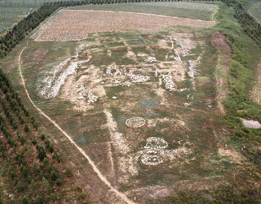
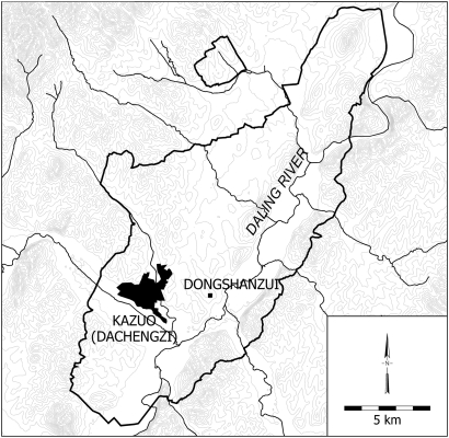
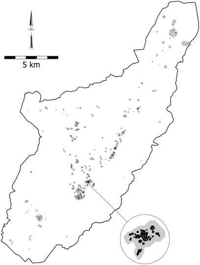
Recent settlement survey of 200 km2 (Fig. 3) around the excavated ceremonial site of Dongshanzui (Fig. 4) has begun to fill in some of the gaps in our knowledge of Hongshan core zone communities. Hongshan occupation was substantial and spread throughout the survey area, with noticeably higher density concentrations in four or five locations. Altogether, 2,466 Hongshan sherds were recovered from collection units totaling an area of 75 ha (Fig. 5). Population of the survey area is estimated at 750 to 1,500 people. This seems like a substantial number of people, but it works out to only about one family per square kilometer. Although population densities across the entire Chifeng survey area were somewhat lower, they reached or exceeded this level in agriculturally favorable areas along valley margins like the area selected for survey around Dongshanzui. Comparison of the only two areas of complete coverage systematic survey, then, does not suggest that the Hongshan core zone had generally higher population densities than peripheral regions.
Fig. 3.
Excavated public architecture at Dongshanzui.
Fig. 4.
Limits of the survey area along the Daling River including the ceremonial site of Dongshanzui and the modern city of Kazuo (Dachengzi).
Fig. 5.
Distribution of Hongshan occupation in the Dongshanzui survey area. Gray shading shows how individual collection units were grouped into local communities, based on the unsmoothed surface in Fig. 6. Even within these clusters, occupation was dispersed, as seen in the enlargement (Inset).
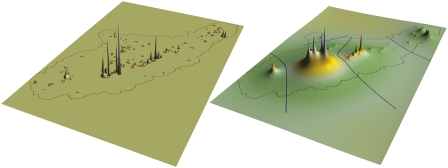
Clusters of collection units demarcating approximately 100 small local communities are fairly readily discernible in an unsmoothed surface (Fig. 6) representing Hongshan population distribution in the Dongshanzui survey area. At least half these “local communities” probably represent nothing more than farmsteads of one or two families. Others are demographically larger, grading into hamlets and at least a few villages with estimated populations on the order of 100 or more. These larger communities are so dispersed that labeling them “villages” may create a false impression of their nature; houses within them were often spread 100 m or more apart (Fig. 5). Some Hongshan villages do seem to have been very compact and nucleated (such as Baiyinchanghan or lower Bang Site 6384), but the scattered nature of Hongshan surface remains in the Dongshanzui survey area and their relatively low densities do not suggest such strong nucleation for any local community. As the same could be said for the Chifeng survey area, it may be that well known nucleated Hongshan villages should be considered atypical. This is clearly not a feature that distinguishes the core zone from more peripheral areas.
Fig. 6.
Surfaces representing Hongshan occupation in the Dongshanzui survey area. Grouping of individual collection units into local communities is shown on the unsmoothed surface (Left). Dividing lines separating supralocal communities, or districts, are shown on the smoothed surface (Right).
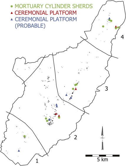
A mathematically smoothed surface of Hongshan occupation in the Dongshanzui survey area (Fig. 6) shows settlement clustering that suggests four distinct supralocal communities or districts into which the approximately 100 local communities group themselves. A fifth district may be represented by the Hongshan occupation in the separate 5-km2 survey area to the north in Fig. 5. This aspect of regional organization, like the nature of local communities, is similar to what was found in the Chifeng survey. In both regions, larger, somewhat denser, and more closely spaced local communities are at the heart of each district. Farther out, more scattered occupation creates sparsely settled buffer zones that separate the districts. In the central portions of each of the four districts are definite or probable remains of Hongshan ceremonial architecture, still visible on the surface even some 6,000 years later (Fig. 7). One of these locations is, of course, the excavated ceremonial complex of Dongshanzui. All four districts in the large survey area also have centrally located collection units with large quantities of the painted pottery cylinders that characteristically adorned Hongshan burial platforms, even though no architectural remains are visible on the surface today in these particular locations (Fig. 7). The Dongshanzui survey area thus provides direct documentation of core zone monuments in central locations in small supralocal communities—just the social setting imagined for them with inspiration from communities in the periphery. The Dongshanzui survey area manifests the more developed character of core zone monumentality: the monuments are more numerous, more elaborate, more varied, and more densely distributed on the landscape than in the periphery. Their social roles and contexts, nonetheless, seem very like those of the less impressive monuments of Chifeng.
Fig. 7.
The four Hongshan districts delineated in the smoothed surface in Fig. 6, with locations of public architecture and high frequencies of mortuary ceramic cylinder sherds in the context of Hongshan occupation in each district.
In these qualitative terms, then, Dongshanzui and Chifeng supralocal communities appear to represent the same kind of social phenomenon, even though the ceremonial aspects of the Dongshanzui districts display greater elaboration. It is thus reasonable to wonder whether these core zone districts were larger and more developed demographically than those of Chifeng. In spatial terms at least, the Dongshanzui districts are slightly larger than those defined for Chifeng: approximately 4 to 8 km across compared with 3 to 5 km across. In Chifeng, district populations ranged from approximately 100 to 400–500; in the Dongshanzui survey area, from 100 to perhaps 700. At least the biggest of the four districts in the Dongshanzui survey area (District 2 in Fig. 7, centered on the Dongshanzui site itself) is thus somewhat larger than any of the Chifeng districts, although it falls far short of the thousands of inhabitants sometimes imagined for core zone polities. These small differences between core zone and periphery in the spatial and demographic scale of districts are dwarfed by the contrast in monumentality. Archaeological evidence of Hongshan ceremonial and burial platforms is vastly more abundant in the Dongshanzui survey area, and some of the Dongshanzui structures are considerably more elaborate than any known for Chifeng. The much more highly elaborated ceremonial aspects of the core zone, then, do not appear to have sprung from greater demographic development than in the periphery. Hongshan districts in both core and periphery had surprisingly small populations.
This reasoning, of course, depends upon taking each Hongshan district as a separate political entity. As noted earlier, however, much larger scale political integration has sometimes been imagined for Hongshan societies. This does not seem to be the case for Chifeng, whose districts are most convincingly interpreted as politically independent entities (32). In Chifeng, no one district’s central place stands out as especially large, so as to suggest that it dominated multiple districts. In spatial terms, no one of the districts with the largest central places had smaller districts arrayed around it as might be expected if they were subunits of an integrated regional economic or political structure.
The 20 districts of Chifeng make such patterns easy to evaluate. With only four districts in the Dongshanzui survey area, the relationships between them are not so immediately clear. For several reasons, however, it does not appear that there was any higher order of political or economic integration that subsumed multiple districts. District 2, containing the Dongshanzui ceremonial site, around which the survey area was drawn, obviously had the largest population. It shows all of the expected evidence of the centripetal forces that draw together a cohesive community a few kilometers across. But the Dongshanzui settlement itself has not turned out to look anything like a political or economic central place dominating a larger region. Although its monuments are surrounded by a substantial amount of residential occupation, it is only one of four distinct occupational peaks visible within District 2 in the smoothed surface in Fig. 6. These peaks correspond to four separate large dispersed local communities, all roughly the same size (and none much larger than the largest local community in District 3). Public architecture is not concentrated into any one of these, but more broadly dispersed across the district. There is thus no convincing candidate for a central place capable of dominating the larger region.
The four districts, moreover, show stronger spatial separation than we would expect if they had been politically or economically integrated. There is no sign that populations across the survey area were drawn toward a center in District 2. Instead, the sparsely occupied zones that separate the districts are quite apparent as areas that population was drawn away from toward the demographic centers of gravity that lay in opposite directions. Larger-scale political or economic integration has a very different appearance in such smoothed surfaces; it is regularly reflected as a single, strongly dominant demographic peak with an inverted funnel shape that engulfs the much smaller peaks of subsidiary centers (32).
Each district also had its own ceremonial facilities, all of basically the same character (Fig. 7); essential ritual functions seem to have been separately served within each district. All districts are highly centralized internally; their populations are strongly drawn toward their centers. When their degrees of centralization are assessed using the B coefficient (33), values range from a high of 0.91 for District 1 down to 0.63 for District 4, quite similar to B values for districts in the Chifeng survey area. The fact that the entire Dongshanzui survey area taken together has an even lower B value of 0.42 is further evidence that the districts were not well integrated into a single regional political or economic entity. Such integration at a scale larger than that of the individual district, then, does not seem to account for the greater monumentality of core zone sites.
The apparent lack of regional political or economic integration of districts, however, does not imply an absence of interaction between them. After all, a recognizable Hongshan style of pottery and other material culture was shared not only by these four districts, but also by Hongshan populations hundreds of kilometers away. Estimated district populations are not large enough even to have been biologically self-sustaining—mates would surely often have come from other districts. For these and other reasons it is clear that social interaction of some kinds crossed district boundaries, although interaction between districts would have been less intense and probably of a different character than interaction within districts. One form that this interdistrict interaction seems likely to have taken was ceremonial, and a system of larger-scale regional ceremonial interaction might be reflected in the existence of a center with more elaborate or qualitatively different facilities that were the site of special ritual activities participated in by people who came from other districts. The complex of ceremonial architecture at multiple localities around Niuheliang, discussed further later, is the best candidate for such a center that could have played a major role in sustaining long-term contacts between districts that were otherwise self-sufficient in political and economic terms.
Regional settlement analysis, of course, customarily consists of a series of palimpsests each representing a different period. This is true even with the finest chronological resolution archaeologically obtainable, but it becomes of special concern with long periods such as Hongshan, which covers 1,500 years. It is possible, for example, that Dongshanzui District 2 appears to have had a larger population than the other districts only because it was occupied for a longer portion of the Hongshan period, allowing more time for occupational debris to accumulate. Imagining such a palimpsest effect would only strengthen the conclusion above that District 2 was not a higher-order center integrating multiple districts economically or politically. Similarly, longer-term occupation generally in the core zone might contribute to the appearance of slightly larger populations in some districts there, and, if so, even this small contrast with districts in the periphery would diminish. Neither the lack of contrast between core zone and peripheral districts, then, nor the apparent lack of political and economic integration of multiple districts, is attributable to the length of the Hongshan period.
The Dongshanzui survey has made it clear that, compared with other early chiefly polities, Hongshan districts in both core zone and periphery were demographically quite small. Many Dawenkou and Middle to Late Yangshao supralocal communities were larger (more than 1,000–2,000 people), and a few Late Yangshao ones were several times larger. Outside Asia, several well known chiefdoms had district populations ranging from 4,000 or 5,000 into the tens of thousands: Cahokia, Moundville, Middle Formative Basin of Mexico, Regional Classic Alto Magdalena, Early Intermediate Santa Valley, and precontact Hawai’i (34). The well documented chiefly district of San José Mogote in the Valley of Oaxaca joins Hongshan at the low end of the demographic scale. Despite the small demographic scale, substantial social hierarchy is clear in both Hongshan burials and Oaxaca elite residential architecture (35). The San José Mogote district, however, is the only one of this size in Oaxaca, whereas Hongshan districts might have numbered in the hundreds if the entire area across northeastern China where Hongshan pottery is found showed patterns like those in the Dongshanzui and Chifeng survey areas.
Discussion
The first systematic settlement pattern evidence from the Hongshan core zone has revealed a pattern of local and supralocal community development very like that previously known for the periphery. Numerous farmsteads were scattered across the landscape, but most of the regional population lived in larger local communities. These larger local communities were not compact, nucleated hamlets and villages, but dispersed aggregations of occupation sometimes stretching across hundreds of meters. Local communities were grouped into multiple districts which, while clearly interacting with each other, seem not to have been politically integrated. Each had its own ceremonial facilities. The largest district, around the Dongshanzui ceremonial center, had a population not appreciably larger than districts known for the periphery. Districts in the Dongshanzui survey area were closely spaced, creating elevated regional population densities, although no more than was the case in parts of the Chifeng survey area. The more elaborate expression of ceremonial activity and social hierarchy in the Hongshan core zone thus does not appear to be a consequence of higher population density, larger populations, more centralized communities, or larger-scale political integration. Attention can now turn to other productive subjects for research.
It could be that the greater monumentality and elaboration of social hierarchy of the Hongshan core zone derived from greater economic development. In the periphery, Fushanzhuang provides support for only a modest degree of specialized production and exchange, as well as for similarly modest differentiation with regard to wealth or standard of living. It has not previously been possible to evaluate these aspects of core zone communities, but the Dongshanzui survey has now identified numerous zones of occupation where intensive surface collection and stratigraphic testing programmed for 2010 and 2011 will collect direct evidence of patterns of economic activities and statuses at the household level. If specialized production and differences between households in standard of living are found to a greater degree at Dongshanzui than at Fushanzhuang, the idea that greater economic development underwrote the monumentality of the core zone will be supported. This work also provides an opportunity to refine chronology through radiocarbon dating and stratigraphic analysis of ceramics; refined chronology will facilitate better delineation of patterns of community growth.
The Dongshanzui survey situates core zone monuments in the context of the living communities that built and used them. Only 30 km to the northwest, the Niuheliang complex continues to stand out as a particularly impressive concentration of Hongshan ceremonial localities, including some very unusual facilities such as the Goddess Temple. Niuheliang may have played a uniquely important role in the religious integration of populations all across the Hongshan area, perhaps as a pilgrimage center visited by many but with little resident local population (6, 11, 17). The Dongshanzui survey has provided the comparative baseline needed for assessing the relationship between Niuheliang’s monuments and any surrounding population through future survey.
Methods
The Dongshanzui survey area consisted of 200 km2 of agriculturally productive territory along the Daling River valley, upstream and downstream of the ceremonial site of Dongshanzui. An additional noncontiguous 5 km2 was surveyed around a known Hongshan occupation 3 km to the north. Field teams walked the landscape at intervals of 50 m. The locations and boundaries of surface scatters of artifacts were recorded on satellite images with a resolution of 2.5 m printed at a scale of 1:5,000. All artifact scatters yielding two or more ancient sherds within a 50 × 50-m area were recorded. Surface collections of ceramics were made in areas not exceeding 50 × 50 m. Any surface scatter larger than this size was subdivided into multiple collection units. In the center of any collection unit where surface sherd densities were 0.5 per m2 or greater, a systematic collection was made in a dog-leash circle with a radius of 1.8 m (for an area of 10 m2). If fewer than 20 sherds were obtained, additional circles were collected until this goal was reached. In collection units where surface sherd densities were less than 0.5/m2, general collections were made consisting of the first 25 sherds observed. Where sherd densities were very low, fewer than 25 sherds were observed within a few minutes of searching, and collections were correspondingly smaller. Intensive cultivation meant that conditions of surface visibility were generally excellent. Recent sedimentation in the flat valley floor would obscure surface archaeological remains, but the valley floor is extremely inhospitable to settlement because of frequent flooding, and this appears to have been the case throughout the past 10,000 years or so. It is thus extremely unlikely that this zone was much occupied in ancient times.
Collection units were not grouped into “sites” but were themselves the units of analysis. Population estimates were based on both area and density of surface artifact scatters following the same approach used in Chifeng (36, 37). The representation of distance-interaction principles in smoothed and unsmoothed density surfaces was the basis of delineating communities at both supralocal and local scales (32).
Acknowledgments
The settlement patterns research around Dongshanzui discussed here was carried out in May and June 2009, as a collaboration between the Liaoning Province Institute of Archaeology and the universities of Hawai'i and Pittsburgh. Permission for the research was issued by the State Administration of Cultural Heritage. The research would not have been possible without the active participation of the Kazuo County Bureau of Culture and the Kazuo County Museum. Support was provided by National Science Foundation Awards BCS-0849519 and BCS-0849758, National Geographic Society Grant 8623-09, and the American Council of Learned Societies with funding from the Henry Luce Foundation.
Footnotes
The authors declare no conflict of interest.
References
- 1.Chaoyang Shi WenwubuLiaoning Sheng Wenwu Kaogu Yanjiusuo . Niuheliang Yizhi. Beijing: Xueyuan Chubanshe; 2004. [Google Scholar]
- 2.Guo Dashun, Zhang Keju. Liaoning sheng Kazuo xian Dongshanzui Hongshan wenhua jianzhu qunzhi fajue jianbao [A brief report on excavations at the Hongshan culture architectural complex of Dongshanzui, Kazuo County, Liaoning Province] Wenwu. 1984;1984(11):1–11. [Google Scholar]
- 3.Fang Dianchun, Liu Baohua. Liaoning Fuxin xian Hutougou Hongshan wenhua yuqi mu de faxian [The discovery of Hongshan culture graves with jade artifacts at Hutougou, Fuxin County, Liaoning] Wenwu. 1984;1984(6):1–5. [Google Scholar]
- 4.Guo Dashun. Hongshan wenhua de “weiyuweizang” yu Liaohe wenming qiyuan tezheng zai renshi [The Hongshan culture’s “exclusive interment of jade” and a reconsideration of Liao River civilizaton] Wenwu. 1997;1997(8):20–26. [Google Scholar]
- 5.Lu Xueming. Hongshan Wenhua Muzang Yanjiu. MA Thesis. P.R. China: Jilin Univ, Changchun; 2001. [Google Scholar]
- 6.Li Xinwei. Development of Social Complexity in the Liaoxi Area, Northeast China. Oxford: Archaeopress; 2008. [Google Scholar]
- 7.Nelson SM. In: Ancestors for the Pigs: Pigs in Prehistory. Nelson SM, MASCA Research Papers in Science and Archaeology, editor. Philadelphia: Univ. of Pennsylvania Museum of Archaeology and Anthropology; 1998. No. 15, pp 99–107. [Google Scholar]
- 8.Nelson SM. Hongshan in. In: Peregrine PN, Ember M, editors. Encyclopedia of Prehistory, Volume 3: East Asia and Oceania. New York: Kluwer/Plenum; 2001. pp. 77–81. [Google Scholar]
- 9.Childs-Johnson E. Jades of the Hongshan culture: The dragon and fertility cult worship. Arts Asiatiques. 1991;46:82–95. [Google Scholar]
- 10.Drennan RD, Peterson CE. Patterned variation in prehistoric chiefdoms. Proc Natl Acad Sci USA. 2006;103:3960–3967. doi: 10.1073/pnas.0510862103. [DOI] [PMC free article] [PubMed] [Google Scholar]
- 11.Guo Dashun. In: The Archaeology of Northeast China: Beyond the Great Wall. Nelson SM, editor. London: Routledge; 1995. pp. 21–64. [Google Scholar]
- 12.Nelson SM. In: Ideology and the Formation of Ancient States. Claessen HJM, Oosten JG, editors. Leiden: Brill; 1996. pp. 153–169. [Google Scholar]
- 13.Li Xinwei. In: Bulletin of the Indo-Pacific Prehistory Association, No. 24 (The Taipei Papers, Vol. 2) Bellwood P, Bowdery D, editors. Canberra: Australian National Univ; 2004. pp. 103–112. [Google Scholar]
- 14.Su Bingqi. Liaoxi guwenhua gucheng guguo [Ancient cultures, ancient cities, ancient states in the western Liao region] Wenwu. 1986;1986(8):41–44. [Google Scholar]
- 15.Yu Weichao, Yan Wenming, Zhang Zhongpei, Li Yangsong. Zuotan Dongshanzui yizhi [An informal discussion of the Dongshanzui site] Wenwu. 1984;1984(11):12–21. [Google Scholar]
- 16.Hua Yubing. Niuheliang nushenmiao pingtai dongpo tongxingqiqun yicun fajue jianbao [A brief report on the remains of a group of ceramic cylinders excavated from the east slope of the Goddess Temple platform at Niuheliang] Wenwu. 1994;1994(5):54–59. 82. [Google Scholar]
- 17.Nelson SM. In: Bulletin of the Indo-Pacific Prehistory Association, No. 16 (Changnan Papers, Vol. 3) Bellwood P, Tinoston D, editors. Canberra: Australian National Univ; 1997. pp. 57–62. [Google Scholar]
- 18.Shao Guotian. Zhongguo Beifang Gudai Wenhua Guoji Xueshu Yantaohui Lunwenji. Beijing: Zhongguo Wenshi Chubanshe; 1995. pp. 97–102. [Google Scholar]
- 19.Tian Guangjin. Neimenggu shiqi shidai–qintong shidai kaogu faxian he yanjiu [Archaeological discoveries and research from the Stone Age to the Bronze Age in Inner Mongolia] Neimenggu Wenwu Kaogu. 1992;1992(1/2):1–20. [Google Scholar]
- 20.Chifeng International Collaborative Archeological Research Project . Regional Archeology in Eastern Inner Mongolia: A Methodological Exploration. Beijing: Science Press; 2003. [Google Scholar]
- 21.Chifeng International Collaborative Archeological Research Project Settlement Patterns in the Chifeng Region. Pittsburgh: Center for Comparative Archaeology, Univ. of Pittsburgh; 2010. in press. [Google Scholar]
- 22.Balinyou Qi Bowuguan Neimenggu Balinyou qi Nasitai yizhi diaocha [Survey of the Nasitai site, Balinyou Banner, Inner Mongolia] Kaogu. 1987;1987(6):507–518. [Google Scholar]
- 23.Hamada Kosaka, Mizuno Seiichi. Chifeng Hongshanhou. Tokyo: Far Eastern Archaeology Society of Japan; 1938. [Google Scholar]
- 24.Neimenggu Wenwu Kaogu Yanjiusuo . In: Neimenggu Wenwu Kaogu Wenji. Wei Jian., editor. Vol. 1. Beijing: Zhongguo Daibaike Jinshu Chubanshe; 1994a. pp. 96–113. [Google Scholar]
- 25.Wei Jian., editor. Neimenggu Wenwu Kaogu Wenji. Vol. 1. Beijing: Zhongguo Dabaike Quanshu Chubanshe; 1994b. pp. 87–96. [Google Scholar]
- 26.Jian Wei., editor. Neimenggu Wenwu Kaogu Yanjiusuo. Neimenggu Wenwu Kaogu Wenji. Vol. 2. Beijing: Zhongguo Daibaike Jinshu Chubanshe; 1997. pp. 53–77. [Google Scholar]
- 27.Neimenggu Wenwu Kaogu Yanjiusuo . Baiyinchanghan: Xinshiqi Shidai Yizhi Fajue Baogao. Beijing: Kexue Chubanshe; 2004. [Google Scholar]
- 28.Zhongguo Shehui Kexueyuan Kaogu Yanjiusuo Neimenggu Gongzuodui Chifeng Zhishushan yizhi de fajue [Excavation of the Zhizhushan site, Chifeng] Kaogu Xuebao. 1979;1979(2):215–244. [Google Scholar]
- 29.Zhongguo Shehui Kexueyuan Kaogu Yanjiusuo Neimenggu Gonzuodui Chifeng Xishuiquan Hongshan wenhua yizhi [The Hongshan culture site of Xishuiquan, Chifeng] Kaogu Xuebao. 1982;1982(2):183–193. [Google Scholar]
- 30.Zhongguo Shehui Kexueyuan Kaogu Yanjiusuo Neimenggu Di Yi Gonzuodui Neimenggu Chifeng shi Xinglonggou juluo yizhi 2002–2003 nian de fajue [Excavations in 2002–2003 at the Xinglonggou settlement site, Chifeng city, Inner Mongolia] Kaogu. 2004;2004(7):3–8. [Google Scholar]
- 31.Peterson CE. “Crafting” Hongshan Communities? Household Archaeology in the Chifeng Region, Eastern Inner Mongolia, PRC. PhD dissertation. Pittsburgh: Univ. of Pittsburgh; 2006. [Google Scholar]
- 32.Peterson CE, Drennan RD. Communities, settlements, sites, and surveys: Regional-scale analysis of prehistoric human interaction. Am Antiq. 2005;70:5–30. [Google Scholar]
- 33.Drennan RD, Peterson CE. In: The Neolithic Demographic Transition and Its Consequences. Bouquet-Appel J-P, Bar-Yosef O, editors. New York: Springer; 2008. pp. 359–386. [Google Scholar]
- 34.Peterson CE, Drennan RD. Patterned Variation in Regional Trajectories of Community Growth in The Comparative Archaeology of Complex Societies. In: Smith ME, editor. Cambridge: Cambridge Univ. Press; 2010. in press. [Google Scholar]
- 35.Flannery KV, Marcus JM. Excavations at San José Mogote 1: The Household Archaeology, Memoirs of the Museum of Anthropology. Ann Arbor: Univ. of Michigan; 2005. No. 40. [Google Scholar]
- 36.Drennan RD, et al. Regional Archeology in Eastern Inner Mongolia: A Methodological Exploration. Beijing: Science Press; 2003. pp. 152–165. [Google Scholar]
- 37.Drennan RD, Peterson CE. Pittsburgh: Center for Comparative Archaeology; 2010. Methods for Regional Demographic Analysis in Settlement Patterns in the Chifeng Region, Chifeng International Collaborative Archaeological Research Project. in press. [Google Scholar]


