Abstract
Sandstorms in the desert and loess regions of north-northwestern China and Mongolia, as well as the associated dustfall episodes in the Korean Peninsula, were monitored between January and December 2005. Composite color images were made on the basis of data received directly from the National Oceanic and Atmospheric Administration satellite advanced very high resolution radiometer, and the distribution and transport of dust clouds were analyzed. The ground concentrations of PM10 and PM2.5 and visibility during dustfall episodes (where the PM10 concentration exceeds 190 μg m−3 for at least 2 h) were also analyzed at Cheongwon, in central South Korea, which lies in the leeward direction from the origin of sandstorms. Fewer strong sandstorms occurred in the places of origin in 2005, mainly because of the snow cover with moderate high and low pressure systems in the place of dust origin. The weather patterns explain why there were fewer dustfall episodes in Korea in 2005 than in the period between 1997 and 2004. A total of seven dustfall episodes were monitored in Korea in 2005 and they covered a period of 11 days. In the summer of 2005, sandstorms occurred less frequently in the source region due to high humidity and weaker winds; as a result, there were no dustfall episodes in Korea. When the sandstorms at the source headed directly to Korea without passing through any large cities or industrial areas of China, the PM2.5 concentrations were up to 20% of the PM10 concentrations. However, when the sandstorms headed to Korea via the industrial areas of eastern China, where they pick up anthropogenic air pollutants, the PM2.5 concentrations were at least 25% of the PM10 concentrations. In five of the cases that were observed and analyzed in 2005, the PM10 concentrations of the sand dust that originated in the deserts were 190 μg m−3 or less, which is below the level of a dustfall episode.
Keywords: Sandstorm, Dustfall, Satellite image, Air pollutants, PM10, PM2.5
Introduction
The surface of the earth in the desert and loess regions of north-northwestern China and Mongolia is eroded by winds. It is found that the winds greater than 8 m s−1 blow the sand into the air. Severe sandstorms occur in those areas when gusty winds stronger than 15 m s−1 continue to blow for 3 h or longer (Chung et al. 2003a; Kurosaki and Mikami 2003; Wang and Fang 2006). In China and Mongolia, dusty days occur for periods of 60 to 120 days a year (Chung et al. 2003a).
Convergent air flows of low pressure and movements of the polar front throw the sand particles up into the air to a height of 1 to 6 km. Dust clouds can move thousands of kilometers from the place of origin as a result of combined gusty surface winds, mechanical turbulence, ascents, and frontal lifting (Kim et al. 2006). It takes 1 to 3 days for a dust cloud to reach Korea from NW China and Mongolia (Chung and Yoon 1996). Dust clouds cause a strong airborne dustfall phenomenon in the Korean Peninsula, which is on the lee side of the place of origin and is seldom exposed to strong winds exceeding 8 m s−1.
Sandstorms and subsequent airborne dustfalls are natural phenomena that have been known to occur in China and Korea for the past 2,000 to 3,000 years (Chung 1992; Chon 1994). Recent observations have confirmed that sandstorms and large-scale air pollutants originating in eastern China can travel to Korea, Japan, and even to the west coast of North America (Chung 1986; Kim 2008). Scientists are interested in finding evidences on the long-range transport of sandstorms and air pollutants across the continent and the ocean. Dust clouds from the Asian continent were also observed to reach the North American continent in 1998 and 2001 (Mckendry et al. 2001). Accordingly, an international campaign known as the Asian Pacific Regional Aerosol Characterization Experiment (ACE-Asia) was undertaken from March to May 2001 to observe these atmospheric phenomena (Huebert et al. 2003; Jacob et al. 2003).
This study presents the monitoring of sandstorms in East Asia and subsequent airborne dustfalls over the Korean Peninsula during the period from January to December 2005. Data were collected directly from the National Oceanic and Atmospheric Administration (NOAA) satellite and then processed; composite images were made, and the occurrence and movement of large sandstorms were analyzed. PM10 and PM2.5 dust concentrations, as well as visibility, were observed and analyzed for the purpose of investigating the impact of airborne dust particles on the quality of the atmosphere.
Observation and methods of analysis
Satellite observation of sandstorms
The NOAA satellite advanced very high resolution radiometer (AVHRR) data are consisted of the following six channels: a visible channel (channel 1), a near-infrared channel (channel 2), a shortwave infrared channel (channel 3a), a mid-infrared channel (channel 3b), and two thermal-infrared channels (channel 4 and channel 5). The false color composite images were made with data from channel 1, channel 2, and channel 4. Such composite images were used to observe the large-scale transport of dust clouds and air pollution (Chung and Le 1984; Chung 1986; Chung et al. 2003a, b, c; Chung and Kim 2008; Kim and Chung 2008). Each pixel of all channel represents the intensity level of gray scales covering a scope of 0 to 1,023. When the red, green, and blue colors have been allotted to channel 1 (0.55–0.68 μm), channel 2 (0.73–1.1 μm), and channel 4 (10.5–11.5 μm), respectively, each pixel of each channel is given a intensity level of 0 to 1,023 for red, green, and blue. A false color composite image represents a color of 1,024 × 1,024 × 1,024 (>109).
As a rule, oceans and lakes, which generally have low albedos, or reflection rates, take on a blue coloration. On the other hand, clouds take on white while land takes on green. Sandstorms that originate in China and Mongolia, which generally have large, highly concentrated particles, take on dark gray and milky. Images of dust clouds over the Yellow Sea are considered to be a mixture of gray, yellow, and reddish-brown. When anthropogenic air pollutants that originate in the eastern industrial area of China are spread widely over the Yellow Sea, the image is reddish-brown and magenta.
Sandstorms and dustfalls that travel with synoptic-scale air movements are shown on surface meteorological charts in the form of observation records. Surface meteorological charts are used in conjunction with NOAA satellite images to analyze the sandstorms and airborne dustfalls in the synoptic scale.
Monitoring of dust concentrations in airborne dustfalls
Figure 1 shows the deserts, loess region, cities, and provinces of the East Asian region. Air pollutants were monitored at Cheongwon in the central part of South Korea (127.22° E, 36.34° N; 93 m). For the observation of PM10 and PM2.5 concentrations, the mass of dust was directly measured by means of a tapered element oscillating microbalance (TEOM) method with a Rupprecht & Patashnick’s TEOM Series 1400a monitor. A specified flow (16.7 l m−1) of airborne dust particles are sucked in through a PM10 and PM2.5 inlet, the filter is weighed in the mass transducer and the concentration of the mass is calculated on a real-time basis. The monitor calculates the total accumulative mass collected on the filter, and average values of the concentration of the mass at 5 min, 30 min, 1 h, 8 h, and 24 h. The sample of the filter is weighed every 2 s. The filter used here is warmed in excess of the atmospheric temperature and the moisture in it, if any, is removed. The internal temperature of the measuring gauge is warmed and adjusted at about 50°C so that it may be affected least by changes. Observations were also made of visibility with the aid of a Belfort instrument (model 6000).
Fig. 1.
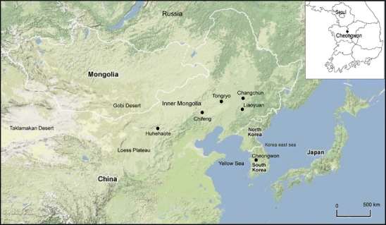
Map of the East Asian region and the Korean Peninsula, which are represented with the deserts, loess regions, and cities
Results
PM10 and PM2.5 levels
Figure 2 shows the variations in the daily maximum and mean concentrations of PM10 and PM2.5, as measured at Cheongwon between January and December 2005. The mean concentration was 47 ± 27 μg m−3 for PM10 and 27 ± 16 μg m−3 for PM2.5. The day-to-day variations of the daily mean concentrations were comparatively low in August, September, and the middle of October but high in the remaining months. Variations in the daily maximum concentrations were high except in August and September.
Fig. 2.
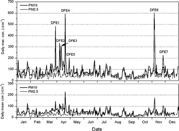
Variations of daily maximum and mean concentrations of PM10 and PM2.5 observed at Cheongwon from January to December 2005. The dustfall episodes (DFE) are considered as the PM10 concentration exceeded 190 μg m−3 for at least 2 h by sandstorms flowing into the Korean Peninsula
The daily variations in the PM10 and PM2.5 concentrations at Cheongwon were observed to be affected by the movement of large-scale air pollution masses in the East Asian region (Chung and Kim 2008; Kim and Chung 2008). Sandstorms that occur in NW China and Mongolia cause airborne dustfalls in Korea and Japan due to westerly winds. Accordingly, Fig. 2 shows a sudden rise in the PM10 concentration when the dust clouds cause airborne dustfall episodes (DFE) at Cheongwon.
Composite images from the NOAA satellite AVHRR data were used to observe the occurrence and movement of sandstorms. A dustfall was considered to be a dustfall episode if the PM10 concentration exceeded 190 μg m−3 for at least 2 h as a result of dust clouds caused by sandstorms flowing into the Korean Peninsula (Chung et al. 2003a). In 2005, there were seven dustfall episodes at Cheongwon, lasting a total of 11 days (Table 1). The maximum PM10 concentration was 500 μg m−3 or more in two of the episodes (on 20 April and 6 November), 300 μg m−3 or more in three of the episodes (on 29 March, 7 April, and 10 April), and 190 μg m−3 or more in the other two episodes (on 29 April and 26 November).
Table 1.
The maximum concentrations of PM10 and PM2.5, and mass ratio (in %) PM2.5/PM10 for DFE as observed at Cheongwon, Korea, from January to December 2005
| Case | Date | PM10 | PM2.5 | %-ratio | VSBY |
|---|---|---|---|---|---|
| DFE1 | 29 March | 481 | 32 | 6.7 | 10.2 |
| DFE2 | 7–8 April | 332 | 91 | 27.4 | 4.5 |
| DFE3 | 10–11 April | 305 | 34 | 11.1 | 10.5 |
| DFE4 | 20–21 April | 591 | 62 | 10.5 | 9.5 |
| DFE5 | 29 April | 203 | 75 | 37.0 | 10.2 |
| DFE6 | 6–7 November | 604 | 98 | 16.2 | 5.6 |
| DFE7 | 26 November | 225 | 123 | 54.7 | 1.6 |
| Mean (7 episodes, 11 days) | 392 | 74 | 18.9 | 7.4 | |
The average ratio of maximum PM2.5 and PM10 concentrations was 18.9% in the airborne dustfall episodes. However, the ratio of the maximum PM2.5 and PM10 concentrations was 64.5% in the absence of any airborne dustfall episodes (Fig. 2). In summer, the loess turns more or less damp with the growth of grass, and the winds decrease; hence, there is a drastic reduction in the occurrence of sandstorms and a virtual absence of airborne dustfall episodes in Korea. An analysis of NOAA satellite composite image indicates that four episodes out of seven sandstorms and associated dustfall episodes observed at Cheongwon. Four episodes show features differing in the ratio of concentrations of PM2.5/PM10 from each other, depending on the transport route.
Episode of 29 March 2005
Figure 3a shows a NOAA satellite image taken at 1447 Korean local standard time (LST) on 28 March 2005. A sandstorm occurred that day in a desert between Tongryo and Chifeng in the western part of Inner Mongolia. A cold front passed through the desert with a strong tail wind. The sandstorm headed toward the Korean Peninsula by means of the prevailing north wind (Fig. 3b). The surface meteorological charts indicate airborne dustfalls at an observation post south of Manchuria at 1800 LST on 28 March 2005. Moreover, this airborne dustfall was observed at Liaoyuan, which is south of Changchun, China and north Korea at 0300 LST on 29 March 2005.
Fig. 3.
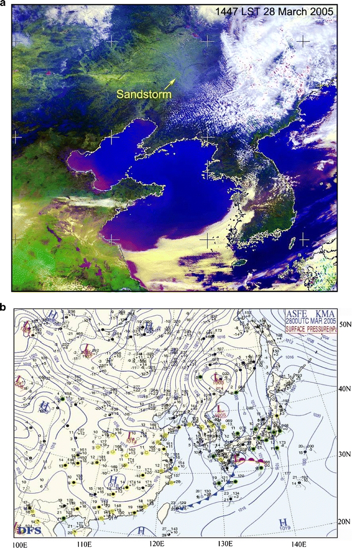
a A NOAA satellite image (1447 LST on 28 March 2005) showing a large-scale sandstorm occurrence over the eastern area of Inner Mongolia and b a surface meteorological chart at 0900 LST 28 March 2005
Figure 4a shows a surface meteorological chart for 0900 LST on 29 March 2005. It confirms that the strong N-NW wind across the Korean Peninsula was caused by the strong pressure gradient created by the high to the west and the low to the east. The arrival of the airborne dust cloud at Cheongwon caused the relative humidity to plunge from 72% to 33%, rapidly turning the weather dry. On 29 March 2005, an airborne dustfall episode with the dry air was observed across South Korea.
Fig. 4.
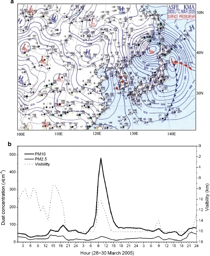
a A surface meteorological chart (0900 LST on 29 March) and b variations of hourly PM10, PM2.5, and visibility observed at Cheongwon for 28–30 March 2005
Figure 4b shows the hourly variations in visibility and in the PM10 and PM2.5 concentrations as observed at Cheongwon between 28 and 30 March 2005. The visibility and the concentrations of dust vary in inverse proportion to each other: thus, the minimum visibility of 10.2 km occurred when the dust concentration was at its maximum. However, the visibility stood low due to a high relative humidity. On 29 March 2005, the daily maximum levels of the PM10 and PM2.5 concentrations were observed at 1000 LST. During the peak there is a clear difference in the mass concentration between PM10 and PM2.5. About 6.7% of the PM10 mass consists of PM2.5. For 5 h during the dustfall episode, the PM10 concentrations ranged from 240 to 481 μg m−3, whereas the PM2.5 concentration was as low as 21 to 32 μg m−3. These results indicate that the PM2.5 concentration reached its minimum level during the airborne dustfall episode. Hence, the particles in the dustfall are predominantly PM3.0 particles or higher, with the majority being upward of PM10.
Episodes of 7 and 8 April 2005
Figure 5 presents NOAA satellite images and the surface meteorological charts for 5 to 7 April 2005. A cold front of low pressure passed through eastern Mongolia, causing a sandstorm on 5 April. The sandstorm headed in an east–southeasterly direction and passed through Inner Mongolia at 1443 LST on 6 April.
Fig. 5.
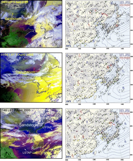
NOAA satellite images showing sandstorm transport, large-scale transport of air pollution (LSTAP) and surface meteorological charts (1500 LST on 6 April, 0600 LST on 7 April, and 1200 LST on 7 April) over East Asia for 6–7 April 2005
On 7 April, a cold front and the center of low pressure in the north-eastern part of the Korean Peninsula stretched out in a south-westerly direction. A dust cloud was seen to be drifting at 0734 LST along the rear of the cold front. The dust cloud stretched across the Korean Peninsula from the north-eastern part of the Korea east sea as the cold front headed toward the Korea east sea at 1148 LST on 7 April, though the dust cloud was barely discernible on the satellite image. A new sandstorm occurred with a strong wind in the eastern part of Inner Mongolia. In this case, the anthropogenic air pollution, originated from the Shantung Peninsula, China, spread across the Yellow Sea to the Korean Peninsula and the Korea east sea.
Figure 6 shows the hourly variations in visibility and the PM10 and PM2.5 concentrations observed at Cheongwon between 7 and 8 April 2005. The concentrations of PM10 and PM2.5 increased by 2000 LST on 7 April before the airborne dust cloud flowed in and the visibility decreased. The concentration of PM2.5 increased to as high as 80 to 91 μg m−3 on the afternoon of 7 April, a day affected by large-scale air pollution from China. Furthermore, an airborne dustfall episode occurred as a result of NW air flows after 2100 LST on the same day. The PM10 concentration began to rise whereas the PM2.5 concentration began to fall. The PM10 concentration sharply rose to as high as 332 μg m−3 at 2200 LST, whereas the PM2.5 concentration fell to approximately 16.0% of the PM10 concentration. The visibility improved as the PM2.5 concentration fell, and the relationship between visibility and PM2.5 (R = −0.7) was relatively higher than that between visibility and PM10 (R = −0.5).
Fig. 6.
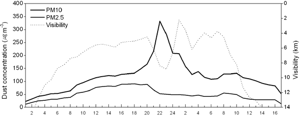
Variations of hourly PM10, PM2.5, and visibility observed at Cheongwon for 7–8 April 2005
Episodes of 6 and 7 November 2005
Figure 7 shows NOAA satellite images of a sandstorm that occurred in the Gobi Desert and headed to the Korean Peninsula on 5 and 6 November 2005. At 0900 LST on 5 November, a strong sandstorm was caused in the Gobi Desert in southern Mongolia by an intense high pressure system and a strong north-west wind at the rear of the cold front (not shown). The dust clouds that formed in the Gobi Desert, Mongolia, reached eastern Mongolia and eastern Inner Mongolia at 1500 LST on 5 November as a result of winds at 25 to 30 m s−1 at an altitude of 1,500 to 3,000 m. The dust clouds passed through the Bohai Bay and reached the Yellow Sea and north Korea at 0900 LST on 6 November.
Fig. 7.
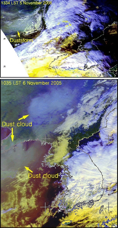
NOAA satellite images showing sandstorm occurrence in the Gobi Desert and associated dust cloud over the Yellow Sea region for 5–6 November 2005
Figure 8 shows the visibility and the hourly variations in the dust concentrations of PM10 and PM2.5 as observed at Cheongwon between 6 and 7 November 2005. There were two maximum values (bimodal): the first maximum PM10 concentration was 604 μg m−3; the second, measured 6 h later, was 485 μg m−3.
Fig. 8.
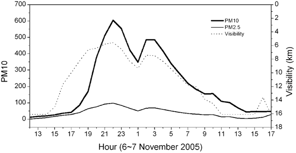
Variations of hourly PM10, PM2.5, and visibility measured at Cheongwon for 6–7 November 2005
The ratio of the maximum PM2.5 and PM10 values was 16.2%; furthermore, the PM2.5 value was excessively small. The visibility and the concentrations of PM10 and PM2.5 varied in inverse proportion to each other during the airborne dustfall episode. The PM10 concentration of the airborne dustfall episode was 190 μg m−3 or more for 12 h. During the airborne dustfall episode, the concentrations of O3, NO2, and SO2 maintained very low background values.
Episode of 26 November 2005
Figure 9 shows a NOAA satellite image taken at 1321 LST and a surface meteorological chart for 1200 LST on 25 November 2005. The high pressure over northern China affected the Yellow Sea and the Korean Peninsula, with industrial air pollutants distributed extensively over the Yellow Sea region. The Gobi Desert of Mongolia was in the periphery of a high pressure system in central China and, when a sandstorm occurred, it headed southeast along the periphery of the high pressure system. Thus, another airborne dustfall episode carrying with industrial air pollution from China occurred in the Korean Peninsula on 25 November 2005.
Fig. 9.
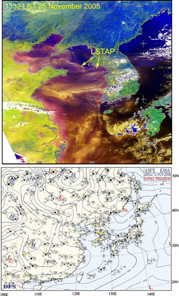
A NOAA satellite image showing a large-scale transport of air pollution (LSTAP) over the Yellow Sea and a meteorological chart at 1200 LST on 25 November 2007
Figure 10 shows the visibility and the hourly variations in the dust concentrations of PM10 and PM2.5 as observed at Cheongwon between 25 and 26 November 2005. The PM10 and PM2.5 concentrations rose gradually under the influence of large-scale air pollution that moved in from eastern China on 25 November. Relative humidity stood at approximately 100% during the first 10 h of November 25, showing the visibility to be close to 0.
Fig. 10.
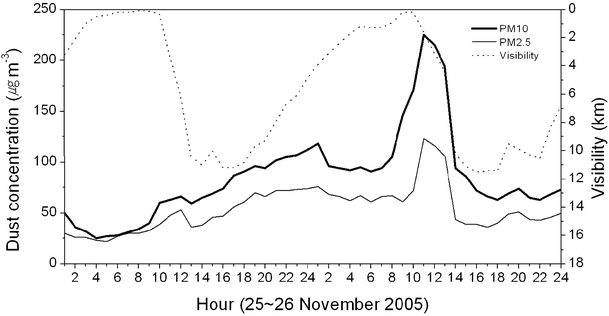
Variations of PM10, PM2.5, and visibility measured at Cheongwon for 25–26 November 2005
The dust concentration rose rapidly and the visibility fell during an airborne dustfall episode on 26 November. The ratio of the maximum PM2.5 and PM10 levels was 54.7%, and PM2.5 particles made up the bulk of the episode. As a result of the combination of anthropogenic air pollutants and the airborne dustfall, the ratio of the concentrations of PM2.5 and PM10 was substantially higher than in other episodes.
Discussion
Sandstorms can occur in the deserts of Mongolia and NNW China during any season of the year under certain meteorological conditions. Intense sandstorms, however, generally occur when strong winds are flowing over the ground between March and May, a period when winter has ended and ice has begun to thaw. The occurrence of sandstorms depends to a large degree on the dryness of the ground and on the depth of the snow that accumulated during the winter. Other factors include the movements of intense continental high pressure systems and strong convergent air currents at the rear of low pressure systems. Sandstorms seldom occur in summer because the desert and dry areas become rather damp, the grass grows, and the strong winds normally abate. The following summer sandstorms had no effect on the Yellow Sea or the Korean Peninsula because of prevailing southeast winds or the abatement of west winds: 12 June 2005 (southern Mongolia), 12 June 2005 (Inner Mongolia), 18 June 2005 (the Gobi Desert), 21 June 2005 (the Gobi Desert), 22 June 2005 (the Gobi Desert), and 17 July 2005 (south of the Gobi Desert).
Dust particles from the desert generally stay airborne for 100 days or more throughout the year. They are discernable, with equipment, in a place in the leeward direction from their origin when the particles reach 30 μg m−3. This study defines a dustfall episode as a dustfall in which the PM10 value exceeds, or equal to, 190 μg m−3 (Chung et al. 2003a). An analysis of the PM10 concentrations in airborne dustfall episodes as observed at Cheongwon between 1997 and 2004 indicates that airborne dustfalls occur on average about nine times a year and last for a total of 15 days. In 2005, a total of seven airborne dustfall episodes occurred over a period of 11 days, which is below average for 15 days between 1997 and 2004. While the PM10 concentration rises rapidly in an airborne dustfall episode, the PM2.5 concentration shows a relatively low ratio of composition. There is a sharp contrast between the rise of the PM2.5 concentration in large-scale air pollution from industrialized eastern China and the ratio of composition of PM2.5 and PM10.
Four instances have been observed where the dust and sand from dry areas in the desert remained airborne even when the PM10 concentration was less than 190 μg m−3 (Table 2). We include three instances in April 2005 where the PM10 concentration was high and the PM2.5 concentration was relatively low and they were too insignificant to be included as an airborne dustfall episode. The instance on 1 December showed a PM2.5 and PM10 concentration ratio of 45.4%, apparently as a result of the mixture of industrial air pollutants including sand, sulfate, nitrate, and so on.
Table 2.
Dust and sand from dry areas in the desert remained airborne even when the PM10 concentration was less than 190 μg m−3 as observed at Cheongwon, Korea from January to December 2005
| Date | PM10 (μg m−3) | PM2.5 (μg m−3) | %-ratio | VSBY (km) |
|---|---|---|---|---|
| 12 April | 160 | 30 | 18.8 | 11.9 |
| 15 April | 176 | 39 | 22.2 | 13.0 |
| 22 April | 144 | 20 | 13.9 | 16.0 |
| 1 December | 130 | 59 | 45.4 | 9.5 |
Conclusion
An analysis in 2005 of the concentrations of air pollutants and meteorological elements as observed at Cheongwon in central Korea indicates that there were seven airborne dustfall episodes that lasted for a total of 11 days. Sandstorms and associated airborne dustfall episodes were as few as seven occurrences in 2005, because of the large accumulation of snow at the origin of the sandstorms during winter and mild fluctuations in high and low pressure systems. In summer, the dustfalls did not reach the Korean Peninsula due to the absence of strong west wind airflows.
When sandstorms headed directly to the Korean Peninsula without passing through large metropolitan cities and industrial areas in China, the PM2.5 concentrations were relatively low, with an average PM2.5/PM10 ratio of 20% or lower. When atmospheric pollution covering an extensive area of eastern China mixed with airborne dustfalls of the natural origin, the PM2.5/PM10 ratio was 25% or higher. Observation and analysis of more than five instances (not shown) confirm that sand dust from China fell short of the standard level (190 μg m−3) for an airborne dustfall episode.
Acknowledgement
Research fund is provided by Cater (2006–3103).
Open Access
This article is distributed under the terms of the Creative Commons Attribution Noncommercial License which permits any noncommercial use, distribution, and reproduction in any medium, provided the original author(s) and source are credited.
References
- Chon J. Historical records of yellow sand observations in China. Research of Environmental Science. 1994;7(6):1–11. [Google Scholar]
- Chung YS. Air pollution detection by satellite: the transport and deposition of air pollutants over oceans. Atmos Environ. 1986;20:617–630. doi: 10.1016/0004-6981(86)90177-0. [DOI] [Google Scholar]
- Chung YS. On the observations of yellow sand in Korea. Atmos Environ. 1992;26A:2743–2749. [Google Scholar]
- Chung YS, Le HV. Detection of forest-fire smoke plumes by satellite image. Atmos Environ. 1984;18:2143–2151. doi: 10.1016/0004-6981(84)90201-4. [DOI] [Google Scholar]
- Chung YS, Yoon MB. On the occurrence of yellow sand and atmospheric loadings. Atmos Environ. 1996;30:2387–2397. doi: 10.1016/1352-2310(96)00015-5. [DOI] [Google Scholar]
- Chung YS, Kim HS. Observations of massive-air pollution transport and associated air quality in the Yellow Sea region. International Journal of Air Quality, Atmosphere and Health. 2008;1:69–70. doi: 10.1007/s11869-008-0014-y. [DOI] [Google Scholar]
- Chung YS, Kim HS, Jugder D, Natsagdorj L, Chen SJ. On sand and duststorms and associated significant dustfall observed in Chongju-Cheongwon, Korea during 1997–2000. Water, Air and Soil Pollution: Focus. 2003;3:5–19. doi: 10.1023/A:1023242000367. [DOI] [Google Scholar]
- Chung YS, Kim HS, Park KH, Jhun JG, Chen SJ. Atmospheric loadings, concentrations and visibility associated with sandstorms: satellite and meteorological analysis. Water Air Soil Pollut. Focus. 2003;3:21–40. doi: 10.1023/A:1023261717206. [DOI] [Google Scholar]
- Chung YS, Kim HS, Dulam J, Harris J. On heavy dustfall observed with explosive sandstorms in Cheongwon-Chongju, Korea in 2002. Atmos Environ. 2003;37:3425–3433. doi: 10.1016/S1352-2310(03)00360-1. [DOI] [Google Scholar]
- Huebert B, Bates T, Russell P, Seinfeld J, Wang M, Uematsu M, Kim YJ. An overview of ACE-Asia: strategies for quantifying the relationships between Asian aerosols and their climatic impacts. J Geophys Res. 2003;108:8633. doi: 10.1029/2003JD003550. [DOI] [Google Scholar]
- Jacob DJ, Crawford JH, Kleb MM, Connors VS, Bendura RJ, Raper JL, Sachse GW, Gille JC, Emmons L, Heald CL. The Transport and Chemical Evolution over the Pacific (TRACE-P) aircraft mission: design, execution, and first results. J Geophys Res. 2003;108:9000. doi: 10.1029/2002JD003276. [DOI] [Google Scholar]
- Kim J. Transport routes and source regions of Asian dust observed in Korea during the past 40 years (1965–2004) Atmos Environ. 2008;42:4778–4789. doi: 10.1016/j.atmosenv.2008.01.040. [DOI] [Google Scholar]
- Kim HS, Chung YS. Satellite and ground observations for large-scale air pollution transport in the Yellow Sea Region. J Atmos Chem. 2008 [Google Scholar]
- Kim YK, Song SK, Lee HW, Kim CH, Oh IB. Characteristics of Asian dust transport based on synoptic meteorological analysis over Korea. Journal of Air & Waste Management Association. 2006;56:306–316. doi: 10.1080/10473289.2006.10464724. [DOI] [PubMed] [Google Scholar]
- Kurosaki Y, Mikami M (2003) Recent frequent dust events and their relation to surface wind in East Asia. Geophys Res Lett 30. doi:10.1029/2003GL017261
- Mckendry IG, Hacker JP, Stull R. Long-range transport of Asian dust to the Hawaiian Islands. Science. 2001;220:198–197. [Google Scholar]
- Wang W, Fang ZY. Numerical simulation and synoptic analysis of dust emission and transport in East Asia. Glob Planet Change. 2006;52:57–70. doi: 10.1016/j.gloplacha.2006.02.004. [DOI] [Google Scholar]


