Abstract
World wind power resources are abundant, but their utilization could be limited because wind fluctuates rather than providing steady power. We hypothesize that wind power output could be stabilized if wind generators were located in a meteorologically designed configuration and electrically connected. Based on 5 yr of wind data from 11 meteorological stations, distributed over a 2,500 km extent along the U.S. East Coast, power output for each hour at each site is calculated. Each individual wind power generation site exhibits the expected power ups and downs. But when we simulate a power line connecting them, called here the Atlantic Transmission Grid, the output from the entire set of generators rarely reaches either low or full power, and power changes slowly. Notably, during the 5-yr study period, the amount of power shifted up and down but never stopped. This finding is explained by examining in detail the high and low output periods, using reanalysis data to show the weather phenomena responsible for steady production and for the occasional periods of low power. We conclude with suggested institutions appropriate to create and manage the power system analyzed here.
Keywords: meteorology, transmission, wind integration, wind power, meteorologically designed transmission
The world’s wind resource for electric power is larger than the total energy need of humanity. For surface winds over land globally, Archer and Jacobson (1) estimate the wind resource at 72 terawatt (TW), nearly five times the 13 TW world’s demand for all energy. In a more detailed regional estimate, Kempton et al. (2) calculated that two-thirds of the offshore wind power off the U.S. Northeast is sufficient to provide all electricity, all light-vehicle transportation fuel, and all building heat for the adjacent states from Massachusetts to North Carolina.*
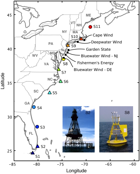
Planning of wind development in the U.S. Atlantic region is already underway. Fig. 1 shows as black squares offshore wind developments that have already been approved by their adjacent state governments. Each square represents a planned array of 80–150 turbines, with each array having a capacity of 280–425 megawatts (MW). Together these represent a power capacity of about 1,700 MW (the scale of a large coal or nuclear power plant), yet together they tap only 0.1% of the region’s offshore wind resource (2). Each will be connected independently to the electric grid by a submerged power transmission cable running ashore to the closest transmission. Electric system planning for each has proceeded separately, to meet the power needs of each adjacent state. Here we analyze the spatial and meteorological aspects of distributed offshore generation, then conclude by proposing a more coordinated regulatory approach better matched to this power resource.
Fig. 1.
Proposed offshore wind projects off the U.S. coast (black squares and names). NDBC offshore meteorological stations selected for this study, running from Florida (S1) to Maine (S11) with color bullets for buoys and color triangles for towers. Inset photos: discus buoy (S8), with anemometer height of zref = 5 m, and a lighthouse tower (S2) at zref = 44 m.
Leveling Wind Fluctuations. The variability of wind power is not as problematic as is often supposed, since the electric power system is set up to adjust to fluctuating loads and unexpected failures of generation or transmission. However, as wind power becomes a higher proportion of all generation, it will become more difficult for electric system operators to effectively integrate additional fluctuating power output. Thus, solutions that reduce power fluctuations are important if wind is to displace significant amounts of carbon-emitting energy sources.
There are four near-term ways to level wind power and other fluctuating generation sources. (i) Expand the use of existing control mechanisms already set up to handle fluctuating load and unexpected equipment outages—mechanisms such as reserve generators, redundant power line routes, and ancillary service markets. This is how wind is integrated today (5). (ii) Build energy storage, as part of the wind facility or in another central location. (iii) Make use of distributed storage in loads, for example home heaters with thermal mass added or plug-in cars that can charge when the wind blows or even discharge to the grid during wind lulls (6). (iv) Combine remote wind farms via electrical transmission, the subject of this article.
Prior Studies of Wind Leveling via Transmission. Several studies in the western United States and Europe have investigated the power leveling of aggregating geographically distributed wind farms (7–10). They find improvement in the steadiness of the available power, even when the stations are relatively close (11, 12) and a decrease in the number of low- or no-wind events (13, 14). Additional stations decrease the variability of the summed wind power (8). Reduced variability means fewer very low power times, as well as fewer times of the highest power (14).
Interconnecting wind generators generally yields greater benefit for longer separation distances. There is less benefit from proximate stations, as they are more likely to experience similar weather at the same time, due to local forcing conditions such as changes in topography or surface high- and low-pressure systems.
Greater distances between wind stations usually lead to longer periods of smoothing (15, 16). For example, local geographic dispersion in Germany has been shown to smooth on short timescales (∼5 min) at station distances of 2 km. Some studies (8, 10, 13) suggest there will be a distance, roughly 800–1,000 km, beyond which adding a station no longer brings additional improvement.
For example, Oswald et al. (10) analyzed eight stations distributed throughout Britain during 12 Januaries, a month of peak power demands, peak wind speeds, and peak variability. They also compared Britain with data from Ireland, Germany, and Spain. Observing large power swings in a 12-hour period, Oswald et al suggested that distributed generation would not help much since most of the region experienced the same wind conditions. But, one might ask whether their grid orientation and size were sufficient for this conclusion. The synoptic pressure patterns of Europe (17) and the United States (18) are larger than the extent of Britain as a grid studied by Oswald et al (10).
Perhaps these studies were not of sufficient extent or meteorological diversity—this is an important question for the analysis in this article. For example, during the warm season synoptic high-pressure areas with light and variable winds can extend over ∼1,000 km, thus we hypothesize that a distributed grid must be > 1,000 km in order to achieve nearly continuous power. Our second hypothesis is that the orientation of the grid is important in order to maximize the diversity in the regional meteorology. For example, since many U.S. East Coast cyclones frequently track along the coast from southwest to northeast, we will here test whether a transmission grid along the coast achieves more smoothing than other orientations in this region.
Some studies propose methods for selecting among stations to make an optimum aggregate (7, 19, 20). Here we address the more fundamental question of variability and combination of stations at the synoptic scale and leave optimization of station selection for subsequent analysis. [We use the term “synoptic” to refer to wind fluctuations that are due to the passage of large-scale (∼1,000 km) high- and low-pressure systems.]
Meteorological Choice of Region. Our approach is distinct from prior work in that we examine a region larger than the synoptic scale (Fig. 1), not subject to uniform meteorological conditions (Fig. S1), and more aligned along the prevailing movement of high- and low-pressure systems rather than perpendicular to it. All the stations in our study area (Table S1) are over the ocean, which has stronger and more constant winds than land (21–23). An additional practical reason for the choice of this continental shelf to study is that it is adjacent to one of the most carbon-intensive urban concentrations in the world, yet these populations comprise a single national entity, simplifying the administrative possibilities for planning transmission interconnection and coordinated development. The methods for computing power output from wind speed are found in Materials and Methods below. Since the wind speed data we use are typically reported with 1 h resolution, we cannot evaluate the effect of smoothing and the continuity of supply over much shorter time intervals.
Results
We first analyze the seasonal patterns of wind energy and the correlation of power from different stations distributed along the coast. Next we explore the effects that offshore transmission could have upon aggregate power produced by the entire array.
Calculating Power Generation and Capacity Factor.
Summary averages over the entire 5-yr study period are shown in SI Text, Table S2, specifically, the average wind speed, the average power output for an example 5 MW turbine (Fig. S2), and the “capacity factor,” or CF. The capacity factor is a standard measure for wind power analysis. It is a dimensionless quantity defined as energy output per year (in MWh) divided by the number of hours in the year times the nameplate, or rated, capacity (in MW). In simpler terms, CF is the average output (in MWa) over the rated capacity (in MW) (14, 22). For example, if a 5 MW turbine produces an average of 2 MWa throughout a year, its CF in that location is 0.40. These methods are described in prior publications (20) and in SI Text.
Some of our figures below will use stations S2 and S10 as distinct illustrative examples. Station S2 is the second lowest in CF and average power output, whereas S10 is the second highest. They coincidentally are also each one away from the ends of the extent, thus experiencing different weather. Thus we use stations S2 and S10 in some subsequent figures as examples of diverse individual sites. For summary and quantitative measures, we continue to use all 11 stations.
Correlation of Wind Power Output with Distance.
Previous studies have shown that wind speed correlation between stations drops off with distance (7, 10, 13). Here we compute the Pearson correlation in electric power output among stations.
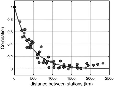
In Fig. 2, each dot is a pair of stations, with each pair plotted by distance between them and correlation between their wind speeds. The highest correlations, r > 0.6, occur for stations less than 350 km apart (the dot at 0 distance and 1.0 correlation represents all 11 stations, each correlated with itself). For stations more than ∼750 km apart, correlations are below 0.2, and more than 1,300 km, correlations are below 0.1. This confirms our first hypothesis, that correlation drops at the synoptic scale.
Fig. 2.
Correlation R between pairs of stations, by distance. The gray curve represents an exponential fit R = exp(-x/D) for the optimum value of D = 430 km.
For mitigating wind power fluctuations, the ideal would be to combine stations with negative correlation coefficients, as suggested by Kahn (7). For negatively correlated pairs, when one is high, the other is likely to be low, yielding more steady combined power. We find only one negative correlation within the hourly data (S4 with S10), and that one is of such small magnitude (-0.001) as to be effectively zero. [Sinden’s UK study similarly found only one negative correlation, between stations at 900 km separation (13).] Therefore, near-zero correlation may be a more realistic goal than negative correlation for pairing of stations.
The above results suggest that the intermittency of wind power generation might be smoothed and leveled by combining the output of different geographical stations at distances more than 750–1,300 km. Next we test this hypothesis.
An Offshore Grid to Level Power Generation.
The power from offshore wind generators can be interconnected by submerged high-voltage transmission cable. For such long distances (S1 to S11 would be ∼2,500 km), undersea high-voltage direct current (HVDC) cables are well-suited. Example prior uses include the 500 kV, 3,000 MW Neptune cable connecting New Jersey to Long Island (24) and NorNed, Connecting Norway to the Netherlands, the longest submarine power cable to date at 580 km. In the European Union, undersea cables connecting offshore wind farms and multiple countries are under discussion (called the “Super Grid”), but we find no published meteorological analysis of the smoothing effects. We refer to our hypothesized long-distance transmission cable here as the “Atlantic Transmission Grid” and the power output from it as Pgrid.
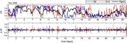
As a graphical illustration of how such interconnection affects wind power fluctuations, Fig. 3 shows an example month, November 1999, and just two of the individual stations to simplify this figure. The top half of Fig. 3 shows power output from individual stations S2 and S10 (thin colored lines), compared with power output from the entire grid of all 11 stations, Pgrid, the thick black line. The two individual stations exhibit frequent changes in power output, even from zero to full power, or vice versa, in a few hours. The bottom half of Fig. 3 shows the change in power output, with each vertical line representing 1 h. For example, a line up to 0.5 means that the output increased by 50% of capacity within 1 h. For individual stations S2 and S10, about 20 times in this month the output changed by over 50% in 1 h. By contrast, the entire grid, the black line, changes by no more than 10% of its capacity in any 1 h.
Fig. 3.
(Top) One month of power, expressed as CF, from two isolated wind parks (blue and orange lines) compared with power from the Atlantic Transmission Grid (Pgrid, thick black line). (Bottom) Hourly changes in CF, comparing individual wind parks (blue and orange) with the Grid (black line).
Fig. 3 shows that in this example month, the Grid would have improved the generation of electricity by offshore winds in two distinct ways. First, output fluctuates more slowly. The importance to the power sector of slower output fluctuations is that other generators or transmission can be ramped up or down with plenty of lead time. This makes the power from the wind aggregate more valuable and easier to manage than the power from wind at a single location. The second improvement is that the Grid produces midlevel power more often than extremes, an effect also noted in prior studies.
Fig. 3 illustrates these important principles but covers only one month. In the next section we extend this analysis to a 5-yr period, using aggregate statistics.
Power from the Atlantic Transmission Grid: Statistics Over Five Years.
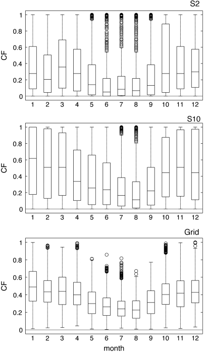
We statistically summarize the effects of transmission interconnection via boxplots and histograms, each based on 5 yr of data. Fig. 4 shows the boxplot distributions of CF for two sample stations (S2 and S10) and for the entire grid. Looking across the 12 months, Fig. 4 illustrates that S2 and S10 differ in monthly output, although both show lower power in the warmer months (May through September). The main point of Fig. 4 is that the bottommost plot, the entire grid, shows a much smaller interquartile range, indicating that the grid’s power output frequently falls near the median.
Fig. 4.
Capacity factor monthly variability for individual wind parks at S2, S10, and for Pgrid, shown as boxplots. The central mark in each box is the median; box edges are the 25th and 75th percentiles. The whiskers extend to the most extreme data-points not considered outliers (approximately ± 2.7σ and 99.3% coverage if data is normally distributed). Outliers are plotted as circles.
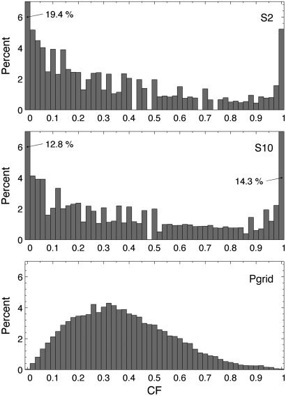
In Fig. 5, the distribution of output is shown with three histograms of all hours for all 5 yr. The top two histograms show power output from two sample sites, S2 and S10; the bottommost shows output from the entire Grid. The individual sites are choppy, each with an extreme modal value (0 or 1). The Grid has a modal output value about equal to the average CF, that is, power output is most often in the range of midvalues. This is illustrated and discussed further in Fig. S3, using a probability distribution function like that used in some prior studies (2, 14).
Fig. 5.
CF histograms for individual locations S2, S10, and Pgrid.
We quantitatively examined the power from the Atlantic Transmission Grid year-by-year over the entire 5 yr, 1998 to 2002 (shown in Fig. S4). During each of years one through five, CF was below 0.05 for the following percentages of hours: 2.7%, 0.6%, 1.3%, 0.7%, 0.3%, or for the entire period, overall, under 0.05 CF an average of 1.1%.
During the entire 5-yr time studied, Grid power never drops to zero, that is, power output is uninterrupted. Although a zero-output hour may be found if more years are examined, 5 yr of interrupted power has not been seen in the prior wind transmission analysis reviewed above, nor for that matter is it seen in individual fossil power plants, which average a 5.6% forced outage rate (5). In the next section we will analyze the meteorology and the dynamical reasons for good and the poor periods.
Examination of Weather Patterns.
To explore the synoptic variability of winds along the eastern seaboard, the daily North American Regional Reanalysis (25) was used, which provides long-term winds and pressures for the North American domain at 32-km grid spacing.
We analyze sea level pressure and surface winds to track the evolution of synoptic systems over the area and to understand their impact on power generation. We select two months, covering relatively low wind (May) and high wind (November) conditions, and a third month to exemplify an unusual period of prolonged very low energy generation (June 1998). All are picked also because they have no gaps in the National Data Buoy Center data (NDBC) time series, so with each we can compare a month’s generation of power across all stations.
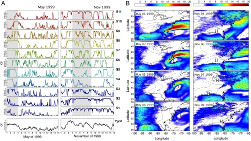
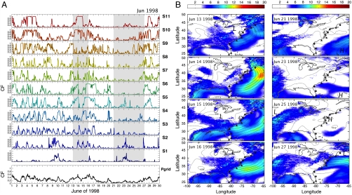
In order to understand these patterns of variability, we now turn to the daily reanalysis data. We pick four illustrative meteorological events, two on Fig. 6 and two on Fig. 7. In 6A and 7A, each event is shown by a gray band over the power curves. In 6B and 7B, each event is expanded, using NARR data, to show high and low pressure with H and L, the sea level pressure with lines for hPa, and 10-m wind speeds with color for m s-1, as shown in the scale.
Fig. 6.
(A) Capacity factors for 11 stations in May 1999 and November 1999; line colors match station colors in Fig 1. The lowest graph, Pgrid, is the aggregate CF if all stations are connected by transmission. The two gray date ranges are each expanded to 4 d on the maps (B). (B) Sea level pressure (lines, in hPa) and wind speed (color scale at top, in m s-1) for the events from May 1–4 (Left) and November 4–9 (Right), 1999.
Fig. 7.
(A) Capacity factors in June 1998 for 11 stations and for the Grid (Lowermost). The two gray date ranges are expanded to the right. (B) Sea level pressure (lines, in hPa) and wind speed (color scale, m s-1) for the event of June 13–16 (Left) and June 21–27 (Right).
For the first gray dates in Fig. 6A, May 1–4, 1999, the NARR data in 6B show that an extratropical cyclone moved northward along the East Coast. Strong northeasterly winds (14–17 m s-1) were off the North Carolina coast on May 1, 1999. As the system moved northeastward on May 2–4, the entire set of northern stations (S5–S11) experienced winds of 8–12 m s-1. Turbine power during May 1–4 is seen in Fig. 6A. Stations S4–S6 are at full power on the first of May, a day when northern stations have very low production (compare CF of each station during this event). As the system moves northward, on May 3, S4 power falls quickly, followed by S5 and S6. Meanwhile, as the weather system enters the Gulf of Maine, stations S9, S10, and then S11 start producing energy around May 2, sustaining it for 2–3 d.
Fig. 6 also shows the synoptic situations for November 4–9, 1999. A large anticyclone remains relatively stationary over the East Coast from November 4–9 (Fig. 6B). The anticyclone over the southeast intensifies from 1027 to 1031 hPa between November 4–6, 1999. Subsequently, the high-pressure system weakens to 1025 hPa by November 9, 1999. During this period, higher winds are found on the northern and southern sides of this system, respectively, over coastal New England and Florida, where the largest surface pressure gradients are found. This generates relatively strong eastward winds for stations S10–S11 and westward winds for the southern stations S1–S3. Meanwhile, weaker winds are observed at the center of the high-pressure positioned over North Carolina. While moving eastward, this high-pressure still generates full rated power (CF = 1) for nearly a week for the northern (S8–S11) and southern (S1–S3) stations. This example also illustrates why it is important for the N-S Grid to extend a distance longer than the synoptic scale of the Bermuda High.
Two examples of less ideal power leveling are shown for June 1998 on Fig. 7. During June 13–16, a wide low-pressure system develops over the eastern United States (Fig. 7B). This is the result of a smaller cyclone over the northeast United States on June 13–14, and then another cyclone approaching from the Great Lakes that merges with this northeast low-pressure system on June 15. As a result, the stations to the north (S10–S11) and center of the grid (S4–S6) experience reasonable generation of power, others do not (Fig. 7A, first gray band of dates). Yet the grid output is fairly level except midday on June 15.
A worse situation for wind generation is June 21–27, 1998, when a broad area of weak high pressure (1018 hPa) develops over the mid-Atlantic by June 25 and remains steady above the region for nearly 4 d, June 25–27 (Fig. 7B). Because of the large dimensions and very weak pressure gradients of the high-pressure system, wind speeds are generally less than 5 m s-1 throughout the entire area.
To better understand the synoptic flow associated with low-power periods, we selected intervals of less than 0.05 CF and composited (averaged) those. The resulting composite pressure maps were too smooth to make any physical interpretation; that is, they did not show a clear pattern of a predominant type of synoptic situation when low winds occur throughout. After perusal of several of these low-power events, we infer that widespread low winds could be due to any of several causes: an extension of the Bermuda high, or a separate high moving to the north or south, or just a baggy low over the East Coast.
Overall, the daily weather data illustrate why the Atlantic Transmission Grid yields uninterrupted power output. There is almost always a pressure gradient somewhere, and cyclonic events move along the coast. There are a few times of low power throughout, but they are not due to any one particular weather pattern.
Relating our results to the prior studies reviewed earlier, one component of the power leveling is the motion of weather systems along the north–south orientation of the Atlantic Transmission Grid. From this perspective, we note that Simonsen and Stevens (8) found that the rate of decorrelation with distance was related to the orientation—their case, the Central Great Plains, shows quicker decreases in correlation in the east–west direction than in north–south, consistently with typical east–west passage of fronts in that region. Conversely, the lack of benefit seen by aggregating stations in the United Kingdom (10) may be due in part to the roughly north–south orientation of the island, thus experiencing their east–west passage of frontal systems nearly simultaneously.
From this regional meteorological perspective, a subsequent analysis could build on our approach of meteorologically chosen transmission but optimize site choice rather than taking evenly placed met stations as we have done. A deliberately optimized array of offshore generator locations should produce even more level output, and even fewer times of low power.
Discussion
In the study region, using our meteorologically designed scale and orientation, we find that transmission affects output by reducing variance, slowing the rate of change, and, during the study period, eliminating hours of zero production. The result is that electric power from wind would become easier to manage, higher in market value, and capable of becoming a higher fraction of electric generation (thus more CO2 displacement).
Is transmission an economically practical way to level wind? As an approximate cost comparison, a total of 2,500 MW of offshore wind generation has been approved or requested by states from Delaware to Massachusetts (all those shown in Fig. 1, plus the 700 MW New York request for proposals). Connecting them by a 3 gigawatt (GW) HVDC submarine cable would require 350 miles of cable. At early European offshore wind capital costs of $4,200/kW and submarine cable capital costs of $4,000,000/mile, the installed costs of planned offshore wind generation would be approximately $10.5 billion; the connecting transmission would add $1.4 billion (26). They are matched in capacity, each approximately 3 GW, yet the transmission adds less than 15% to the capital cost of generation. This is in line with the market cost of leveling wind via existing generation, currently estimated to add about 10% to the cost of energy (10% cost adder for wind penetrations up to 20%, then a higher percentage cost added at higher penetration of wind) (27).
Transmission is far more economically effective than utility-scale electric storage (e.g. pumped hydro), whose capital costs are approximately equal to generation. A thorough cost analysis is beyond the scope of this paper, but these approximate comparisons suggest that transmission costs are commensurate with the value of leveling.
Our findings have implications for the approach taken to wind development and choice of wind sites. Whereas today’s developers prospect for the windiest single site, we would advocate a broader analysis—to optimize grid power output by coordinated meteorological and load analysis of an entire region.
This approach to choosing and interconnecting sites has institutional implications. Today, generation of electricity is primarily a state matter, decided by state public utility commissions, whereas the Independent System Operators (ISOs) manage wholesale power markets and plan transmission. An ISO is the type of organization that might plan and operate the electric system we envision, probably with a mix of owners—private firms, existing electric utilities, and/or public power authorities. Because of the unique characteristics of building and operating offshore, and because our proposed Atlantic Transmission Grid would exist primarily in federal waters and bridge many jurisdictions on land, it may make sense to create a unique ISO, here dubbed the “Atlantic Independent System Operator.” Like existing ISOs, the Atlantic ISO would be responsible for managing and regulating the bulk power market along the offshore transmission cable, but with jurisdiction matched to the synoptic scale of the resource.
Whatever the institutions that ultimately manage this resource, we have shown that the nature of wind power generation is dramatically altered by scale and interconnection—and we have shown the value of a new way of planning transmission corridors, designing their alignment based on meteorological patterns at the synoptic scale.
Materials and Methods
To examine our hypotheses, we chose the Eastern Seaboard of the United States, a span of nearly 2,500 km in northeast–southwest direction. To study the effects of a large interconnected wind power array, we use anemometer data from dispersed stations (using NDBC data) and we model electrical output from the wind speed at each station (SI Text).
The colored symbols in Fig. 1 show the locations of NDBC measurements. We selected only times for which we had wind speed data from all 11 stations, thus only 59% of the hours during the 5 yr are included in our database. Then we extrapolated wind speed from measurement height to turbine height and converted from wind speed to power output using previously documented methods (23). More information on these methods is in SI Text.
Supplementary Material
Acknowledgments.
Delaware Sea Grant SG0707 R/CT-3, R.W. Garvine and W. Kempton (PIs) supported this project. F.M.P. was also supported by CAPES (BEX 224203-6). The article was improved by suggestions from PNAS reviewers.
Footnotes
The authors declare no conflict of interest.
This article is a PNAS Direct Submission.
This article contains supporting information online at www.pnas.org/cgi/content/full/0909075107/DCSupplemental.
References
- 1.Archer CL, Jacobson MZ. Evaluation of global wind power. J Geophys Res. 2005;110:D12110. 10.1029/2004JD005462. [Google Scholar]
- 2.Kempton W, Archer CL, Garvine RW, Dhanju A, Jacobson MZ. Large CO2 reductions via offshore wind power matched to inherent storage in energy end-uses. Geophys Res Lett. 2007;34:L02817. 10.1029/2006GL028016. [Google Scholar]
- 3.Roy SB, Pacala SW, Walko RL. Can large wind farms affect local meteorology? J Geophys Res. 2004;109:D19101. 10.1029/2004JD004763. [Google Scholar]
- 4.Keith DW, et al. The influence of large-scale wind power on global climate. Proc Natl Acad Sci USA. 2004;101(46):16115–16120. doi: 10.1073/pnas.0406930101. [DOI] [PMC free article] [PubMed] [Google Scholar]
- 5.North American Electric Reliability Council. Generating Unit Statistical Brochure, 2003–2007, October 2008. Princeton, NJ: NERC; 2008. [Google Scholar]
- 6.Kempton W, Tomić J. Vehicle to grid implementation: From stabilizing the grid to supporting large-scale renewable energy. J Power Sources. 2005;144(1):280–294. 10.1016/j.jpowsour.2004.12.022. [Google Scholar]
- 7.Kahn E. The reliability of distributed wind generators. Electr Pow Syst Res. 1979;2:1–14. [Google Scholar]
- 8.Simonsen TK, Stevens BG. Proc Global Wind Power. Chicago: American Wind Energy Association; 2004. Regional wind energy analysis for the Central United States; p. 16. [Google Scholar]
- 9.Czisch G, Ernst B. Windpower 2001. Washington, DC: American Wind Energy Association; 2001. High wind power penetration by the systematic use of smoothing effects within huge catchment areas shown in a European example. [Google Scholar]
- 10.Oswald J, Raine M, Ashraf-Ball H. Will British weather provide reliable electricity? Energ Policy. 2008;36:3202–3215. [Google Scholar]
- 11.Ernst B, Wan Y, Kirby B. Short-term power fluctuation of wind turbines: Looking at data from the German 250 MW measurement program from the ancillary services viewpoint; Windpower ’99 Proceedings; June 20–23, 1999; Burlington, Vermont; Washington, DC: American Wind Energy Association; 1999. [Google Scholar]
- 12.Milligan MR, Factor T. Optimizing the Geographic distribution of wind plants in Iowa for maximum economic benefit and reliability. Wind Eng. 2000;24(4):271–290. [Google Scholar]
- 13.Sinden G. Characteristics of the UK wind resource: Long-term patterns and relationship to electricity demand. Energ Policy. 2007;35(1):112–127. [Google Scholar]
- 14.Archer CL, Jacobson MZ. Supplying baseload power and reducing transmission requirements by interconnecting wind farms. J Appl Meteorol Clim. 2007;46:1701–1717. [Google Scholar]
- 15.Holttinen H, Hirvonen R. Power system requirements for wind power. In: Ackermann T, editor. Wind Powering Power Systems. New York: Wiley; 2005. pp. 143–167. [Google Scholar]
- 16.DeCarolis JF, Keith DW. The economics of large-scale wind power in a carbon constrained world. Energ Policy. 2006;34:395–410. [Google Scholar]
- 17.Giebel G. University of Oldenburg; On the benefits of distributed generation of wind energy in Europe; p. 104. PhD thesis. [Google Scholar]
- 18.Barry RM, Carleton A. Synoptic and Dynamic Climatology. New York and London: Routledge; 2001. p. 620. [Google Scholar]
- 19.Milligan MR, Artig R. Choosing wind power plant locations and sizes based on electric reliability measures using multiple year wind speed measurements. National Renewable Energy Laboratory. 1999. p. 9. NREL/CP-500-26724.
- 20.Cassola F, Burlando M, Antonelli M, Ratto CF. Optimization of the regional spatial distribution of wind power plants to minimize the variability of wind energy input into power supply systems. J Appl Meteorol Clim. 2008;47:3099–3116. [Google Scholar]
- 21.Barthelmie RJ, Courtney MS, Højstrup J, Larsen SE. Meteorological aspects of offshore wind energy: Observations from the Vindeby wind farm. J Wind Eng Ind Aerod. 1996;62:191–211. [Google Scholar]
- 22.Garvine RW, Kempton W. Assessing the wind field over the continental shelf as a resource for electric power. J Mar Res. 2008;66(6):751–773. [Google Scholar]
- 23.Pimenta F, Kempton W, Garvine R. Combining meteorological stations and satellite data to evaluate the offshore wind power resource of southeastern Brazil. Renew Energ. 2008;33:2375–2387. [Google Scholar]
- 24.Bahrman MP, Johnson BK. The ABCs of HVDC transmission technologies: An overview of high voltage direct current systems and applications. IEEE Power Energy M. 2007;March/April [Google Scholar]
- 25.Mesinger F, et al. North American Regional Reanalysis. Bull Amr Meteorol Soc. 2006;87:343–360. Data at: http://www.emc.ncep.noaa.gov/mmb/rreanl/ [Google Scholar]
- 26.Milborrow D. No consensus on offshore costs. Windpower Monthly. 2009;Sept:7–9. [Google Scholar]
- 27.Milligan MK, et al. Wind power myths debunked. IEEE Power Energy M. 2009;7(6):89–99. [Google Scholar]
Associated Data
This section collects any data citations, data availability statements, or supplementary materials included in this article.


