Abstract
The Leeward Kohala Field System (LKFS) covering ∼60 km2 on Hawai‘i Island is one of the world's best-studied archaeological examples of preindustrial agricultural intensification. Archaeological correlates for households over a 400-y period of intensification of the LKFS (A.D. 1400–1800) indicate that household age, number, and distribution closely match the expansion of agricultural features at both macro- and microscales. We excavated and dated residential complexes within portions of five traditional Hawaiian land units (ahupua‘a), two in the central core of the field system and three in the southern margins. Forty-eight radiocarbon dates from 43 residential features indicate an overall pattern of exponential increase in the numbers of households over time. Spatial distribution of these dates suggests that the core of the LKFS may have reached a population saturation point earlier than in the southern margins. Bayesian statistical analysis of radiocarbon dates from residential features in the core region, combined with spatial analysis of agricultural and residential construction sequences, demonstrates that the progressive subdivision of territories into smaller socioeconomic units was matched by addition of new residences, probably through a process of household fissioning. These results provide insights into the economic processes underlying the sociopolitical transformation from chiefdom to archaic state in precontact Hawai‘i.
Keywords: household archaeology, radiocarbon dating, relative chronology, sociopolitical evolution, paleodemography
Preindustrial agricultural systems in most parts of the world exhibit sequences of intensification, defined as “the addition of inputs up to the economic margin” resulting in increased yields per unit of land (1). Boserup (2) outlined a theoretical sequence for intensification based on the frequency of cropping versus fallowing, but other forms of intensification involving investments in agricultural infrastructure such as terracing and irrigation (“landesque capital intensification”) are also well documented (3, 4). Intensification refers to a process that may follow distinctive pathways depending upon particular environmental, agronomic, social, and political conditions (5–11).
The Hawaii Biocomplexity Project (12–14) has investigated the ancient intensive rain-fed agro-ecosystems of Polynesian farmers before European contact (A.D. 1778). Hawai‘i provides a “model system” for such an analysis of agricultural intensification because (i) biogeochemical gradients and climate are well defined and orthogonal; (ii) the agro-ecosystems are represented by extensive archaeological remains; (iii) the islands were settled around A.D. 1000 by a single cultural group that underwent a major demographic expansion over the next 800 y; and (iv) there was a trajectory of sociopolitical evolution in which several competing archaic states emerged in late prehistory (ca. A.D. 1600–1800) from chiefdom precursors (15). The intensification of the islands’ agro-ecosystems is regarded as a major economic correlate of this sociopolitical evolution (16–18). Within the dryland field systems, this development can be traced on two scales: (i) a microscale in the spatiotemporal distribution of residential and agricultural features and (ii) a macroscale across larger, sociopolitical land units (ahupua‘a) that extend from the coasts to the high elevations. Our research examines two study areas for evidence of agricultural intensification at these micro- and macroscales using a chronology based upon radiometric dating of residential features combined with a relative chronology of agricultural features. We use these data to test a model of agricultural intensification linked to household expansion over time.
Leeward Kohala Field System
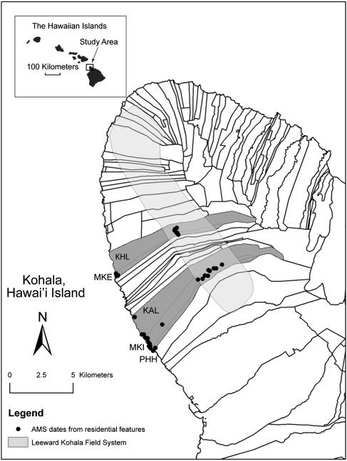
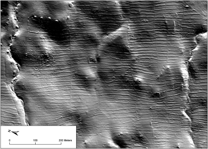
The Leeward Kohala Field System (LKFS) extends over ∼60 km2 on the leeward slopes of Kohala Peninsula on Hawai‘i Island (Fig. 1), demarcating an ancient zone of intensive agriculture. The LKFS is defined by a reticulate network of stone and earthen alignments (sometimes labeled in previous literature as “walls”) that run parallel to the slope contours (16, 17, 19–21). The field alignments are crosscut perpendicularly by curbstone-lined trails, causeway trails, and cleared trails that extend from the coast through the LKFS, serving both as conduits for people and as boundaries between territories. Major territories, called ahupua‘a (see Fig. 1) were controlled by chiefs and were often subdivided into smaller segments called ‘ili (22–24). The characteristic crosscutting pattern of field alignments and trail boundary segments is visible in Fig. 2.
Fig. 1.
Map of Kohala, Hawai‘i, showing the central study area [the ahupua‘a of Kaiholena (KHL) and Makeanehu (MKE)] and the southern study area [the ahupua‘a of Kālala (KAL), Makiloa (MKI), and Pahinahina (PHH)]. The extent of the Leeward Kohala Field System and the location of residential features dated with AMS radiocarbon dates are also indicated.
Fig. 2.
LiDAR image of the Kaiholena–Makeanehu study area (see Fig. 6) showing crosscutting pattern of field alignments (running roughly north–south) and trail boundary segments (running roughly east–west). Several individual household enclosures are also visible. See Fig. 6 for a map of the same area. Image courtesy of Greg Asner.
The Kohala peninsula was settled ca. A.D. 1100–1200 in the windward valleys (25, 26) and between A.D. 1200 and 1400 along the leeward coast and within the area of the LKFS (20). The LKFS was first defined archaeologically by Newman (27), who used aerial photography. Numerous archaeological investigations have made the LKFS one of the best-studied prehistoric agricultural field systems not only in Hawai‘i but also in Oceania (12, 14, 16–21, 28, 29). Mapping and excavation of field border alignments and trails within the LKFS have established a relative chronology for portions of the field system, and radiocarbon dating has identified five phases of construction, with a sequence of expansion into increasingly marginal parts of the agro-ecosystem, followed by segmentation (addition of new trail-territorial boundaries) and intensification (insertion of new field alignments resulting in decreased plot size). Subdivision of early phase large agricultural plots into smaller parcels provides evidence of late-stage intensification that is hypothesized to relate to demographic growth and to increased demands for surplus on the part of the chiefly class. This process spanned the centuries A.D. 1400–1800, a period during which an archaic state emerged out of formerly competing chiefdom polities on the Island of Hawai‘i (15, 30–32).
The Hawai‘i Biocomplexity Project investigated the biogeochemical properties of the leeward Kohala slopes, including critical soil nutrient gradients (12) and depletion (33), and applied the derived parameters to model potential agricultural productivity and its demographic correlates such as life expectancy (34, 35). These models indicate spatial and temporal variation across the LKFS, with the central core of the field system being more optimal (in terms of available food and hence life expectancy) than the southern and northern margins. These findings predict that processes of agricultural intensification should have followed somewhat different pathways in the core versus the margins of the LKFS.
Household Archaeology in the LKFS
Households were the fundamental economic units of production and consumption within ahupua‘a territories and occupied a critical nexus between agricultural production, demography, and social organization. A portion of the production of commoner households passed upward through the hierarchy as tribute to the land managers, territorial and district chiefs, and ultimately to the king (15, 23, 24, 31, 32). Rosendahl (28, 29) demonstrated that residential features were abundant within the LKFS. Subsequent archaeological studies, however, focused almost exclusively on evidence for agricultural activities rather than residential patterning. As a result, we know relatively little about the role that households played within the process of intensification in the LKFS. To redress this, from 2007 to 2009 we intensively mapped and excavated a range of residential features within two sample zones of the LKFS and its adjacent coastal region (32). Our sampling units are indvidual ahupua‘a, the traditional land units that were controlled by individual chiefs, which were the principal economic units of the emergent Hawaiian archaic state (15, 23, 24, 36).
Ancient household units in Hawai‘i are represented archaeologically by clusters of small stone and earthen structures, including terraces, enclosures, and small semicircular stone shelters (37–40). In the LKFS, larger residential features are identifiable by constructed terraces with stout stone walls on the upslope (windward) side of these structures, which served as windbreaks and anchored the perishable thatch superstructures (Fig. S1 A and F). Natural bedrock outcrops were also used for habitation and were modified with abutting stone-faced terraces and stacked stone-wall enclosures. Within the LKFS, low enclosing walls surrounding groups of features are also a common type of residential site (Fig. S1D). Excavations typically reveal thin cultural deposits (∼20–40 cm thick) with hearth and earth-oven combustion features (Fig. S1C). Residential features usually occur in small clusters of three to five features, reflecting the ethnographically attested kauhale residence system in which activities such as cooking, eating, and sleeping were carried out in separate structures (22, 41).
Our selection of ahupua‘a for household sampling is described in Materials and Methods; the location of sampling areas is shown in Fig. S2. The Kaiholena–Makeanehu study area consists of two adjacent ahupua‘a in the central, highly intensified core of the LKFS (Fig. 1). The second study area encompasses the three adjacent ahupua‘a of Kālala, Makiloa, and Pahinahina within the southern, more marginal part of the LKFS.
Results
Macroscale: Chronology of Residential Features in the LKFS.
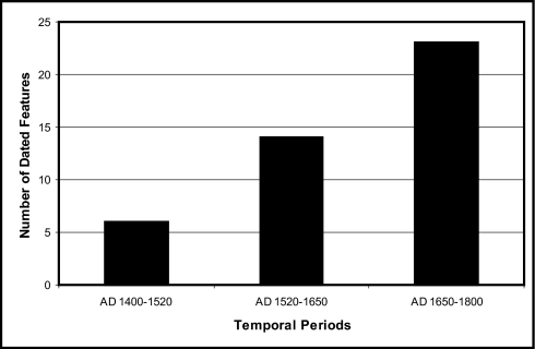
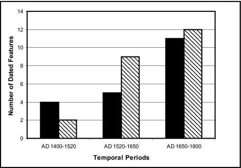
The temporal distribution of 43 dated residential features (Fig. 3) indicates a trend of exponential increase (exponential curve fit with R2 = 0.98) in the number of such features—and, by inference, in the number of households—over time. The temporal distribution of 14C-dated residential features according to whether features are located in the coastal sector or within the inland field system also exhibits a pattern of exponential increase (Fig. 4). In both cases, the greatest number of dated residential features is in the temporal period from A.D. 1650 to 1800, immediately before European contact. These trends indicate that the number of households associated with the LKFS increased over the period that the field system was intensified, with the greatest number of households in the final 150 y before European contact.
Fig. 3.
Temporal distribution of the number of dated residential features in Leeward Kohala (coastal and inland combined). Dated features are distributed within the three temporal periods: A.D. 1400–1520, A.D. 1520–1650, and A.D. 1650–1800.
Fig. 4.
Temporal distribution of the number of dated residential features in Leeward Kohala from the coast (black bars) and inland (shaded bars) portions of the study areas. Dated features are distributed within the three temporal periods: A.D. 1400–1520, A.D. 1520–1650, and A.D. 1650–1800.
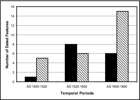
Fig. 5 plots the temporal distribution of 14C-dated residential features according to the two study areas. The sample size for Kaiholena–Makeanehu is smaller (n = 15) than that for the Kālala–Makiloa–Pahinahina area (n = 26); nonetheless, the temporal patterns between the two areas are significantly different. Whereas the Kālala–Makiloa–Pahinahina sample shows the same exponential pattern of increase in number of residential features over time (exponential curve fit with R2 = 0.87), that from Kaiholena–Makeanehu shows a slight decline in the number of features from temporal periods II to III. The Kaiholena–Makeanehu trend displays a poor fit to an exponential curve (R2 = 0.63) and better fits a power function (R2 = 0.77) or polynomial function (R2 = 1). These data suggest that the number of households in the central core of the LKFS stabilized between A.D. 1520 and 1650, whereas in the southern marginal zone the number of households continued to increase at an exponential rate. We discuss the implications of this further below.
Fig. 5.
Temporal distribution of the number of dated residential features in the central (Kaiholena–Makeanehu, black bars) and southern (Kālala–Makiloa–Pahinahina, shaded bars) study areas. Dated features are distributed within the three temporal periods: A.D. 1400–1520, A.D. 1520–1650, and A.D. 1650–1800.
The spatial distribution of radiocarbon-dated residential features within the Makiloa portion of the LKFS (Fig. S2D) is of particular interest. The earliest dated features (MKI-300, -303) belonging to temporal period I are located in the mid and upper elevational range of the field system where rainfall is more predictable and agricultural production is less risky (12, 30). Features added during temporal period II also are found in this mid-to-upper sector, whereas features added during temporal period III (MKI-198B, -306, -307) were located near the lower elevational limit of the field system, where rainfall is more variable and risk consequently higher. These data suggest that during the final period of intensification in the southern margins of the LKFS some households were pushing into the lower elevation, higher-risk parts of the farming area.
Microscale: Household Expansion and Territorial Segmentation in the Field System Core.
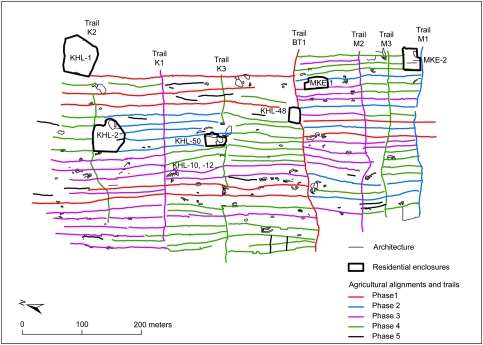
The inland Kaiholena–Makeanehu study area, located in the central core of the LKFS, revealed a pattern of closely spaced agricultural field alignments that are crosscut by trail segments and abutted residential features (Fig. 2 and Fig. S2B). As shown in detail in Fig. 6, the trail segments subdivide this part of the LKFS into seven distinct territorial units. The trail labeled BT1 in Fig. 6 follows the ethnohistorically documented boundary between the ahupua‘a of Kaiholena (on the north) and that of Makeanehu (on the south). Ladefoged and Graves (19) interpret this boundary as part of an early phase of ahupua‘a territory division in Kohala district, with Makeanehu originally being part of a land unit to its south (Kaupalaoa). Trails K1, K2, and K3 further segment Kaiholena into smaller units, and trails M1, M2, and M3 do the same for Makeanehu (Fig. 6). Our archaeological survey revealed that a series of residential enclosures in this area appeared to correspond to the specific territorial units. We incorporated residential feature data with survey data from field alignment and trail abutments to test the hypothesis that the sequence of territorial segmentation was matched by the construction of new residences, indicating the linked establishment of households and territories over time.
Fig. 6.
Map of the Kaiholena–Makeanehu area showing the relative chronology of agricultural alignments, trails, and residential enclosures as indicated by feature abutment. Suggested phases of construction are indicated by color. The division between the ahupua‘a of Kaiholena and Makeanehu is indicated by the BT1 trail. The extent of residential enclosure walls is indicated by dark borders; agricultural features are indicated by small polygons. See Fig. 2 for a LiDAR image of the same area.
The matching and mismatching patterns of trails and field border alignments within the LKFS provides a basis for defining a relative chronology of construction (16, 17, 19–21). Ladefoged et al. (17) provide a set of ordering rules for the temporal construction of agricultural alignments and trails in the LKFS. These rules use ratios of abutments between agricultural alignments and trails as the primary indices for the designation of temporal units. Ladefoged and Graves (19) used a similar set of principles to define the relative order of construction phases in a sample area of the LKFS. The primary assumption is that “when a wall [alignment] terminates at a trail, forming an offset with surrounding walls, it was built later than, or at the same time, as the trail” (16 p 431).
Some residential enclosures in the LKFS are abutted by agricultural alignments, whereas in other areas the residential enclosure walls are built on top of and incorporate alignments. These configurations provide a relative order of agricultural and residential feature construction, allowing us to apply the following rules: (i) agricultural alignments that abut a residential feature can be assigned to the same temporal unit, or later, than the residential feature and (ii) residential features constructed on top of, or incorporating, agricultural alignments can be assigned to a later temporal unit than the agricultural alignment. We used the above stated ordering principles to build a hypothetical sequence for the development of this intensive agricultural landscape, with five discrete phases (see SI Text for details).
We determined the following relative chronology for residential enclosures in Kaiholena and Makeanehu: KHL-1 was constructed during or before phase 1; KHL-48, KHL-50, and MKE-1 were constructed during or before phase 2; and KHL-2 was constructed during or after phase 2. MKE-2 was constructed after phase 2, but before phase 4. KHL-10 and KHL-12 cannot be connected to any of the construction phases. The hypothesized sequence of territorial segmentation and construction of new residential features is graphically summarized in Fig. S3.
We tested this hypothesized set of temporal associations with Bayesian analysis of the radiocarbon dates from the residential structures (see SI Text for details of Bayesian analysis). A total of 11 radiocarbon dates were obtained from samples excavated from residential features in Kaiholena and Makeanehu (Table S1). For Kaiholena, the Amodel index for the construction sequence-based model indicates that the sequence of events ordered by the model are in an acceptable chronological relationship (Fig. S4A and Table S2). Examination of the highest posterior densities for the modeled dates indicates that the start of the construction sequence occurred between A.D. 1511 and 1797. The temporal associations of the Kaiholena residences in the study area follow in sequential and overlapping age ranges: A.D. 1524–1795, A.D. 1616–1798, A.D. 1629–1798, and A.D. 1644–1801. The final sequence spans A.D. 1646–1820, although Kaiholena lacks residential features from this portion of the sequence. Makeanehu had fewer residential features and dated occupations, resulting in a model that contains four sequences but only two events. As a result, the construction phases represented by the model's boundaries are much longer (Fig. S4B and Table S2).
The Amodel index for the Makeanehu model indicates that these lengthy sequences are in an acceptable chronological order. Boundary 1, which models the start of phase 1 construction, dates from A.D. 1024 to 1793. All of the residences in the Makeanehu study area are modeled to date to A.D. 1488–1799 and A.D. 1667–1917. The final phase 4 construction is dated to A.D. 1675–1928. Comparison of these results with random models for Kaiholena and Makeanehu (Table S2) indicate that the temporal sequence of residences is unlikely to be due to chance.
Discussion
Sampling of residential features from two study areas in leeward Kohala reveals a chronology of household expansion spanning three temporal periods between A.D. 1400 and 1800. The overall pattern is one of an exponential rate of increase in residential features, with the greatest number of such features existing in temporal period III (A.D. 1650–1800), just before European contact. This chronology fits well with the previously established chronology of agricultural system intensification for the LKFS outlined by Ladefoged and Graves (20) and based on a series of 33 radiocarbon dates, primarily from agricultural field alignments within the southern part of the system. Their data show a pattern of late intensification (marked by increased field alignment construction) after A.D. 1650. However, Ladefoged and Graves (20) also suggested that there was no residential occupation in this part of the LKFS before A.D. 1640, although they noted that this might be a reflection of sampling bias. Our expanded excavation sample of residential sites both in the central core and in the southern margins of the LKFS indicates that households were indeed incorporated within the field system from its earliest phases. Our analyses further indicate that the greatest increase in households in temporal period III took place within the southern marginal area, and not in the central core where the number of households apparently stabilized before A.D. 1650.
On a smaller spatial scale, our construction sequence-based modeling and radiocarbon analysis indicates that the two ahupua‘a territories of Kaiholena and Makeanehu within the core of the LKFS were already demarcated before the construction of agricultural field alignments in the area. Agricultural development in the following decades and centuries included a series of subdivisions of lands that were adjacent to residential features. The pattern of early expansive construction (the phase 1 alignments and trails) indicates that the lands in both ahupua‘a were developed over time as farmers established new fields and farmsteads. The lands of both ahupua‘a were progressively subdivided with new trails and alignments (such as phase 3 constructions), as preexisting territorial segments were carved into smaller units. This reflects a process of continued agricultural intensification related to household expansion and, by inference, to population growth, but it likely also was associated with an increase in managerial presence and a desire to produce higher yields (see below). Building on previous studies of the LKFS that have demonstrated the utility of analyzing alignments and trails to reveal the relative chronology and pace of agricultural intensification (16, 19), our inclusion of residential features in the analysis provides a more direct index of household growth over time and reveals the sequence of newly emerging socioeconomic units.
Residential features KHL-10 and KHL-12 could not be integrated into the relative construction sequence model due to their lack of abutment with field alignments (Fig. S3). These two features, which consist of simple C-shaped stone structures and terraced outcrops, contain cultural deposits and combustion features that date to A.D. 1465–1645 (at 1 SD), or temporal period I. It is likely that these residences were constructed and occupied before or during the construction of the BT1 trail and the expansion of the phase 1 alignments. The close proximity of several alignments of this phase immediately west of KHL-10 further implies that these residential features may be associated with the initial construction of the LKFS and the establishment of the ahupua‘a boundary between Kaiholena and Makeanehu.
In Kaiholena, the KHL-1 residence and the contiguous BT1 trail and phase 1 alignments presumably delineate the spatial extent of the earliest landholding social unit. The residences of KHL-50 and KHL-48 thus represent units that were established later, followed in the final phase by KHL-2. In Makeanehu, the establishment of residences and agricultural alignments occurred slightly later and covered a smaller area. However, the pattern is the same: the initial extent of MKE-1 and phase 1 and 2 alignments are subdivided later with trails and alignments and followed by the establishment of additional features and the residence of MKE-2.
The distribution of the alignments and the existence of the BT1 trail suggest that initial agricultural production during phase 1 was coordinated at the level of the ahupua‘a and managed by a single social group. During phase 2 three additional residential clusters were established, and the ahupua‘a was subdivided with new agricultural alignments inserted predominantly between the new residences and trails. These residences were regularly situated across the landscape, suggesting a purposeful subdivision of the original ahupua‘a into smaller units that were managed by individual households. This pattern is subsequently replayed in phases 3 and 4 when large extents of land were added to the system with the establishment of new trails, and these were then subdivided with agricultural alignments into even smaller units. This pattern of growth and division suggests that phases 1 and 3 represent the establishment of larger households and investment in the intensification of the field system. Phases 2 and 4 thus appear to be periods when new households were added (probably through a process of household fission); this was associated with new subdividing of land for agricultural production, resulting in a greater number of socioeconomic units.
By the time of European contact, the surveyed areas of Kaiholena and Makeanehu contained six distinct socioeconomic units, the boundaries of which are indicated by the trails that cross the gently sloping topography of leeward Kohala. These units most likely represent the traditional ‘ili subdivisions that were farmed by local households and managed by an administrator, or konohiki, who was appointed by the chief of the ahupua‘a, the ali‘i ‘ai ahupua‘a (15, 23, 24). The subdivision of land by trails and the establishment of new households and ‘ili suggest that household production within ahupua‘a was a planned and closely regulated process. On the basis of this residential chronology and the relative chronology of alignments and trails, we argue that this socioeconomic system had its origins with the initial settlement of the field system area during phase 1, ca. A.D. 1400–1500, but became more intensively managed during phases 2 and 3, sometime between ca. A.D. 1600 and 1800. Increased management would have facilitated the collection of tribute by the chiefly hierarchy, which became increasingly important as the sociopolitical system was transformed from a chiefdom to an archaic state (14, 15).
Although we have refrained from attempting to infer population sizes from our residential site data, the increases in numbers of households through the three temporal periods that we are able to resolve with our radiocarbon dates have obvious demographic implications. Assuming that average household size remained constant over time, then the exponential increase in total number of residential features should be a proxy indication that the total population of Kohala district was increasing and that the maximum population was reached in the 150-y period just before European contact. This was a period marked by increased frequency and intensity of interpolity conflict and warfare, especially between the emergent archaic states of Hawai‘i and Maui Islands (14). We plan to explore such demographic implications in future work, combining our residential survey data with modeling of potential productivity and food ratios for our study areas (35, 42).
Conclusion
Archaeological survey and excavation of residential sites within the LKFS provide a chronology for expansion of household units and permit an analysis of the spatial relationships linking residential sites with abutting agricultural features in a complex agrarian landscape. We have examined two study areas on a macroscale that includes both coastal and upland regions and on a microscale that focuses on the distribution of individual residential and agricultural features with the LKFS itself. Our results augment previous studies of the expansion and intensification of the LKFS, showing how household units were an essential part of this system and how they were integrally linked with territorial units. Our methods include a radiometric chronology of residential features, a relative chronology based upon feature abutment, and a Bayesian analysis of radiocarbon dates using temporal groups defined by architectural data. Our analyses indicate that agricultural expansion and intensification within the LKFS occurred in tandem with the establishment of new households and with the subdivision of the landscape into progressively smaller socioeconomic units. The higher frequency of residences within the core area of the field system, as well as the initial expansion of field system trails and alignments that demarcate major land divisions, suggests that this process was managed from the outset. On the basis of ethnohistoric documents from the 18th and 19th centuries, we suggest that such management was performed by elites, who were required to generate surplus at the level of the ahupua‘a. Population growth, coupled with increased management and tribute requirements, supported the increasingly hierarchical sociopolitical system of archaic states that emerged in Hawai‘i ca. A.D. 1600–1800 (15). The approach developed here, with its focus on the linked processes of population growth, agricultural intensification, and the development of socioeconomic units, may be applicable to the study of intensive agricultural landscapes in other parts of the world.
Materials and Methods
Archaeological landscapes with residential features were sampled in two areas: (i) the adjacent ahupua‘a territories of Kālala, Makiloa, and Pahinahina in the southern part of the LKFS (survey area 19 km2) and (ii) the adjacent territories of Kaiholena and Makeanehu in the central core of the LKFS (survey area 13 km2). Both areas were intensively surveyed using submeter Trimble GeoXH GPS data recorders; a total of 748 residential features were identified and mapped. A total of 78 units were excavated within a sample of 57 residential features (7.6% of total features). Charcoal samples from short-lived native shrubs and candlenut endocarps (Aleurites moluccana) obtained from subsurface cultural deposits in the residential sites were selected for accelerator mass spectrometry radiocarbon dating (AMS). Forty-three of the 57 excavated residential features were dated with 48 AMS radiocarbon dates. Measured ages were calibrated using OxCal 4.1 with the IntCal04 calibration curve (43). Details of radiocarbon determinations are provided in Table S1. Further information on Bayesian analysis of the radiocarbon dates is provided in SI Text.
Supplementary Material
Acknowledgments
We thank the State of Hawai‘i Department of Land and Natural Resources, the State Historic Preservation Office, and Parker Ranch for permission to carry out archaeological research on state and private lands. We also thank Marjeta Jeraj for identifying the charcoal remains and Paul Patton for assistance with the laboratory analyses. The research reported here was funded by National Science Foundation Human Social Dynamics program Grant BCS-0624238. Additional financial support was provided by the Class of 1954 Fund of the University of California, Berkeley; the University of Auckland; and the Royal Society of New Zealand Marsden Fund.
Footnotes
The authors declare no conflict of interest.
This article contains supporting information online at www.pnas.org/lookup/suppl/doi:10.1073/pnas.1103805108/-/DCSupplemental.
References
- 1.Brookfield HC. Intensification and disintensification in Pacific agriculture. Pac Viewp. 1972;13:30–47. [Google Scholar]
- 2.Boserup E. The Conditions of Agricultural Growth: The Economics of Agrarian Change Under Population Pressure. Chicago: Aldine; 1965. [Google Scholar]
- 3.Brookfield H, Hart D. Melanesia: A Geographical Interpretation of an Island World. London: Methuen; 1971. [Google Scholar]
- 4.Turner BL, Doolittle WE. The concept and measure of agricultural intensity. Prof Geogr. 1978;30:297–301. [Google Scholar]
- 5.Leach H. Intensification in the Pacific. Curr Anthropol. 1999;40:311–339. [Google Scholar]
- 6.Bassett TJ. The Peasant Cotton Revolution in West Africa: Cote d'Ivoire, 1880–1995. Cambridge, UK: Cambridge University Press; 2001. [Google Scholar]
- 7.Morrison K. Typological schemes and agricultural change: Beyond Boserup in South India. Curr Anthropol. 1996;37:583–608. [Google Scholar]
- 8.Morrison K. Rethinking intensification: Power relations and scales of analysis in precolonial South India. In: Thurston TL, Fisher CT, editors. Seeking a Richer Harvest: The Archaeology of Subsistence Intensification, Innovation, and Change. New York: Springer Scientific Publishing; 2006. pp. 235–248. [Google Scholar]
- 9.Morrison KD. The intensification of production: Archaeological approaches. J Archaeol Method Theory. 1994;1:111–159. [Google Scholar]
- 10.Kirch PV. Agricultural intensification: A Polynesian perspective. In: Marcus J, Stanish C, editors. Agricultural Strategies. Los Angeles: Cotsen Institute of Archaeology Press; 2006. pp. 192–217. [Google Scholar]
- 11.Johnston KJ. The intensification of pre-industrial cereal agriculture in the tropics: Boserup, cultivation lengthening, and the classic Maya. J Anthropol Archaeol. 2003;22:126–161. [Google Scholar]
- 12.Vitousek PM, et al. Soils, agriculture, and society in Precontact Hawaii. Science. 2004;304(11 June):1665–1669. doi: 10.1126/science.1099619. [DOI] [PubMed] [Google Scholar]
- 13.Kirch PV, et al. Environment, agriculture, and settlement patterns in a marginal Polynesian landscape. Proc Natl Acad Sci USA. 2004;101:9936–9941. doi: 10.1073/pnas.0403470101. [DOI] [PMC free article] [PubMed] [Google Scholar]
- 14.Kirch PV, editor. Roots of Conflict: Soils, Agriculture, and Sociopolitical Evolution in Ancient Hawai‘i. Santa Fe, NM: School for Advanced Research Press; 2010. [Google Scholar]
- 15.Kirch PV. How Chiefs Became Kings: Divine Kingship and the Rise of Archaic States in Ancient Hawai‘i. Berkeley: University of California Press; 2010. [Google Scholar]
- 16.Ladefoged TN, Graves MW. Evolutionary theory and the historical development of dry land agriculture in North Kohala, Hawai‘i. Am Antiq. 2000;65:423–448. [Google Scholar]
- 17.Ladefoged TN, Graves MW, McCoy M. Archaeological evidence for agricultural development in Kohala, Island of Hawai‘i. J Archaeol Sci. 2003;30:923–940. [Google Scholar]
- 18.Ladefoged TN, et al. Opportunities and constraints for intensive agriculture in the Hawaiian archipelago prior to European contact. J Archaeol Sci. 2009;36:2374–2383. [Google Scholar]
- 19.Ladefoged TN, Graves MW. The formation of Hawaiian territories. In: Lilley I, editor. Archaeology of Oceania: Australia and the Pacific Islands. Malden, MA: Blackwell Publishers; 2006. pp. 259–283. [Google Scholar]
- 20.Ladefoged TN, Graves MW. Variable development of dryland agriculture in Hawai‘i: A fine-grained chronology from the Kohala Field System, Hawai‘i Island. Curr Anthropol. 2008;49:771–802. [Google Scholar]
- 21.Ladefoged TN, Graves MW, Jennings RP. Dryland agricultural expansion and intensification in Kohala, Hawai‘i Island. Antiquity. 1996;70:861–880. [Google Scholar]
- 22.Handy ESC, Pukui MK. The Polynesian Family System in Ka-‘u, Hawai‘i. Wellington, New Zealand: The Polynesian Society; 1958. [Google Scholar]
- 23.Chinen JJ. The Great Mahele: Hawai‘i's Land Division of 1848. Honolulu: University of Hawaii Press; 1958. [Google Scholar]
- 24.Sahlins MD. Historical Ethnography. Anahulu: The Anthropology of History in the Kingdom of Hawai‘i. Chicago: University of Chicago Press; 1992. [Google Scholar]
- 25.Field JS, Graves MW. A new chronology for Pololu Valley, Hawai‘i Island: Occupational history and agricultural development. Radiocarbon. 2008;50:205–222. [Google Scholar]
- 26.McCoy M, Graves MW. The role of agricultural innovation on Pacific Islands: A case study from Hawai‘i Island. World Archaeol. 2010;42:90–107. [Google Scholar]
- 27.Newman TS. Hawaiian Fishing and Farming on the Island of Hawaii in AD 1778. 1970. (Division of State Parks, Department of Lands and Natural Resources, Honolulu, Hawaii) [Google Scholar]
- 28.Rosendahl PH. Aboriginal Hawaiian structural remains and settlement patterns in the upland agricultural zone at Lapakahi, Island of Hawai‘i. Hawaiian Archaeol. 1994;3:14–70. [Google Scholar]
- 29.Rosendahl PH. Manoa, Honolulu: University of Hawaii; 1972. Aboriginal agriculture and residence patterns in Upland Lapakhi, Island of Hawai‘i. PhD thesis. [Google Scholar]
- 30.Graves MW, O'Connor BV, Ladefoged TN. Tracking changes in community-scaled organization in Kohala and Kona, Hawai‘i Island. In: Ladefoged TN, Graves MW, editors. Pacific Landscapes: Archaeological Approaches. Los Osos, CA: Easter Island Foundation Press; 2002. pp. 231–254. [Google Scholar]
- 31.Cordy R. Exalted Sits the Chief: The Ancient History of Hawaii Island. Honolulu: Mutual Publishing; 2000. [Google Scholar]
- 32.Field JS, Kirch PV, Kawelu K, Ladefoged TN. Households and hierarchy: Domestic modes of production in Leeward Kohala, Hawai‘i Island. J Island Coastal Archaeol. 2010;5:52–85. [Google Scholar]
- 33.Meyer M, Ladefoged TN, Vitousek P. Soil phosphorus and agricultural development in the Leeward Kohala Field System, Island of Hawai‘i. Pac Sci. 2007;61:347–353. [Google Scholar]
- 34.Ladefoged TN, Lee C, Graves MW. Modeling life expectancy and surplus production of dynamic pre-contact territories in leeward Kohala, Hawai‘i. J Anthropol Archaeol. 2008;27:93–110. [Google Scholar]
- 35.Lee C, Tuljapurkar S, Vitousek P. Risky business: Temporal and spatial variation in preindustrial dryland agriculture. Hum Ecol. 2006;34:739–763. [Google Scholar]
- 36.Earle TK. How Chiefs Come to Power. Stanford, CA: Stanford University Press; 1997. [Google Scholar]
- 37.Kolb MJ, Snead JE. It's a small world after all: Comparative analyses of community organization in archaeology. Am Antiq. 1997;62:609–628. [Google Scholar]
- 38.Cordy R, Kaschko M. Prehistoric archaeology in the Hawaiian Islands: Land units associated with social groups. J Field Archaeol. 1980;7:403–416. [Google Scholar]
- 39.Weisler MI, Kirch PV. The structure of settlement space in a Polynesian chiefdom: Kawela, Moloka’i, Hawaiian Islands. New Zealand J Archaeol. 1985;7:129–158. [Google Scholar]
- 40.Ladefoged TN. Hawaiian architectural transformations during the early historic era. Asian Perspect. 1991;30:57–69. [Google Scholar]
- 41.Malo D. In: Hawaiian Antiquities trans Emerson NB. rev. ed. Emerson NB, translator. Honolulu: Bernice P. Bishop Museum Press; 1951. [Google Scholar]
- 42.Lee CT, Tuljapurkar S. Population and prehistory I: Food-dependent population growth in constant environments. Theor Popul Biol. 2008;73:473–482. doi: 10.1016/j.tpb.2008.03.001. [DOI] [PubMed] [Google Scholar]
- 43.Bronk Ramsey C. Bayesian analysis of radiocarbon dates. Radiocarbon. 2009;51:337–360. [Google Scholar]
Associated Data
This section collects any data citations, data availability statements, or supplementary materials included in this article.


