

Abstract
Marine protected areas (MPAs) are critical to the well-being of threatened ecosystems and thus can be highly beneficial to humans, especially to those residing nearby. We explore the qualities of 117 MPAs in the Mediterranean basin and develop a taxonomy of their characteristics. We relate the spatial distribution of the MPAs to the various characteristics of the taxonomy (size, distance from shore, protection levels, management regimes, etc.) and to areas of high human impact and influence levels. To do this we use information on biogeographic regions and information from two different human influence models; one model developed for the marine environment and one covering the littoral terrestrial environment. Our analysis provides insights to planners and managers working in a regional capacity and trying to build MPA networks. Generally, current MPAs have not been established in high impact areas despite their being close to shores containing intense human activity. Decision-makers wishing to design and establish new MPAs may seek out areas of high cumulative human impacts (near the marine–terrestrial interface) or avoid them depending on marine conservation objectives, including the desire to vary types of MPAs within a network. Limitations of our analysis and methodology indicate areas for further research.
Keywords: Marine protected areas, Mediterranean, Protection levels, Spatial distribution, Human activity, Human impacts
Introduction
Many studies and reports indicate that ocean ecosystems are being disrupted and depleted with serious consequences (e.g., Hassan et al. 2005; Rogers and Laffoley 2011). Overfishing, pollution, habitat loss, climate change, ocean acidification, and introduction of non-native species are serious threats. These threats result in the loss of many benefits, including healthy seafood, resilient economies and jobs, cultural and recreational opportunities, vibrant coastal communities, protection against natural hazards, wildlife, and even clean drinking water (Lubchenco and Sutley 2010). Marine experts and conservationists see great hope in the opportunities provided by marine protected areas (MPAs) to counter threats to marine ecosystems.
The Mediterranean Sea’s environment is impressive considering its limited dimensions: 0.82 % of the surface area and 0.32 % of the volume of the global ocean. Its waters and surrounding environment are one of the world’s priority conservation regions due to high numbers of endemic species, great biodiversity, varied ecosystems, and the need to counter escalating human pressures (Hinrichsen 1998; Myers et al. 2000). The 22 countries abutting the Mediterranean Sea have a collective population of approximately 477 million people. About a third of them, together with 150 million seasonal tourists, live along the sea’s 46 000 km coastal plain. Development to meet the needs of burgeoning populations has repercussions to the marine environment (Rogers and Laffoley 2011). Recognition of these factors coincides with recent calls for the establishment and improved design of MPAs (Bianchi and Morri 2000; Maiorano et al. 2009).
Definitions of MPAs vary from exclusionary to inclusionary. A recently revised IUCN definition of what constitutes a protected area (PA) emphasizes the conservation purpose of geographical space. “Conservation” is defined as the in situ maintenance of ecosystems and natural and semi-natural habitats and of viable populations of species in their natural surroundings (Dudley 2008). Prohibition or restriction of activities within a PA is usually part of the in situ maintenance. For marine sites this engenders unique management opportunities and challenges. For example, depth can be very significant in a MPA (Agardy 2000); it is difficult or impossible to put up “fences” around MPAs (Dudley 2008); and exploitation of resources adjacent to a reserve for commercial fishing must frequently be reconciled with conservation goals (Gaines et al. 2010).
Conservation planners often categorize PAs according to their objectives and/or the level of human intervention allowed within. Such categorization is useful for regional planning and for the creation of PA networks including sites of different types, and levels of protections (Planes et al. 2000; Bishop et al. 2004; López-Ornat et al. 2007). Identifying gaps in coverage vis-á-vis physical environmental attributes and protection levels can advance the designation of representative systems of MPAs as required by international agreements and can help identify areas for networks of related reserves (for example, within a similar ecoregion).
It is also important to understand whether MPAs are sited in areas of high or low human impact levels. This can provide insights to protection tendencies, i.e., whether or not PAs tend to be accessible to nearby populations or whether they are located in pristine, undisturbed areas far from centers of human activities. Documentation of MPA coverage in the Mediterranean that considers human impact levels fails to consider terrestrial activities (e.g., Coll et al. 2011) yet the synthesis of marine and terrestrial layers of human impacts is important. Integrative approaches such as ecosystem-based management, integrated coastal zone management and marine spatial planning (MSP) call for the crossing of land and sea boundaries (Olsen et al. 2011; Portman and Fishhendler 2011).
Our aim is to provide information about trends and gaps in MPA coverage that can help direct marine conservation efforts in the Mediterranean Sea. After describing our method of analysis and presenting results, our discussion summarizes the potential contribution of this analysis to the planning of regional MPA networks, particularly in view of global perspectives on marine protection. The discussion also highlights limiting factors related to the methodology that require further research.
Materials and Methods
The steps we followed initially determined a working definition of what is an MPA so as to decide which PAs would be included in our study. We then chose appropriate attributes for our taxonomy based on reliable information available and what would be helpful to know about each MPA. We created a GIS database of all MPA attributes, including exact location and extent. These steps allowed analysis of the spatial distribution of MPAs based on characteristics and human impact levels. The latter step considers characteristics of the MPAs (e.g., level of protection) as well as their physical location (see Fig. 1).
Fig. 1.
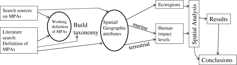
The workflow (ellipses indicate decision points in the process)
For our purposes, an MPA is: “A clearly defined geographical space, recognized, dedicated and managed, through legal or other effective means, to achieve the long-term conservation of nature with associated ecosystem services and cultural values” (Dudley 2008). We use a restrictive (exclusionary) definition of MPAs emphasizing conservation objectives, also used by the IUCN. Our definition excludes proposed MPAs (e.g., those indicated as “proposed” in a recent report to the European Commission (Policy Research Corporation 2011)). We included ocean island reserves only if they contain submerged areas around them. Coastal lagoons, inlets, wetlands, and enclosed bays were not included although they may be tidal-influenced environments. Areas managed strictly for commercial fishery goals were also not included in our list.
We used MedPan, Protected Planet, and MPA Global (Wood 2007) databases together with academic and professional literature to gather information on the MPAs. We cross-referenced the information with at least two sources. For geographic location, the three databases were unreliable, with frequent contradictions and lack of precision. For all, but 20 MPAs we created GIS polygons based on plans posted on websites or by georeferencing maps we found in the literature. The remaining 20 MPAs for which we did not have a referenced polygon were drawn based on two parameters: size and location. We created a square around a centroid point located at the geographical coordinates of the MPA we gleaned from websites or other media. We created a square proportional to the reported area of the MPA.
To facilitate comparisons with other regions of the world and similar research efforts (e.g., Guarderas et al. 2008), we assigned one of the following protection level categories to each MPA: (1) limited-take MPAs (some extractive activities allowed), (2) no-take MPAs (no extractive activities allowed, the highest level), and (3) mixed-use MPAs (a combination of limited-take and no-take within a single MPA). The latter category presumes the use of a zoning system or buffers with at least one core area and corresponding periphery (referred to as “multiple-use” MPAs by Bishop et al. (2004) and Mackelworth et al. (2008)). We obtained information about levels of protection and prohibited or allowed activities from the sources described earlier and from personal communication with MPA managers in various countries (see Acknowledgments). We also collected information from publications by Broquere (2005), Abdulla et al. (2008), MedPAN (2010) and from the Policy Research Corporation (2011) country reports.
We distinguished between marine reserves designated at a national level and at an international level. The latter includes Natura2000, International Bird Areas, Specially Protected Areas of Mediterranean Importance (SPAMIs), and biosphere reserve designations. National MPAs are those only established and/or recognized in the particular country through local, provincial, or national-level legislation and management regulation. Unlike other studies, the MPAs we consider are not particularly focused on fisheries management (e.g., Gaines et al. 2010) but have been designated for a variety of reasons including preserving natural and cultural heritage, education, and research in “pristine” settings.
To support comparisons to global and other regional marine conservation efforts (e.g., Dudley 2008; Guarderas et al. 2008), we noted the IUCN’s management category listed in the reviewed databases. The IUCN uses seven classifications: Ia, Strict protection with absolutely no extraction allowed; Ib, significantly free of human disturbance with limited entry allowed to ensure a “wilderness feeling”; II, managed for ecosystem protection but with provision for tourism and recreation; III, conservation of nature monuments or features (e.g., seamounts); IV, protection of specific species or habitat with active intervention (e.g., no trawling); V, seascape conservation integrating interaction of people and nature; and VI, maintenance of natural habitats with sustainable collection of some elements (Dudley 2008).
To complete the database according to our taxonomy, we conducted gap analysis (Jennings 2000) by overlaying our MPA data layer with a jurisdictional boundary layer of the Flanders Marine Institute Geodatabase (VLIZ 2009), the marine bio-geographic data layer of Spalding et al. (2007) and the bathymetric depth layer of the British Oceanographic Data Centre (BODC 2011). The jurisdictional boundary layer determines the extent of territorial waters or past these out to a country’s exclusive economic zone (EEZ). According to the United Nations Convention of the Law of the Sea, territorial waters are delineated out to 12 nautical miles (nm) from the baseline (usually a country’s high-tide water mark) whereas the EEZ extends from the baseline to 200 nm.
The Marine Ecoregions of the World uses a nested system of 12 realms, 62 provinces, and 232 ecoregions (Spalding et al. 2007). This typology was developed based on physical conditions and representation of ongoing ecological processes. Due to its relatively high spatial resolution compared to earlier global classifications and practical utility, it has been used in previous studies of global marine environments and in the Mediterranean (e.g., Adbulla et al. 2008; Halpern et al. 2008).
High quality spatial data on anthropogenic threats to the health of ecosystems has become available in the last decade thus facilitating the third and final step of our study. To assess the relationship between the distribution of MPAs and human impacts, we utilized data generated by models of human impact covering marine and terrestrial environments. The terrestrial coasts are particularly important especially considering the proximity of most MPAs to the shoreline and related land-based activities. Our preliminary inventory showed that 51 % of the MPAs in the Mediterranean Sea are within 2 km from land; 48 % have terrestrial areas within them.
Sanderson et al. (2002) developed a technique for mapping the level of human activity in the terrestrial environment using geographic proxies. They developed human influence indices by overlaying data layers that represent the location of factors (human population distribution, urban areas, roads, navigable rivers, and various agricultural land uses) exerting an influence on ecosystems. The combined influence of the different factors is normalized by global biomes to create the Human Footprint data layer. The layer presents impact scores (HF) ranging from 1 to 100 at a resolution of 1 km2 cells (WCS 2011).
Halpern et al. (2008) developed a layer of cumulative human impacts scores (Ic) for the marine environment that provides scores in a global database ranging 0.01–90.1 presented in a raster layer of 1 km2 cells (NCEAS 2008). (We adopt the Ic notation.) The scores result from a spatial model that estimates ecosystem-specific differences in the impacts of 17 anthropogenic drivers of ecological change. Impact weights assigned by experts are combined with multiple drivers into a single comparable estimate of cumulative human impact on 20 ecosystem types.
We rescaled the marine layer (NCEAS 2008) and merged it with the HF layer (WCS 2011) for the Mediterranean Sea. We converted some missing data cells along the shoreline by using the FILTER function in the GIS software. The function performed a smoothing operation by averaging the surrounding non-zero scored cells (in 3 by 3 formation). Thus, we generated a continuous rescaled scored grid covering the sea and land area up to 50 km inland. The extent of the Mediterranean shoreline and its vast variety of ecosystems, prompted us to adopt a landward boundary of 50 km inland. This boundary is based on the least-restrictive coastal zone limit of 32 miles (51.5 km) landward from among the US states (Louisiana) (NOAA 2011).
We then analyzed the distribution of MPAs in relation to human impact (influence) levels by overlaying the MPA polygon layer and the combined marine and terrestrial human impact layer (using a CLIP function in the GIS software to overlay raster and vector data). The mean of all the cells within the MPA polygon gave us an average human impact score for each MPA dependent on its size and shape. We used the same process to calculate depth of each MPA and thus completed our attribute database, i.e., by combining and then ‘clipping’ the raster data of the depth layer with the vector data of the MPA polygons.
Results
Of the approximate 284 MPAs in the Mediterranean found by searching databases and reports, only 117 met our criteria for inclusion. Since establishment of the first MPA (1960), the number and area covered protected within them has increased steadily to 109 084 km2 in 2011. However, this represents only 3.8 % of the Mediterranean Sea area. Without the terrestrial area included within some MPAs, this figure is smaller: 105 023 km2. The largest jump occurred in 2002 when the multinational Pelagos Marine Sanctuary was established. At that time, total MPA increased from 11 077 to 100 464 km2.
The 117 MPAs range in size from 0.003 to 87 500 km2 with a mean (SD) of 932.41 (8067) km2. Seventy percent are less than 100 km2 in size with most (39 %) falling into the 10–100 km2 size category (see Fig. 2a), the size range recommended by Halpern and Warner (2003) for no-take reserves. Mediterranean MPAs are generally larger than in the Philippines where there are hundreds of small MPAs (90 % ≤ 1 km2) (Weeks et al. 2010) but smaller than Latin American/Caribbean MPAs where 40 % of MPAs fall into the 100–1000 size range (Guarderas et al. 2008). There are four MPAs over 1000 km2 in size. Fifteen MPAs (6.07 %) are less than 1 km2 with the smallest being the Sagone/Coggia MPA in France (0.003 km2).
Fig. 2.

a Size of MPAs in km2 by ecoregion, b number of MPAs according to use categories by ecoregion, c size of MPAs as a percentage of total ecoregion area
The most common level of protection is mixed-use (69 or 59 % of all MPAs) and no-take MPAs are by far the least common (8 or 6.8 %) (see Table 1; Fig. 2). In contrast, the 40 limited-take MPAs cover the largest area (93 191 km2—roughly 85 % of all the area protected by MPAs) compared to mixed-use MPAs (15 848 km2, 14.5 %). The contribution of no-take MPAs is minimal. This type of PA covers only 45.5 km2, making up less than 0.05 % of the total area protected.
Table 1.
Distribution of MPAs by World Conservation Union (IUCN) management category and level of protection (no-take, limited-take, and mixed-use) in the Mediterranean Sea
| Protection level | IUCN management categoriesa | ||||||||
|---|---|---|---|---|---|---|---|---|---|
| Ia | Ib | II | III | IV | V | VI | Unset | Total | |
| Limited-take | 0 | 0 | 2 | 1 | 13 | 6 | 2 | 16 | 40 |
| No-take | 0 | 0 | 0 | 2 | 3 | 0 | 0 | 2 | 8 |
| Mixed-use | 2 | 0 | 16 | 1 | 29 | 4 | 1 | 17 | 69 |
| Total | 2 | 0 | 18 | 4 | 45 | 10 | 3 | 35 | 117 |
aFor more detail on the application of the IUCN categories of MPAs, see Abdulla et al. (2008)
There is no clear relationship between the IUCN category and the level or type of activities allowed within MPAs as described in reports, in databases or by MPA managers. From among those with IUCN categories set (70 %), the three most common categories were IV (38.5 % of the total number), II (15.4 %), and V (8.5 %). Two MPAs are listed as IUCN category Ia and none are officially listed as Ib. All the MPAs had at least national recognition while 58 (49.6 %) also had some type of international recognition and involvement (see “Materials and Methods”).
We found great variation in both the spatial coverage and the number of MPAs across different biogeographic regions (ecoregions). The Mediterranean Sea is part of the Temperate Northern Atlantic Realm; it is identified as a province with seven ecoregions within: Adriatic Sea, Aegean Sea, Alboran Sea, Levantine Sea, Tunisia Plateau/Gulf of Sidra, Ionian Sea, Western Mediterranean (Spalding et al. 2007) (see Fig. 3).
Fig. 3.
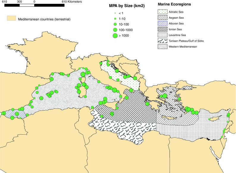
Distribution of MPAs by size (km2) in different ecoregions (Spalding et al. 2007). (Note: only littoral countries are shown)
Twenty-two countries in the Mediterranean basin have a marine presence. Bosnia Herzegovnia, the Palestinian Authority (Gaza), Egypt and Libya have no MPAs that we could find information on or that fit our definition (see Table 2). Generally most countries have a very small number of MPAs. In fact, seven from among the 19 have only one MPA. Italy has the greatest number of MPAs followed by Spain. Of note is that while Spain has a large number of MPAs, many are small and the area protected is similar to the amount of area protected by Greece. Additionally, Spanish MPAs include a relatively large percentage of terrestrial (33 % of the total) area within them. Morocco and Turkey also have a large percentage of terrestrial area in their MPAs, 60 in number and 56 %, respectively; however, there is only one Moroccan MPA in our review.
Table 2.
Number of MPAs by country. Also provided are the submerged (marine) areas within the MPAs in each country, terrestrial areas within the MPAs, their protection levels and their jurisdictional locations by country. “Percentage terrestrial” refers to the ratio of terrestrial to submerged marine area with the MPAs by country
| Country | Total no. of MPAs | Marine vs. terrestrial area coverage | Protection level | EEZa | |||||
|---|---|---|---|---|---|---|---|---|---|
| Submerged area | Terrestrial area | Percentage terrestrial | Limited-take (LT) | No-take | Mixed-use (MU) | LT | MU | ||
| Albania | 1 | 0.1 | 1 | ||||||
| Algeria | 1 | 27.0 | 0.4 | 1.5 | 1 | ||||
| Croatia | 7 | 458.1 | 166.2 | 36.3 | 2 | 5 | |||
| Cyprus | 1 | 5.5 | 1.0 | 18.2 | 1 | ||||
| France | 11 | 964.7 | 84.1 | 8.7 | 1 | 2 | 8 | ||
| Greece | 3 | 2139.2 | 81.0 | 3.8 | 1 | 2 | |||
| Israel | 6 | 19.7 | 0.4 | 2.0 | 5 | 1 | 0 | ||
| Italy | 34 | 10235.2 | 458.7 | 4.5 | 4 | 1 | 29 | 3 | |
| Lebanon | 1 | 4.0 | 0.3 | 7.5 | 1 | ||||
| Malta | 5 | 190.6 | 0 | 4 | 1 | ||||
| Monaco | 2 | 0.5 | 0 | 2 | |||||
| Montenegro | 1 | 26.0 | 94.0 | 361.5 | 1 | ||||
| Morocco | 1 | 196.0 | 290.0 | 148.0 | 1 | ||||
| Slovenia | 3 | 1.3 | 0.5 | 38.5 | 1 | 1 | 1 | ||
| Spain | 26 | 1444.2 | 696.6 | 48.2 | 11 | 15 | 1 | 1 | |
| Syria | 3 | 50.0 | 0 | 1 | 2 | ||||
| Tunisia | 2 | 51.5 | 18.5 | 35.9 | 2 | ||||
| Turkey | 7 | 1709.4 | 2169.0 | 126.9 | 5 | 2 | |||
| UK | 1 | 0.4 | 0 | 1 | |||||
| Italy/France/Monaco | 1 | 87500.0 | 0 | 1 | 1 | ||||
| Total | 117 | 105023.4 | 4060.7 | 3.9 | 40 | 8 | 69 | 2 | 4 |
aBeyond 12 nm territorial sea of each country; the EEZ is generally 200 nm from each countries’ coastline. None of the six MPAs past the territorial limits were no-take reserves
Only 6 MPAs (5.2 %) are beyond their managing countries’ territorial sea, however, because the large Pelagos Sanctuary is located beyond the territorial sea, 80 % of the area within MPAs exists beyond the 12 nm limit in the EEZ. Without it, only 440.52 km2 (0.4 %) of protected marine area is located beyond their respective countries’ territorial sea.
Bathymetric depth largely reflects distance from shore and the jurisdictional status. MPAs that are located in countries’ territorial waters and close to shore, many with terrestrial portions within, tend to be in relatively shallow waters. Although the maximal depth of one MPA reaches −2760 m (see Table 3), only two have depths greater than 2000 m and five have depths greater 1000 m. Although distances vary by ecoregion MPAs are generally close to shore. The many islands and archipelagos make distance from shore difficult to measure and open to interpretation (see the footnote in Table 3). Distance between MPAs also varies greatly between ecoregions, but generally most (96.5 %) have neighbors ≤150 km away (Table 3).
Table 3.
Characteristic of Mediterranean MPAs and human impacts levels within them
| Maximal | Mean | SD | |
|---|---|---|---|
| Depth | −2760 | −216.44 | 426.24 |
| Distancea,b from shore (km2) | 239.85 | 23.92 | 55.63 |
| Distancea to nearest MPA (km2) | 309.23 | 53.36 | 51.95 |
| Human impact (Ic) scores of MPAs | 70 | 39.9 | 12.72 |
The latter is the distance to the next closest MPA. For the depth and distances, minimal measures are close to zero (0 ≤ 1.3)
aCentroids were used for these measurements
bThe shoreline is of the continent or islands ≥9500 km2
The combined impact/activity layer shows greater values in the terrestrial environment than in the marine environment. These values can be best understood in relation to each other. Decision-makers should consider any cells (or cluster of cells) with values above 30 in the marine as a relatively highly impacted are. Likewise, in the terrestrial areas, any cells with values greater than 75 are highly impacted areas.
Only 1 % of the values in cells of the marine layer are above 30 whilst 29 % of the terrestrial layer cells are above this value. The smoothing process conducted to generate values at the land–sea interface produced relatively high values, especially around the Greek and Italian islands located in close proximity to one another. When looking at the marine layer alone, relatively high impact areas (> 20 rescaled Ic) are noted between Italy and the Tunisian Gulf of Sidra (Tunisian Plateau), in the Adriatic Sea, off the coast of Egypt near the Nile River Delta and along the western Turkish coast. Concentrations of high impact areas (>75 rescaled Ic) are found along the north eastern coast of Spain (near Barcelona), France (Gulf of Lion near Marseille and the French Riviera), northern Tunisia (Gulf of Tunis near Ben Arous), and in the Tyrrhenian Sea near the Naples and Amalfi area of Italy.
Average human impacts scores for areas within MPAs are 5 ≥ Ic ≤ 70 (Table 3). An analysis by ecoregions reveals that there is some overlap between areas of relatively high impact and MPAs. There is overlap in the Western Mediterranean ecoregion (especially on the southern side where there are few MPAs to begin with) but not in the Ionian Sea off the coast of Tunisia and Libya where there are no MPAs yet clusters of high impact along the coast (see Fig. 4). In the Levantine Sea there are MPAs near relatively high impact near-shore areas in the eastern part of the ecoregion (Syria/Israel) but not in the southern part (Egypt). In the Aegean Sea, MPAs are generally not near marine human impact hotspots, of high levels. MPAs are distanced from high human impact areas of the sea in the Adriatic Sea. They are located mostly on the northern shore of the sea and not on the southern (Italian side) where impacts are greater, except for several MPAs clustered near a high impact marine area along the Slovenian coast.
Fig. 4.
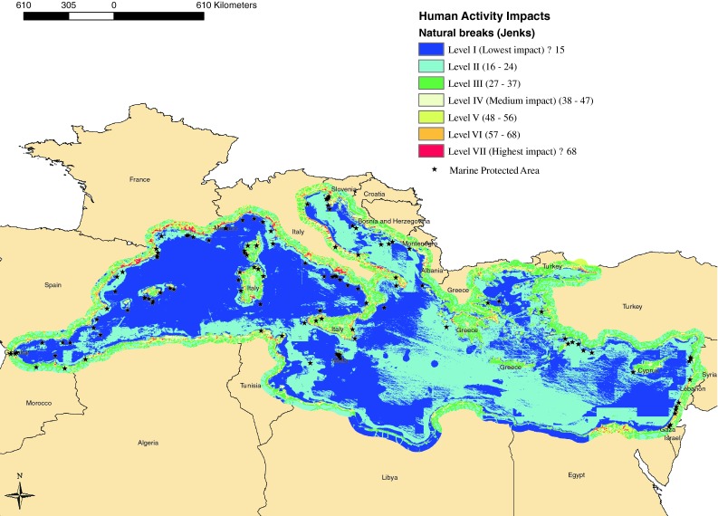
MPAs (black stars) overlayed on marine and terrestrial human impact scores data layer. Rescaled scores are classified into seven categories for visual identification at a regional scale ranging from lowest impact (Ic ≤ 15) to highest impact (Ic ≥ 68). The terrestrial layer extends 50 km inland from the country shoreline boundary (Note: only littoral countries are shown)
Discussion
Literature on MPA design and management highlights the importance of: (1) connectivity when reserves are small and representation among eco-regions (Adulla et al. 2008; Guarderas et al. 2008; Gaines et al. 2010); (2) suitable management regimes (e.g., Friedlander et al. 2003; Vella et al. 2009; Olsen et al. 2011); and (3) MPA distribution vis-á-vis areas of cumulative impacts (e.g., Planes et al. 2000; Coll et al. 2011). The first issue assumes principles of biological conservation, especially for the marine environment (Gaines et al. 2010). The second relates to viable mechanisms of governance within and among MPAs. Regarding the third point, we seek to determine whether MPA managers adopt conservation goals and objectives that depend on either avoiding or seeking out areas of high human impact levels. In the remainder of this paper, we summarize our review of the status and trends in characteristics of MPAs, expand on our analysis of how MPA spatial distribution compares to areas of human impact, relate our approach to current debates on marine protection, and discuss limitations.
Our study shows that there are no true deep-sea Mediterranean MPAs. This is unfortunate since the pelagic, deeper waters of the Mediterranean host endemic species, unique and extremely vulnerable habitats serving charismatic endangered marine species, such as cetaceans (e.g., Canese et al. 2006). The distance between MPAs in the Mediterranean is great when compared to distances between MPAs in other regions of the globe (see Guarderas et al. 2008; Weeks et al. 2010), especially considering the small size and enclosed nature of the Mediterranean. It is difficult to examine distance from shore comparatively because of the lack of studies examining this characteristic.
Almost a decade ago over 30 % of the MPAs existing worldwide consisted of the two categories V and VI (Chape et al. 2003; Mackelworth et al. 2008). Today, in the Mediterranean the most common category is IV. As mentioned, only two MPAs fall under the highest level of protection (Ia) within which any removal of marine species and modification, extraction or collection of marine resources is prohibited. None are listed as type Ib (sites of “relatively undisturbed seascape”). The fact that there are no MPAs of this category may indicate a reluctance to manage this type of reserve in the Mediterranean context. In any case, the cause of this lack requires further research.
The disparity between area protected among the seven ecoregions (Fig. 2a–c) and the 22 Mediterranean countries reinforces the need for a regional, integrative approach to designing and managing MPAs perhaps best achieved through international initiatives similar to those of the EU Marine Framework Directive, Natura2000, or OSPAR efforts in the North Atlantic (Davis 2009). Half of all the MPAs in the Mediterranean have some type of international recognition but internationally recognized protection accounts for only 15 685 km2 (about 14 % of the total protected area) without the large Pelagos Sanctuary.
Generally, the relatively high terrestrial impact levels we found reinforce two points. Firstly, human impacts likely reflect the intensity of use at the meeting of land and sea. Secondly, high impact levels at the marine–terrestrial interface reaffirm the need to use scores along the terrestrial coast when overlaying human impacts and MPA distribution since most MPAs are close to the shore and many include land area. Certainly, human impacts in near-shore areas (submerged and terrestrial) are important because of land-based marine pollution and the density of human activities within coastal watersheds.
The establishment of MPAs in high impact areas of the coast may reflect greater attention given to these areas. In most MPAs, regulations allow recreational activity such as boating or scuba diving, which require surrounding infrastructure (e.g., access roads and tourism facilities). However, for the purposes of marine conservation, pristine areas void of human impacts may be desired.
The limitations of our study highlight what needs more attention in base research that supports planning and policy development for MPAs. The use of secondary data (i.e., collected from various existing databases and not directly collected by the researchers) about existing governance conditions is problematic for two main reasons. Firstly because there is ambiguity concerning what is an MPA and secondly due to discrepancies between what is reported and what actually exists ‘on-the-ground’. There are also temporal and spatial challenges. An MPA existing one year may be done away with the next or reduced or expanded in size.
What constitutes an MPA is a subject not sufficiently dealt with by most past inventories of MPAs in the Mediterranean (Abdulla et al. 2008; Coll et al. 2011) or in other parts of the world (e.g., Guarderas et al. 2008; Weeks et al. 2010), yet it is fundamental for assessing the extent of protection in order to improve on it.1 Variability in definitions impedes assessment of large-scale networks as each country, or region, focuses on varied landscape types and a variety of goals and purposes for their MPAs (Gaines et al. 2010).
The justification for the use of the definition we adopted that determined which MPAs are included in our study is based on: (1) capturing non-terrestrial (true-marine) PAs, and (2) analyzing sites that overlay areas of human impact modeled by Halpern et al. (2008). Further, for the sake of consistency, we excluded areas beyond the base shoreline (usually the mean high water mark) that constitutes the landward limit of each country’s territorial sea although one could argue that areas such as estuaries and coastal wetlands, or terrestrial islands with no submerged areas impact the marine environment. On the other hand, we included shoreline PAs encompassing submerged (subtidal) areas, even those that had greater terrestrial or intertidal area than submerged area. In any case, exact definitions of what is an MPA for the purpose of large-scale networks analysis is a point requiring further clarification and standardization of definition for analyses such as these.
In regards to the second major limitation related to the use of secondary data, we found that upon contacting some MPA managers that some MPAs are “paper parks”, i.e., areas protected on paper or plans, having little or no effect on the ground. Further, by confirming information used in our study by more than one source, we discovered some contradicting data. Our attempts to verify data, led to the discovery of spatial and temporal issues, for example, changes made over time to levels of protections, seasonal closures or boundary expansions or reductions since reports were submitted to the databases.
These discrepancies may hinder future planning for international or regional MPA networks. They can only be avoided by contacting managers of each MPA and ideally several user-groups that could confirm that prohibitions and restrictions are actually enforced and effective. Important information could be gleaned from a focus on such discrepancies, especially for improving MPA networks through adaptive governance within the framework of MSP. Understanding the past and current performance of the governance system, (i.e., the ‘governance baseline’) as it has responded—or failed to respond—to the condition of ecosystems and marine conservation is a recommended first step in an MSP process (Olsen et al. 2011).
Discrepancies between the terrestrial and marine anthropogenic models likely influenced our results. While we did standardize the two data layers before combining them, Sanderson’s focuses more on measures of human activity whereas Halpern et al. (2008) incorporated expert opinion for some of the input used in the marine model which provides information on response variables. A single layer, representing human impacts to both terrestrial and marine environments using the same assessment method would be optimal.
Finally, our taxonomy is limited to data available and to information that could be arrived at through spatial calculations conducted by the GIS software. Some assumptions were made in these calculations. For example, we calculated distance from shore to major land bodies and not to the many islands existing with the Mediterranean Sea. Some of our categories were adopted from previous studies, for example, the three levels of protection (no-take, mixed-take, and limited-take) used by Guarderas et al. (2008) and the eco-regions of Spalding et al. (2007) used by both Abdulla et al. (2008) and Halpern et al. (2008). In this way, our study could lead to cross-study comparisons and some level of standardization.
Despite discrepancies in the data, our study identifies great variability between countries and eco-regions in terms of protection levels and numbers and sizes of MPAs. Mediterranean countries have yet to address gaps and inconsistencies. The size of the sea and the close proximity of many countries with a history of conflict between them and a lack of environmental awareness among the general populace (Laubier 2005), does not lend itself to optimal size and spacing of reserves using parameters such as those proposed by Gaines et al. (2010). New ideas of mobile MPAs that follow the life cycle of protected species such as sea turtles or endangered marine mammals or those that would move according to environmental influences such as climate change (e.g., Amos 2012), require expensive and complex technology as well as highly developed, well-coordinated governance regimes. In the near future, it is unlikely that these types of networks or MPAs could be fully implemented in the Mediterranean where there are already great challenges for the implementation of static reserves.
The comparing of existing MPAs to levels of impacts on land and sea gives an initial understanding of what has been taken into account and whether planners have sought or avoided impacted and high anthropogenic activity areas in each region. The desirability of these trends requires further comparison to specific MPA goals and objectives.
Conclusions
Conditions in the Mediterranean basin on the one hand facilitate a coordinated multinational approach to marine conservation, i.e., the physical proximity of countries, recent international commitments to MSP efforts (Olsen et al. 2011) and the fact that the Mediterranean Sea is well-studied (Abdulla et al. 2009). But there are difficulties in the Mediterranean including political instabilities within countries and conflict among them. Radically different western and Middle Eastern cultures meet here. In any case, development aspects of human systems should be part of a PA planning and spatial planning. Planning for MPA networks needs to include spatial distribution analysis that considers the terrestrial–marine human impact levels in the coastal zone.
MPA planners and policymakers must make decisions that balance protection of both disturbed and undisturbed marine environments. Some MPAs should be designated to halt degradation in high impact areas and for rehabilitation and others should be distanced from such areas to provide the best conditions for preservation. The likelihood of MPA acceptance and support of the local community and user-attractiveness also needs to be considered. Such considerations may support designation of MPAs in areas of high human impact, close to developed infrastructure and where jobs related to the MPA milieu can be created. These mixed approaches highlight the need for network planning on an international scale especially considering the small size of most Mediterranean MPAs.
In conclusion, we show that both marine and terrestrial information on human impacts and activities can be combined to inform about gaps in protection. We analyzed for the first time how areas with MPAs overlap with areas that suffer high anthropogenic threats in both the marine and terrestrial (coastal) areas of the Mediterranean Sea. Current MPAs are generally not in the highest impact areas or in areas with greatest human activity, but few MPAs are distanced from shore in deep waters farther from shore in areas with lowest impacts. Because MPAs are generally close to shore they are closer to high impact areas than they would be if they were farther out at sea. Decision-makers wishing to design and establish new MPAs may seek out areas of high human impacts (near the marine–terrestrial interface) or avoid them depending on marine conservation objectives and the regional perspective for a variety of MPAs within a network.
Acknowledgments
The authors gratefully acknowledge the support of the Marie Curie International Reintegration Grant Program for funding this research through the Designation and Management of Marine Reserve Networks project (European Commission, FP7, Grant 268115). Also, we thank MPA managers for information on MPAs in their respective countries: Marko Pećarević (Croatia), Ruti Yahel (Israel), Patrick Schembri, Darrin Stevens and Christopher Cousin (Malta), Novak Cadjenovic (Montenegro), Leonardo Tunesi (Italy), Marta García Pérez (Spain).
Biographies
Portman
is an Assistant Professor at the Technion - Israel Institute of Technology in Haifa, Israel. Her research interests include environmental planning, spatial analysis, coastal and marine resource management.
Daniel Nathan
is a Master’s student in the Department of Geography at the Hebrew University of Jerusalem, Israel. His interests include environmental planning and management.
Noam Levin
is a Senior Lecturer in the Department of Geography at the Hebrew University of Jerusalem, Israel. His research interests include spatial analysis for conservation and GIS.
Footnotes
Due to the variability of MPA definitions inventories of MPAs in the Mediterranean as in the world over are highly variable. Abdulla et al. (2009) recognizes a total of 94 MPAs while a recent publication of the IUCN (Anonymous 2011) describes 750 Specially Protected Areas in the Mediterranean of which “two-thirds are marine protected areas covering approximately 97 000 km2 or roughly 4 % of the marine environment”.
Contributor Information
Michelle E. Portman, Email: michellep@ar.technion.ac.il, http://portman.net.technion.ac.il/
Daniel Nathan, Email: daniel.nathan@mail.huji.ac.il.
Noam Levin, Email: noamlevin@mscc.huji.ac.il.
References
- Abdulla, A., M. Gomei, E. Maison, and C. Piante. 2008. Status of marine protected areas in the Mediterranean Sea. Malaga, Spain; Paris, France: IUCN; WWF.
- Abdulla A, Gomei M, Hyrenbach D, Notarbartolo-di-Sciara G, Agardy T. Challenges facing a network of representative marine protected areas in the Mediterranean. ICES Journal of Marine Science. 2009;66:22–28. doi: 10.1093/icesjms/fsn164. [DOI] [Google Scholar]
- Agardy T. Information needs for marine protected areas: Scientific and societal. Bulletin of Marine Science. 2000;66:875–888. [Google Scholar]
- Amos, J. 2012. ‘Mobile marine reserves’ needed. BBC News. Retrieved 22 Feb 2012, from http://www.bbc.co.uk/news/science-environment-17070993.
- Anonymous. 2011. Mediterranean Sea: Better management for more biodiversity. Marine News - IUCN Global Marine and Polar Programme Newsletter 2010–2011 8: 16–17.
- Bianchi CN, Morri C. Marine biodiversity of the Mediterranean Sea: Situation, problems and prospects for future research. Marine Pollution Bulletin. 2000;40:367–376. doi: 10.1016/S0025-326X(00)00027-8. [DOI] [Google Scholar]
- Bishop, K., N. Dudley, A. Phillips, and S. Stolton. 2004. Speaking a common language: The uses and performance of the IUCN system of management categories for protected areas. Cambridge: Cardiff University, IUCN.
- British Oceanographic Data Centre. 2011. General Bathymetric Chart of the Ocean (Gridded Bathymetry data). Retrieved 11 Feb 2011, from https://www.bodc.ac.uk/data/online_delivery/gebco/.
- Broquere, M. 2005. How many marine protected areas exist in the West Mediterranean? Gland, Switzerland: IUCN Center for Mediterranean Cooperation.
- Canese S, Cardinali A, Fortuna CM, Giusti M, Lauriano G, Salvati E, Greco S. The first identified winter feeding ground of fin whales (Balaenoptera physalus) in the Mediterranean Sea. Journal of the Marine Biological Association of the UK. 2006;86:1–5. doi: 10.1017/S0025315406013853. [DOI] [Google Scholar]
- Chape, S., S. Blyth, L. Fish, P. Fox, and M. Spalding. 2003. 2003 United Nations list of protected areas. Gland, Switzerland; Cambridge: IUCN; UNEP.
- Coll M, Piroddi C, Albouy C, Lasram FBR, Cheung WWL, Christensen V, Karpouzi VS, Guilhaumon F, et al. The Mediterranean Sea under siege: spatial overlap between marine biodiversity, cumulative threats and marine reserves. Global Ecology and Biogeography. 2011;20:1–16. doi: 10.1111/j.1466-8238.2010.00578.x. [DOI] [Google Scholar]
- Davis JE. Re-examining the role of MPAs in ecosystem-based management. MPA News. 2009;10:1–3. [Google Scholar]
- Dudley N, editor. Guidelines for applying protected area management categories. Gland, Switzerland: IUCN, World Conservation Union; 2008. [Google Scholar]
- Friedlander A, Sladek Nowlis J, Sanchez JA, Appeldoorn R, Usseglio P, McCormick C, Bejarano S, Mitchell-Chui A. Designing effective marine protected areas in Seaflower Biosphere Reserve, Colombia, based on biological and sociological information. Conservation Biology. 2003;17:1769–1784. doi: 10.1111/j.1523-1739.2003.00338.x. [DOI] [Google Scholar]
- Gaines SD, White C, Carr MH, Palumbi SR. Designing marine reserve networks for both conservation and fisheries management. Proceedings of the National Academy of Sciences. 2010;107:18286–18293. doi: 10.1073/pnas.0906473107. [DOI] [PMC free article] [PubMed] [Google Scholar]
- Guarderas AP, Hackerm SD, Lubchenco J. Current status of marine protected areas in Latin America and the Caribbean. Conservation Biology. 2008;22:1630–1640. doi: 10.1111/j.1523-1739.2008.01023.x. [DOI] [PubMed] [Google Scholar]
- Halpern BS, Walbridge S, Selkoe KA, Kappel CV, Micheli F, D’Agrosa C, Bruno JF, Casey KS, et al. A global map of human impact on marine ecosystems. Science. 2008;319:948–952. doi: 10.1126/science.1149345. [DOI] [PubMed] [Google Scholar]
- Halpern BS, Warner RR. Matching marine reserve design to reserve objectives. Proceedings of the Royal Society of London Series B-Biological Sciences. 2003;270:1871–1878. doi: 10.1098/rspb.2003.2405. [DOI] [PMC free article] [PubMed] [Google Scholar]
- Hassan R, Scholes R, Ash N, editors. Millennium Ecosystem Assessment 2005. Washington, DC: Island Press; 2005. [Google Scholar]
- Hinrichsen D. Coastal waters of the world: Trends, threats, and strategies. Washington, DC: Island Press; 1998. [Google Scholar]
- Jennings MD. Gap analysis: Concepts, methods, and recent results. Landscape Ecology. 2000;15:5–20. doi: 10.1023/A:1008184408300. [DOI] [Google Scholar]
- Laubier L. Mediterranean Sea and humans: Improving a conflictual partnership. In: Saliot A, editor. The handbook of environmental chemistry. Berlin: Springer; 2005. pp. 3–28. [Google Scholar]
- López-Ornat, A., A. Pons-Reynés, and M. Noguera. 2007. Use of IUCN protected area management categories in the Mediterranean region. Gland, Switzerland; Sevilla, Spain and Malaga, Spain: IUCN and Consejería de Medio Ambient of Junta de Andalucía.
- Lubchenco J, Sutley N. Proposed U.S. policy for ocean, coast, and Great Lakes stewardship. Science. 2010;328:1485–1486. doi: 10.1126/science.1190041. [DOI] [PubMed] [Google Scholar]
- Mackelworth, P., D. Halcer and C. Fortuna. 2008. Multiple use marine protected areas as complex commons. The 12th Biennial Conference of the International Association for the Study of Commons, Cheltenham, England, University of Gloucestershire.
- Maiorano L, Bartolino V, Collaca F, Abella A, Belluscio A, Carpentieri P, Criscoli A, Lasin GJ, et al. Systematic conservation planning in the Mediterranean: A flexible tool for the identification of no-take marine protected areas. ICES Journal of Marine Science. 2009;66:137–146. doi: 10.1093/icesjms/fsn148. [DOI] [Google Scholar]
- MedPan. 2010. How to support the development of alternative livelihoods and/or income-generating activities in the Mediterranean Marine Protected Areas? MedPAN Network Regional Experiance Sharing Workshop Proceedings of December 12–14, 2010. Korba, Tunisia, MedPAN Network.
- Myers N, Mittermeier RA, Mittermeier CG, da Fonseca GAB, Kent J. Biodiversity hotspots for conservation priorities. Nature. 2000;403:853–858. doi: 10.1038/35002501. [DOI] [PubMed] [Google Scholar]
- NCEAS. 2008. A global map of human impacts to marine ecosystems. Retrieved 10 March 2011, from http://www.nceas.ucsb.edu/globalmarine/impacts.
- NOAA. 2011. State coastal zone boundaries. Retrieved 31 July 2011, from http://coastalmanagement.noaa.gov/mystate/docs.
- Olsen S, Olsen E, Schaefer N. Governance baselines as a basis for adaptive marine spatial planning. Journal of Coastal Conservation. 2011;15:313–322. doi: 10.1007/s11852-011-0151-6. [DOI] [Google Scholar]
- Planes S, Galzin R, Garcia Rubies A, Goni R, Harmelin J-G, Direach LLE, Lenfant P, Quetglas A, et al. Effects of marine protected areas on recruitment processes with special reference to Mediterranean littoral ecosystems. Environmental Conservation. 2000;27:126–143. doi: 10.1017/S0376892900000175. [DOI] [Google Scholar]
- Exploring the Potential of Marine Spatial Planning in the Mediterranean Sea. Brussels: Directorate-General for Maritime Affairs and Fisheries of the European Commission; 2011. [Google Scholar]
- Portman ME, Fishhendler I. Towards integrated coastal zone management: Approaches and tools. Jerusalem, Israel: Hebrew University; 2011. [Google Scholar]
- Rogers, A. D., and D. d’A. Laffoley. 2011. International Earth system expert workshop on ocean stresses and impacts. Summary report. International Program on the State of the Ocean, IPSO, Oxford.
- Sanderson EW, Jaiteh M, Levy MA, Redford KH, Wannebo AV, Woolmer G. The human footprint and the last of the wild. BioScience. 2002;52:891–904. doi: 10.1641/0006-3568(2002)052[0891:THFATL]2.0.CO;2. [DOI] [Google Scholar]
- Spalding MD, Fox HE, Allen GR, Davidson N, Ferdaña ZA, Finlayson M, Halpern BS, Jorge MA, et al. Marine ecoregions of the world: A bioregionalization of coastal and shelf areas. BioScience. 2007;57:573–583. doi: 10.1641/B570707. [DOI] [Google Scholar]
- Vella P, Bowen RE, Frankic A. An evolving protocol to identify key stakeholder-influenced indicators of coastal change: the case of marine protected areas. ICES Journal of Marine Science. 2009;66:203–213. doi: 10.1093/icesjms/fsn183. [DOI] [Google Scholar]
- VLIZ. 2009. Maritime boundaries Geodatabase (Version 5). Retrieved 9 Feb 2011, from http://www.vliz.be/vmdcdata/marbound.
- WCS. 2011. The last of the wild version two. Retrieved 20 June 2011, from http://www.ciesin.columbia.edu/wild_areas/.
- Weeks R, Russ GR, Alcala AC, White AT. Effectiveness of marine protected areas in the Philippines for biodiversity conservation. Conservation Biology. 2010;24:531–540. doi: 10.1111/j.1523-1739.2009.01340.x. [DOI] [PubMed] [Google Scholar]
- Wood, L. J. 2007. MPA global: A database of the world’s marine protected areas. Sea Around Us Project, UNEP-WCMC and WWF. Retrieved 11 Sept 2011, from http://www.mpaglobal.org/home.html.