

Abstract
We analyze 4000-year flood history of the lower Yellow River and the history of agricultural development in the middle river by investigating historical writings and quantitative time series data of environmental changes in the river basin. Flood dynamics are characterized by positive feedback loops, critical thresholds of natural processes, and abrupt transitions caused by socio-economic factors. Technological and organizational innovations were dominant driving forces of the flood history. The popularization of iron plows and embankment of the lower river in the 4th century bc initiated a positive feedback loop on levee breaches. The strength of the feedback loop was enhanced by farming of coarse-sediment producing areas, steep hillslope cultivation, and a new river management paradigm, and finally pushed the flood frequency to its climax in the seventeenth century. The co-evolution of river dynamics and Chinese society is remarkable, especially farming and soil erosion in the middle river, and central authority and river management in the lower river.
Keywords: Co-evolution, Flood history, Human activities, Positive feedback loop, Yellow River
Introduction
The Yellow River is China’s “mother river,” feeding a 4000-year-old Chinese civilization. During the last two millennia the river has proved to be violent. The flash floods carry enormous amounts of silt generated from thousands of gullies downstream, resulting in highly perched floodplain channels with levees that often failed, devastating villages and cities and their people.
Kaifeng located at the apex of the Yellow alluvial fan has been at the epicenter of the Yellow River flooding (Fig. 1). Since the 4th century bc seven floods have devastated the city. After each flood survivors rebuilt a new city on the same site. Six Kaifeng cities now lie buried under silt with the oldest “fossil” city buried 10-m underground (Qiu 2004).
Fig. 1.

Topographical view based on Shuttle Radar Topography Mission 90-m resolution data showing the locations and frequencies of flood events in the lower Yellow River in historical times. Statistics derived from records in The Chronicle of the Yellow River (Shen et al. 1935) and The Chronicle of Events of the Yellow River (Yellow River Conservancy Commission 2001). The number of floods at each location combine all historical records of “overspill,” “breach,” “avulsion,” “flood,” and “river breached” for different channels in their active periods. The prefecture of Kaifeng was struck by most disasters; 84 floods. Colors of the symbols correspond to the five distinguished periods in the section “History of the Yellow River Floods”
Historical documents document >1000 floods occurring in 4000 years. In the last millennium, the river has shifted its lower course every ~25 years (Fig. 2), breached its levees once a year, and during the mid seventeenth century the breach frequency was as high as three times a year on average (Fig. 3a). The super-elevation of its channel bed has contributed to the width of the levee breaches, making levee repair an arduous, costly job. The levee breach at Zhengzhou in 1887 had a width of 1650 m, and the total cost of its closure was 12 million taels, ~15 % of the annual national revenue at the time.
Fig. 2.

Changes in the course of the lower Yellow River in historical times. The channel belts are traced from SRTM data in combination with Historical Atlas of China (Tan 1982). 1 Shanjing River, 2 Yugong River, 3 Hanzhi River, 4 Eastern Han River, 5 Northern Course, 6 Eastern Course, 7 Old Yellow River, 8 Present-day Yellow River. Colors correspond with distinguished period, and the thickness of lines indicates the period of the river course existence, not the width of the channel belt
Fig. 3.
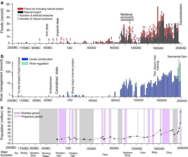
a, b Time series of the numbers of floods and river management activities in the lower Yellow River for 2500 bc–2000 ad. Statistics are based on records in The Chronicle of the Yellow River (Shen et al. 1935) and The Chronicle of Events of the Yellow River (Yellow River Conservancy Commission 2001). The number of floods at each location combine all historical records of “overspill,” “breach,” “avulsion,” “flood,” and “river breached” for different channels in their active periods. River management activities sum the historical records of “construction” and “regulation”. c Changes in population of the middle Yellow River and the shifts of warfare and prosperous periods in the Chinese society for 2500 bc–2000 ad. Population counts before 1953 are farming populations estimated on the basis of historical household registration data, and thus underestimate actual population (Yang 1993; Ge et al. 2002)
Here, we present the flood history of the lower Yellow and the history of agricultural development in the middle river, by investigating written historical accounts. We analyze the driving forces of flood frequency, using quantitative time series data of environmental changes in the river basin. We investigate how Yellow River flooding has influenced Chinese society throughout its imperial period, and how in turn human factors have impacted frequent flood events in the later imperial period.
Study Area
The Yellow River originates in the Qinghai-Tibet Plateau, flows 5464 km through the northern China and presently empties into the Bohai Sea, draining an area of 0.75 million km2. The Loess Plateau in the middle river region comprises 0.28 million km2 with depths of loess >100 m. The alluvial plains of 800-km long lower Yellow cover an area of 0.25 million km2. Over historical times, the river has swept over the entire alluvial plain, discharging into both the Bohai Sea and the Yellow Sea (Fig. 2). From the 21st century bc to the 12th century ad, the middle and lower Yellow River flowed through the most developed region of China, and all unified dynasties had their capitals in this region. Today, the river supplies water to 12 % of the population and 15 % of China’s cropland.
Between 1920 and 1960, mean annual precipitation in the Yellow basin was 480 mm, producing a runoff of 58 × 109 m3. The annual average sediment load was 1.6 × 10⁹ t, with an average sediment concentration of 38 kg m−3. Due to super-elevation of the channel belt, the contributing area of the lower basin is only 23 000 km2 with flow along the lower reach depending on water and sediment supply from the upper and middle basins. Water and sediment supplied by the middle basin contribute, respectively, 50 and 88 % of the total discharges at Huayuankou which is the entrance of the lower river (Fig. 4). As the middle Yellow River basin is situated in the fringes of the area affected by the East Asia Summer Monsoon, it suffers from frequent storms and its annual precipitation is very sensitive to monsoonal shifts (Ye et al. 1956). Therefore, its water and sediment discharge variabilities are large. Modern hydrologic observation data at the Huayuankou station show that the largest record flood occurred in 1958 with a peak discharge of 22 300 m3 s−1 and a maximum sediment concentration of 911 kg m−3, 14× and 24× their mean annual values, respectively (Yellow River Conservancy Commission 1998).
Fig. 4.

The geography of the study area, showing the Yellow River and tributaries. Important features in the drainage basin are illustrated; the extend of the river basin (gray shade), the location of the Loess Plateau, the position of the Great Wall, the boundary between the forest and steppe ecotones and the two canals
Loess can be easily transported, thus >90 % sediment produced in the middle basin can be delivered to the lower river (Walling 1999). Soil erosion and sediment yield increase across the Loess Plateau from southeast to northwest (Xu and Cheng 2002; Hassan et al. 2008), where surface lithology gradually changes from clayey loess to sandy loess. Sediment coarser than 0.05 mm dominates channel sedimentation in the lower Yellow. Sediment yields can exceed 5000 t km−2 y−1 with coarse sediment yields >1300 t km−2 y−1 (Xu et al. 2000). Coarse-sediment producing areas (CSA) occupy ~70 000 km2 of the middle Yellow basin, a gully-rich region close to the northern boundary of forest-steppe ecotone (Fig. 5). CSA is a critical zone that supplies most of the sediments that can be deposited in the lower channel (Xu and Cheng 2002; Xu et al. 2009).
Fig. 5.

Changes of the northern boundary of the farming-grazing transitional zone over 1500 bc–2000 ad (modified after Zhang 1996). For 3500 years, the boundary has moved 300–400 km in the northwest direction. After the thirteenth century, the boundary permanently crossed most area of the coarse-sediment producing area (CSA) of the Loess Plateau. The present-day land-use boundary is 150- to 200-km north of the northern boundary of the forest-steppe ecotone
The middle Yellow River basin drains the forest-steppe ecotone, an area suitable for farming or grazing. As climate altered, the Chinese and the nomadic people were either at peace or at war. The location of the farming-grazing transitional zone (hereafter FGTZ) shifted northwards or southwards as a result of the power balance between the Chinese and the nomadic people (Fang and Liu 1992) (Fig. 5). And as Chinese population increased and farmlands expanded, the northern boundary of FGTZ pushed further northwards. Especially if CSA was intensively farmed, soil erosion in the middle basin and sedimentation rate in the lower channel would increase substantially (Xu 2001, 2003).
Though there is no quantitative record of sediment loads of the Yellow River through historical times, most researchers note that large variations occurred due to time varying human impacts. Ren and Zhu estimated the “pristine” annual sediment load at 4 ka BP to be 0.17 Bt, 10 % of the 1950 values (Ren and Zhu 1994). In the sixteenth century, the Yellow River had already been described as a river of “60 % silt”.
Due to a cooling and drying trend in climate (Shi et al. 1993; Ge et al. 2003) and continuous deforestation (Shi et al. 1985; Zou 1990; Fang and Xie 1994; Elvin 2004), water yield in the middle Yellow River diminished but its variability increased. According to historical accounts, before the 2nd century ad the middle river and its major tributaries were busy navigation channels (Shi 2001). Nowadays the middle river is not navigable and most tributaries experience seasonal drying. The hydraulic engineer Wan Gong of the Ming Dynasty wrote in Means for the Yellow River Control (治水筌蹄, 1570 ad), “Every year there are at most five or six floods… floods are rapid and large. Flood stage fluctuates unpredictably”. Wan Gong thus provides evidence that runoff of the lower river was highly variable since at least the late sixteenth century.
Embankment is another reason for changes in water discharge during historical era. Before 350 bc when the lower river had not been completely harnessed, most rivers in the North China plains fed the river. After the embankment the lower river turned into a perched channel, with its water discharge relying solely on water supply from the middle and upper basins.
Materials and Methods
China possesses a remarkably continuous written history providing information on natural and anthropogenic environmental changes, such as floods, droughts, agricultural activities, irrigation, river management, extreme climate, geography, territory, population, and economic activities allowing detailed reconstructions of river evolution. In the following, we present reconstruction methods of the historical data.
Time series of the numbers of flood events and river management activities (Fig. 3a, b) and the map of flood locations (Fig. 1) are compiled on the basis of statistics in The Chronicle of the Yellow River (Shen et al. 1935) and The Chronicle of Events of the Yellow River (Yellow River Conservancy Commission 2001). All floods occurred on the lower river, upstream the apex of the delta. The natural flood events are noted in historical documents as “overspill,” “breach,” “avulsion,” and a few times as just “flood”. Artificial breach or artificial avulsion events are noted as “river breached”. River management activities are noted either as “construction” including levee construction, maintenance and repair, or “regulation,” that is, flood prevention measures without using levees, such as damming, diversion, spillway, soil and water conservation, river bureaucracy establishment, and river conservancy. In Figs. 1 and 3, the numbers of floods are the sums of records of “overspill,” “breach,” “avulsion,” “flood,” and “river breached”. The numbers of river management activities are the sums of “construction” and “regulation”.
All records after 841 bc can be accurately dated on annual timescales. During 304 and 439 ad, the lower Yellow River region was occupied by nomadic groups, so there are no flood and river management records during this period. Records greatly increased after the 10th century ad with flood events differentiated as “overspill” or “breach”. 1129–1270 ad was the early stage of the Yellow River’s southern diversion into the Huai River system and there was not yet an embankment system. Thus, there is very few flood records. After the complete embankment of the lower river in 1579, it is very unlikely that any flood event or river management activity was missed. The river channel was unrestrained during 1855–1868 ad following a major avulsion, so the records decreased again. The increase in record precision does contribute to the increase in flood event number across the four millennia. But avulsions since the 2nd century bc were impossible to be missed by ancient Chinese.
The river courses of the lower Yellow in different periods (Fig. 2) trace those in TheHistorical Atlas of China (Tan 1982). They are retrieved from geographical accounts in historical writings and ancient maps, assisted with geophysical investigations on paleochannels and archaeological evidences. The courses before 350s bc are mostly conjectures based on brief historical accounts. The courses in later times are considered accurate.
The pattern of deforestation in the middle river basin is recovered using records on loggings and reclamations, and landscape descriptions in literature over different historical periods (Shi et al. 1985; Zou 1990; Fang and Xie 1994; Elvin 2004). The northern boundaries of FGTZ in different periods (Fig. 5) trace the research results of (Zhang 1996), which are mainly based on China’s northwest territory borders presented in The Historical Atlas of China and the accounts on the distributions of nomadic peoples and economic geography in The Twenty-five Histories (二十五史).
Historical population size in the middle river basin is estimated on the basis of household registration data. Some are estimates on the basis of written accounts on population growth or loss rates during certain period (Yang 1993; Ge et al. 2002). As in the imperial times registered populations were farming populations, the population density can be estimated by dividing the population size by the middle basin area south of the northern boundary of FGTZ. Grain yields in the middle river basin in different dynasties are estimates on the basis of accounts in The Twenty-five Histories (Perkins and Wang 1969; Ning et al. 1999).
The long-term averaged sedimentation rates of the lower river channel in different periods are based on borehole analysis and 14C dating, assisted with the comparison of maps in different times (Xu 1998, 2003).
History of the Yellow River Floods
We divide the history of the Yellow River floods into five periods: before embankment in the 5th century bc, from embankment in the 5th century bc to 70 ad, from 70 ad to 1128 ad, from 1128 ad to 1855 ad, and from 1855 ad to the present day. This division is based on step-wise changes of flood frequency and records every major avulsion cycle of the Yellow River (Table 1).
Table 1.
Changes in natural and human factors of the Yellow River over historical times
| Period | Major dynasties | Socio-economic changes | Middle river | Lower river | |||||
|---|---|---|---|---|---|---|---|---|---|
| Population density (persons per km2) | Area south of the northern boundary of FGTZ (percentage) | Grain yield (kg/ha) | Sedimentation rate (mm/a) | Number of avulsions | Number of breaches | Number of river management activities | |||
| 21st–5th Century bc | Xia, Shang, Western Zhou | Agriculture, state | <38 | 1–2 | 1 | 3 | |||
| 5th Century bc–70 ad | Warring States, Qin, Western Han | Plow, embankment, the Great wall, centralized imperial state, “farming and fight” military policy | <26 | 38–88 | Western Han: 1050 | 2–4 | 5 | 9 | 7 |
| 70 ad–1128 ad | Eastern Han, Tang, Northern Song | Northern Song: steep hillslop cultivation | <36 | 60–97 | Northern Song: 1400–1700 | 2–20 | 12 | 110 | 144 |
| 1128 ad–1855 ad | Ming, Qing | River control paradigm “restrict the current to attack the silt,” river management system | 36–80 | 80–100 | 450–1000 | 20–30 | 40 | 419 | 1018 |
| 1855 ad–the present | Qing, PRC | Damming, industrialization, agricultural modernization | 80–235 | 100 | 1000–3000 | 30–200 | 1 | 96 | 2120 |
Historical population densities in the middle river are estimated by dividing registered population sizes (Fig. 3c) by the middle basin areas south of the northern boundary of FGTZ in different periods (Fig. 5). Grain yields in the middle river are estimates on the basis of accounts in The Twenty-five Histories (Perkins and Wang 1969; Ning et al. 1999). The sedimentation rates of the lower river channel are after Xu (1998, 2003). The number of avulsions is the total number of historical records of natural and artificial avulsions; the number of breaches is the total number of historical records of natural and artificial breaches. The number of the river management activities is the sum of historical records of “construction” and “regulation”
21st–5th Century bc
4000–2000 bc was the mid-Holocene warm and moist period. The northern boundary of forest-steppe ecotone was located 300- to 400-km northwest to the present boundary (Shi et al. 1993) (Fig. 4). As loess is fertile soil that could be easily reclaimed in the Stone Age, the loess region of the middle Yellow River basin became the cradle of Chinese agriculture. At that time the lower Yellow River flowed through wetlands with no traces of human activity (Ho 1969).
2000–1000 bc was a period of cooling and drying (An et al. 2005; Redman et al. 2007). The cooling drove the boundary of forest-steppe ecotone to shift southwards to ~100-km northwest of the present boundary (Shi et al. 1993). The cooling event impelled the separation of grazing and sedentary farming. Hence, the nomadic peoples appeared and occupied the middle and northern parts of the middle basin, while farmers, or the Chinese later, withdrew to the southeast part of the middle basin and kept expanding to the lower river. Thus, establishing the earliest FGTZ (Han 2005) (Fig. 5).
During the 21st century bc to 476 bc, the Chinese established three consecutive dynasties Xia, Shang, and Western Zhou, all centered in the middle and lower Yellow River region. Farming area in the Loess Plateau was small and located in river valleys, on flat loess terraces and on high plains where soil erosion intensity is modest (Ho 1969). The Chinese were still practicing a mixed farming that included pasture, fishing, and hunting. Hence, the intensity and impacts of farming in the middle basin was low (Fang and Xie 1994; Elvin 2004). The Loess Plateau was a land of forests and grasslands with plenty of water and lush vegetation (Shi et al. 1985).
During the 8th to the 5th century bc the lower Yellow River had three major distributaries, the Yugong River, the Hanzhi River, and the Shanjing River (Fig. 2). Except the avulsion event in 602 bc, other flood events are all legends. In the 16th century bc of the Shang Dynasty there were four flood records. Shang moved its capitals five times in the lower Yellow River region. Post-Shang records state that at least one capital was moved following destruction by a catastrophic flood (Rapp and Jing 2011).
5th Century bc–70 ad
Between the 5th century bc and 70 ad were the periods of the Warring States, Qin, and Western Han. The climate in the Yellow River basin was more or less stable, while human’s ability to engineer nature increased significantly as iron tools and cattle plows spread. The Yellow River basin was transformed in four ways: a complete levee system in the lower river came into place in 350 bc. This fixed channel was the Hanzhi River (Fig. 2). Reclamation in the middle river expanded, and agriculture was transformed into pure farming. Irrigation works thrived along the middle and lower rivers. In 215 bc, the first emperor of China, Qin Shi Huang, built the Great Wall geographically close to the northern boundary of forest-steppe ecotone (Fig. 4). In 127 bc, farming advanced in the northwest and the Great Wall became a distinct dividing line between farming and grazing areas (Fig. 5).
The Western Han Dynasty saw the population in the middle basin increase 3 times to 7.9 million. Reclamation, firewood cutting, and constructions of grand palaces resulted in large-scale deforestation. Forests in the southern valleys of middle basin diminished (Shi et al. 1985; Zou 1990). Around 127 bc, 0.6–0.8 million soldiers and civilians migrated to the frontier area along the Great Wall. In 2 ad, the population in the loess hill area increased to 2.8 million. As shown in Fig. 5, this agricultural expansion transformed the CSA into a farming region. The Sanyangzhuang settlement site on the North China plain was recently excavated, it was inundated by a catastrophic levee breach event of the lower river in the late Western Han. Paleoflood deposits indicate that the flood was a muddy flow with a sediment concentration >200 kg m−3 (Lawler 2010).
The Book of Han: The Gazetteer of Channels and Canals (汉书·沟洫志, 83 ad) notes that at that time the distance between the levees on both banks of the lower river was as wide as 25 km. The broad floodplains covered by fertile silts allured people into the levees. Thus, the inner floodplains were cultivated and villages boomed. Large-scale reclamations and irrigation diversions in the middle basin increased sediment inputs and decreased water flow to the lower river, and as a result, siltation of the lower river channel increased. By the middle of the 2nd century bc the lower river had been raised above the surrounding floodplain (Shi 2001).
Floods became more frequent as the Yellow River evolved into a perched river. During 168 bc and 8 ad of the mid-late Western Han, eight levee breaches occurred. People were pleased that fertile muddy floods could be used to restore saline soils, and they acknowledged that the essential principle of river management should be “Don’t contend with flows for lands”. Hence, people were not active in breach closures and thus four of the eight breaches triggered avulsions, resulting in several distributaries. The most well-known breach occurred in 132 bc and was not closed until 109 bc when the Emperor Wu of Han visited the breach site and mobilized tens of thousands of troops for a closure project. In 11 ad, the Yellow River broke the levees again and the supreme commander was against levee closure. Consequently, the Yellow River kept flooding for decades. In 70 ad, the hydraulic engineer Wangjing commanded hundreds of thousands of troops to dig a new channel for the Yellow River, that is, the Eastern Han River (Fig. 2).
70–1128 ad
Between the first and twelfth century there was a drying trend coinciding with several big cold-warm alterations in northern China (Zhang et al. 1994; Ge et al. 2003). The northern boundary of forest and steppe ecotone moved 100-km southeast approaching its present location (Wu et al. 1994). This millennium saw frequent transitions between the Chinese and nomadic states in the Yellow River basin as climate oscillated frequently. The location of FGTZ shifted southward and northward significantly in response (Zhang 1996) (Fig. 5). Between first and fourth century farming population dropped sharply in the middle river because of endless wars between northern nomadic peoples and the Chinese. As a result, the northern boundary of FGTZ withdrew southward to its location before the Great Wall was built, and the grazing dominated the middle basin. In the mid fifth century climate warmed, the Chinese Empires Sui and Tang rose, and as a result the northern boundary of FGTZ moved northward. As the Northern Song Dynasty between the mid tenth and twelfth century was an important period for agricultural exploitation, the proportion of farming in the transitional zone increased substantially and most of the middle basin was transformed into pure farming area.
Before 581 ad thanks to a small farming population, there was no severe soil erosion in the middle basin, and the lower river was quiescent. Historical records show that there were merely ~30 flood events of which most were “overspill” events causing little harm. During the periods of Sui, Tang, and Five Dynasties (581–960 ad), the farming population in the middle basin recovered and exceeded that of the Western Han Dynasty. Numerous trees in the middle basin were cut down for farming, settlement, fuel, and the construction of palaces and temples. Grasslands in the middle basin were well preserved as ranches until the mid Tang Dynasty, owning to the exceptionally prosperous horse administration in that period. As the Tang Empire declined after the An-Shi Rebellion (755–763 ad), so did these ranches. During the late Tang and Five Dynasties, as the annexation of land intensified, more and more farmers lost their lands. The states then let the abandoned ranches be reclaimed by farmers. As a result soil erosion and sediment yields in the middle river increased (Tan 1962).
For the lower Yellow River, the first levee breach of the Eastern Han River was recorded in 598. After that floods became frequent. During the late Tang and Five Dynasties between ninth and tenth century there were 24 breaches. In 955, the Eastern Han River avulsed on the alluvial fan for the first time.
The Northern Song Dynasty during 960–1128 was the zenith period of technology and economic development in imperial China. Advanced curve beam plows replaced straight beam plows, and thus massive plowing on hillslopes became possible (Elvin 2004). In the middle river, gentle slopes and some of the steeper slopes were claimed. Demand for timber soared as the Northern Song Dynasty was a prosperity time for many industries.
The Yellow River changed into a sediment-laden river again after the Western Han Dynasty. The channels of the lower river were facing a high rate of siltation. The Bian Canal was a channel that connected the Yellow and the Huai River systems (Fig. 4). During the Tang Dynasty it was deep enough and therefore no regular dredging was needed. While during the Northern Song, as the Yellow River turned into a river of “half water and half silt” as noted in The History of Song Dynasty: The Gazetteer of Rivers and Channels (宋史·河渠志), the Bian Canal became muddy and was silted up in a high rate. For navigation, it was dredged first every 3 years, later every year. There was a period when the canal was not dredged for 30 years, as a result the floodplains within its levees accumulated to a level 4-m higher than the outer floodplains.
Floods in the lower Yellow River became much more frequent during the Northern Song Dynasty. In <200 years, the river broke its levees 74 times and shifted its course 8 times. The Eastern Han River that had flowed for almost a millennium eventually filled up in 1048. The lower river entered a chaotic stage when its mainstream mostly shifted between northern courses and an eastern course (Fig. 2). The flood disasters in the Northern Song were real tragedies. The breach in 1048 caused 1 million people to be killed or to be homeless (Zhang 2009).
Another reason for severe floods in the Northern Song period was how decisions were made by the Yellow River management; mostly subject to the state’s military strategy, ignoring the river avulsion processes. At that time troops of Northern Song and Liao nomads had long been in a confrontation to the north of the lower Yellow River. For the sake of resisting the Liao, the Song court attempted three times to artificially block the northern courses and let the river return to the eastern course whose river bed had been raised above surrounding grounds. All attempts failed, and the construction of a levee system was delayed. The Northern Song state was eventually destroyed by Jurchen nomads. In 1128, the Song troops broke the levees of the Yellow River as a last resort to stop the advancing Jurchen army. The resulting major river avulsion allowed the Yellow to capture the tributaries of the Huai River, and for the next 700 years to drain into the Yellow Sea.
1128–1855 ad
Between 1128 and 1855 ad, the Yellow basin experienced the Little Ice Age with a dominant cold and dry climate (Zhang et al. 1994; Ge et al. 2003). During the warm stage of the Little Ice Age in the eighteenth century, the northern boundary of FGTZ began to cross over the Great Wall. As lands became scarcer as population kept growing, more grazing lands were converted into farmlands and the northern boundary of FGTZ kept moving northwards (Vermeer 1998). In the early nineteenth century, farming practice established throughout the whole middle basin (Fig. 5).
During the twelfth to fourteenth century, the wars kept the population in the middle Yellow River to <10 million. During the fifteenth to nineteenth century of the Ming and Qing Dynasties, the population in the middle basin grew rapidly and peaked around 30 million (Fig. 3), with population density in the loess region exceeding 50 people/km2. Deforestation concomitantly exacerbated, even in the remote mountains. In the Ming Dynasty, the total military farming area along the Great Wall in the middle basin exceeded 5400 km2, an area much bigger than those in the Western Han and Northern Song Dynasties. At the beginning of the eighteenth century, productive American crops such as maize and sweet potato were popularized by the state of Qing. Therefore, the population increased even faster, lands became scarcer, land annexations exacerbated, and eventually many farmers lost their lands and became refugees. As maize and tubers could grow well on dry steep slopes, a huge number of refugees swarmed into mountain regions. They cultivated steep slopes, cutting down forests for the paper and charcoal industries. Soil erosion worsened to an unprecedented level. As for the sediment concentration in the lower river, the hydraulic engineers of the Ming Dynasties, Pan Jixun described it as “during the non-flood season, 60 % of the total flux consists of silt, whereas during the flood season this rises to 80 % of the total flux.”
The flood history of the lower Yellow River between 1128 and 1855 is affected by three important events: (1) Pan Jixun was appointed river commissioner in 1565, (2) annual levee maintenance was effectively implemented in 1660s, and (3) the Opium Wars broke out in 1840. Between the years 1128 and 1565, the dominant method of controlling the Yellow River was diversion, which had been in use for over 1000 years. Before 1411 as society was then in chaos, there was no river governmental body, and therefore no continuous artificial levee system and few breaches were plugged. In 1411 of the Ming period, the Grand Canal, a strategic artery, was opened. The juncture of the Grand Canal and the Yellow River was near Qingkou (Fig. 4). If levees breached the lower Yellow River, silt-laden floods would pour into the Grand Canal and effectively block the canal. For this reason, a continuous levee on the north bank was constructed, whereas the levee on the south bank stayed discontinuous, diverting water into the distributaries of the Huai River. As a result, the lower Yellow River became a typical multi-channel (Fig. 2). Statistics show that between 1130s and 1550s the Yellow River broke its levees every ~3 years and shifted its course at least 22 times.
In 1565, Pan Jixun took charge in managing the Yellow River. Pan believed that dividing the flow was inappropriate for the silt-laden Yellow River. He proposed a new river control strategy that was summarized as “restrict the current to attack the silt” and recommended levee construction and breach blockage as the principal technical solutions for the river management. Under Pan’s guidance, a double-pair levee system along both banks of the lower river was constructed in 1578–1579. The new levee system notably exceeds its predecessor both in scale and in technology (Dodgen 2001). After that, no diversion channels were opened anymore. People persisted in plugging breaches, keeping the river course as what is now known as the Old Yellow River (Fig. 2). No major avulsions occurred until 1855.
Pan also established an extensive river management system including annual levee maintenance, emergency safeguards, rush repairs and breach closures, etc. The ad hoc method of dealing with river crises was replaced by structured management. Unfortunately by then the Ming Dynasty was close to collapse. Although people still repaired levee gaps, annual levee maintenance and various flood defense projects were not implemented. The frequency of levee breaches increased to three times in every 2 years in the century of the Ming-Qing dynastical transition.
In 1662, the Kangxi Emperor of the Qing Dynasty ordered to resume the improved river management system. Not only annual levee maintenance and breach closures were implemented but also various hydraulics measures that attempted to reduce the super-elevation of the channel bed, such as dredging and reduction dikes. During the prosperous time of the Qing Dynasty all engineering works could be financially backed. During this stage 4 % of the annual national expend was allocated to annual levee maintenance. Owing to the river management focusing on active prevention, the breach frequency reduced by half.
In 1840, the Opium Wars broke out, marking the beginning of the decline in China’s power. As the state was facing fiscal restraint, annual levee maintenance of the Yellow River was weakened, and a flood defense mechanism of active prevention diminished to a situation of passive levee gap repairs. As a result, between 1841 and 1851 the flood frequency increased; four major breaches occurred in the decade and their closure projects cost a total of 23.08 million taels (the total annual fiscal revenue was then 35 million taels). On Aug 1, 1855, the Yellow River ruptured its northern levees, and started draining into the Bohai Gulf. At that time, the Qing state was fully occupied by the repression of the Taiping Rebellion, and thus was no longer capable to carry out any closure project.
During 1565–1855 when the lower course of the Yellow River was fixed, the levees were breached 60 times. Most breaches triggered a shift in course of the entire lower river. If it were not forced back to its former course again and again by people, the Yellow River would have shifted its course many times. The longer the river course was manually constricted, the larger the economy and population along the river were. Giving up a section of the river would mean a higher economic price and political risk. As a result, the river was deliberately tied in an unfavorable course at an ever-increasing price. Before the 1855 avulsion event, the super-elevation of the channel belt of the lower river was generally over 10 m as can be analyzed from present-day cross elevation profiles of the Old Yellow River that were extracted from the NASA/JAXA Shuttle Radar Topography Mission (SRTM) 90-m DEM (Fig. 6). The Yellow River management expenditure had become a heavy burden for the late Qing state.
Fig. 6.

a Planview of the Lower Yellow River topography; b, c 3D perspectives and d cross sections, all based on Shuttle Radar Topography Mission 90-m resolution data. The cross sections intersect the channel belts of the abandoned Old Yellow River and the present-day river, showing the abandoned channel belt of the Old Yellow River is still 10 m super-elevated above the outer floodplains; the super-elevation of the present-day channel belt on the alluvial fan is over 10 m
1855 ad to the Present
The channel that was formed after the 1855 avulsion is the present-day lower Yellow River (Fig. 2). During 1855–1949, China was torn by numerous wars and the society was in turbulence, and the breach frequency was close to that in the Ming-Qing dynastical transition. After 1949 China restored peace. Chinese raised and enforced the levee structure four times, and constructed the Sanmenxia and Xiaolangdi Dams, so since 1956 the Yellow River never flooded anymore. However, in the last 50 years the water and sediment conditions of the river have been exacerbated.
In 1958, Mao Zedong initiated the Great Leap Forward, which resulted in the cultivation of remaining wilderness areas, and more deforestation to fuel the steel industry (Shapiro 2001). In the Loess Plateau vegetation coverage reduced to 6 % and the slopes >30° were plowed. Soil erosion increased significantly. In the 1960s, every year 2000 million tons of sediment were transported to the lower Yellow River.
Sediment delivery to the lower Yellow River reduced by half during the 1970s when soil and water conservation practices were implemented and dams on the middle reach were emplaced. Nevertheless, the water in the lower river was reduced even more mainly because of the soaring water consumption driven by population growth. In 1990s, the mean annual discharge that reached the delta was merely 25 % of the natural discharge. Hence, the channel of the lower river severely shrank and the riverbed aggraded rapidly. Before 1950, the sedimentation rate of the lower channel was ~20–30 mm a−1, while in 1980s and 1990s it increased to 15–20 cm a−1 (Xu 1998, 2003). At present the super-elevation of the lower Yellow River is as high as 10 m (Fig. 6). The risk of levee breach on the Lower Yellow River remains.
Driving Forces for the Flood History
The 4000-year flood history of the Yellow River is a human-driven history because alluvial channel morphodynamics can be altered significantly by embankment. If the river naturally floods without restrictions of artificial levees a negative feedback loop existed. Sedimentation caused super-elevation of the river bed, creating an unstable channel by favoring avulsions which are triggered by natural levee breaches. The super-elevated riverbed decreased after an avulsion and the channel restores its stability and a new cycle begins. It is suggested that when a super-elevation of the riverbed is larger than the mean channel depth, the alluvial channel becomes unstable, increasing the likelihood of an avulsion (Bryant et al. 1995; Jerolmack and Paola 2007). Due to the negative feedback loop, a super-elevated riverbed of the river can only fluctuate around its avulsion threshold.
If humans construct artificial levees to prevent floods, flood sedimentation will be confined between levees; and the river will be restricted from avulsing as humans repair breaches. The lower Yellow River experiences large discharge variability and the composition of its channel bed is dominated by fine sand and silt, which are prone to entrainment. Consequently, the channel can fill in or scour rapidly. If artificial levee structures are sufficient no levee breaks are triggered and a rising flood stage results in scouring of the channel bed and sedimentation in the adjacent floodplains, resulting in a deepened channel bed. Adjustment of the channel cross section can substantially increase transport capacities of a river (Wu et al. 2008; van Maren et al. 2009). However, if levees are breached by a flood, the breach outflow will reduce water flux resulting in severe siltation of the channel downstream. If another flood occurs before a reach can re-equilibrate to its original discharge capacity, levees upstream to the breach become more prone to breaching. So embankment and breach closure of a sediment-laden river results in the initiation of a positive feedback loop: an increase in breaches results in an increased siltation, which results in even more breaches. The existence of the positive feedback loop can be supported by ancient Chinese’s observations. A record in The History of Ming Dynasty: The Gazetteer of Rivers and Channels (明史·河渠志) notes “In the fall (of 1601)…the water level of the Yellow River at Shangqiu County rose and the water broke through the levee at the village of Xiajiakou. The whole flow was diverted southward. The trunk channel changed into a flat sandy land, and merchant boats were stuck in the sands”. In his book The Scheme for the Control of the Yellow River (治河方略, 1689), the Yellow River commissioner Jin Fu wrote, “when the river breached in a given upper reach, the channel downstream would definitely be silted up. While as the channel downstream was silted up, the channel upstream would definitely be breached. This has been a regular pattern”. We infer that higher sediment concentration and sediment fluxes cause a higher accumulation rate of channel-bed super-elevation and consequently a higher flood stage, strengthening the positive feedback loop. If river management is minimized to passive levee repairs after a breach, then this will enhance the feedback loop. On the other hand, if humans employ measurements that are designed to prevent levee breaches, then river management alters the positive feedback loop.
In the Stone and Bronze Ages before the 5th century bc, the lower Yellow River was not yet embanked, and the agricultural development in the middle Yellow River was still in its initial stage and the sediment load was small. As climate during the 20th till the 10th century bc cooled and dried, grasslands expanded in the middle river basin. Borehole data showed the sedimentation rate of the lower channel on the alluvial fan was 1–2 mm a−1, and then increased to 2–4 mm a−1 between the 20th and the 5th century bc (Xu 1998). We infer that climate changes were the dominant driving force for sediment yield in the middle river and sedimentation in the lower river.
From the 5th century bc onwards iron tools became prevalent and human activities started affecting the sediment yield in the middle Yellow River and sedimentation in the lower channel. Before the 11th century ad of the Northern Song Dynasty, the climate fluctuations still affected the flood behavior of the Yellow River indirectly, as climate forced land-use changes in the middle basin. After the eleventh century, as nomadic peoples settled and farming population kept growing, climate had less impact on land use, while borehole data showed that due to hillslope cultivation in the eleventh century the sedimentation rate of the lower channel increased dramatically from <4 to 20 mm a−1 (Xu 1998). At the same time Chinese became more active in repairing breaches for the lower river. Human activities had substituted climate change as a dominant driving force for the flood behavior of the Yellow River.
The complete embankment of the lower Yellow River in 350s bc initiated the positive feedback loop on levee breaches. Throughout the flood history the strength of the positive feedback loop changed either as human activities inadvertently crossed critical thresholds or as river management activities changed abruptly.
During the 2nd century bc, the so-called farming and fight military policy was established. In the middle river basin the state was engaged in extensive army reclamations along the Great Wall for military purposes. Consequently, for the first time the farming activity in the middle river extended into CSA, crossing a spatial threshold that was critical to the stability of the lower channel.
In the Western Han Dynasty, although the sediment load of the lower Yellow River increased, breaches were not repaired immediately. Therefore, the positive feedback loop was weak as the river broke the levees once every two decades. Land use in the middle river transformed from farming to grazing during 1st–6th century ad, resulting in a significant decrease in sediment yield. As a result, the feedback loop was negligible.
During the Northern Song Dynasty, a plow fit for hillslope cultivation spread allowing farmers to expand their lands to the steeper slopes of the loess hills and gullies. Observations of the long-term >25° steep runoff plots established in the Loess Plateau showed that soil erosion is 14.41 t km−2 y−1 when covered by woods, and once cleared for cultivations, the erosion rates pronouncedly increase to 13 178 t km−2 y−1 (Tang et al. 1993). Farming activities crossed this threshold in slope and thus soil erosion increased dramatically. As a result the breach frequency increased to every second year. During the transition period of the Ming and Qing Dynasties, the river control paradigm shifted from diversion to the so-called restrict the current to attack the silt and river management consisted only of closing breaches. Consequently, the positive feedback loop that can exacerbate levee breaches was enhanced to an unprecedented degree, increasing breach frequencies to its peak, roughly three times every year.
During the mid-Qing Dynasty, due to rigorous annual levee maintenance regime, the positive feedback loop on levee breaches was weakened. After 1960s, river management employed various flood control measures aided by modern technologies, and eventually discontinued the feedback loop. However, a new positive feedback loop had been rapidly enhanced. As the channel bed aggraded, human raised the levees, and hence the channel aggraded to a higher level. This feedback loop has been driving a continual accumulation resulting in the super-elevation of the lower Yellow River to a level of over 10 m compared to its surroundings, which is far beyond its avulsion threshold during natural conditions.
To summarize, technological and organizational innovations of the Chinese society were the dominant driving forces of the flood history of the Yellow River. Thresholds were exceeded as human activities extended and intensified; initiating and strengthening the two above-mentioned positive feedback loops that hamper channel stability. Consequently, a flood history characterized by the step-wise fluctuations in frequency was created.
Flood History in the Co-evolution of the Yellow River and Chinese Society
The floods and environmental changes of the Yellow River caused multiple effects that cascade through the Chinese society in complex ways, and thus shaped the economy, politics, and culture of the Chinese society, which in turn played key roles in the exceedance of thresholds and the forcing of positive feedback loops.
Middle River: Farming and Soil Erosion
The middle Yellow river had witnessed the flourish and decline of farming (Chi 1936). The period between the Warring States and the Western Han Dynasty was a booming time for farming. At that time Chinese reclaimed fertile pristine areas, and constructed massive irrigation projects. The muddy water, which was rich in loamy silt of the loess high plains, was utilized to meliorate saline soils in valleys and low plains, improving the yields of farmlands. During the Warring State period, the Qin state built the Zheng Guo Canal diverting the water of the Jing River, a tributary of the middle Yellow River (Fig. 4). The canal irrigated an area over 266 800 ha and made all lands gain a grain yield of 2250 kg ha−1. Hence, the Qin became rich and strong, and eventually unifies China and establishes the first imperial empire in 221 bc. The Western Han saw a flourishing society. The Book of Han: The Chronicle of Food and Commerce (汉书·食货志) notes, “Every year more and more millets were stored, and eventually there were no more granaries for them. Hence, they were piled outdoors to be rotten and became inedible.”
The political and economic achievements brought to the Qin state and Western Han Dynasty by the development of farming were so impressive that all following imperial states in China adhered to an national policy that advocated that the nation must be founded on farming. Reclamation was encouraged and granted subsidy by the states, and farmlands became the most important symbol of wealth.
During the Qin, Han, and Tang Dynasties, the capitals were set around the present-day Xi’an (Fig. 4). The middle Yellow River was the political, economic, and cultural center of China. As population grew and farmlands were limited, the capital of the Northern Song Dynasty moved to Kaifeng in the lower river. The middle river became a closed region because water transportation that linked the middle and lower rivers was cancelled after the capital moved. For ~700 years between the Yuan Dynasty and 1950s, there was no substantial advancement in farming technology, while a high level of population was maintained in the middle Yellow River. Food scarcity was a problem. People had no choice but to reclaim land, which was also encouraged by the nation policy. As a result soil erosion was becoming more intense. The efficiency of irrigation systems in the middle river was deteriorated by intense soil erosion after the Ming Dynasty. The sediment-laden floods roared down and did not re-fertilize farmlands (Will 1998). The Zheng Guo Canal was severely silted and the irrigation area shrunk to 5336 ha. The average grain yield in the middle river declined to ~750 kg ha−1, which was 300 kg less than during the Western Han Dynasty. Farming and prosperity in the middle river region decreased rapidly. The middle Yellow River had been trapped in a vicious circle: over-reclamation and excess deforestation caused the impairment of soil fertility and the decline in grain yield, and the latter further intensified reclamation and deforestation (Lowdermilk and Li 1930).
After the 1950s, the population in the middle Yellow River expanded at an unprecedented rate, resulting in a striking shortage of farmland. Arable land per farmer was <0.2 ha. Farmers could only scrap a meager living by devoting more labor to an ever-smaller piece of land. In the CSA region, over 70 % farmlands were now on slopes; the production of every 1 kg grains caused the loss of 40–60 kg topsoil. CSA became one of the poorest regions in China. The vicious circle of poverty and over-reclamation was mitigated after the late 1970s when China began to practice birth control and agricultural modernization.
Lower River: Central Authority and River Control
The co-evolution of the Yellow River and Chinese society can be traced back to the legend “Yu the Great controls the waters”. According to the legend, more than 4000 years ago a megaflood occurred. Yu established a supreme tribe alliance which was the origin of the first Chinese dynasty Xia for the sake of water controls. Yu was honored as a saint for millennia. The legend as a meme has profoundly affected the Yellow River controls. Yu founded a nation on the basis of successful water management. Hence, the achievements in water management became a major proof that a ruler was competent. In imperial China water management was treated as an important state affair, and in some dynasties the management of Yellow River was prioritized as a matter of national security (Dodgen 2001).
During the Warring States Period artificial levees were built and four artificial levee breach events occurred. At that time the lower river region was divided into multiple states. As the states were hostile among each other, once a flood occurred, every state used its neighbor states as diversion areas to divert the crisis. When states were at war, levees were deliberately breached to use water as a substitute for troops. Therefore, facing a river that was subject to frequent floods, China had a pressing need to be unified by a central authority for the sake of efficient river management and a peaceful society (Wittfogel 1957; Huang 1996). The emergence of the Qin Empire as the first centralized imperial state in China conformed this need, and since then the management of the Yellow River has always been as a top-down approach, directly under the central authority.
Throughout imperial times no dynasty could be exempted from a fate of prosperity and decline and eventually being substituted by another dynasty. Generally in the early stage of a dynasty, the state encouraged reclamation and population growth. Thanks to the huge mobilization ability of the central authority, and the inherent sensitivity the Yellow River system, the sediment yield in the middle river increased rapidly, so did the sedimentation rate and the flood frequency in the lower river. For example, in 179 bc, Emperor Wen of Han ordered a series of policies of tax exemptions aimed to restore farming, and as soon as in 168 bc the lower Yellow River experienced the first levee breach since the embankment. In the middle stage of a dynasty the nation was prosperous and the state was capable to arrange river management on a large scale. Thus, usually people redirected the river to its old channel after a temporary avulsion. However when a dynasty became unstable, the society was in chaos. People could not attend to breach closures, and even produced artificial breaches. As we can see the three most important avulsion events in flood history of the Yellow River occurred in 11, 1128, and 1855 ad, which were all in periods of dynastic transition. The rise and fall cycle of the dynasties is remarkably synchronous with the avulsion cycle and flood frequency changes of the Yellow River.
During imperial times, Yellow River management had three goals: (1) flood protection, (2) irrigation, and (3) navigation maintenance. Before the Tang Dynasty the middle river produced less sediment but the sediment was fertile. Therefore, canal navigation and irrigation were highly profitable; meanwhile, the lower river was mostly at peace and the flood protection pressure was small. During the Northern Song period, profits from navigation were reduced due to annual dredging, and levee breaches became more frequent. Nevertheless, the benefits from the fertility of the silt brought by floods could almost offset the losses caused by floods. For these reasons, before the Northern Song Dynasty, the Chinese did not restrict the Yellow River too much. After the Ming period, levee breaches became highly frequent. Large amounts of sediment that discharged out of the levees by breaches filled the canal and interrupt navigation, and turned fertile fields into desolate sandy lands. Meanwhile, sediment that remained inside the levees aggraded the channel belt and thus put an increasing pressure on flood management. The expenditure for flood protection kept rising, while the profits from irrigation and navigation kept shrinking. Consequently, the state had to establish an ever-expanding river bureaucracy. During the late Qing, one-fifth of the state revenue was spent to plug breaches in levees; in 1958 of Mao’s time, 2 million troops and civilians were engaged to avoid levee breaches. Without a highly centralized authority, it was impossible to mobilize resources on such a tremendous scale. From the Qin Dynasty to Mao’s time, the centralization of state authority tended to be intensified. The increasing risk of flood undoubtedly played some role in the intensification of centralization. In turn a more centralized state could indirectly increase the risk of flood because it allocated more resources to river works and hence enhanced the two positive feedback loops on levee breach and channel aggradation.
The late Ming and Qing Dynasties saw an extremely centralized, rigidified, and closed imperial China. China restricted itself in the traditional agricultural society, growing without developing. Over-reclamation was not able to meet the challenge of population growth, but brought China into a severe environmental crisis. Expensive expenditures for river management that exhausted the national treasure made any big endogenous technology innovation impossible (Elvin 1973). In this way, various vicious circles that closely interlocked and reciprocally enhanced pushed the history of the Yellow River floods to its climax. In the second half of the twentieth century, China finally escaped these vicious circles via a political revolution and industrialization, and the Yellow River has been under control ever since.
Conclusion
In this study, we investigated the history and driving forces of the Yellow River floods. Technological and organizational innovations as triggers or forces drove the Chinese to exceed various thresholds, resulting in the initiation and the enhancement of a series of positive feedback loops that deteriorated the environment and destabilized the channel of the Yellow River. These vicious circles wove various natural and human factors in a strong causal net, creating a human-induced flood history.
The characters of the Yellow River and the Chinese society are undoubtedly distinct in many ways. The distinctions include its high sediment load, a river system of significant connectivity, overpopulation, an exclusive farming civilization, powerful central government, and had been the world’s biggest economy in most historical times before the nineteenth century, and had devoted innumerous resources into reshaping the river in the past millennia. All these distinctions added fuel to the initiation and enhancement of the above-mentioned vicious circles, and thus caused a rare flood disaster.
Biographies
Yunzhen Chen
is a doctoral candidate at Nanjing University, China. Her research focuses on developing geomorphological models, in particular models that incorporate the dynamic interactions between nature and human society. As she holds a master degree in applied economics, she is also interested in the science of sustainability and environmental history.
James P.M. Syvitski
received a Ph.D. in oceanography and geological sciences (1978) at the University of British Columbia, where he developed a quantitative understanding of particle dynamics across the land-sea boundary. He has held a variety of appointments within Canadian universities (1978–1995) and was a Senior Research Scientist within the Geological Survey of Canada at the Bedford Institute of Oceanography (1981–1995). James served as Director of INSTAAR—a CU Earth and Environmental Systems Institute from 1995 to 2007, and presently holds faculty appointments in Geological Sciences, Applied Mathematics, Atmosphere and Ocean Sciences, Hydrological Sciences, and Geophysics. In 2007, James became the Executive Director of CSDMS—Community Surface Dynamics Modeling System, an international effort to develop, support, and disseminate integrated software modules to the broader Geoscience community. In 2009, Professor Syvitski received the Royal Society of Canada, Huntsman Medal for Outstanding Achievements in Marine Science. Professor Syvitski is presently Chair of the ICSU International Geosphere-Biosphere Programme, whose vision is to provide essential scientific leadership and knowledge of the Earth system to help guide society onto a sustainable pathway during rapid global change.
Shu Gao
works as a Professor in Marine Geology, specialized in marine sediment dynamics. He studies sediment transport processes in coastal and shelf environments, the morphodynamics of tidal flats, tidal inlets and tidal ridges, the formation of sedimentary records in tidal environments, and catchment–coast interactions.
Irina Overeem
is a research professor at the Community Surface Dynamics Modeling System (CSDMS) at the University of Colorado. Her interest is to develop predictive sedimentary models, which form a tool to quantify responses of rivers and coastal systems to changing environmental conditions. She has a keen interest in using field studies to critically assess model performance; and has current projects along the Alaskan Coast and the Greenland Rivers and has worked on the Holocene stratigraphy of the Volga and the Ganges–Brahmaputra deltas. Overeem graduated in 2002 from the Department of Civil Engineering and Applied Earth Sciences at Delft University of Technology, the Netherlands. Her engineering background keeps her interested in sedimentary problems with application to society.
Albert J. Kettner
is a research scientist at the Institute of Arctic and Alpine Research (INSTAAR). His research interest is mainly focused on both local and global fluvial supply dynamics to the coastal zone. With numerical models he investigates the impact of long-term climate and sea-level controls on riverine water and sediment fluxes and how these fluxes change over time. On shorter time scales, Albert focuses on anthropogenic changes (e.g., altering of land use and placement of reservoirs) and how these impact water discharge and sediment flux. Albert is part of the Community Surface Dynamics Modeling System (CSDMS) Integration Facility, promoting modeling of earth surface processes. He became co-director of the Dartmouth Flood Observatory since 2010, conducting remote sensing-based flood water measurements.
Contributor Information
Yunzhen Chen, Email: chenyunzhen1010@smail.nju.edu.cn.
James P. M. Syvitski, Email: james.syvitski@colorado.edu
Shu Gao, Phone: (+86)-25-8359-7082, FAX: (+86)-25-8359-5387, Email: shugao@nju.edu.cn.
Irina Overeem, Email: irina.overeem@colorado.edu.
Albert J. Kettner, Email: Kettner@colorado.edu
References
- An C-B, Tang L, Barton L, Chen F-H. Climate change and cultural response around 4000 cal yr B.P. in the western part of Chinese Loess Plateau. Quaternary Research. 2005;63:347–352. doi: 10.1016/j.yqres.2005.02.004. [DOI] [Google Scholar]
- Bryant M, Falk P, Paola C. Experimental study of avulsion frequency and rate of deposition. Geology. 1995;23:365–368. doi: 10.1130/0091-7613(1995)023<0365:ESOAFA>2.3.CO;2. [DOI] [Google Scholar]
- Chi, C.-T. 1936. Key economic areas in Chinese history as revealed in the development of public works for water control. London: Paragon Book Reprint Corp.
- Dodgen, R.A. 2001. Controlling the dragon: Confucian engineers and the Yellow River in late imperial China. Honolulu: University of Hawai‘i Press.
- Elvin M. The pattern of the Chinese past. Stanford: Stanford University Press; 1973. [Google Scholar]
- Elvin M. The retreat of the elephants: An environmental history of China. New Haven: Yale University Press; 2004. [Google Scholar]
- Fang J-Q, Liu G. Relationship between climatic change and the nomadic southward migrations in eastern Asia during historical times. Climatic Change. 1992;22:151–168. doi: 10.1007/BF00142964. [DOI] [Google Scholar]
- Fang J-q, Xie Z. Deforestation in preindustrial China: The Loess Plateau region as an example. Chemosphere. 1994;29:983–999. doi: 10.1016/0045-6535(94)90164-3. [DOI] [Google Scholar]
- Ge J, Cao S, Dong G, Wu S, Hou Y. The population history of China. Shanghai: Fudan University Press; 2002. [Google Scholar]
- Ge Q, Zheng J, Fang X, Man Z, Zhang X, Zhang P, Wang W-C. Winter half-year temperature reconstruction for the middle and lower reaches of the Yellow River and Yangtze River, China, during the past 2000 years. The Holocene. 2003;13:933–940. [Google Scholar]
- Han M. Formation of the interlocking belt of agriculture and husbandry and climatic change in ancient North China. Archaeology. 2005;10:57–68. [Google Scholar]
- Hassan, M.A., M. Church, J. Xu, and Y. Yan. 2008. Spatial and temporal variation of sediment yield in the landscape: Example of Huanghe (Yellow River). Geophysical Research Letters 35. doi:10.1029/2008GL033428.
- Ho P-t. The loess and the origin of Chinese agriculture. The American Historical Review. 1969;75:1–36. doi: 10.2307/1841914. [DOI] [Google Scholar]
- Huang R. China: A macro history. Armonk: M. E. Sharpe; 1996. [Google Scholar]
- Jerolmack DJ, Paola C. Complexity in a cellular model of river avulsion. Geomorphology. 2007;91:259–270. doi: 10.1016/j.geomorph.2007.04.022. [DOI] [Google Scholar]
- Lawler A. Uncovering a rural Chinese Pompeii. Science. 2010;328:566–567. doi: 10.1126/science.328.5978.566-a. [DOI] [PubMed] [Google Scholar]
- Lowdermilk WC, Li TI. Forestry in denuded China. Annals of the American Academy of Political and Social Science. 1930;152:127–141. doi: 10.1177/000271623015200117. [DOI] [Google Scholar]
- Ning K, Jiang X, Sun H. Economic history of China. Beijing: China Economic Publishing House; 1999. [Google Scholar]
- Perkins DH, Wang Y-C. Agricultural development in China 1368–1968. Edinburgh: Edinburgh University Press; 1969. [Google Scholar]
- Qiu G. An investigation into piled-up cities under the Kaifeng City. China’s Cultural Relics. 2004;26:70–77. [Google Scholar]
- Rapp G, Jing Z. Human–environment interactions in the development of early Chinese civilization. In: Wilson L, editor. Human interactions with the geosphere: The geoarchaeological perspective. London: Geological Society; 2011. p. 208. [Google Scholar]
- Redman CL, Crumley CL, Hassan FA, Hole F, Morais J, Riedel F, Scarborough VL, Tainer JA, et al. Group report: Millennial perspectives on the dynamic interaction of climate, people, and resources. In: Costanza R, Graumlich L, Steffen W, et al., editors. Sustainability or collapse: An integrated history and future of people on earth. Cambridge: MIT Press; 2007. p. 495. [Google Scholar]
- Ren M-e, Zhu X. Anthropogenic influences on changes in the sediment load of the Yellow River, China, during the Holocene. The Holocene. 1994;4:314–320. doi: 10.1177/095968369400400311. [DOI] [Google Scholar]
- Shapiro J. Mao’s war against nature. Cambridge: Cambridge University Press; 2001. [Google Scholar]
- Shen Y, Zhao S, Zheng D. The chronicle of the Yellow River. Nanjing: Military Committee and Resources Committee of the Republic, China; 1935. [Google Scholar]
- Shi N. The studies of historical geography of the Loess Plateau. Zhengzhou: Yellow River Water Conservancy Publishing House; 2001. [Google Scholar]
- Shi N, Cao E, Zhu S. The vicissitude of forest and grassland in the Loess Plateau. Xi’an: Shaanxi People’s Press; 1985. [Google Scholar]
- Shi Y, Kong Z, Wang S, Tang L, Wang F, Yao T, Zhao X, Zhang P, et al. Mid-Holocene climates and environments in China. Global and Planetary Change. 1993;7:219–233. doi: 10.1016/0921-8181(93)90052-P. [DOI] [Google Scholar]
- Tan Q. Why the Yellow River was at a long peace after the Eastern Han Dynasty: An argument in historical perspective that rational land use in the middle Yellow River be a decisive factor for the sake of avoiding flood hazards in the lower river. Academic Monthly. 1962;2:23–35. [Google Scholar]
- Tan Q. The historical atlas of China. Beijing: China Cartographic Publishing House; 1982. [Google Scholar]
- Tang K, Xiong G, Liang J, Jing K, Zhang S, Chen Y, Li S. Soil erosion and runoff sediment changes in the Yellow River basin (1988–-1992. Beijing: China Science and Technology Press; 1993. [Google Scholar]
- van Maren DS, Winterwerp JC, Wang ZY, Pu Q. Suspended sediment dynamics and morphodynamics in the Yellow River, China. Sedimentology. 2009;56:785–806. doi: 10.1111/j.1365-3091.2008.00997.x. [DOI] [Google Scholar]
- Vermeer EB. Population and ecology along the frontier in Qing China. In: Elvin M, editor. Sediments of time: Environment and society in Chinese history. Cambridge: Cambridge University Press; 1998. p. 820. [Google Scholar]
- Walling DE. Linking land use, erosion and sediment yields in river basins. Hydrobiologia. 1999;410:223–240. doi: 10.1023/A:1003825813091. [DOI] [Google Scholar]
- Will P-E. Clear waters versus muddy waters: The Zheng-Bai irrigation system of Shanxi province in the late-imperial period. In: Elvin M, editor. Sediments of time: Environment and society in Chinese history. Cambridge: Cambridge University Press; 1998. p. 820. [Google Scholar]
- Wittfogel KA. Oriental despotism: A comparative study of total power. New Haven: Yale University Press; 1957. [Google Scholar]
- Wu X, Niu Z, Wang S. Changes of environment, water and sediment of the Yellow River basin in historical times. Beijing: China Meteorological Press; 1994. [Google Scholar]
- Wu B, Wang G, Xia J. Response of bankfull discharge and sediment load in the lower Yellow River. Geomorphology. 2008;100:366–376. doi: 10.1016/j.geomorph.2008.01.007. [DOI] [Google Scholar]
- Xu J. Naturally and anthropogenically accelerated sedimentation in the lower Yellow River, China, over the past 13,000 years. Geografiska Annaler Series A. 1998;80:67–78. doi: 10.1111/j.0435-3676.1998.00027.x. [DOI] [Google Scholar]
- Xu J. Historical bank-breachings of the lower Yellow River as influenced by drainage basin factors. Catena. 2001;45:1–17. doi: 10.1016/S0341-8162(01)00136-9. [DOI] [Google Scholar]
- Xu J. Sedimentation rates in the lower Yellow River over the past 2300 years as influenced by human activities and climate change. Hydrological Processes. 2003;17:3359–3371. doi: 10.1002/hyp.1392. [DOI] [Google Scholar]
- Xu J, Cheng D. Relation between the erosion and sedimentation zones in the Yellow River, China. Geomorphology. 2002;48:365–382. doi: 10.1016/S0169-555X(02)00145-9. [DOI] [Google Scholar]
- Xu J, Lv G, Zhang S, Gan Z. The coarse-sediment producing area with high specific sediment yields in the middle Yellow River basin: Its boundaries and sediment yield and transport laws. Zhengzhou: Yellow River Water Conservancy Publishing House; 2000. [Google Scholar]
- Xu J, Hu C, Chen J. Effect of suspended sediment grain size on channel sedimentation in the lower Yellow River and some implications. Science in China Series E. 2009;52:2330–2339. doi: 10.1007/s11431-008-0269-4. [DOI] [Google Scholar]
- Yang P. Population geography of the middle Yellow River basin in historical times. In: Wang S, editor. Collection of researches on environmental changes of the Yellow River basin and laws of water and sediment transportation, vol. 5: Historical changes in vegetation and human factors in the Loess Plateau. Beijing: China Ocean Press; 1993. p. 198. [Google Scholar]
- Ye D, Yang J, Gao Y. Precipitation in the Yellow River basin. Beijing: Science Press; 1956. [Google Scholar]
- A summary of the Yellow River basin. Zhengzhou: Henan People’s Press; 1998. [Google Scholar]
- The chronicle of events of the Yellow River. Zhengzhou: Yellow River Water Conservancy Publishing House; 2001. [Google Scholar]
- Zhang P. Climate changes in china during historical times. Jinan: Science and Technology Press; 1996. [Google Scholar]
- Zhang L. Changing with the Yellow River: An environmental history of Hebei, 1048–1128. Harvard Journal of Asiatic Studies. 2009;69:1–36. [Google Scholar]
- Zhang P, Wang Z, Liu X, Zhang S. The stages of climate change in recent 2000 years. Science in China (Series B) 1994;24:998–1008. [Google Scholar]
- Zou Y. Yellow River in thousands years. Chung Hwa Book Co: Hongkong; 1990. [Google Scholar]