

Abstract
Background
Children growing up in poor versus affluent neighborhoods are more likely to spend time in prison, develop health problems and die at an early age. The question of how neighborhood conditions influence our behavior and health has attracted the attention of public health officials and scholars for generations. Online tools are now providing new opportunities to measure neighborhood features and may provide a cost effective way to advance our understanding of neighborhood effects on child health.
Method
A virtual systematic social observation (SSO) study was conducted to test whether Google Street View could be used to reliably capture the neighborhood conditions of families participating in the Environmental-Risk (E-Risk) Longitudinal Twin Study. Multiple raters coded a subsample of 120 neighborhoods and convergent and discriminant validity was evaluated on the full sample of over 1,000 neighborhoods by linking virtual SSO measures to: (a) consumer based geo-demographic classifications of deprivation and health, (b) local resident surveys of disorder and safety, and (c) parent and teacher assessments of children’s antisocial behavior, prosocial behavior, and body mass index.
Results
High levels of observed agreement were documented for signs of physical disorder, physical decay, dangerousness and street safety. Inter-rater agreement estimates fell within the moderate to substantial range for all of the scales (ICCs ranged from .48 to .91). Negative neighborhood features, including SSO-rated disorder and decay and dangerousness corresponded with local resident reports, demonstrated a graded relationship with census-defined indices of socioeconomic status, and predicted higher levels of antisocial behavior among local children. In addition, positive neighborhood features, including SSO-rated street safety and the percentage of green space, were associated with higher prosocial behavior and healthy weight status among children.
Conclusions
Our results support the use of Google Street View as a reliable and cost effective tool for measuring both negative and positive features of local neighborhoods.
Keywords: Systematic social observation, Google Street View, neighborhood disorder, neighborhood deprivation, antisocial behavior, body mass index
Introduction
Children who grow up in poor versus affluent neighborhoods are more likely to engage in antisocial behavior, experience mental health problems and become overweight (Chen & Paterson, 2006; Duncan, Brooksgunn, & Klebanov, 1994; Papas et al., 2007). A recent World Health Organization (WHO) Commission reported that individuals living in poor neighborhoods will die earlier than their peers in affluent settings and will spend more of their life – approximately 17 years – suffering from a disability (CSDH, 2008). The Commission concluded that these types of social inequalities are ‘killing people on a grand scale’ (p. 26) and cautioned that the social environment can have far reaching effects on health even within the most affluent countries. For example, comparisons between socio-demographic and geographically clustered subgroups in the United States reveal average life expectancies ranging from the highest on record to those typically observed in developing countries (Murray et al., 2006). Similarly, a more than twofold difference in mortality rates has been documented between individuals living in the most versus least deprived neighborhoods in the United Kingdom (Romeri, Baker, & Griffiths, 2006).
The robust relationships between social inequalities and health across the social gradient serves as a constant reminder of the need to understand how the settings where we live, work and play affect our health (Marmot, et al., 2008). Exposure to adverse social conditions are believed to have strong effects in childhood and there are now urgent calls for research that integrates assessments spanning from ‘neurons-to-neighborhoods’ (Shonkoff & Phillips, 2000). Unfortunately, most studies are not positioned to answer these calls as doing so would require costly and multi-method assessments of children, their families and their communities over time. Most longitudinal studies focus on characteristics of the child and his/her parents, with less attention paid to the neighborhoods that families are embedded in. When neighborhoods are considered, assessments are typically based on the child or the mother’s perceptions of neighborhood context (for notable exceptions see Sampson, Raudenbush, & Earls, 1997; Sastry, Ghosh-Dastidar, Adams, & Pebley, 2006). This strategy is not ideal as the same informant typically provides information on both the outcome (e.g., child’s mental health) and the predictor (e.g., neighborhood disorder). Census data are also a common and low-cost way to ‘add on’ neighborhood-level assessments to ongoing studies. Unfortunately, census data are typically limited to information on neighborhood structure and do not capture processes that may transmit risk or bolster health. Surveys of local residents have been used to assess neighborhood-level social processes such as collective efficacy (Sampson et al., 1997). However, the use of surveys often evokes concerns over response bias and criticisms that individual versus neighborhood-level features are being measured. Given the limitations associated with each method, the best (albeit expensive) practice is to triangulate measurement approaches to build a comprehensive picture of the local neighborhood.
In this article we present a novel and potentially low cost methodology for observing and recording key features of the local neighborhood through a systematic social observation (SSO) study using Google Street View. More specifically, we present evidence that online tools can provide a reliable and cost effective means of neighborhood assessment. SSO studies offer an unobtrusive way to collect data within natural settings and have a rich history in neighborhood-based research. Over 100 years ago Charles Booth (1891) generated color-coded poverty maps of the city of London and sent observers out to record impressions of the local streets. Booth’s Maps of Descriptive London Poverty were later combined with detailed survey notes, in-person observations and data from a variety of key informants to provide a comprehensive profile of local neighborhoods and describe the influence of social class and income on the lives of Londoners. Years later, a similar method of direct observation was imported into criminology by Albert Reiss (1971) who advocated for the systematic recording of social phenomena in natural settings in a way that ‘lends itself to replication’ and ‘ensures independence of the observer from that which is being observed’ (p. 4). More recently, Sampson and colleagues used videotape and observer logs to sample the block face of 80 neighborhoods from the Project on Human Development in Chicago Neighborhoods (Sampson & Raudenbush, 1999). In this study, trained observers drove a sports utility vehicle down the street while a videographer taped both sides of the block and observers recorded the characteristics of each block face. However, due to the high cost, only a sampling of neighborhoods from the study could be coded.
In the current study we attempted to replicate Sampson’s in-person SSO Study by using Google Street View to take a virtual walk through the neighborhoods of over 1,000 families participating in the Environmental Risk (E-Risk) Longitudinal Twin Study. A brief description of the online SSO methodology is provided, followed by an evaluation of the virtual SSO assessment. Inter-rater reliability was evaluated by having multiple raters code a subsample of 120 neighborhoods. Convergent, discriminant and predictive validity was tested in the larger sample by linking virtual SSO measures to geo-demographic classifications derived from census data, surveys of local residents and mother and teacher reports of child behavior and health.
Method
Participants
Participants were members of the Environmental Risk (E-Risk) Longitudinal Twin Study, which tracks the development of a nationally representative birth cohort of 2,232 British children (see Figure 1 for the geographical location of families living throughout England and Wales). The sample was drawn from a larger birth register of twins born in England and Wales in 1994–1995 (Trouton, Spinath, & Plomin, 2002). Details about the sample have been reported previously (Moffitt, 2002). Briefly, the E-risk sample was constructed in 1999–2000, when 1,116 families with same-sex 5-year-old twins (93% of those eligible) participated in home-visit assessments. Families were recruited to represent the UK population of families with newborns in the 1990’s, based on (a) residential location throughout England and Wales and (b) mother’s age (i.e., older mothers having twins via assisted reproduction were under-selected and teenage mothers with twins were over-selected). Follow-up home visits were conducted when the children were aged 7, 10, and 12 years and, with parents’ permission, questionnaires were mailed to the children’s teachers at each age. Herein we report on data from the Phase 12 assessment when 96% of the families participated, among which 94% were living in on a street captured by Google Street View (n = 1,012 families, n = 2,024 children). Parents gave informed consent and children gave assent. The Maudsley Hospital Ethics Committee approved each phase of the study.
Figure 1.
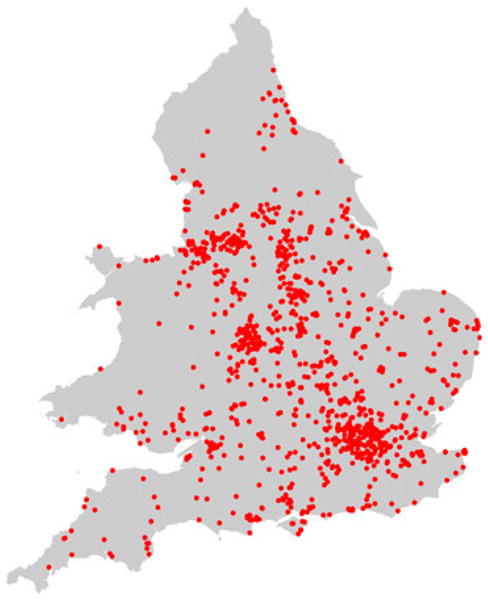
Location of families in the E-Risk study who were living in England and Wales and participated in Phase 12 assessment (n = 1,071)
Procedure
Google Street View came online in the United Kingdom in March 2009 and by March 2010, 94% of the E-risk children’s neighborhoods were available for viewing. Street View is a freely available tool that generates panoramic street-level views using high definition images taken from camera-equipped cars. Signals from global positioning devices are used to accurately position images in the online maps. To avoid gaps in the imagery, adjacent cameras on the car take overlapping pictures and the images are then stitched together to create a continuous 360-degree image of the street. Images are then smoothed and re-projected onto a sphere to create the image displayed in Street View (see Figure 2). To protect the privacy of individuals, face and license blurring technology is applied to ensure that people on the street and cars in the photographs cannot be identified.
Figure 2.
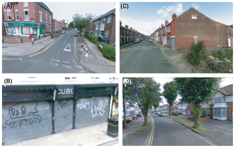
Google Street View images. (a) well kept neighborhood; children and ammenities visible on the street; roads and sidewalks in good condition. (b) evidence of graffitti; poorly kept sidewalk and trash container; sidewalks in fair condition. (c) deprived residential area; vacant lot in poor condition; heavy amount of litter; sidewalks and road in poor condition. (d) comfortably off residential area; roads and sidewalks in good conditions; no signs of litter, graffitti or other signs of disorder
The creation of the virtual SSO i-Tour protocol proceeded in four steps. First, in-person SSO instruments were adapted for use in a virtual context. To assist in the modification of the SSO i-Tour, a draft protocol was sent out for review by leading scholars in the field and a focus group was held with the UK-based study team. The protocol was then adapted for use within British neighborhoods and raters were recruited to complete the online SSO ratings. Although the virtual assessments could be conducted from anywhere in the world, we recruited individuals who were currently living and working in Britain as we felt these individuals would be in the best position calibrate their assessments of local neighborhood conditions.
Second, each SSO inventory - Tallying observations in Urban Regions (i-Tour) rater completed approximately 30 hr of training. A pre-selected set of 20 diverse neighborhoods was used to introduce raters to the SSO i-Tour, coding scheme and tools available in Google Street View. Scores among raters began to converge after the completion of approximately 15 neighborhoods. Inter-rater reliability checks were then performed at the 25%, 50%, and 75% completion points.
Third, the boundaries for each of the 1,012 neighborhoods were drawn within Google Street View. Three criteria were used to define the Street View coding area: (a) natural boundaries, such as street intersections or barriers, (b) a minimum distance of between .10 and .20 km, which corresponds with the average number of households in a postcode area in Britain, and (c) centering, wherever possible, the family’s home in the middle of the coding area. Coding rules were developed on a subsample of 40 neighborhoods and inter-rater reliability was calibrated on 30 randomly selected neighborhoods. Once inter-rater reliability was established, the average time to define the neighborhood boundaries was less than 1 min. Using tools available in Google Street View, lines were drawn and saved on each street to define the local neighborhood boundaries. Aerial views in Google Earth were then used to estimate the percentage of green space and presence of amenities within a .5 mile radius of the families’ home. We selected a .5 mile radius for coding as prior research using accelerometers and global positioning technology in England has found that the majority of children’s activities take place within 10 min (or 800 m/.5 miles) from their home (Jones, Coombes, Griffin, & Van Sluijs, 2009).
Fourth, raters entered into the neighborhoods using Google Street View and completed the SSO i-Tour while taking a virtual walk down the street. The average coding time per neighborhood was 17 min (range = 12–30 min). Coding was completed by four raters. A subset of neighborhoods (n = 120) were double coded at the 25%, 50%, and 75% completion points in the study. Observations were recorded using online survey software which meant that no additional data entry resources were required (as the data could be directly exported from the survey software) and that incoming data could be monitored and analyzed in real time.
Measures
Virtual SSO measures
SSO items were observed and recorded by raters as they took a virtual walk down each street in Google Street View. Descriptive information for each of the SSO measures is reported in Table 1.
Table 1.
Inter-rater agreement for Google Street View assessments
| Scale | Prevalence (%) (n = 1,012) | Observed agreement (n = 120) | Kappa κ (n = 120) | |
|---|---|---|---|---|
| Items | ||||
| Garbage or litter on street | Disorder | 51.3 | 78% | .55*** |
| Graffiti | Disorder | 21.9 | 82% | .53*** |
| Graffiti painted over | Disorder | 8.7 | 89% | – |
| Abandoned or burned out cars | Disorder | 4.8 | 87% | – |
| Vandalized/faded signs | Disorder | 7.1 | 79% | – |
| Sidewalk condition (poor/bad) | Decay | 34.8 | 71% | .31** |
| Street condition (poor/bad) | Decay | 27.5 | 66% | .19* |
| Deteriorated residential units | Decay | 22.8 | 78% | .42*** |
| Deteriorated gardens | Decay | 32.3 | 76% | .49*** |
| Unsafe place to live? | Danger | 11.5 | 87% | .50*** |
| Unsafe walking at night? | Danger | 27.8 | 63% | .26** |
| Traffic calming measures | Street safety | 22.6 | 93% | .79*** |
| Speed limit signs | Street safety | 12.1 | 94% | .66*** |
| Speed humps | Street safety | 15.7 | 93% | .75*** |
| Signs limiting traffic type | Street safety | 6.8 | 94% | – |
| Cross walk | Street safety | 9.3 | 87% | – |
| Bike lane | Street safety | 2.7 | 96% | – |
| No. of items | M (SD) | ICC1 | ICC2 | |
|---|---|---|---|---|
| Scales | ||||
| Physical disorder | 5 | 0.94 (1.00) | .59*** | .72*** |
| Physical decay | 4 | 1.42 (1.40) | .48*** | .74*** |
| Dangerous | 2 | 1.96 (1.05) | .66*** | .85*** |
| Street safety | 6 | 0.69 (1.03) | .84*** | .91*** |
| Percentage green spacea | 1 | 41.75 (25.83) | – | – |
The percentage of green space in a .5 mile radius was estimated for a subsample of neighborhoods (n = 200) to assess the feasibility of using aerial views in Google Earth and was not part of the inter-rater reliability assessment.
p-values, *<.05, **<.01, *** <.001. Kappa values: 0–.20 poor, .21–.40 slight, .40–.61 moderate, .61–.80 substantial, .80–1.0 almost perfect agreement (Landis & Koch, 1977). Kappa coefficients were not calculated for items with a base rate <10% as the expected chance agreement is inflated (and Kappa is lowered) in these cases (Feinstein & Cicchetti, 1990). Observed agreement = no. of cases agreed/total no. of cases. ICC = ratio of between-groups to total variance for scalar responses (Shrout & Fleiss, 1979). ICC1 = index of reliability for a single rater. ICC2 = index of reliability for multiple raters averaged together.
Signs of physical disorder included the presence of: garbage or litter on the street, graffiti or graffiti that had been painted over, abandoned or burned out cars and vandalized/faded signs (coded 0–1). A physical disorder scale for each neighborhood was created by summing the items.
Physical decay was coded based on signs that side-walks, streets, residential units and/or residential gardens were in ‘poor’ or’ badly deteriorated’ condition (coded 0–1). A physical decay scale was created for each neighborhood by counting the number of different types of physical decay observed on the street.
Neighborhood dangerousness was assessed via global ratings of whether the raters felt that the neighborhood was: ‘a safe place to live?’ and ‘somewhere they would feel safe walking at night?’ (coded 0–5). Because responses to these items where highly correlated (r = .70) they were averaged to compute a mean dangerousness rating for the neighborhood.
Street safety was coded as the presence of: traffic calming measures, speed or vehicle limiting signs, speed reducing humps, crosswalks and bike lanes (coded 0–1). Items were summed to create a diversity score indexing the number of different safety measures present on the street.
Percentage of green space was calculated using the aerial view in Google Earth view and recorded the percentage of the local area (.5 mile radius around the families’ home) that contained green space, including: parks, forests, large lawns, sports fields (coded 0–100). Percentage of green space was only gathered for a sub-sample of 200 neighborhoods to determine the feasibility of collecting this type of information in Google Earth.
Census derived socio-demographic classification
Neighborhood-level socioeconomic status was assessed using geo-demographic discriminators developed by a consumer marketing group for commercial use in Great Britain. A Classification of Residential Neighborhoods (ACORN) coding scheme was created using over 400 variables from the 2001 census and an extensive consumer research database (e.g., age, educational qualifications, unemployment, single-parent status, housing tenure and dwelling type, and car availability) to give a comprehensive picture of socioeconomic differences between areas. ACORN classifications are typically sold to businesses, health and local health authorities for marketing and planning purposes but the ratings were shared with our research team by their developers CACI Ltd (http://www.caci.co.uk/) for educational and research purposes. The ACORN classifications are provided at the Enumeration District (ED) level (~150 households). Hierarchical cluster analysis was used to group EDs into 56 neighborhood types and five distinct and homogeneous ordinal groups ranging from ‘Wealthy Achievers’ (category 1) with high incomes, large single-family houses and access to many amenities (25.6% of E-risk families and 25.3% of the UK population) to ‘Hard Pressed’ neighborhoods (category 5) dominated by government-subsidized housing estates, low incomes, high unemployment and single parents (26.1% of E-risk families and 20.7% of the UK population).
Local resident surveys
Neighborhood problems and dangerousness were assessed via postal surveys of residents living alongside each of the E-Risk families in 2008. Survey respondents were typically living on the same street or within the same apartment block as the children in our study. Surveys were returned by an average of 5.18 (SD = 2.73) respondents per neighborhood (range = 0–18 respondents). At least three responses were received for 80%, and at least two responses for 95%, of the neighborhoods (n = 5,601 respondents). Additional details regarding the resident survey methodology and measures are reported elsewhere (Odgers et al., 2009).
Neighborhood problems were measured by asking whether residents saw various types of disorder and crime in their neighborhood as a problem, including: ‘litter, broken glass, rubbish in public places?,’ ‘rundown buildings, abandoned cars, wastelands or vacant shop fronts?,’ or ‘vandals who do things like damage phone boxes, smash street lamps, break windows, or paint graffiti on walls?’ (coded 0–2). The 10 items were standardized and averaged to create a neighborhood problems total score (M = 0.09, SD = 0.60, α = .90).
Neighborhood danger was measured by asking residents to report whether they felt that their neighborhood was ‘generally a safe place’ (reverse coded 0–3, M = 0.84, SD = 0.77).
Child outcomes
Children’s antisocial behavior at age 12 was assessed with the Achenbach family of instruments (Achenbach, 1991a,b) and included items such as ‘bullies other children’, ‘steals’, ‘gets into fights’ and ‘truant’. Mother interviews and teacher reports of children’s behavior on the aggression and delinquency scales were combined by summing the items from each rater (coded 0–2) (M = 19.4, SD = 18.03, α = .90).
Prosocial behavior at age 12 was measured using items from the Revised Rutter Parent Scale for School-Age Children (Goodman, 1994) and included 20 items such as ‘kind to younger children’, ‘shares’, ‘considerate of others’, and ‘tries to be fair in games’. Mother interviews and teacher reports were combined by summing the items from each rater (coded 0–2) (M = 29.1, SD = 5.6, α = .87).
Healthy weight at age 10 and 11 was evaluated through mother reports of children’s height and weight gathered via mail-out survey. Children with BMI values falling between the 5th and 85th percentile were classified as having a healthy weight according to the Center for Disease Control sex and age adjusted cutoffs (Kuczmarski, Ogden, Guo, et al., 2000), 77.7% of the children were classified as falling within the healthy range. All subsequent analyses rely on comparisons between children who did versus did not fall into the healthy range based on their age and sex adjusted BMI value.
Results
Observed Agreement, kappa and intra-class correlation (ICC) coefficients for the virtual SSO measures were computed on a subset of 120 neighborhoods. Estimates are presented in Table 1 and illustrate three main findings. First, levels of observed agreement exceeded 70% for all but two of the 17 SSO items. Second, the highest levels of agreement were observed for the street safety items, with observed agreement exceeding 90% and evidence of substantial inter-rater agreement (κ’s > .65). Observed agreement surpassed 77% for the physical disorder items (with moderate levels of inter-rater agreement) and 63% for indicators of physical decay (with poor to moderate levels of agreement). Third, the intra-class correlations for the SSO-rated cumulative scales ranged from .48 to .91, indicating moderate to strong levels of agreement between the raters.
Convergent and discriminant validity of the SSO measures was evaluated by linking the virtual SSO data with census based classifications (ACORN measures), surveys completed by local residents and mother and teacher reports of children living in the neighborhood. The findings illustrate three main points. First, as expected, there was a positive and significant relationship between ACORN-defined deprivation and negative neighborhood features assessed in the virtual SSO study (Table 2, column 1, r’s range from .30 to .47). As illustrated in Figure 3, the relationship between neighborhood socioeconomic status and neighborhood disorder, decay and dangerousness was linear and could not be attributed solely to differences at the extremes of the distribution.
Table 2.
Correspondence between Google Street View SSO ratings and census and survey measures (n = 1,012)
| Google Street View assessments | Geo-demographic SES classification
|
Local Resident Survey
|
|
|---|---|---|---|
| ACORN | Neighborhood problems | Neighborhood dangerousness | |
| SSO negative neighborhood features | |||
| SSO physical disorder | .42** | .37** | .34** |
| SSO physical decay | .30** | .28** | .24** |
| SSO dangerousness | .47** | .44** | .40** |
| SSO positive neighborhood features | |||
| SSO percentage green space | −.36** | −.35** | −.27** |
| SSO street safety | .12** | .13** | −.10** |
SSO, systematic social observation; SES, socioeconomic status.
p-values, *<.05, **<.01 and are adjusted for the clustering of children within families.
Figure 3.
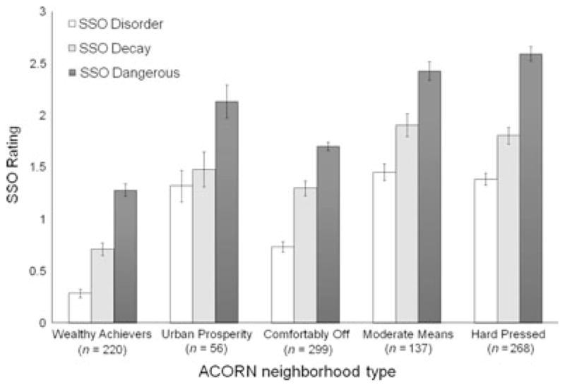
SSO-rated physical disorder, decay and dangerousness by ACORN-defined neighborhood types. Note: Error bars represent M ± SEM
Second, as displayed in Table 2, SSO-rated disorder, decay and dangerousness demonstrated positive and moderate-sized associations with resident reported neighborhood problems and dangerousness (r’s range from .24 to .44), while the percentage of green space in the local area was moderately and negatively associated with area deprivation, neighborhood problems and dangerousness (r’s ranged from −.27 to −.36). Street-safety measures demonstrated weak and inconsistent associations with deprivation and local resident reports.
Third, virtual SSO measures predicted children’s antisocial behavior, prosocial behavior and healthy weight status. As shown in Table 3, negative features of the neighborhood (disorder and dangerousness) significantly predicted children’s antisocial behavior, but were not related to children’s prosocial behavior or healthy weight status (correlations with antisocial behavior ranged from .05 to .11). Similarly, SSO-rated green space and street safety predicted whether children fell within the healthy weight range and exhibited prosocial behavior, respectively, but were not associated with children’s antisocial behavior. The associations provided in Table 3 also replicate the commonly reported association between neighborhood socioeconomic status and child outcomes, where children living in more deprived neighborhoods are more likely to exhibit higher levels of antisocial behavior, lower levels of prosocial behavior and experience more difficulties maintaining a healthy body weight. Similar to findings with the SSO-derived measures, resident reports of neighborhood problems and safety were associated with children’s antisocial behavior, but were not associated with prosocial behavior or weight status.
Table 3.
Bivariate associations between SSO rated neighborhood features and children’s antisocial behavior, prosocial behavior and healthy weight status
| Antisocial behavior | Prosocial behavior | Healthy weight (BMI) | |
|---|---|---|---|
| SSO negative neighborhood features | |||
| SSO physical disorder | .11** | .03 | .01 |
| SSO physical decay | .05 | .01 | −.03 |
| SSO danger | .11** | .02 | .04 |
| SSO positive neighborhood features | |||
| SSO % green spacea | −.05 | −.04 | .21** |
| SSO ‘child safe’ streets | .02 | .05* | −.02 |
| Census & resident survey measures | |||
| ACORN, neighborhood SES | .21** | −.06* | −.10** |
| Resident reported, Neighborhood problems | .16** | −.03 | .04 |
| Resident reported, Neighborhood dangerousness | .13** | −.01 | .05 |
SSO, systematic social observation.
Statistically significant correlations are in bold.
As noted in the measures section, n = 200 for associations between SSO-rated green space and child outcomes.
p-values, *<.05, **<.01, italicized p = .05 and are adjusted for the clustering of children within families. n’s range from 1,100 to 2,055 observations per cell. BMI values were available for a subsample of the E-Risk children due to the fact mothers responded to questions about their children’s weight status via mail out surveys gathered prior to the in-home assessments (n = 1,100 for correlations with healthy weight reported in Table 3). Tetrachoric correlations were calculated to estimate the association between SSO measures and healthy weight. Higher scores on ACORN, neighborhood SES indicate greater deprivation.
Discussion
Findings from this study support the use of Google Street View as a reliable and cost effective tool for gathering information about local neighborhoods. Acceptable levels of inter-rater agreement were documented for the majority of the virtual-SSO items and scales, providing evidence that both negative and positive neighborhood features can be reliably coded within a virtual context. As expected, neighborhoods classified as being the most ‘hard pressed’ based on census-derived algorithms were also characterized by the highest levels of SSO-rated disorder, decay and dangerousness by our team after taking a virtual walk down the streets. The linear and graded relationship between SSO virtual ratings and the ACORN-defined classifications of neighborhood socioeconomic status suggests that our SSO methodology was sensitive to differences in visible signs of disorder, decay and dangerousness across the entire gradient of neighborhoods in our study – which were representative of the UK population and ranged from the most affluent to the most deprived neighborhoods in Britain.
The virtual SSO measures also corresponded with ratings of neighborhood problems and dangerousness provided by residents living alongside the E-Risk families. Neighborhood surveys are often criticized for representing the perspectives of a select group of residents. Herein we provide evidence that resident surveys offer more than an idiosyncratic view of the neighborhood context as the views provided by residents were positively associated with the assessments made by our coding team. The positive and significant associations between resident reports and our virtual assessments suggests that online SSO studies may be a cost effective alternative for gathering (at least some of) the information about local neighborhoods captured by resident surveys. It is important to point out that key neighborhood-level social processes, such as levels of collective efficacy and intergenerational closure, cannot (yet) be captured within Google Street View. However, with the introduction of social networking tools and websites devoted to community life, researchers may want to consider how online tools may be used to gain additional insights into local settings.
Both negative and positive features of the neighborhoods in our study were associated with children’s behavior and health and there was evidence of specificity in the predictive power of the SSO measures. That is, SSO-rated negative aspects of the local neighborhood were positively associated with children’s antisocial behavior – but not with their prosocial behavior and healthy weight status, while SSO-rated positive features of the neighborhood were associated with children’s prosocial behavior and healthy weight status, but did not predict involvement in antisocial behavior. Future research with this sample will work to isolate the independent contributions of neighborhood structural factors and processes on children’s behavior and health, while considering the role of individual and family level factors over time.
The use of Google Street View as an innovative data-collection methodology should be interpreted in light of the following limitations. First, although people were present in over 60% of the neighborhoods we were unable to reliably code the activities of people on the street and assess signs of social disorder. In addition, the date and time that the images were taken was not available. This is important because neighborhood settings are likely to vary by time of day and year, with signs of disorder being most visible in the evening and during the summer months. Second, we were unable to capture small signs of physical disorder that have been routinely coded in SSO studies, including the presence of cigarette butts, needles and drug paraphernalia. Emerging research evaluating the use of Google Street View to audit neighborhoods in Chicago and New York also suggests that more finely detailed observations may be difficult to code reliably (Clarke, Ailshire, Melendez, Bader, & Morenoff, 2010; Rundle, Bader, Richards, Neckerman, & Teitler, 2011). With that said, prior in-person SSO studies have illustrated that these types of markers of social disorder, including evidence of drug paraphernalia and/or observations of individuals engaging in drug deals or other types of illegal activities are not frequently captured and, when they are, tend to be highly correlated with other signs of disorder (Sampson & Raudenbush, 1999). Third, all of the families in our study lived in Britain and it is unclear whether our results will generalize to other parts of the world. To help address this limitation we have made our SSO i-Tour instrument, coding materials, supporting documentation and a video instruction manual available for free use by other research teams as part of the online supplementary materials and on our research team’s website. Fourth, some individuals may be more likely to ‘see disorder’ than others (Sampson & Raudenbush, 2004) and it will be important to test whether factors such as gender, ethnicity, knowledge of the local area and/or prior exposure to neighborhood disorder may influence assessments within a virtual environment.
With these limitations in mind, we believe that the validation of a new and cost effective method of assessing neighborhood context is timely and may have far reaching consequences for the assessment of a diverse range of neighborhood effects. SSO studies have previously been embedded in ongoing longitudinal studies, but at great cost. Herein we present an alternative method of neighborhood assessment and suggest that it is possible to collect reliable and valid assessments of the neighborhood context for a fraction of the cost of conducting an in-person assessment. As a complement to the virtual-SSO approach, we also see the potential for ongoing studies to embed neighborhood assessments by asking researchers in the field to complete a brief audit of the immediate surroundings as it is likely that ratings of neighborhood features such as disorder, decay, safety and child/family friendly amenities could be gathered with relatively little extra time and expense.
Virtual SSO tools may also be useful as researchers start to break new ground testing how neighborhood features and stressors can ‘get under the skin’ and influence health (Miller, Chen, & Cole, 2009). For example, neuroscientists are beginning to look for validated measures of the social environment as they probe deeper into the finding that specific brain structures and responsivity to stress differ between people living in urban versus rural settings (Lederbogen et al., 2011). Simultaneously, creative field and laboratory-based experiments are being conducted to isolate how and why the presence of neighborhood features such as physical disorder (reliably assessed using our online SSO protocol) may influence behavior (Keizer, Lindenberg, & Steg, 2008). In short, it will be important for neighborhood assessments to keep pace with the rapid evolution of theory and research aimed at mapping the influence of the social environment on our brains and bodies. Ideally, the creation of reliable and cost effective tools for capturing neighborhood-level features will create new opportunities to isolate the mechanisms through which neighborhood settings influence our behavior and health.
It is somewhat fitting that our online SSO Study protocol was validated on neighborhoods in the United Kingdom given the early work of Charles Booth who generated color-coded poverty maps by visiting, literally, every street in London and triangulating observational data on disorder and poverty. Over a century later we used Google Street View to travel down many of these same streets and validate a novel method for capturing signs of neighborhood-level disorder, decay and safety that are believed to influence the health and safety of residents. As technology continues to provide new ways of measuring neighborhood settings, it will be important to keep pace with how this information can be used to advance science, build better communities and ultimately improve the lives of residents.
Key points.
Neighborhood conditions can have important and far reaching effects on health. However, gathering high-quality data on local neighborhoods can be time consuming, costly and difficult.
Our team used Google Street View to take a virtual walk through neighborhoods and conducted a systematic social observation (SSO) study of the streets where over 1,000 families participating in the Environmental-Risk Longitudinal Twin Study were living.
We found that virtual SSO assessments can offer a reliable and valid means of assessing both negative and positive features of the local neighborhood. Virtual SSO-measures could be reliably assessed by two or more raters, corresponded with independently gathered resident reports, and were significantly associated with children’s behavior and health.
The use of online tools may provide a cost effective way of advancing our understanding of how the neighborhoods we live in can influence behavior and health.
Acknowledgments
The E-Risk Study is funded by the Medical Research Council (UKMRC grants G1002190 and G9806489). Additional support was provided by ESRC grant RES-177-25-0013, NICHD grant HD061298, and by funds from the Jacobs Foundation, the British Academy, the Nuffield Foundation, and NIMH grant MH077874. The Community Strengths project is funded in part by Google. Candice L. Odgers is a William T. Grant Scholar. We are grateful to the study mothers and fathers, the twins, and the twins’ teachers for their participation. Our thanks to Louise Arseneault Michael Rutter and Robert Plomin, to Thomas Achenbach for kind permission to adapt the Child Behavior Checklist, and to members of the E-Risk team for their dedication, hard work, and insights. We also thank Ann Eve, James Eve and Jadwiga Mika for conducting the SSO assessments, Jill Collins and Paul Langston for their geo-coding assistance and Stephen Franklin for his assistance with Google Earth Professional.
Footnotes
Conflict of interest statement:
The authors declare no conflicts of interest. Candice L. Odgers had full access to all the data and takes responsibility for the integrity of the data and the accuracy of the data analysis.
The authors have declared that they have no competing or potential conflicts of interest.
References
- Achenbach TM. Manual for the child behavior checklist/4–18 and 1991 profile. Burlington: University of Vermont Department of Psychiatry; 1991a. [Google Scholar]
- Achenbach TM. Manual for the teacher’s report form and 1991 profile. Burlington: University of Vermont Department of Psychiatry; 1991b. [Google Scholar]
- Booth C. Labour and life of the people. Vol. 2. London: Williams and Norgate; 1891. [Google Scholar]
- Chen E, Paterson LQ. Neighborhood, family, and subjective socioeconomic status: How do they relate to adolescent health? Health Psychology. 2006;25:704–714. doi: 10.1037/0278-6133.25.6.704. [DOI] [PubMed] [Google Scholar]
- Clarke P, Ailshire J, Melendez R, Bader M, Morenoff J. Using Google Earth to conduct a neighborhood audit: Reliability of a virtual audit instrument. Health & Place. 2010;16:1224–1229. doi: 10.1016/j.healthplace.2010.08.007. [DOI] [PMC free article] [PubMed] [Google Scholar]
- CSDH. Closing the gap in a generation: Health equity through action on the social determinants of health. Final Report of the Commission on Social Determinants of Health. Geneva: World Health Organization; 2008. [Google Scholar]
- Duncan GJ, Brooksgunn J, Klebanov PK. Economic deprivation and early-childhood development. Child Development. 1994;65:296–318. [PubMed] [Google Scholar]
- Feinstein AR, Cicchetti DV. High agreement but low Kappa: I. The problems of two paradoxes. Journal of Clinical Epidemiology. 1990;43:543–549. doi: 10.1016/0895-4356(90)90158-l. [DOI] [PubMed] [Google Scholar]
- Goodman R. A modified version of the Rutter parent questionnaire including extra items on children’s strengths: A research note. Journal of Child Psychology and Psychiatry. 1994;35:1483–1494. doi: 10.1111/j.1469-7610.1994.tb01289.x. [DOI] [PubMed] [Google Scholar]
- Jones AP, Coombes EG, Griffin SJ, van Sluijs EMF. Environmental supportiveness for physical activity in English schoolchildren: A study using Global Positioning Systems. International Journal of Behavioral Nutrition and Physical Activity. 2009;6:42–50. doi: 10.1186/1479-5868-6-42. [DOI] [PMC free article] [PubMed] [Google Scholar]
- Keizer K, Lindenberg S, Steg L. The spreading of disorder. Science. 2008;322:1681. doi: 10.1126/science.1161405. [DOI] [PubMed] [Google Scholar]
- Kuczmarski RJ, Ogden CL, Guo SS, Grummer-Strawn LM, Flegal KM, Mei Z, Johnson CL. 2000 CDC growth charts for the United States: Methods and development. [accessed on 1 April 2012];National Center for Health Statistics Vital Health Statistics. 2000 11 http://www.cdc.gov/growthcharts/2000growthchart-us.pdf. [PubMed] [Google Scholar]
- Landis JR, Koch GG. The measurement of observer agreement for categorical data. Biometrics. 1977;33:159–174. [PubMed] [Google Scholar]
- Lederbogen F, Kirsch P, Haddad L, Streit F, Tost H, Schuch P, Deuschle M. City living and urban upbringing affect neural social stress processing in humans. Nature. 2011;474:498–501. doi: 10.1038/nature10190. [DOI] [PubMed] [Google Scholar]
- Marmot M, Friel S, Bell R, Houweling TAJ, Taylor S Commission on Social Determinants of Health. Closing the gap in a generation: Health equity through action on the social determinants of health. Lancet. 2008;372:1661–1669. doi: 10.1016/S0140-6736(08)61690-6. [DOI] [PubMed] [Google Scholar]
- Miller G, Chen E, Cole SW. Health psychology: Developing biologically plausible models linking the social world and physical health. Annual Review of Psychology. 2009;60:501–524. doi: 10.1146/annurev.psych.60.110707.163551. [DOI] [PubMed] [Google Scholar]
- Moffitt TE. Teen-aged mothers in contemporary Britain. Journal of Child Psychology and Psychiatry. 2002;43:727–742. doi: 10.1111/1469-7610.00082. [DOI] [PubMed] [Google Scholar]
- Murray CJL, Kulkarni SC, Michaud C, Tomijima N, Bulzacchelli MT, Iandiorio TJ, Ezzati M. Eight Americas: Investigating mortality disparities across races, counties, and race-counties in the United States. PLoS Medicine. 2006;3:e260. doi: 10.1371/journal.pmed.0030260. [DOI] [PMC free article] [PubMed] [Google Scholar]
- Odgers CL, Moffitt TE, Tach LM, Sampson A, Taylor RJ, Matthews CL, Caspi A. The protective effects of neighborhood collective efficacy on British children growing up in deprivation: A developmental analysis. Developmental Psychology. 2009;45:942–957. doi: 10.1037/a0016162. [DOI] [PMC free article] [PubMed] [Google Scholar]
- Papas MA, Alberg AJ, Ewing R, Helzlsouer KJ, Gary TL, Klassen AC. The built environment and obesity. Epidemiologic Reviews. 2007;29:129–143. doi: 10.1093/epirev/mxm009. [DOI] [PubMed] [Google Scholar]
- Reiss AJ. Systematic observation of natural social phenomena. In: Costner HL, editor. Sociological methodology. San Francisco: Jossey-Bass; 1971. pp. 3–33. [Google Scholar]
- Romeri E, Baker A, Griffiths C. Mortality by deprivation and cause of death in England and Wales, 1999–2003. London: Office for National Statistics; 2006. [PubMed] [Google Scholar]
- Rundle AG, Bader MDM, Richards CA, Neckerman KM, Teitler JO. Using Google Street View to audit neighborhood environments. American Journal of Preventive Medicine. 2011;40:94–100. doi: 10.1016/j.amepre.2010.09.034. [DOI] [PMC free article] [PubMed] [Google Scholar]
- Sampson RJ, Raudenbush SW. Systematic social observation of public spaces: A new look at disorder in urban neighborhoods. American Journal of Sociology. 1999;105:603–651. [Google Scholar]
- Sampson RJ, Raudenbush SW. Seeing disorder: Neighborhood stigma and the social construction of “Broken windows”. Social Psychology Quarterly. 2004;67:319–342. [Google Scholar]
- Sampson RJ, Raudenbush SW, Earls F. Neighborhoods and violent crime: A multilevel study of collective efficacy. Science. 1997;277:918–924. doi: 10.1126/science.277.5328.918. [DOI] [PubMed] [Google Scholar]
- Sastry N, Ghosh-Dastidar B, Adams J, Pebley AR. The design of a multilevel survey of children, families, and communities: The Los Angeles Family and Neighborhood Survey. Social Science Research. 2006;35:1000–1024. [Google Scholar]
- Shonkoff JP, Phillips D. From neurons to neighborhoods: The science of early childhood development. Washington, DC: National Academies Press; 2000. [PubMed] [Google Scholar]
- Shrout PE, Fleiss JL. Intraclass correlations: Uses in assessing rater reliability. Psychological Bulletin. 1979;86:420–428. doi: 10.1037//0033-2909.86.2.420. [DOI] [PubMed] [Google Scholar]
- Trouton A, Spinath FM, Plomin R. Twins Early Development Study (TEDS): A multivariate, longitudinal genetic investigation of language, cognition and behavior problems in childhood. Twin Research. 2002;5:444–448. doi: 10.1375/136905202320906255. [DOI] [PubMed] [Google Scholar]