Abstract
Remote sensing has been considered a low-cost, large-area coverage forest information resource ideally suited to broad-scale forest inventory objectives. The objective of this study is to determine stand type parameters such as crown closure, development stage and stand types, and land cover obtained from Landsat 7 ETM image and forest cover type map (stand type map). The research also focuses on classifying and mapping the stand parameters with the spatial analysis functions of GIS. In the study, stand parameters determined by forest cover type map and remote sensing methods were compared and contrasted to evaluate the potential use of the remote sensing methods. The result showed that development stage were estimated with Landsat 7 ETM image using supervised classification with a 0.89 kappa statistic value and 92% overall accuracy assessments. Among the features, development stages were the most successfully classified stand parameters in classification process. According to the spatial accuracy assessment results, development stages also had the highest accuracy of 72.2%. As can be seen in the results, spatial accuracy is lower than classification accuracy. Stand type had the lowest accuracy of 32.8. In conclusion, it could be stated that development stages, crown closure and land cover could be determined at an acceptable level using Landsat 7 ETM image. However, Landsat 7 ETM image do not provide means to map and monitor minor vegetation communities and stand types at stand level due to low spatial resolution. High resolution satellite images could be used either alone or with field survey data.
Keywords: forest management, GIS, landsat 7 ETM image, spatial analysis, stand parameters
1. Introduction
Forest inventory is extremely important for understanding and managing forest resources and ecosystems value [1]. Critical forest attributes, including stand type, site index, stem volume and increment per hectare, are assessed in stands by measuring individual trees in sample plots. Conventionally, forest inventory data has been gathered primarily through survey, which is expensive, cumbersome, and time-consuming [2]. The aim of traditional forest inventory is to provide impartial and reliable forest resource information, though typically these inventories deficiency fine spatial resolution. Remote sensing, Global Positioning System (GPS) and Geographic Information Systems (GIS) provide new opportunities for forest inventory and ecosystem values. It is possible to estimate forest parameters at fine spatial resolutions by integrating remote sensing, GPS and GIS [1].
Recently, satellite data, for example, Landsat satellite image, have been used successfully for large-area applications, such as for national forest inventories. Satellite remote sensing technologies are quite suitable to evaluate and monitor large-area forest attributes with reasonable accuracy levels. Specifically, optical satellite images have been successfully used in creating national forest inventories [2]. The use of remote sensing technologies has played an important role in creating forest stand information such as development stages, crown closures and land cover dynamics [3-7]. The remote sensing data has been accepted as a low-cost and large-area coverage information source in forestry resource management planning at large [8-12]. Generally, remote sensing in forest ecosystem inventory can be used to reduce field work and transform the field measurement results into various thematic maps for use in decision making [13]. Data regarding forest cover type such as tree species, crown closure and development stages as well as stand structure is needed to estimate forest biomass for calculating carbon budget, estimating forest productivity and meeting national forest inventory requirements. Remotely sensed data can easily be modified and used to restructure current strategies for mapping spatial features of resources particularly in large areas [14]. Various components of resolutions such as radiometric, spectral and geometric resolution of images will likely be enhanced in relation to technological development in remote sensing area to better detect and classify spatial objects [13]. The spectral response of forest composition and structure is quite informative in classifying forest components. Here, for example, various vegetation indices have been developed to be correlated with forest crown closure [7]. Although the spectral responses of forest composition with respect to the development stages [12, 14, 15], crown closures [12, 16] and height [12, 17] are reasonably understood, the exact relationship is highly related to the quality of remote sensing data as well as forest conditions under investigation. As indicated, stand parameters such as crown closures, development stages and height are inversely related to the spectral response of the stand parameters [12].
Remote sensing applications in the estimation of forest stand attributes such as development stages, crown closure have been intensively investigated during the last few years [2, 18-23]. Besides, some studies have conducted land cover change using remotely sensed data [24-26]. However, few studies have been focused on estimating forest stand parameters such as development stages, crown closure and forest stand types [13].
The objective of this study is to possibilities of determining forest stand parameters using remotely sensed data in a case study area of Ormanüstü forest, Trabzon, Turkey. The research also focuses on classifying and mapping the stand parameters such as development stages, crown closure, stand types, and land cover with the spatial analysis functions of GIS. Furthermore, stand parameters determined by forest cover type map and remote sensing methods were compared and contrasted to evaluate the potential use of the remote sensing methods.
2. Study Area
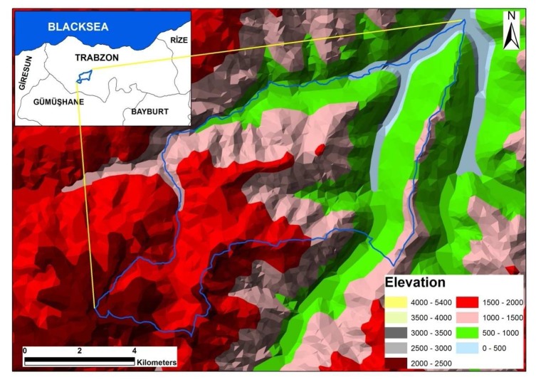
The study area is the Ormanüstü forest planning unit (OFPU) that covers 5990 ha in Eastern Black Sea Region of Turkey (536000-553000 E. 4507000-4519000 N. UTM ED 50 datum Zone 37N) (Figure 1). It is characterized by a dominantly rough and steep terrain with an average slope of 63%. The altitude ranges from 360 to 2279 m (Kuzu Korusu Hill) above sea level. The prevailing climate regime is Black Sea climate characterized by a mild winter, a cool summer, and with precipitation more or less homogeneous in all season. Average annual temperature reaches a maximum of 20.2°C in the summer, a minimum of 4.5°C in the winter with an on average annual temperature of 12.2°C and average annual precipitation of 640.9 mm [27]. Main soil types are loam sandy and sandy loam. Forest in the study area is composed of pure, mixed, even-aged, naturally regenerated and uniformly stocked stands without any evidence of history of damage by fire or storm. By the way, can there be a fire problem in an area with a lot of precipitation all year around.
Figure 1.
The geographic location of the study area surrounded with solid blue lines.
3. Materials and Methods
3.1. Dataset and Methods
The data used in this research are forest cover type map at 1/25.000 scale for year 2006 and Landsat 7 ETM satellite image acquired on July 17, 2000. The forest stand types used as ground truthing were originally generated from both the stereo interpretation of infrared aerial photos with an average 1/16.000 scale and ground measurements of sample points distributed by 300×300 m grids in 2006.
Data processing involved a number of steps. First of all, the forest cover type map (2006) was drafted and spatial database was build with Arc/Info 9.2. Second, Landsat 7 ETM image was rectified and classified to create stand type, crown closure, development stages and forest cover type maps. Third, spatial accuracy was evaluated using both forest cover type map and Landsat 7 ETM image. Stand type, crown closure, development stages, and land cover polygon themes obtained from both forest cover type map and Landsat 7 ETM image were overlaid and areas that are in the same classes in both forest cover type map and Landsat 7 ETM image were computed with GIS.
Two methods were used in estimating the accuracy of classification. Firstly, areal estimation method refers to the general classification of stand parameters for satellite image only. Secondly, stand parameters estimation method refers to the classification from forest cover type map and Landsat 7 ETM image. In the latter method, forest cover type map and the classified Landsat 7 ETM image were overlaid to each other and the results were evaluated.
3.2. Geometric Correction of Landsat 7 ETM Image
Image processing, classification and spatial analysis were carried out using ERDAS Imagine 8.6™ and Arc/info 9.2. Subsets of satellite image were rectified using 1:25.000 scale Topographical Maps with UTM projection (ED 50 datum) using first order nearest neighbor rules. A total of 24 ground points were used to register the ETM image subset a rectification error less than 1 pixel image.
3.3. Classification of Landsat 7 ETM Image
In this study, we used to 5, 4, 3 spectral bands combination in image classification. Ground reference data was gathered as signatures for satellite image and the training points were equally distributed to each stand type with at least 10 points per stand type. In order to classify cover types from the image using supervised classification method, signatures were taken from these ground corrected forest cover type map of 2006. The signatures were further controlled with image enhancement techniques such as Transformed Vegetation Index and Principle Components Analysis-PCA. Equal numbers of control points were used with at least 30 points for each class to determine the accuracy of classification method [28]. As the accuracy assessment of image is checked, equal numbers of control points with at least 30 points for each forest cover stand type class were not realized due to not sufficient area for some forest stand type class. After accuracy assessment, Landsat 7 ETM image were clumped to eliminate 2×1 pixels and vectorized into polygons. Landsat 7 ETM image was classified into five land cover classes successfully: Conifer Forest (CF), Mixed Forest (MF), Degraded Forest (DF), Forest Openings (FO) and Agriculture-Range (AR) including agriculture lands (Table 1). Broadleaf Forest (BF) was not classified in Landsat 7 ETM image due to small areas scattered around. This classification is fully acceptable due to a higher overall classification accuracy of 89 % and 0.86 kappa statistics value. Besides, all user's and producer's accuracy for all forest cover classes are much higher than 80 %.
Table 1.
Land Cover Classes descriptions.
| Land Cover Classes | Description |
|---|---|
| Conifer Forest (CF) | Forest areas with pure conifer trees |
| Broadleaf Forest (BF) | Forest areas with pure broadleaf trees |
| Mixed Forest (MF) | Mixed (BF-CF, CF-BF) forest areas whose stand crown closure is greater than 10% |
| Degraded Forest (DF) | Degraded forest areas with estimated < 10% tree crown cover |
| Forest Openings (FO) | Treeless areas |
| Agriculture and Range (AR) | Agricultural lands and range areas |
Landsat 7 ETM image was further classified into seventeen forest stand type classes. The overall accuracy of classification was 78% and the kappa statistics was 0.76, which is generally acceptable. Crown closure was classified into four classes; 2 (medium coverage of 41-70%), 3 (full coverage of 71-100%), degraded forest (sparsely distributed, 0-10% closure) and other (forest openings, agriculture and range area). However, crown closure was classified to five classes in forest cover type map classes. Crown closure 1 (low coverage of 11-40%) was not classified in Landsat 7 ETM image due to having small area (2.1 ha). The overall accuracy of classification was 81% and the kappa statistics was 0.86, which is quite acceptable. As for development stages, we defined four classes in Landsat 7 ETM image: a (regenerated area, average dbh <8 cm); b (immature area, average dbh 8-19.9 cm); c (mature area, average dbh 20-35.9 cm) and others (forest openings, agriculture and range area). The overall accuracy of the classification was 92% and the kappa statistics was 0.89 which is also quite acceptable.
4. Results and Discussion
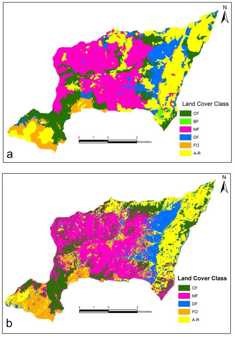
The Landsat 7 ETM image was successfully classified into stand type parameters and land cover. Land cover classes, mapped (Figure 2) using the area statistics (Table 2) derived from forest cover type map and classified Landsat 7 ETM image. According to the land cover type map, DF class was the most successfully classified in Landsat 7 ETM image. The biggest area difference was in AR class (264.6 ha, 4.4% of the landscape) class. MF was 2023.2 ha in forest cover type map while it was 2085.4 ha in classified Landsat 7 ETM image. The areas of CF, MF and DF classes obtained from forest cover type map and classified Landsat 7 ETM image was pretty much similar to each other. However, the situation is different in FO and AR areas. FO was 402.6 ha in forest cover type map while it was 568.1 ha in classified Landsat 7 ETM image. Also, AR was 1709.3 ha in land cover map obtained from forest cover type map while it was 1444.7 ha in classified Landsat 7 ETM image. There was a net 165.5 ha and 264.6 ha differences in FO and AR, respectively. Such differences came from the fact that FO and AR have similar reflectance values in Landsat 7 ETM image.
Figure 2.
Land cover class map generated from a) forest cover type map b) Landsat 7 ETM image.
Table 2.
Changes in land cover class in forest cover type map, Landsat 7 ETM image and spatial analysis.
| Land Cover Class | Forest Cover Type Map | Landsat 7 ETM | Difference (+/-) | Spatial Analysis | |||
|---|---|---|---|---|---|---|---|
|
|
|
|
|||||
| ha | % | ha | % | ha* | % | ||
| CF | 1119.4 | 18.7 | 1201.8 | 20.1 | -82.4 | 621.8 | 51.7 |
| BF | 40.6 | 0.7 | 0.0 | 40.6 | - | 0.0 | |
| MF | 2023.2 | 33.8 | 2085.4 | 34.8 | -62.2 | 1507.9 | 72.3 |
| DF | 694.9 | 11.6 | 690.0 | 11.5 | 4.9 | 345.2 | 50.0 |
| FO | 402.6 | 6.7 | 568.1 | 9.5 | -165.5 | 229.7 | 40.4 |
| AR | 1709.3 | 28.5 | 1444.7 | 24.1 | 264.6 | 953.4 | 66.0 |
| Total | 5990.0 | 100.0 | 5990.0 | 100.0 | |||
The area that is the same spatial configuration in both forest cover type map and Landsat 7 ETM image.
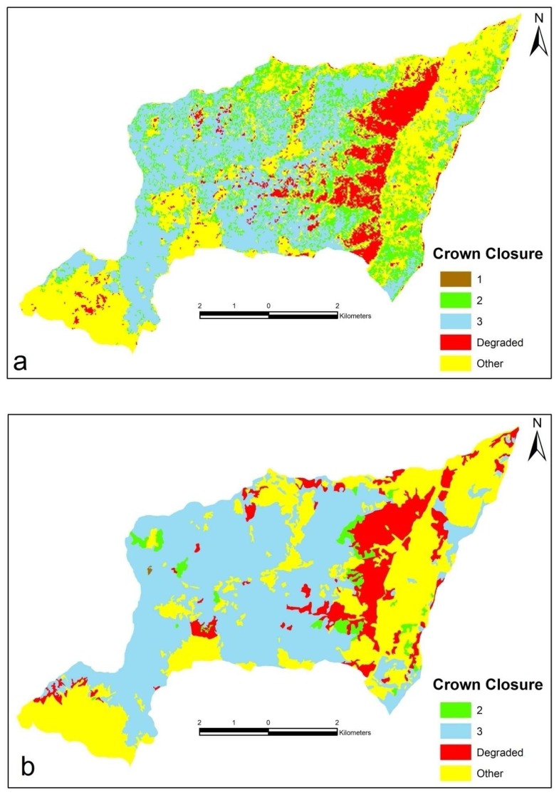
Landsat 7 ETM image was classified successfully into five crown closure classes (Table 3 and Figure 3). The low crown closure (11-40%) class was not classified successfully in Landsat 7 ETM image due to small area coverage (2.1 ha, 0.03% of the landscape). The full coverage (71-100%) was 3029.5 ha in forest cover type map while it was 2192.7 ha in land cover map obtained from Landsat 7 ETM image. When crown closure values were further analyzed, it was seen clearly that there were significant differences between areas in the medium crown closure (41-70%) class obtained from forest cover type map and Landsat 7 ETM satellite image. Medium closure was 151.5 (2.5%) ha in forest cover type map and 1057.5 (17.7%) ha in classified Landsat 7 ETM image with a 906.0 ha differences. The most important factors of this difference were similar reflectance values and small areas. Similarly, there was a net 836.8 ha differences in full closure class. The differences in both medium closure class and full closure class are almost the same because reflectance values of both classes were. These results are quite comparable to similar other research results Pilger [14] classified land cover class and crown closure using Landsat TM with 0.68 and 0.56 Kappa statistics. Similarly, Sivrikaya [29] classified land cover classes in Artvin Forest Planning Unit (FPU) with 82.1% accuracy 0.79 Kappa statistics in Bulanıkdere FPU was 88.7% accuracy and 0.87 Kappa statistics. According to spatial analysis, however, the accuracy of land cover was 64.2% in Bulanıkdere FPU and 44.2% in Artvin FPU. Other researches completed about land cover classification use Landsat ETM image, Kadıoğulları and Baskent [26] classified Gümüşhane Forest enterprise has typical mountain areas with accuracy of 86.58% and 0.8452 Kappa statistics values and Baskent and Kadıoğulları [37] classified İnegöl Forest Enterprise has Typical alluvial areas with a higher overall classification accuracy of 91.04% and 0.9018 Kappa statistics value. As a result, accuracy assessment in spatial analysis is lower than the classification accuracy.
Table 3.
Changes in crown closure class in forest cover type map, Landsat 7 ETM image and spatial analysis.
| Crown Closure Class (criteria (% cover)) | Forest Cover Type Map | Landsat 7 ETM | Difference (+/-) | Spatial Analysis | |||
|---|---|---|---|---|---|---|---|
|
|
|
|
|||||
| ha | % | ha | % | ha* | % | ||
| 1 (low coverage. 11-40 %) | 2.1 | 0.0 | - | 0.0 | 2.1 | - | 0.0 |
| 2 (medium coverage. 41-70 %) | 151.5 | 2.5 | 1057.5 | 17.7 | -906 | 67.3 | 6.4 |
| 3 (full coverage. 71-100 %) | 3029.5 | 50.6 | 2192.7 | 36.6 | 836.8 | 1994.9 | 91.0 |
| Degraded forest (sparsely distributed. 0-10 %) | 694.9 | 11.6 | 629.0 | 10.5 | 65.9 | 306.9 | 48.8 |
| Other | 2112.0 | 35.3 | 2110.8 | 35.2 | 1.2 | 1471.3 | 69.7 |
|
| |||||||
| Total | 5990.0 | 100.0 | 5990.0 | 100.0 | |||
The area that is the same spatial configuration in both forest cover type map and Landsat 7 ETM image.
Figure 3.
Crown closure map generated from a) forest cover type map b) Landsat 7 ETM image.
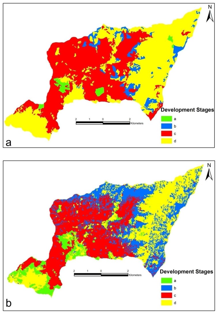
The development stages were mapped (Figure 4) and analyzed using the area statistics (Table 4) obtained from forest cover type map and Landsat 7 ETM image. The development stage a was 231.0 ha in Landsat 7 ETM image and 126.3 ha in forest cover type map. In other words, development stage a was the most successfully classified in Landsat 7 ETM image. There was a large area difference (772.5 ha, 12.9 %) in development stage b class obtained from both methods. There are areal differences in development stage b as it has similar reflectance values with other development stages.
Figure 4.
Development stages map generated from a) forest cover type map b) Landsat 7 ETM image.
Table 4.
Changes in development stages class in forest cover type map, Landsat 7 ETM image and spatial analysis.
| Development Stages Class (criteria (average dbh)) | Forest Cover Type Map | Landsat 7 ETM | Difference (+/-) | Spatial Analysis | |||
|---|---|---|---|---|---|---|---|
|
|
|
|
|||||
| ha | % | ha | % | ha* | % | ||
| a (regenerated <8 cm) | 126.3 | 2.1 | 231.0 | 3.9 | -104.7 | 35.8 | 15.5 |
| b (young 8-19.9 cm) | 420.7 | 7.0 | 1193.2 | 19.9 | -772.5 | 252.1 | 21.1 |
| c (nature 20-35.9 cm) | 2634.0 | 44.0 | 2248.3 | 37.5 | 385.7 | 1995.3 | 88.7 |
| Other | 2809.0 | 46.9 | 2317.5 | 38.7 | 491.5 | 2043.3 | 88.2 |
|
| |||||||
| Total | 5990.0 | 100.0 | 5990.0 | 100.0 | |||
The area that is the same spatial configuration in both forest cover type map and Landsat 7 ETM image.
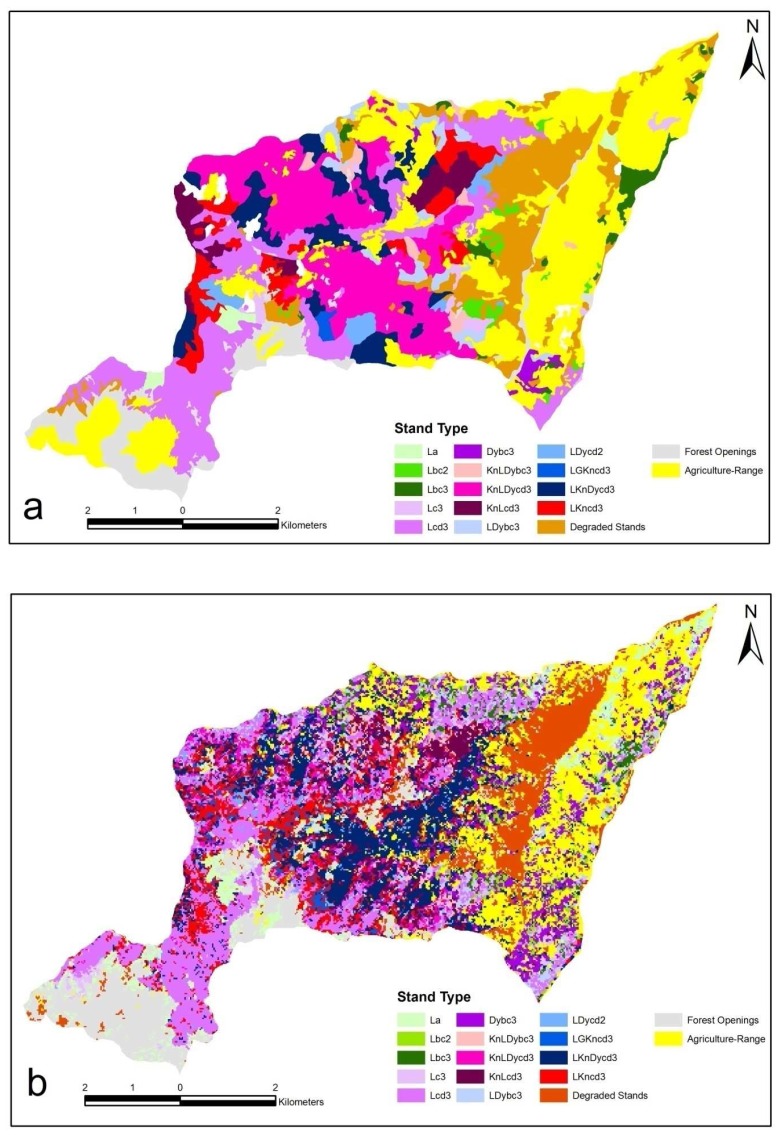
There were significant differences between stand type class areas obtained from stand types and classified Landsat 7 ETM image (Figure 5 and Table 5). The smallest area difference (22.3 ha, 2.7% of the stand type class) was in Lcd3 stand type obtained from both methods. In other words, Lcd3 stand type was the most successfully classified in Landsat 7 ETM image due to its homogeneity. The biggest area difference (751.2 ha, 12.5%) was in KnLDycd3 stand type as it was more heterogeneous. It was seen clearly that pure conifer stand types were more successfully classified than mixed stands. Most of the planning unit consists of mixed stands that are composed of conifer and broadleaf tree species were resulted in less successful classification.
Figure 5.
Stand type map generated from a) forest cover type map b) Landsat 7 ETM image.
Table 5.
Changes in stand type class in forest cover type map, Landsat 7 ETM image and spatial analysis.
| Stand Type Class | Forest Cover Type Map | Landsat 7 ETM | Difference (+/-) | Spatial Analysis | |||
|---|---|---|---|---|---|---|---|
|
|
|
|
|||||
| ha | % | ha | % | ha* | % | ||
| La | 52.6 | 0.9 | 302.0 | 5.0 | -249.4 | 28.2 | 9.3 |
| Lbc2 | 62.5 | 1.0 | 161.5 | 2.7 | -99.0 | 12.7 | 7.9 |
| Lbc3 | 101.3 | 1.7 | 93.8 | 1.6 | 7.5 | 19.5 | 20.8 |
| Lc3 | 62.8 | 1.0 | 123.5 | 2.0 | -60.7 | 7.8 | 6.3 |
| Lcd3 | 829.3 | 13.8 | 807.0 | 13.5 | 22.3 | 432.7 | 53.6 |
| Dybc3 | 106.6 | 1.8 | 364.8 | 6.1 | -258.2 | 20.3 | 5.6 |
| KnLDybc3 | 62.1 | 1.1 | 130.8 | 2.2 | -68.7 | 6.4 | 4.9 |
| KnLDycd3 | 905.9 | 15.1 | 154.7 | 2.6 | 751.2 | 87.9 | 56.8 |
| KnLcd3 | 164.3 | 2.8 | 265.9 | 4.4 | -101.6 | 59.1 | 22.2 |
| LDybc3 | 123.9 | 2.1 | 191.3 | 3.2 | -67.4 | 29.2 | 15.3 |
| LDycd2 | 92.4 | 1.5 | 110.7 | 1.8 | -18.3 | 5.9 | 5.3 |
| LGKncd3 | 18.3 | 0.3 | 57.2 | 1.0 | -38.9 | 6.9 | 12.0 |
| LKnDycd3 | 340.4 | 5.7 | 743.8 | 12.4 | -403.4 | 13.9 | 1.9 |
| LKncd3 | 260.9 | 4.4 | 435.5 | 7.3 | -174.6 | 19.3 | 4.4 |
| DF | 694.9 | 11.6 | 561.2 | 9.4 | 133.7 | 296.8 | 52.9 |
| FO | 402.6 | 6.7 | 574.8 | 9.6 | -172.2 | 244.3 | 42.5 |
| AR | 1709.2 | 28.5 | 911.5 | 15.2 | 797.7 | 673.9 | 73.9 |
|
| |||||||
| Total | 5990.0 | 100.0 | 5990.0 | 100.0 | |||
The area that is the same spatial configuration in both forest cover type map and Landsat 7 ETM image. Kn: Beech, L: Spruce, Dy: Hardwood species, G: Fir, DF: Degraded Forest, FO: Forest Opennings, AR: Agriculturel-Range, 2.3: Crown closure, a. b. c. d: Development stages, Lc3: spruce stand, nature development stage (20-35.9 cm), full coverage. (71-100%).
There is an increasing need to analyze the development of spatial structure of forests and stand type parameters and develop means by which spatial objectives can be explicitly accommodated in forest planning [30, 31]. Without analyzing spatial detail for ecosystem and stand parameters, it is impossible to maintain a number of environmental and ecological conditions like maintaining biological diversity, limiting sediment loading in streams, limiting habitat disruption in an area, preventing a view shed from being impacted too heavily, ensuring that open forage areas are provided for certain animals [30, 32, 33, 34, 35]. Such efforts in forest-management planning have pushed to better recognize spatial concerns [36]. To recognize better decision, evaluation of forest values and alternative policies, spatially explicit stand parameters such as development stages, crown closure, stand type, and land cover class need to be determined. So far, simple areal differences among classes evaluated, now spatial comparisons of stand parameters were conducted.
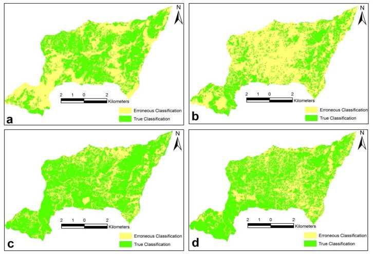
Here, stand parameters such as stand type, crown closure, development stage, and land cover polygon themes obtained from both forest cover type map and Landsat 7 ETM image were overlaid and areas that are in the same classes spatially in both stand type and Landsat 7 ETM image were computed with GIS (Figure 6). While it appears to be successful, in fact it's not.
Figure 6.
Comparisons of spatial analysis with a) land cover b) forest cover type map c) development stages and d) crown closure.
According to spatial analyses results of land cover class, 621.8 ha CF (51.7 %), 1507.9 ha MF (72.3 %), 345.2 ha DF (50.0 %), 229.7 ha FO (40.4 %) and 953.4 ha AR (66.0 %) areas were spatially classified successfully. In other words, 621.8 ha CF was in the same spatial configuration size, shape and spatial configuration in both forest cover type map and Landsat 7 ETM image. DF was 694.9 ha in forest cover type map and 690.0 ha in classified Landsat 7 ETM image. While it appears to be successful, in fact it's not. The spatial analysis indicates that of the 690 ha DF, only 345.2 ha (50.0%) was determined in DF class, the rest of 344.8 ha (50.0%) was in fact in other land cover classes, indicating significant misrepresentation of sites. Similarly, of the 568.1 ha FO, nearly 338.4 ha (59.6%) was in fact in other land cover classes. General analysis showed that spatial accuracy of land cover class was 61.7 %.
When crown closure was spatially analyzed, 1994.9 ha (65.8 %) area of full closure and 67.3 ha (44.4 %) the medium coverage areas were spatially classified successfully. Of the 2192.7 ha full closure, nearly 1994.9 ha (91.0%) was determined in the same class. Leaving, nearly 197.8 ha (9.0%) in fact in other crown closure class indicating erroneous interpretation of sites. Taken into consideration of all classes in crown closure, spatial accuracy of crown closure class was 64.2%.
According to spatial analyses of development stage classes result in development stage a of 35.8 ha (15.4%), development stage b of 252.1 ha (21.1 %) and development stage c of 1995.3 ha (88.7%) areas were successfully classified for spatial analyses. Of the 2248.3 ha nature class, nearly 1995.3 ha (88.7%) was determined in nature class. In other words, nearly 253.0 ha (11.3%) was in fact in other development stage class. The spatial analyses success was found 72.2 % for development stage class in study area.
The spatial analyses of stand type class showed that the best result was found in Lcd3 stand type (432.7 ha, 53.6 %) and the worst result was found in LKnDycd3 stand type (13.9 ha, 1.9%) in Landsat 7 ETM image. Leaving 729.9 ha (88.1%) in other stand type classes indicating a significant misrepresentation of sites. The spatial analyses success was found 32.8 % for stand type in study area.
5. Conclusion
Identification and classification stand parameters through remote sensing are challenging endeavor in forest management. In this study, the stand parameters such as stand type, crown closure, development stage, and land cover were obtained from both forest cover type map and Landsat 7 ETM image and overlaid to each other to spatially recognize the similarities in classes in both forest cover type map and Landsat 7 ETM image. This study revealed the differences between areal accuracy and spatial accuracy of stand parameters and land cover. The differences were quite significant and should be taken into consideration in forest management. The result indicated that the Landsat 7 ETM image was not suitable for determining stand types due to heterogeneity in forest stands in the study area. However, stand parameters were determined such as crown closure, development stages, and land cover was successfully determined using Landsat 7 ETM image. In conclusion, with the spatial and spectral resolution of Landsat 7 ETM satellite image provide relatively good means for mapping and monitoring land cover, development stage and crown closure at a landscape level. The overall spatial accuracy was over 80% which acceptable in forest management, while detecting stand types was quite lower and not acceptable as is. However, Landsat 7 ETM satellite image do not provide means for mapping and monitoring minor vegetation community and stand types due to low resolution. Thus, high resolution satellite images should be used either alone or with field survey data to recognize stand types and lesser vegetation.
Acknowledgments
We would like to extend our appreciation and thanks to the two forest management team leaders whose names are Caner Akgül and Mehmet Ali Sayın and their stuff assigned to prepare forest management plan in Maçka-Ormanustu.
Reference
- 1.Meng Q. Geostatistical prediction and mapping for large area forest inventory using remote sensing data. www.ucgis.org/summer/studentpapers/Mengqm_July03_2006.pdf.
- 2.Hyyppa J., Hyyppa H., Inkinen M., Engdahl M., Linko S., Zhu Y. Accuracy comparison of various remote sensing data sources in the retrieval of forest stand attributes. For. Ecol. Manage. 2000;128:109–120. [Google Scholar]
- 3.Houghton R.A., Woodwell G.M. Proc Seventh International Symposium on Machine Processing of Remote Sensed Data. West Lafayette, Indiana: 1981. Biotic contributions to the global carbon cycle: the role of remote sensing; pp. 593–602. [Google Scholar]
- 4.Botkin D.B., Estes J.E., McDonald R.M., Wilson M.V. Studying the Earth's vegetation from space. Bioscience. 1984;34:508–514. [Google Scholar]
- 5.Malingreau J.P. In: Remote sensing for tropical forest monitoring: an overview; in Remote Sensing and Geographical Information Systems for Resource Management in Developing Countries. Belward A.S., Valenzuela C. R., editors. Dordrecht: Kluwer; 1991. pp. 253–278. [Google Scholar]
- 6.Roy P.S. In: Remote sensing for forest ecosystem analysis and management: in environmental studies in India. Balakrishnan M, editor. New Delhi: Oxford and IBH; 1993. pp. 335–363. [Google Scholar]
- 7.Roy P.S., Sharma K.P., Jain A. Stratification of density in dry deciduous forest using satellite remote sensing digital data, an approach based on spectral indices. J. Biosciences. 1996;21:723–734. [Google Scholar]
- 8.Poso S., Hame T., Paananen R. A method of estimating the stand characteristics of a forest compartment using satellite imagery. Silva Fenn. 1984;18:261–292. [Google Scholar]
- 9.Wulder M.A. Optical remote sensing techniques for the assessment of forest inventory and biophysical parameters. Progress in Physical Geography. 1998 a;22:449–476. [Google Scholar]
- 10.Andersen G.L. A Review of methodologies, classification and estimation of forest and vegetation variables in optical high resolution satellites. International Institute for Applied Systems Analysis; Austria: 1998. Interim Report IR-98-085. [Google Scholar]
- 11.Wynne R.H., Oderwald R.G., Reams G.A., Scrivani J.A. Optical remote sensing for forest area estimation. J. Forest. 2000;98:31–36. [Google Scholar]
- 12.Franklin S.E., Hall R.J., Smith L., Gerylo G.R. Discrimination of conifer height, age and crown closure classes using Landsat-5 TM imagery in the Canadian Northwest territories. Int. J. Remote Sens. 2003;24(9):1823–1834. [Google Scholar]
- 13.Yeşil A., Musaoğlu N., Kaya Ş., ÇoŞkun G., Asan Ü., Örmeci C. Statistical modelling and stand type forest mapping selected area around Istanbul using Landsat-TM and Spot data. International Symposium on Remote Sensing and Integrated Technologies; 2002 20-22 October; Istanbul, Turkey. pp. 291–300. Proceeding. [Google Scholar]
- 14.Pilger N., Peddle D.R., Luther J.E. Estimation of forest cover type and structure from Landsat TM imagery using a canopy reflectance model for biomass mapping in Western Newfoundland; 2002. http://ieeexplore.ieee.org/iel5/7969/22038/01026103.pdf. [Google Scholar]
- 15.Jensen J.R., Qiu F., Mınhe J. Predictive modeling of coniferous forest age using statistical and artificial neural network approaches applied to remote sensor data. Int. J. Remote Sens. 1999;20:2805–2822. [Google Scholar]
- 16.Spanner M.A., Pierce L.L., Running S.W., Peterson D.L. Remote sensing of temperate coniferous forest leaf area index: the influence of canopy closure, understory vegetation and background reflectance. Int. J. Remote Sens. 1990;11:95–111. [Google Scholar]
- 17.Gemmel F.M. Effects of forest cover, terrain, and scale on timber volume estimation with Thematic Mapper data in a Rocky Mountain site. Remote Sens. Environ. 1995;51:291–305. [Google Scholar]
- 18.PaÈivinen R., Pussinen A., Tomppo E. Assessment of boreal forest stands using field assessment and remote sensing. Proceedings of Earsel Conference Operationalization of Remote Sensing; ITC Enshedene, The Netherlands. 19-23 April 1993. [Google Scholar]
- 19.Kasischke E.S., Christensen N.L., Bourgeau-Chavez L.L. Correlating radar backscatter with components of biomass in loblolly pine forests. IEEE Trans. Geosci. Remote Sensing. 1995;33:643–659. [Google Scholar]
- 20.Wegmüller U., Werner C.L. SAR interferometric signatures of forest. IEEE Trans. Geosci. Remote Sensing. 1995;33:1153–1161. [Google Scholar]
- 21.Chiao K.M. Comparisons of three remotely sensed data on forest crown closure and tree volume estimations. Int. Archives of Photogrammetry and Remote Sensing. 1996;31:123–130. Part B7. [Google Scholar]
- 22.Ranson K.J., Sun G., Montgomery B., Lang R.H. Mapping of boreal forest biomass using SAR. Proceedings of IGARSS'96 Conference; Lincoln, NE. 27-31 May 1996; pp. 577–579. [Google Scholar]
- 23.Hyyppa J., Pulliainen J., Hallikainen M., Saatsi A. Radar derived standwise forest inventory. IEEE Trans. Geosci. Remote Sensing. 1997;35:392–404. [Google Scholar]
- 24.Çakır G., Sivrikaya F., Keleş S. Forest cover change and fragmentation using Landsat data in Maçka State Forest Enterprise in Turkey. Environ. Monitor. Assess. 2008;137:51–66. doi: 10.1007/s10661-007-9728-9. [DOI] [PubMed] [Google Scholar]
- 25.Keleş S., Sivrikaya F., Çakır G. Temporal changes in forest landscape patterns in Artvin forest planning unit, Turkey. Environ. Monitor. Assess. 2007;129:483–490. doi: 10.1007/s10661-006-9380-9. [DOI] [PubMed] [Google Scholar]
- 26.Kadıoğulları A.İ, Baskent E.Z. Spatial and temporal dynamics of land use pattern in Eastern Turkey: a case study in Gümüşhane. Environ. Monitor. Assess. 2008;138:289–303. doi: 10.1007/s10661-007-9798-8. [DOI] [PubMed] [Google Scholar]
- 27.Altun L. PhD thesis. Karadeniz Technical University, The Graduate School of Natural and Applied Sciences; Trabzon: Turkey: 1995. The role of site factors in distinguishing forest sites in Trabzon-Maçka Ormanustu forest. [Google Scholar]
- 28.Erdas Field Guide 6th edition. Erdas LLC; Atlanta, Georgia: 2002. [Google Scholar]
- 29.Sivrikaya F., Keleş S., Çakır G., Başkent E.Z., Köse S. Comparing accuracy of classified Landsat data with land use maps reclassified from the stand type maps. 7th International Syposium on Spatial Accuracy Assessment in Natural Resources and Environmental Sciences. 2006:643–652. [Google Scholar]
- 30.Baskent E.Z., Keles S. Spatial forest planning: A review. Ecol. Model. 2005;188:145–173. [Google Scholar]
- 31.Bettinger P., Sessions J. Spatial forest planning: to adopt, or not to adopt.? J. Forestry. 2003;101(2):24–29. [Google Scholar]
- 32.Church R.L., Murray A.T., Weintraub A. Locational issues in forest management. Location Sci. 1998;6:137–153. [Google Scholar]
- 33.Baskent E.Z. Combinatorial optimization in forest ecosystem management modeling. Turk. J. Agric. For. 2001;25:187–194. [Google Scholar]
- 34.Kurttila M. The spatial structure of forests in the optimization calculations of forest planning: a landscape ecological perspective. Forest Ecol. Manage. 2001;142:129–142. [Google Scholar]
- 35.Malchow-Moller N., Strange N., Thorsen B.J. Real-options aspects of adjacency constraints. Forest Policy Econ. 2004;6:261–270. [Google Scholar]
- 36.Borges J.G., Hoganson H.M., Rose D.W. Combining a decomposition strategy with dynamic programming to solve spatially constrained forest management scheduling problems. Forest Sci. 1999;45:201–212. [Google Scholar]
- 37.Başkent E.Z., Kadıoğulları A. İ. Spatial and temporal Dynamics of land use pattern in Turkey: A case study in İnegöl. Landscape Urban Plan. 2007;84(4):316–327. [Google Scholar]


