Abstract
A Geographic Information System was used to document an anthrax outbreak in Alberta in 1999 and to describe the physical and environmental conditions of the area. The majority of infected farms were located on poorly drained organic soils. Regulatory agencies should consider adopting this tool for animal disease outbreak investigations.
Anthrax is a dramatic, rapidly fatal infectious disease that affects many animal species, particularly herbivores and humans. The disease is caused by Bacillus anthracis, a bacterium that forms long lasting, highly resistant spores that can, under favorable conditions, persist for decades in the environment before infecting a new host. In Canada, anthrax is a reportable disease that occurs sporadically in livestock and almost exclusively in western Canada (1). The main task of regulatory officials is to contain and eliminate the disease from an area as quickly as possible and prevent any adverse effect to human health and international trade. Although vaccination and movement restrictions have been used successfully to control anthrax, the epidemiology and ecology of most anthrax outbreaks often remain unclear or unknown. Epidemiological observations associated with previous anthrax outbreaks in cattle in Canada were rarely documented. The use of mapping or other spatially enabled tools are recommended for surveillance of areas suspected of being endemic, epidemic, and exhibiting the potential for anthrax (2). This paper describes an initial attempt, supported by federal and provincial government agencies in Alberta, to analyze and document an anthrax outbreak using a Geographic Information System (GIS).
An outbreak of anthrax occurred in west central Alberta during the summer and early fall of 1999. A total of 7 cattle farms were affected resulting in the death of 29 cattle and 1 horse. Initially, anthrax was reported on 2 neighboring farms, each reporting multiple cases. Five other infected farms reported 1 or 2 cases each. Animals on the infected farms had not been vaccinated against anthrax. This outbreak occurred within a very small geographic area and all affected cattle grazed within an 18 km radius and within a particular watershed.
The Canadian Food Inspection Agency (CFIA) enforced movement restrictions and proper carcass disposal of open pit burning and burial on infected premises. Vaccination was administered to 650 head of livestock on infected farms and to another 25 000 head of livestock from the surrounding area. No other anthrax outbreaks have been reported in the area since. The primary goal of the study was to locate infected farms geographically by using a GIS and to provide the CFIA regional staff in Alberta with up-to-date maps of the anthrax-infected area. Furthermore, environmental and physical features of the region were analyzed to examine the factors affecting those farms with infected cattle as opposed to those that were not infected. This information provides another perspective into the analysis of this particular incident and identifies procedures and criteria for GIS analysis of future animal disease incidents.
This study was designed to utilize data collected by Alberta Agriculture, Food and Rural Development (AAFRD), the Canadian Food Inspection Agency (CFIA), Agriculture and Agri-Food Canada's Prairie Farm Rehabilitation Administration (PFRA), and the Municipal District of Clearwater. A base map of the area was constructed using the provincial 1:20 000 digital base features data. Feature classes included the Alberta Township System, hydrography, transportation, and geo-administrative boundaries. A surface model was also constructed from digital elevation model (DEM) points containing 3-dimensional coordinate information. An extensive cleanup of redundant records and fields in the databases and proper structuring of the non-GIS data was required to utilize it appropriately in the GIS. Soils information was obtained from the Agricultural Region of Alberta Soil Inventory Database (AGRASID). Meteorological data for the period from January to October 1999 were obtained from Environment Canada. Information about pasture conditions, demographics, and range management practices for the infected and non-infected cattle farms located in the vicinity of the anthrax incident was obtained through a postal survey conducted by AAFRD and the Municipal District of Clearwater. In mid-September of 1999, a questionnaire and cover letter were mailed to 110 cattle producers in the watershed. Forty-seven completed surveys were returned. Information was collected on pasture type, drainage conditions, livestock type, replacement animals, grazing practices, water sources, insect control, and herd health. Other information such as plant varieties on the pasture and wildlife presence was not used, due to the incompleteness of these survey questions. The survey responses were structured into 20 individual databases and then joined to the geographical locations in the GIS.
A variety of thematic maps were produced for the study area by using the collected data and ESRI's ArcView GIS software, (ArcView version 3.2, 1999; the Environmental Systems Research Institute of Redlands, California USA) designed to run on a conventional personal computer. Initially, visual patterns or trends were examined with respect to the relationship between anthrax infected and non-infected farms and their physical geography. Maps completed for the study included soil texture, soil landscape, surface drainage, and slope. As well, maps of water source, animal origin, grazing practices, and land disruption on the infected and non-infected farms were derived from the results of the farm survey. The surface model created was used to examine slope conditions and drainage direction of the land in conjunction with the soil landscape data.
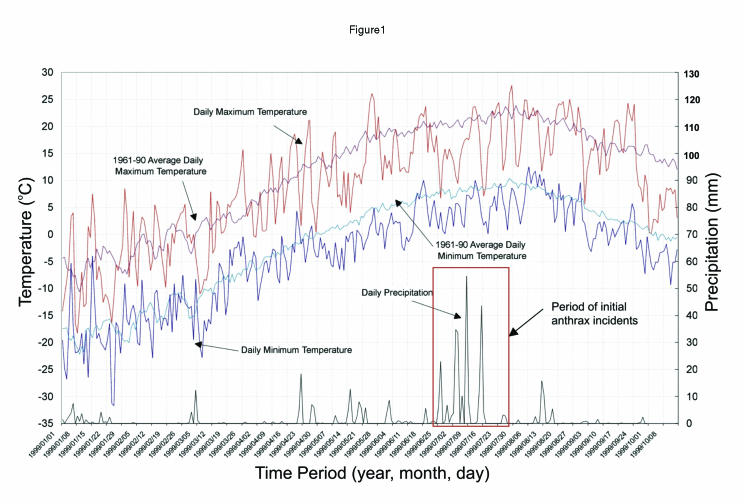
Anthrax outbreaks are commonly associated with old anthrax graves and certain weather patterns (3,4,5). This anthrax incident occurred after a long period of unusually warm and dry spring weather, which was followed by a heavy rainfall (Figure 1). The high temperatures during May and June may have facilitated the aggregation for multiplication of anthrax spores in the environment. During this long dry period, due to the shortage of grass, cattle may have been forced to graze closer to the soil and potentially become exposed to anthrax spores. The heavy rainfall may have also dispersed anthrax spores through natural drainage patterns.
Figure 1. Temperature and precipitation data for the anthrax infected area for the period January 1 to October 8, 1999.
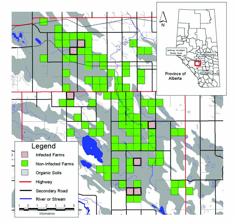
The findings of the study related to the comparison of the soils and drainage variables between the anthrax infected and non-infected farms were fairly significant. The majority of the anthrax-infected farms were situated on gleysolic and organic soils (Figure 2). It has been shown that the anthrax bacteria may be found in these types of moisture-laden soils. As well, the terrain of the land in this area presents itself as an undulating landform providing locations for low-lying areas of wetlands or standing water. Australian researchers reported that drainage conditions might be associated with a severe outbreak of anthrax reported on 83 properties in north central Victoria in Australia in 1997 (6). The survey indicated that the majority of infected farms reported that their cattle drank from standing water sources and that flooding and one or more land disruptions, such as clearing, breaking, or drainage modifications, which could unearth anthrax spores, had occurred within the last 5 to 10 y. As well, there is some speculation that spread of infection by insects, birds, scavengers, or other vectors may be possible due to the close proximity of the infected locations (3,4). Despite the apparent association between infected farms and factors such as drainage, flooding, and land disruption, there were other farms located within the same area that reported flooding, land disruption, or both and did not have anthrax cases. Timely implementation of control measures on infected farms and vaccination on non-infected farms may have stopped the spread of anthrax to these locations.
Figure 2. Location of anthrax infected and non-infected farms in the Horseguard Drainage area together with a distribution of organic soils.
A GIS provides an effective tool for input, storage, manipulation, and presentation of spatial data. In Canada, GIS technology has not been extensively applied in animal-related outbreak investigations because of cost; availability; format and compatibility of spatial databases; and, perhaps, even skepticism toward new technology. Our initial attempt to document and analyze an anthrax outbreak in Alberta by using a GIS provided the ability to integrate and analyze disparate databases and present data in a visual format. The quality of data collected and analyzed is a considerable factor in the results of a GIS study. In this case, more precise locations of pastures where infected cattle died in the outbreak area and a more rigid and comprehensive survey may have provided more conclusive findings. Despite these limitations, the use of a GIS was found to be a valuable tool to aid in the understanding of the physical characteristics of the anthrax outbreak area and in evaluating and documenting spatial descriptive patterns associated with the outbreak. Sporadic occurrence of anthrax over time and space may be expected in western Canada. Regulatory agencies may consider adopting GIS as a routine tool for the investigation and documentation of an anthrax outbreak. Furthermore, spatial data analysis provides a range of new techniques that may explain or predict future anthrax outbreaks.
Footnotes
Acknowledgments
The authors thank Dr. Jane Pritchard of the Western College of Veterinary Medicine; Dr. Doug Scott of the Canadian Food Inspection Agency; Ken Ziegler and Conny Tomas of Alberta Agriculture, Food and Rural Development; and Kim Nielsen of the Municipal District Clearwater for their constructive suggestions and support. We also thank Dr. Anne Deckert of the University of Guelph for reviewing our manuscript and providing us with useful comments and the participating cattle producers for completing the surveys. CVJ
Address all correspondence and reprint requests to Mr. Robert Parkinson; e-mail: parkinsonb@agr.gc.ca
References
- 1.Dragon DC, Elkin BT, Nishi JS, Ellsworth TR. A review of anthrax in Canada and implications for research on the disease in northern bison. J Appl Microbiol 1999;87:208–213. [DOI] [PubMed]
- 2.Anonymous. Guidelines for the surveillance and control of anthrax in humans and animals. 3rd ed. World Health Organization, Dept. of Communicable Disease Surveillance and Response 1999.
- 3.Hugh-Jones M. 1996–97 global anthrax report. J Appl Microbiol 1999;87:189–191. [DOI] [PubMed]
- 4.Dragon DC, Rennie RP. The ecology of anthrax spores: tough but not invincible. Can Vet J 1995;36:295–301. [PMC free article] [PubMed]
- 5.Gates CC, Elkin BT, Dragon DC. Investigation, control and epizootiology of anthrax in a geographically isolated, free-roaming bison population in Northern Canada. Canadian J Vet Res 1995; 59:256–264. [PMC free article] [PubMed]
- 6.Turner AJ, Galvin JW, Rubira RJ, Condron RJ, Bradley T. Experiences with vaccination and epidemiological investigations on an anthrax outbreak in Australia in 1997. J Appl Microbiol 1999;87:294–297. [DOI] [PubMed]


