Abstract
Terraces are traditional engineered ecosystems that affect the hydro-geological equilibrium, slope stability, and local communities. The aims of this paper are (i) identifying environmental factors that affect terrace stability in the Amalfi Coast, (ii) defining agriculturalists’ observations on environmental changes within that system and (iii) exploring potentiality of these observations to better define conservation strategies. All available data on physical and ecological factors recognized to affect the terrace system were collected and analyzed. Interviews were conducted with agriculturalists to obtain long-term observations on environmental factors that interact with this system. Landslides are more frequent where rainfall is high and during winter. Fires have an uneven annual distribution, with higher frequency during summers. Agriculturalists detailed complex interactions among environmental factors, economic elements, and terraces. These observations represent a valuable resource for defining causes and effects of abandonment and for better addressing conservation strategies.
Electronic supplementary material
The online version of this article (doi:10.1007/s13280-013-0433-3) contains supplementary material, which is available to authorized users.
Keywords: Cultural landscape, Engineered ecosystems, Local Ecological Knowledge
Introduction
Terraced agriculture is a cultural tradition in many ancient civilizations around the world (Lal 2001) with significant examples within the Mediterranean basin (Ruecker et al. 1998; Lasanta et al. 2001; Harfouche 2007; UNESCO 1997, 2007). Traditionally, terraces are built on sloping territories to obtain arable land. The construction of these terraces modifies the landscape, the hydro-geological equilibrium (Brancucci and Paliaga 2006) and the vegetation patterns, which change after abandonment (Blasi et al. 2000; Di Pietro and Filibeck 2000; Cancellieri 2008).
Traditional Mediterranean agro-landscapes are particularly threatened because of their modest profitability under current market conditions (Martınez-Fernandez et al. 2000) and declining interest in agriculture by younger generations. The interest in preserving these landscapes in Europe is testified by the development of some projects aimed at counteracting the abandonment of terraces [e.g., ALPTER project (http://www.alpter.net/); World terraced landscapes Alliance (Italy, http://www.paesaggiterrazzati.it/)].
One of the most well-conserved examples of terraced landscape can be found in the Amalfi Coast (Southern Italy), where terraces seem to date back to around the period of 950–1025 ad (Caneva and Cancellieri 2007). In this area, agriculture is still practiced using traditional methods but it is declining due to local economic shifts toward tourism. Consequently, conservation of agricultural terraces is often neglected, negatively impacting the control of subsiding phenomena (terrace collapse). The effectiveness of terraces, in mitigating erosion and land degradation, depends on proper construction, as well as regular maintenance (Lal 2001).
Terraces such as these of the Amalfi Coast may be considered human-engineered ecosystems and are typical examples of coupled natural-human systems. These systems are composed of many factors/units which interact in time and space (Pickett et al. 2005). In these systems, humans play a key role in decision making and management (Bolte et al. 2006).
Local Ecological Knowledge holders, as local farmers in the area, have deep understandings of complex environmental interactions (e.g., Gómez-Baggethun et al. 2012; Reedy et al. 2013). Although several studies have been carried out on local ecological knowledge systems, relatively few focused on landscape (Bridges and McClatchey 2009; Petheram et al. 2010) and land use (Ward et al. 2000; Frazier et al. 2010).
This research is situated in the context of the stimulating debate on the possible interface between this knowledge systems and science (Omura 2005; Wolf and Moser 2011). Moreover, this research builds on the work of Huntington et al. (2004) who suggest that matching local knowledge and scientific observations can provide a better understanding of environmental changes and their mechanisms since local knowledge usually incorporates adaptation strategies to deal with these changes which can be useful in environmental management and policy.
In this paper we discuss the idea, as proposed in Berkes and Berkes (2009) that local knowledge “pursues holism by considering a large number of variables qualitatively, while Western science tends to concentrate on a small number of variables quantitatively”. A multidisciplinary approach could be very useful in analyzing complex interactions in agro-ecosystems. Hopefully, this approach will help in understanding these complex interactions between humans and the environment.
Study Area
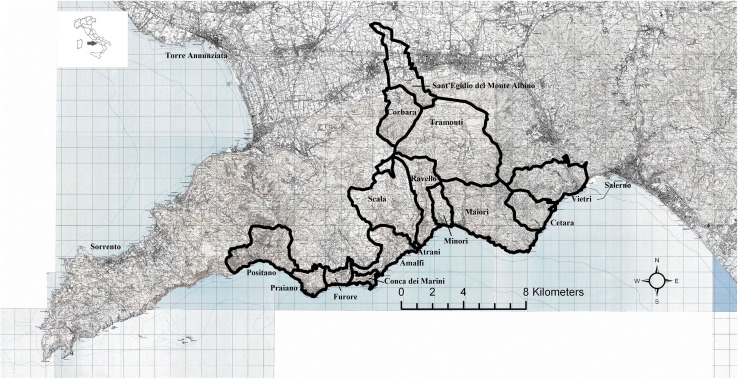
The Amalfi Coast UNESCO site constitutes the majority of the Sorrento Peninsula’s Southern side (Fig. 1). This area covers about 112.3 km2 defined by 40.38°–40.40° longitude and 14.29°–14.44° latitude. Almost the whole area is located within the “Monti Lattari” Regional Natural Park.
Fig. 1.
Geographical position of the study area with main cities and the names of the municipalities of the UNESCO site area
The outline of the Sorrento Peninsula is dominated by the Lattari Mountains characterized by high relief and steep slopes, made of fractured and karsified dolomite limestone of Mesozoic age (Di Crescenzo and Santo 2007). Pyroclastic deposits of coarse clasts are also unevenly distributed over the area (Caneva and Cancellieri 2007).
The area mainly has a Mediterranean climate with some sectors, at the highest altitudes, in the temperate belt. The area has very high rainfall in comparison with other Southern Italian coastal localities: mean annual rainfall averages are higher than 1000 mm, and sometimes higher than 1400 mm (Caneva and Cancellieri 2007).
The Amalfi Coast has a high floristic richness, leading to its particular vegetation diversity: following an altitudinal gradient, vegetation shifts from typical Mediterranean woodlands and shrublands to temperate woodlands in the upper areas (Caneva and Cancellieri 2007).
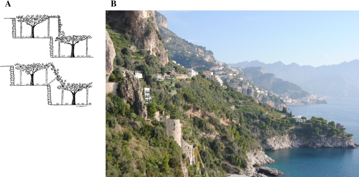
Terraces are typically dried stone structures (Fig. 2a, b), sometimes they are “a ripa” (with minimum slopes, steps are made of earth and covered by grass). The stones of the walls are not traditionally fixed with concrete.
Fig. 2.
a Schematic structure of stone-wall terraces in the Amalfi Coast (from Caneva and Cancellieri, 2007); b terraced landscape in the area. Terraces are traditionally built without using bonding materials
In 2001 (ISTAT 2001), the number of farms in the Amalfi Coast totaled 3,686 units with an average surface of 4400 m2 of Cultivated Land Surface. Vineyards account for the greatest surface area on the Coast (3.8 km2; ISTAT 2001). The second most important plant in cultivation is Citrus limon (L.) Osbeck, and in general, citrus orchards cover a surface of 3.7 km2 (ISTAT 2001). Lemon orchards are generally located at lower elevations while vineyards are predominant in the hilly belt (from 200 m up to around 500 m). Several crops are cultivated at higher altitudes, however, chestnut (Castanea sativa Mill.) cultivation becomes predominant there (Caneva and Cancellieri 2007).
Materials and Methods
The present analysis includes different methods which are detailed separately. The research process involved the following stages: conceptualization, data acquisition, and analysis.
Conceptualization
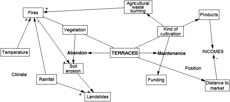
All environmental and economic factors hypothetically interacting within the system were integrated into a theoretical model (Fig. 3). The first step involved the elaboration of a causal diagram describing the main elements, their interactions, and the feedback processes related to the terrace system. Environmental factors and the human component were analyzed using different approaches. A set of hypotheses to test the causal role of each factor was expressed.
Fig. 3.
Proposed causal diagram of the terrace system of the Amalfi Coast illustrating the major components and their interactions. Correlations are based on ecological concepts in the literature and previous field studies in the area
Data Acquisition
Data on environmental elements (climate, landslides, fires, soil conditions, and vegetation) and on agriculturalists’ observations were obtained and analyzed using different methods, detailed separately below. The information available covers different time ranges and scales. Available data on land use and terraces were also collected.
Climate
Hypothesis: Climate has a role in affecting landslides, fires and the spatial distribution of plants (this influence is evident in vegetation serial evolution and in crop distribution).
Climatic data (average monthly daily values of rainfall and temperature) were collected at 28 gauging stations belonging to the National Meteorological Networks (Annali Idrologici 1959–1999). Climatic indicators were calculated as long-term averages of total monthly (and annual) precipitation and (mean, minimum, and maximum) temperature. Temperature and rainfall data were uploaded to ArcGis 9.2 and then spatialized using an ordinary kriging interpolation (Goovaerts 2000; Attorre et al. 2007).
Landslides
Hypothesis: Landslides are affected by soil erosion (also slope and vegetation cover), fires, and rainfall. Landslides affect terrace stability and vice versa.
It was possible to collect data on landslides registered from 1963 to 1998 (The AVI Project 2007). These data included locality, day, latitude, and longitude for the majority of events. Data on landslide events were computerized and overlaid on the rainfall distribution and soil erosion risk spatialization layers in ArcGis 9.2. Rainfall amounts of rainy days preceding landslides were also calculated.
Fires
Hypothesis: Fires are recognized to have an impact on vegetation, soil conditions, landslides, and land use. We considered that wild fires are affected by climate (aridity) and can be trigged by agricultural waste burning.
Fire event registrations have been obtained by the Regional Technical Provincial office for Forests in Caserta (unpublished). Data available cover a limited time span (1990–2003). Information available included: type of vegetation that burned down (e.g., forest, prairies), relative surface area, and very approximate position of fires. It was not possible to upload these data to a GIS database as precise locations of events were not available. The average monthly rainfall amount and average medium temperature registered at climatic gauging stations approximately closest to fires were also calculated. This calculation was made in order to highlight possible connections between fire occurrence and climate conditions.
Soil Erosion
Hypothesis: Soil erosion is related to fire occurrence, vegetation (non-cultivated grassland vegetation being the worst in protecting soil from erosion), and land use (cultivated areas are considered to have positive effects for soil protection); this element is recognized as contributing to landslides.
Soil data were obtained from a database of agricultural soil characteristics (Venezian Scarascia et al. 2006; Incerti et al. 2007), from 1:250 000 ecopedological and geological maps of Italy (Diodato and Ceccarelli 2004), and from an 800 m European soil quality map (Salvati et al. 2008). Soil erosion risk was evaluated using the Revised Universal Soil Loss Equation (RUSLE) (Montanarella 2007).
Vegetation and Land Use
Hypothesis: Vegetation types affect and are affected by both fires and soil conditions.
Terraces may be cultivated or abandoned, thus the cover could be represented by crops or by natural vegetation. Along the Amalfi Coast it is possible to approximate that all cultivated surfaces develop on terraces (excluding in the municipalities of Sant’Egidio del Monte Albino and Corbara, where the slope is minimal and terraces are rare). Thus we estimated the surface of cultivated terraces from the 1: 25 000 land use cover map (Caneva and Cancellieri 2007) which use CORINE IV coding (Bossard et al. 2000a, b; Buttner et al. 2002). Plant communities that grow on abandoned terraces were defined using field observations and bibliographic sources (Cancellieri 2008) to analyze the vegetation series (the likely evolution of one plant community into another) along the Amalfi Coast.
Terraces
Official records do not distinguish between terraces and other forms of cultivated land: we extrapolated their position locating all surfaces devoted to cultivation of grapes (CORINE IV code: 2.2.1), lemons (2.2.2.1), chestnuts (2.2.2.2), and olives (Olea europaea L.) (2.2.3). This extrapolation was made in ArcGIS 9.2. Neither the land use maps nor the extrapolated data reflect abandoned terraces or those that have already collapsed.
Interviews
A total number of 45 interviews were carried out between January and July 2012 with local farmers, land (terrace) owners, and orchardists in all municipalities of the UNESCO site (excluding the municipalities of Sant’Egidio del Monte Albino and Corbara). Information on perceptions of land use changes were collected through semi-structured interviews (Appendix S1 in Supplementary Material) with local people who have owned/cultivated the land (terraces) for at least 15 years. Besides these criteria, informants were randomly selected throughout the study area. Before starting interviews, informants were made aware of the scope of this study and Prior Informed Consent (Rosenthal 2006) was requested verbally. Interviews were conducted following International codes of Ethics. Personal data on informants (age, employment, place of residence, years of farming), field features (surface, type of terrace, cultivated crops), and changes in landscape/environment [reasons for abandonment, changes in landscape, fires, climate, observations on terrace failures (causes), etc.] were recorded.
Analysis of Data
The different raster files (and layers) of aforementioned maps were differently overlapped in order to explore the possible spatial correlations among the collected data, which were then used to establish the spatial relations of the main variables that interrelate within the model.
Data obtained by interviews were used to define a new causal diagram of the terrace system including all components reported by informants and their interactions.
Results
The hypothesized model (Fig. 3) includes six environmental factors [fire, landslide, vegetation, soil conditions, temperature, and rainfall (climate)] and several factors related to crop cultivation [cost of production (distance to market, manpower), public funding, and product price]. All of these factors interact with each other and may depend on human decision making (willingness to cultivate land or not). It is possible to consider unwillingness to continue cultivation as a choice that is dependent upon multiple factors. When the choice becomes one of abandonment, all of the physical factors interact in a path that returns terraces to a natural state, and thus susceptible to the rules of a natural ecosystem.
Climate
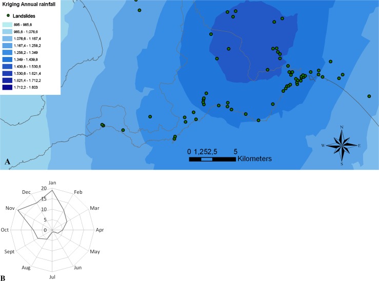
The output of the ordinary kriging interpolation and spatialization of annual rainfall is presented in Fig. 4a. Review of rainfall data shows that the rainiest season is winter. Figure 4a demonstrates that the rainiest area in the Coast is Tramonti. A negative trend in rainfall amount (especially during summer) was observed for the whole area starting from the 1980s (Caneva and Cancellieri 2007).
Fig. 4.
Landslides. a Spatial distribution of landslides in the Amalfi Coast (and nearby) overlaid to the kriging spatialization of annual rainfall (in mm). b Monthly distribution of landslides (number of events) in the Amalfi Coast during the considered time period. Landslides are more frequent over the rainiest months
Temperature values over winter are rarely so low that they could be considered limiting factors for plants. Temperature data, when available for a long time period, show a general increasing trend, with an evident increase starting in the 1980s. An increase of summer temperature values (especially minimum temperatures) was observed (Caneva and Cancellieri 2007). Increase in temperature and decrease in rainfall over the summer months have led to an increase in droughts, and drought stress for plants.
The majority of our informants (41 out of 45) observed multiple changes in climate conditions (Table 1). These changes started about 20–25 years ago. The majority of informants (31) observed changes in climate through their effects on plants, especially crop plants, and were generally able to correlate specific changes with defined effects (e.g., changes in ripening period, increase in pests, altitudinal shift of crop plants).
Table 1.
List of observations, causes, and effects of elements within the terrace system
| Observations | No. of informants | Effects | No. of informants | Causes | No. of informants |
|---|---|---|---|---|---|
| Climate | 41 | ||||
| Increase in temperature | 19 | Negatively affecting crops | 9 | ||
| Positively affecting weeds | 2 | ||||
| Increase in pests | 8 | ||||
| Increase in Summer drought | 10 | Negatively affecting crops | 10 | ||
| Increase in fires | 8 | ||||
| Negative effects on soil | 3 | ||||
| Indirect increase in labor costs | 2 | ||||
| Seasons are more unpredictable | 16 | Negatively affecting crops | 12 | ||
| Indirectly affecting market price | 1 | ||||
| Decrease in rainfall | 8 | ||||
| Changes in rainfall patterns | 8 | Increase in collapsed terraces/landslides | 3 | ||
| Increase in rainfall extreme events | 6 | Negatively affecting crops | 2 | ||
| Decrease in snowfall | 3 | Increase in pests | 1 | ||
| Increase in fog | 1 | ||||
| Fires | 45 | ||||
| Increase in fires | 23 | Increase in landslides | 2 | Humans (economic interests, creating pastures) | 14 |
| Summer drought | 8 | ||||
| Lack of woodland maintenance | 4 | ||||
| No changes | 16 | ||||
| Decrease in fires | 6 | ||||
| Landscape | 38 | ||||
| Increase in terrace abandonment | 24 | High labor input/costs | 10 | ||
| Distance from house and roads | 7 | ||||
| Low market prices of terrace products | 6 | ||||
| Property (family) problems | 3 | ||||
| Age | 2 | ||||
| Fires | 1 | ||||
| Wild boars | 1 | ||||
| Increase in houses (especially illegal) | 18 | ||||
| Changes in crop cultivation | 4 | ||||
| Increase in collapsed terraces/landslides | 3 | Heavy rainfall | 30 | ||
| Aged terrace walls/terraces (including water channels) not well maintained | 14 | ||||
| Vegetation growing on terrace walls | 4 | ||||
| Soil features | 2 | ||||
| Fires as indirect cause | 2 | ||||
| Changes in rain/drought cycles | 1 | ||||
| Changes in woodland surface | 2 | ||||
| Changes in species composition of woodland | 1 | ||||
| Increase in roadways | 1 | ||||
| Increase in non-traditional terraces (of concrete) | 1 |
Landslides
In the study area 75 landslides were registered between 1963 and 1998: only 9 of these were not preceded by rainy days. Sixteen landslides were preceded by slightly rainy days (up to 46.2 mm). All other landslide activities were preceded by several days of rather heavy rainfall, up to a maximum of 476.2 mm of rainfall in the 12 days before a flood that occurred in Tramonti in 1963. Several catastrophic landslides have been recorded in that same area since 1800, with effects spanning from heavy damages to buildings, to the death or dispersion of people (Budillon et al. 2005; Violante et al. 2006).
As it is possible to observe from Fig. 4a the majority of events occurred in areas where annual rainfall is higher than 1400 m, which is indicative of the Tramonti and Vietri areas. Our data show that the number of landslides is higher during November and January, which are the wettest times of the year (Fig. 4b).
According to a historical analysis (Cascini and Ferlisi 2002), starting from about 1500, in the Amalfi Coast, it was observed that larger landslides occurred during Autumn, while more localized landslides did not seem to have a marked periodicity. It is important to mention that smaller landslides were rarely registered before 1980 (Cascini and Ferlisi 2002), and despite an increase in their documentation it is very likely that their number continues to be under-estimated and under-reported.
The majority of our informants (27 out of 45) reported limited but also vast failures in their terraces. Their observations are not limited to their land but also of nearby properties and informants hypothesized an interaction of several factors as the causality of terrace failure. As highlighted in the literature (Calcaterra et al. 2000; Guadagno and Revellino 2005), landslides in close proximity are triggered by heavy rainfall and can be due to slope, soil features (and vegetation cover); in addition to this, our informants also observed other interacting factors (e.g., rainfall and a lack of terrace maintenance, which includes non-removal of vegetation growing on terrace walls and obstructing water channels). Many informants believe that if terraces are well maintained damage and failures can be limited or even avoided all together. A few informants also pointed to indirect effects such as an increase in fires affecting the vegetation cover. They related this loss of vegetation to the resulting barren soil, which rather than dispersing water across the terrace channels it, creating points of high pressure in the walls, ultimately leads to collapse.
Fires
The Mediterranean-type vegetation is one of the world’s major fire-prone biomes (Bond and Keeley 2005). In the areas in which this type of vegetation occurs, fire is a crucial process controlling vegetation dynamics and structure (Baeza et al. 2006; Capitanio and Carcaillet 2008). Fire could also lower the “tampon” capacity with repercussion on the stability of slope areas and thus, reduce the capacity for resilience (Dallari et al. 2006).
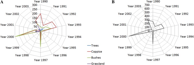
In the Amalfi Coast 395 fires were recorded in the period between 1990 and 2003 by local authorities. During this period, a total surface of (25.7 km2) was burned down. The number of fires for each year and surface (in m2) for each vegetation type are shown in Fig. 5a, b. The majority of fires (82.5 %) occurred between July and September, and only 1.5 % of fires occurred in June. Considering only the climatic gauging station closest to the fires, the average maximum temperature in June (24.9 °C) is very close to that of September (24.7 °C) but in June only a few fires were recorded (1.5 %) while several occurred in September (18 %). For the same gauging stations, the average rainfall registered in June is 34.2 mm and September is 98.4 mm. The rather high number of fires in September could be a result of drier summers leaving the soil and vegetation dry, both of which are perfect conditions for fire to spread (as a matter of fact, fires in August are more numerous than in July).
Fig. 5.
The number of fires for each year (a) and surface [in Ha = 10 000 m2) for each vegetation type (b) that burned down. Bushes are an intermediate in the vegetation evolution. Fires prevent the return to the forest stadium
The majority of our informants (33 out of 45) burn agricultural waste, generally in Autumn or Spring, never during the Summer, thus this management practice should not affect fires (contrary to our initial hypothesis). However, informants report discordant observations about fire frequency (Table 1). Several informants stated that the number of fires each year is variable (as it is also evident by Fig. 5a); moreover, they generally occur on the mountains, or on abandoned terraces (24), sometimes along the coast (1), never or only rarely close to houses or cultivated terraces. Finally, several informants believe that in the past fires occurred less often since terraces were all cultivated and forests were managed (branches and vegetation were collected from the woodland to feed cattle) and constitute a substantial resource (for lemon and grape stakes, lemon covering).
Soil Erosion
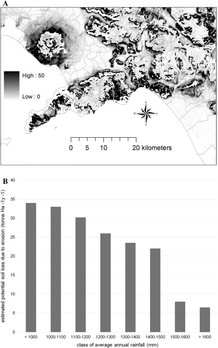
On the Amalfi Coast an average potential soil erosion of 25 000 kg × (0.01 km2 × year)−1 has been observed, according to the estimation provided by the RUSLE equation. However, the spatial distribution of potential soil erosion is not homogeneous over the study area ranging from nearly 6900 kg × (0.01 km2 × year)−1 to 39 700 kg × (0.01 km2 × year)−1 (Fig. 6a). Due to the varied morphology of the study area, it was also observed that higher potential soil loss rates, caused by erosion, occurred in areas with drier climate (i.e., rainfall below 1000 mm per year) but presumably more intense on a daily basis especially during autumn and spring, as reported in Fig. 6b.
Fig. 6.
a Erosion risk map, b the potential soil erosion estimated through RUSLE equation by class of annual average precipitation (1 tonne = 1000 kg; 1 Ha = 10 000 m2). Soil erosion risk under current climate trends will increase
Vegetation, Terraces, and Land Use
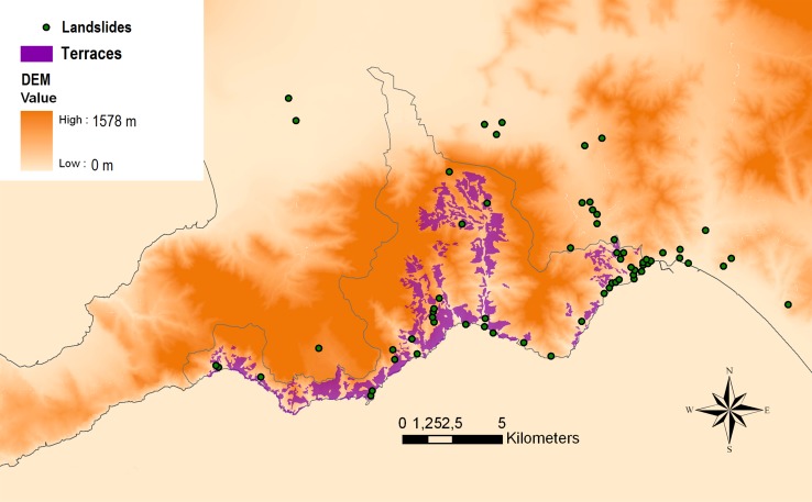
The majority of terraces develop from 50 m above sea level up to about 500 m, sometimes at higher altitudes, so they are generally present in the basal and hilly belts. The estimated surface area of terraces (Fig. 7) has been extrapolated by the land use map. However, it was not possible to define the surface and position of abandoned terraces since, over time, they are colonized by the same natural vegetation as other non-terraced areas.
Fig. 7.
Overlapping of cultivated terraces, landslides, and DEM. Cultivated terraces are more common at lower altitudes
The most important maintenance practice for terraces, according to almost all of our informants (44) is to remove vegetation from terrace walls. Vegetation is removed with different frequency (from once a month to once a year) and for reasons related both to wall stability and to cultivation: roots can damage the walls (14), keeping clean (14), diseases and animals (14), obstacle for passage (8), avoiding competition for light and nutrients (10), obstacle for water drainage (5), ignition source for fires (1).
Vegetation on terrace walls is positively retained only when terraces are made by earth (“a ripa”) rather than stone, as in this case grass roots are useful for stabilizing the soil. Farmers sometimes exploit the plants for other uses (manure, heating, fodder). Vegetation outside the terraces is not retained to have an impact on them, but agriculturalists sometimes observe natural phenomena also in the surrounding habitats.
Besides removing vegetation from terrace walls, other important practices for maintaining terraces as reported by our informants are: replacing fallen stones (24) and clearing water channels (3) of vegetation. Several informants (16) have abandoned their terraces, either entirely or in part; however, they generally perform maintenance practices to preserve the terrace structure. Of the informants that are still cultivating the land some (17) changed crops growing in their field, but the majority of informants (37) would not change their cultivated crops in the future.
The sum of the surface used for agriculture equals 22.7 % of the area; land use has changed over the last few decades: in several municipalities of the area woodland surface area has increased [shifted from 18.2 % (1954–1955) to 41 % (1998–1999) of the total surface], while agricultural land has decreased (from 42.1 % to 27 %) (Caneva and Cancellieri 2007). This decrease demonstrates an increase in abandoned terraces.
The majority of informants (38 out of 45) reported a change in landscape/land use (Table 1), as supported by other analyses.
Informants and Their Fields
Informants were predominately male (41 out of 45), with an average age of 63 years (Appendix S2 in Supplementary Material). Their duration of farming spans from 15 to 80 years (avg: 37.4). The main crops cultivated by informants are lemons and other citrus species (31 out of 45), vegetables (18) (especially for home consumption), grapes (14), chestnuts and other fruit trees (11), olives (8), and flowers (1) (some crops are intermixed in the field). Three informants breed animals (e.g., rabbits) on their terraces. Fields generally have a small surface area (averagely 10 000 m2).
Abandon Versus Maintenance
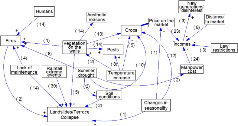
The information gathered with the interviews was used to define a new causal model of the terrace system (Fig. 8) where multiple factors and elements interact in creating a fragile equilibrium between abandonment and cultivation of terraces. This can be considered a qualitative model of a system where many environmental and socio-cultural elements interact, explaining causality of phenomena.
Fig. 8.
Causal diagram of the terrace system of the Amalfi Coast illustrating the components and interactions defined by informants. Numbers in brackets indicate the number of informants reporting the correlations. Relations among factors are more complex than we expected
The majority of informants (39 out of 45) reported that is not convenient to cultivate the land, but only a few of them stated that they would change their cultivation (8) in order to increase their profits. They want to cultivate traditional crops of the area, as lemons, and it is not possible to cultivate underneath lemons since they are evergreen and many believe that nothing would be convenient on terraces (costs of manpower, distance to market). Interestingly, two informants reported that breeding rabbits on terraces is convenient and does not require too much work.
The maintenance of terraces is motivated by tradition (3), keeping terraces tidy (1), avoiding landslides and terrace collapse (9). Most interviewed farmers are willing to continue orcharding; however, some (7) reported that their children will not continue cultivation of the land in the future.
Discussion
In the Mediterranean basin, industrialization and pressure from tourism activities during the last century led to an important socioeconomic change in rural areas, based on the abandonment of marginal terraced hillside soils in favor of cash crop cultivation of better soils in the plains, obtaining much higher net outputs (Puigdefabregas 1998). Nowadays, terraced agriculture has a marginal role in the economy of the Amalfi Coast, where farms generally have a limited surface area and are managed within the family unit. However, in the area, many terraces are currently not managed or abandoned.
Terraces can be considered as hydrological cells that control the distribution of water and soils at the slope and catchment scales. However, after decades of abandonment, these systems tend to collapse, losing the hydrological control provided by the terraces (Llovet et al. 2006; Dallari et al. 2006). In the Amalfi Coast many landslides occurred in the last decades (see also Progetto IFFI 2006), involving also terraces (Fig. 7). These failures are often caused and/or trigged by deep fractures in the rock mass and by heavy precipitation since the pyroclastic materials and deposits affect the water percolation (Cinque et al. 2000; Budillon et al. 2005). Changes in rainfall patterns and an increase of extreme rainfall events (as reported by informants) could increase the occurrence of landslides and terrace failures.
Changes in climate may affect soil erosion, especially for a change in the erosive power of rainfall (Pruski and Nearing 2002; Nearing et al. 2005). Soil erosion, in turn, may have additional and indirect effects on agriculture and crop management (Southworth et al. 2000; O’Neal et al. 2005), natural vegetation cover (Jiao et al. 2009 and references therein) and thus, on landslides. Climate change, indirectly, also has effects in landscape preservation: i.e., negatively affecting crops and agriculture and, as a consequence, increasing terrace abandonment.
Fire is the heaviest disturbance element of the terrace system even if it does not directly affect it; however, it could affect all of the other elements that are causes of terrace collapse. Fire risk increases after terrace abandonment, as fields are usually colonized by fire-prone plant communities (firstly grassland and then shrubland communities) following decreased human involvement. The dynamism of natural plant communities starts from prairies to garrigues, maquis and finally forests (e.g., Quercus ilex forest in the lower belt) so abandoned terraces in different stages of abandonment are subsequently colonized by different plant communities. Fires could interrupt and revert the natural dynamism of vegetation, leading also to soil erosion. Where fires are recurrent, soil erosion phenomena may be so heavy to lead to a semi-stable presence of Mediterranean prairies dominated by Ampelodesmos mauritanicus (Poir.) T. Durand & Schinz and Hyparrhenia hirta (L.) Stapf. These prairies frequently colonize abandoned terraces when fires occur repeatedly (Cancellieri 2008).
Fires reduce plant cover (Neary et al. 1999; Certini 2005), leaving the soil surface unprotected. Furthermore, lack of vegetation cover could impact the landscape and affect slope stability as it could increase the risk of landslide during heavy rainfall events.
Therefore, soil degradation processes in these landscapes can be enhanced by the combined effect of terrace collapse and fire (Llovet et al. 2006).
The major problem about re-colonization of terraces is due to plants that start to grow on the walls, especially phanerophytes and nano-phanerophytes as they quickly impact the walls’ mechanical stability. Roots penetrate deeply into fractures and cause mechanical stress from both their growth and chemical damage due to exudate emission (Caneva et al. 2009). The restoration of terraces may become even more difficult, and it could be necessary to partially dismantle the structure in order to remove roots which have become embedded in the walls.
Several informants reported that few people, or even none, remain who are still able to repair or build traditional terraces using only dry stones. There is a lot of concern about the use of concrete since it does not assure an acceptable flow of the water. Terrace structures are seldom managed if the land is abandoned, while the reconstruction of terraces is very expensive and regulated by law.
Considering all these factors and problems, periodical maintenance of terraces seems to be the most effective (and less expensive) landscape conservation strategy. Periodical removal of vegetation from the walls is the crucial practice (according to informants), for preserving the static equilibrium of structures. Several informants cultivate their land only as hobby or side activity since incomes from agriculture are not enough to make a living. Tourism inputs have been proposed in other areas for contributing in the preservation of terraces (e.g., Liguria) but in Amalfi tourism is disentangled by agriculture. Increasing agro-touristic activities, intercropping and diversifying crops or activities (as breeding rabbits), could be possible solutions to increase incomes for farmers and subsidize the maintenance of terraces and of the cultural landscape of the Amalfi Coast.
Conclusions
This research provides a simple method in exploring the human dimension of terraces as human-engineered ecosystems that greatly depend on humans for their maintenance over time. Fires, climate, vegetation dynamics, market demands, production costs, etc., govern the terrace system equilibrium. Data on environmental factors were not always available or comparable over time frames or space. Nevertheless, it was possible to better define factors that interact within the terrace system, using agriculturalists’ observations. The main findings of our study are:
Environmental physical data sometimes cannot show or explain environmental (complex) processes—this is especially true if humans are somehow integrated in this process.
Agriculturalists were able to identify environmental factors that affect terraces and how they are interacting (indeed these factors were more than hypothesized).
Agriculturalists’ observations were useful to define the most critical problems for terrace maintenance and stability, and factors that could affect the decision making and willingness to cultivate the land.
Conservation strategies that have been implemented locally are generally more likely to be accepted and be effective. Solutions provided by informants can be useful in managing these fragile systems in other parts of the world, but also this integrated approach could be used for coupled natural-human ecosystems in general.
Electronic supplementary material
List of questions for the interviews with local agriculturists (PDF 17 kb)
Position of the interviews and summary of the information on informants (PDF 121 kb)
Acknowledgments
We would like to thank the “Comunità Montana Monti Lattari” for supporting this research within the project “La valorizzazione delle specie vegetali tipiche della Costiera amalfitana con potenzialità economiche”.
Biographies
Valentina Savo
is a postdoctoral researcher at Simon Fraser University. Her research focuses on human–environment relationships and includes ethnobotany, TEK, and environmental changes.
Giulia Caneva
is a full professor at University Roma Tre. Her research interests include ethnobotany, Mediterranean vegetation, and cultural heritage protection.
Will McClatchey
is the Vice director and Director of Research of the Botanical Research Institute of Texas. His research addresses hypotheses about the evolution of patterns of human interactions with plants and ecosystems.
David Reedy
is a researcher at the Botanical Research Institute of Texas, and a doctoral student at the University of Hawai`i at Mānoa. His research focuses on human/cultural interactions with their environment and changing climates.
Luca Salvati
is a permanent researcher at the Italian National Agricultural Research Council in Rome, Italy. His research interests include land degradation, climate changes, land-use changes, rural geography, and sustainable development.
Contributor Information
Valentina Savo, Phone: 001-778-782-9235, FAX: 001-778-782-9235, Email: vsavo@sfu.ca.
Giulia Caneva, Email: caneva@uniroma3.it.
Will McClatchey, Email: wmcclatchey@brit.org.
David Reedy, Email: reedy@hawaii.edu.
Luca Salvati, Email: luca.salvati@entecra.it.
References
- Annali Idrologici. 1959–1999. Watersheds of the Tyrrhenian sector between Garigliano and Bussento and between Noce and Garigliano. Presidenza del Consiglio dei Ministri, Servizi Tecnici Nazionali (in Italian).
- Attorre F, Alfo M, De Sanctis M, Francesconi F, Bruno F. Comparison of interpolation methods for mapping climatic and bioclimatic variables at regional scale. International Journal of Climatology. 2007;27:1825–1843. doi: 10.1002/joc.1495. [DOI] [Google Scholar]
- Baeza MJ, Raventós J, Escarré A, Vallejo VR. Fire risk and vegetation structural dynamics in Mediterranean shrubland. Plant Ecology. 2006;187:189–201. doi: 10.1007/s11258-005-3448-4. [DOI] [Google Scholar]
- Berkes F, Berkes MK. Ecological complexity, fuzzy logic, and holism in indigenous knowledge. Futures. 2009;41:6–12. doi: 10.1016/j.futures.2008.07.003. [DOI] [Google Scholar]
- Blasi C, Di Pietro R, Fortini P. A phytosociological analysis of abandoned terraced olive grove shrublands in the Tyrrhenian district of Central Italy. Plant Biosystems. 2000;134:305–331. doi: 10.1080/11263500012331350475. [DOI] [Google Scholar]
- Bolte JP, Hulse DW, Gregory SV, Smith C. Modeling biocomplexity—Actors, landscapes and alternative futures. Environmental Modelling & Software. 2006;22:570–579. doi: 10.1016/j.envsoft.2005.12.033. [DOI] [Google Scholar]
- Bond WJ, Keeley JE. Fire as a global ‘herbivore’: The ecology and evolution of flammable ecosystems. Trends in Ecology & Evolution. 2005;20:387–394. doi: 10.1016/j.tree.2005.04.025. [DOI] [PubMed] [Google Scholar]
- Bossard, M., J. Feranec, and J. Othael. 2000a. CORINE land cover technical guide—Addendum 2000. Technical report no. 40. European Environment Agency.
- Bossard, M., J. Feranec, and J. Othael. 2000b. The revised and supplemented Corine land cover nomenclature. Technical report no. 38. European Environment Agency.
- Brancucci, G., and G. Paliaga. 2006. The hazard assessment in a terraced landscape: preliminary result of the Liguria (Italy) case study in the Iterreg III Alpter Project. In Proceedings of the conference on geohazards, ed. F. Nadim, R. Pottler, H. Einstein, H. Klapperich, and S. Kramer, Paper no. 16. Lillehammer, Norway.
- Bridges KW, McClatchey WC. Living on the margin: Ethnoecological insights from Marshall Islanders at Rongelap atoll. Global Environmental Change. 2009;19:140–146. doi: 10.1016/j.gloenvcha.2009.01.009. [DOI] [Google Scholar]
- Budillon F, Violante C, Conforti A, Esposito E, Insinga D, Iorio M, Porfido S. Event beds in the recent prodelta stratigraphic record of the small flood-prone Bonea Stream (Amalfi Coast, Southern Italy) Marine Geology. 2005;222–223:419–441. doi: 10.1016/j.margeo.2005.06.013. [DOI] [Google Scholar]
- Buttner, G., J. Feranec, and G. Jaffrain. 2002. Corine land cover Update 2000. Technical guidelines. Technical Report no. 89. European Environment Agency.
- Calcaterra, D., M. Parise, B. Palma, and L. Pelella L. 2000. The influence of meteoric events in triggering shallow landslides in pyroclastic deposits of Campania, Italy. In Proceedings of the 8th international symposium on landslides, ed. E. Bromhead, N. Dixon, and M.L. Ibsen, 209–214. Cardiff: AA Balkema.
- Cancellieri, L. 2008. Study on the vegetation dynamics on the Lattari Mountains (Campania). PhD thesis, Rome: University Roma Tre (in Italian).
- Caneva G, Cancellieri L. Vegetation landscape of the Amalfi Coast. Rome: Gangemi Ed; 2007. [Google Scholar]
- Caneva G, Galotta G, Cancellieri L, Savo V. Tree roots and damages in the Jewish catacombs of Villa Torlonia (Roma) Journal of Cultural Heritage. 2009;10:53–62. doi: 10.1016/j.culher.2008.04.005. [DOI] [Google Scholar]
- Capitanio R, Carcaillet C. Post-fire Mediterranean vegetation dynamics and diversity: A discussion of succession models. Forest Ecology and Management. 2008;255:431–439. doi: 10.1016/j.foreco.2007.09.010. [DOI] [Google Scholar]
- Cascini, L., and S. Ferlisi. 2002. Historical data of landslides in the Amalfi Coast. Incontro Annuale dei Ricercatori di Geotecnica—IARG 2002.
- Certini G. Effects of fire on properties of forest soils: A review. Oecologia. 2005;43:1–10. doi: 10.1007/s00442-004-1788-8. [DOI] [PubMed] [Google Scholar]
- Cinque A, Robustelli G, Russo M. The consequences of pyroclastic fallout on the dynamics of mountain catchments: Geomorphic events in the Rivo D’Arco basin (Sorrento Peninsula, Italy) after the plinian eruption of Vesuvius in 79 AD. Geografia Fisica e Dinamica Quaternaria. 2000;23:117–129. [Google Scholar]
- Dallari, D., C. Iadanza, A. Trigila, I. Rischia, and F. Fumanti. 2006. Slope stability and vegetation cover ecological efficiency. Paper presented at the European Geoscience Union General Assembly, Wien, Austria, 02–07 April 2006.
- Di Crescenzo G, Santo A. High-resolution mapping of rock fall instability through the integration of photogrammetric, geomorphological and engineering–geological surveys. Quaternary International. 2007;171:118–130. doi: 10.1016/j.quaint.2007.03.025. [DOI] [Google Scholar]
- Di Pietro R, Filibeck G. Abandoned terraces and colonization of natural vegetation: The case study of M.ti Aurunci. Informatore Botanico Italiano. 2000;32:17–30. [Google Scholar]
- Diodato N, Ceccarelli M. Multivariate indicator kriging approach using a GIS to classify soil degradation for Mediterranean agricultural lands. Ecological Indicators. 2004;4:177–187. doi: 10.1016/j.ecolind.2004.03.002. [DOI] [Google Scholar]
- Frazier TG, Wood N, Yarnal B. Stakeholder perspectives on land-use strategies for adapting to climate-change-enhanced coastal hazards: Sarasota, Florida. Applied Geography. 2010;30:506–517. doi: 10.1016/j.apgeog.2010.05.007. [DOI] [Google Scholar]
- Gómez-Baggethun E, Reyes-García V, Olsson P, Montes C. Traditional ecological knowledge and community resilience to environmental extremes: A case study in Doñana, SW Spain. Global Environmental Change. 2012;22:640–650. doi: 10.1016/j.gloenvcha.2012.02.005. [DOI] [Google Scholar]
- Goovaerts P. Geostatistical approaches for incorporating elevation into the spatial interpolation of rainfall. Journal of Hydrology. 2000;228:113–129. doi: 10.1016/S0022-1694(00)00144-X. [DOI] [Google Scholar]
- Guadagno FM, Revellino P. Debris avalanches and debris flows of the Campania Region (southern Italy) Debris-flow Hazards and Related Phenomena. 2005;2005:489–518. doi: 10.1007/3-540-27129-5_19. [DOI] [Google Scholar]
- Harfouche, R. 2007. History of the Mediterranean terraced landscape: Development and agriculture. Oxford: Archaeopress (in French).
- Huntington H, Callaghan T, Fox S, Krupnik I. Matching traditional and scientific observations to detect environmental change: A discussion on Arctic terrestrial ecosystems. AMBIO. 2004;2004:18–23. [PubMed] [Google Scholar]
- Incerti G, Feoli E, Giovacchini A, Salvati L, Brunetti A. Analysis of bioclimatic time series and their neural network-based classification to characterize drought risk patterns in south Italy. International Journal of Biometeorology. 2007;51:253–263. doi: 10.1007/s00484-006-0071-6. [DOI] [PubMed] [Google Scholar]
- ISTAT. 2001. Agriculture census. Retrieved 20 November, 2011, from http://www.census.istat.it/wibdsi/default.asp (in Italian).
- Jiao J, Zou H, Jia Y, Wang N. Research progress on the effects of soil erosion on vegetation. Acta Ecologica Sinica. 2009;29:85–91. doi: 10.1016/j.chnaes.2009.05.001. [DOI] [Google Scholar]
- Lal R. Managing world soil for food security and environmental quality. In: Sparks DL, editor. Advances in agronomy. New York: Academic Press; 2001. [Google Scholar]
- Lasanta T, Arnáez J, Oserín M, Ortigosa LM. Marginal lands and erosion in terraced fields in the Mediterranean mountains: A case study in the Camero Viejo (Northwestern Iberian System, Spain) Mountain Research and Development. 2001;21:69–76. doi: 10.1659/0276-4741(2001)021[0069:MLAEIT]2.0.CO;2. [DOI] [Google Scholar]
- Llovet J, Mayor AG, Bautista S, Bellot J, Vallejo VR. Scale relationships in the hydrological and erosional response to fire in a Mediterranean terraced landscape. Geophysical Research Abstracts. 2006;8:10470. [Google Scholar]
- Martınez-Fernandez J, Esteve-Selma MA, Calvo-Sendın JF. Environmental and socioeconomic interactions in the evolution of traditional irrigated lands: A dynamic system model. Human Ecology. 2000;28:279–299. doi: 10.1023/A:1007024204961. [DOI] [Google Scholar]
- Montanarella L. Trends in land degradation in Europe. In: Sivakumar MV, Ndiangui N, editors. Climate and land degradation. Berlin: Springer; 2007. [Google Scholar]
- Nearing MA, Jetten V, Baffaut C, Cerdan O, Couturier A, Hernandez M, Le Bissonnais Y, Nichols MH, et al. Modeling response of soil erosion and runoff to changes in precipitation and cover. Catena. 2005;61:131–154. doi: 10.1016/j.catena.2005.03.007. [DOI] [Google Scholar]
- Neary DG, Klopatek CC, de Bano LF, Folliott PF. Fire effects on belowground sustainability: A review and synthesis. Forest Ecology and Management. 1999;122:51–71. doi: 10.1016/S0378-1127(99)00032-8. [DOI] [Google Scholar]
- Omura K. Science against modern science: The socio-political otherness in Inuit TEK (traditional ecological knowledge) Senri Ethnological Studies. 2005;67:323–344. [Google Scholar]
- O’Neal MR, Nearing MA, Vining RC, Southworth J, Pfeifer RA. Climate change impacts on soil erosion in Midwest United States with changes in crop management. Catena. 2005;61:165–184. doi: 10.1016/j.catena.2005.03.003. [DOI] [Google Scholar]
- Petheram L, Zander KK, Campbell BM, High C, Stacey N. ‘Strange changes’: Indigenous perspectives of climate change and adaptation in NE Arnhem Land (Australia) Global Environmental Change. 2010;20:681–692. doi: 10.1016/j.gloenvcha.2010.05.002. [DOI] [Google Scholar]
- Pickett STA, Cadenasso ML, Grove JM. Biocomplexity in coupled natural-human systems: A multidimensional framework. Ecosystems. 2005;8:225–232. doi: 10.1007/s10021-004-0098-7. [DOI] [Google Scholar]
- Progetto IFFI. 2006. http://www.isprambiente.gov.it/it/progetti/iffi-inventario-dei-fenomeni-franosi-in-italia.
- Pruski FF, Nearing MA. Climate-induced changes in erosion during the 21st century for eight U.S. locations. Water Resources Research. 2002;38:1298. doi: 10.1029/2001WR000493. [DOI] [Google Scholar]
- Puigdefabregas, J. 1998. Implications of regional scale policies on land condition and land degradation in the Mediterranean basin. In Global change and terrestrial ecosystems. The Earth changing land. GCTE-LUCC, Open Science Conference on Global Change, GCTE, Barcelona.
- Reedy D, Savo V, McClatchey W. Traditional climatic knowledge: Orchardists’ perceptions of and adaptation to climate change in the Campania region (Southern Italy) Plant Biosystems. 2013 [Google Scholar]
- Rosenthal JP. Politics, culture, and governance in the development of prior informed consent in indigenous communities. Current Anthropology. 2006;47:119–142. doi: 10.1086/497670. [DOI] [PMC free article] [PubMed] [Google Scholar]
- Ruecker G, Schad P, Alcubilla MM, Ferrer C. Natural regeneration of degraded soils and site changes on abandoned agricultural terraces in Mediterranean Spain. Land Degradation and Development. 1998;9:179–188. doi: 10.1002/(SICI)1099-145X(199803/04)9:2<179::AID-LDR276>3.0.CO;2-R. [DOI] [Google Scholar]
- Salvati L, Petitta M, Ceccarelli T, Perini L, Di Battista F, Venezian Scarascia ME. Italy’s renewable water resources as estimated on the basis of the monthly water balance. Irrigation and Drainage. 2008;57:507–515. doi: 10.1002/ird.380. [DOI] [Google Scholar]
- Southworth J, Randolph JC, Habeck M, Doering OC, Pfeifer RA, Gangadhar Rao D, Johnston JJ. Consequences of future climate change and changing climate variability on maize yields in the midwestern United States. Agriculture, Ecosystems & Environment. 2000;82:139–158. doi: 10.1016/S0167-8809(00)00223-1. [DOI] [Google Scholar]
- The AVI Project. 2007. An inventory of areas affected by landslides and floods in Italy. Retrieved 1 December, 2011, from http://avi.gndci.cnr.it/welcome_en.htm.
- UNESCO. 1997. Convention concerning the protection of the World Cultural and Natural Heritage. World Heritage Committee, 21st session.
- UNESCO. 2007. Convention concerning the protection of the World Cultural and Natural Heritage. World Heritage Committee, 31st session.
- Venezian Scarascia ME, Di Battista F, Salvati L. Water resources in Italy: Availability and agricultural uses. Irrigation and Drainage. 2006;55:115–127. doi: 10.1002/ird.222. [DOI] [Google Scholar]
- Violante C, Sacchi M, Tesauro A, Thot T, Vittori E. The 25–26 October 1954 hyperpycnal flow at Bonea stream mouth (Amalfi Coast, Southern Italy): New data from ultra-high resolution acoustic surveys. Geophysical Research Abstracts. 2006;8:10589. [Google Scholar]
- Ward D, Ngairorue BT, Apollus A, Tjiveze H. Perceptions and realities of land degradation in arid Otjimbingwe, Namibia. Journal of Arid Environments. 2000;45:337–356. doi: 10.1006/jare.2000.0647. [DOI] [Google Scholar]
- Wolf J, Moser SC. Individual understandings, perceptions, and engagement with climate change: Insights from in depth studies across the world. Wiley Interdisciplinary Reviews: Climate Change. 2011;2:547–569. [Google Scholar]
Associated Data
This section collects any data citations, data availability statements, or supplementary materials included in this article.
Supplementary Materials
List of questions for the interviews with local agriculturists (PDF 17 kb)
Position of the interviews and summary of the information on informants (PDF 121 kb)


