

Abstract
Ancient societies are often used to illustrate the potential problems stemming from unsustainable land-use practices because the past seems rife with examples of sociopolitical “collapse” associated with the exhaustion of finite resources. Just as frequently, and typically in response to such presentations, archaeologists and other specialists caution against seeking simple cause-and effect-relationships in the complex data that comprise the archaeological record. In this study we examine the famous case of Chaco Canyon, New Mexico, during the Bonito Phase (ca. AD 860–1140), which has become a prominent popular illustration of ecological and social catastrophe attributed to deforestation. We conclude that there is no substantive evidence for deforestation at Chaco and no obvious indications that the depopulation of the canyon in the 13th century was caused by any specific cultural practices or natural events. Clearly there was a reason why these farming people eventually moved elsewhere, but the archaeological record has not yet produced compelling empirical evidence for what that reason might have been. Until such evidence appears, the legacy of Ancestral Pueblo society in Chaco should not be used as a cautionary story about socioeconomic failures in the modern world.
Keywords: societal collapse, geochemical sourcing, GIS, least-cost pathways
Deforestation is modern global problem resulting in habitat loss, erosion, pollution, and potentially negative climate impacts that eventually may have catastrophic economic consequences. When deforestation is ascribed to preindustrial or archaeological contexts, the focus usually is on unsustainable economic practices precipitating some sort of catastrophe or societal “collapse” (1, 2). However, although the causes of modern deforestation are easily observed and future impacts can be readily imagined, the difficulties in linking the archaeological evidence for tree use with destructive economic consequences present a serious challenge to the popularized portrayals of prehistoric societies as exemplars of the consequences of profligate behavior.
Consider the case of Chaco Canyon, in northwest New Mexico (Fig. 1), during the Bonito Phase (ca. AD 860–1140), a period of emergent social complexity in pre-European North America characterized by the rapid development of a hierarchical society engaged in intensive agriculture, long-distance exchange, and regional political control over smaller communities. The iconic feature of the Bonito Phase is the “great house,” a large masonry building assumed to have been the center of local communities and a focus of communal religious activity (Fig. 2 and Fig. S1). Thousands of timber elements were used in great house construction, and it is widely believed that much of this wood was imported from sources far outside the canyon, perhaps 80 km away, because there were not enough local trees suitable for building, partly or wholly a result of deforestation by local residents (3–5). The acquisition of costly timber may have signaled the sociopolitical power of those who organized these efforts (6), but some scholars argue that reliance on external resources was unsustainable and led to societal collapse (1).
Fig. 1.

Location of Chaco Canyon (at arrow origin) in the San Juan Basin of northwest New Mexico and the distribution of great houses and strontium isotope samples discussed in the text.
Fig. 2.
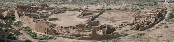
Pueblo Bonito located in the cluster of Chaco great houses that defined “downtown Chaco.” The earliest section of the structure was built in the mid-ninth century AD. Additions were added later, mainly in the middle to late 11th century AD, eventually creating a building with more than 600 rooms and up to four stories in some sections. Occupation of the structure continued through the 13th century AD.
In collapse scenarios local deforestation at Chaco was the result of harvesting trees for fuel and construction (7, 8), which in turn caused erosion and the destruction of agricultural fields, undermining local food production and forcing residents to offset these losses through imports (1). Declines in local productivity were managed by a compensatory reliance on an elaborate but unstable regional exchange system that failed during periods of widespread drought, particularly in the 12th century AD, ultimately leading to canyon abandonment. The conclusion that Chaco’s abandonment was self-induced by destructive resource use has been promoted as a warning for modern societies about pursuing short-term growth over long-term sustainability (1, 2).
This cautionary story about decisions or choices leading to an avoidable social catastrophe has reached vast nonarchaeological audiences, presenting the Bonito Phase as a thinly veiled Eden-like scenario (1). Nevertheless, there is no direct evidence for human impacts on local woodlands during the Bonito Phase, no indication that agricultural fields were destroyed by deforestation or any other process, and, surprisingly, no conclusive information about the amount and sources of archaeological wood. Indeed, Chaco residents had available sources of timber and other natural resources that were certainly less costly than the distant resources that are critical to collapse models. Here we examine the uncertainty surrounding arguments for the impact of deforestation on Chaco society and present an analytical approach to estimating timber acquisition costs that suggests a less fragile exchange economy than hypothesized by proponents of the unsustainable resource management scenario.
Background
Pueblo Bonito was the physical and social center of a large community comprising multiple great houses and perhaps hundreds of smaller buildings, hierarchically organized to manage social relations, food production, and regional exchange effectively (9, 10). Most great house building in Chaco took place during the 11th century AD (3, 11), but depopulation appears to have started soon afterward and was complete by the late 13th century AD.
The idea that depopulation was caused by deforestation that led to erosion and, as a result, to declining agricultural productivity is an old one, dating to the early 20th century (12–14), although evidence for deforestation was circumstantial, consisting mainly of a few living trees in the canyon and scattered dead ponderosa pine (Pinus ponderosa). Archaeologists speculated that that tree harvesting left soils exposed and susceptible to erosion during drought, thus reducing agricultural yields. This suggestion never was substantiated and did not have much influence on explanatory models for the Bonito Phase until a study of fossil packrat nests in the early 1980s.
Researchers investigated fossil packrat (Neotoma sp.) nests in Chaco by inventorying the constituent plant species, radiocarbon dating some of the nest contents, and reconstructing likely plant communities at different points in time (7, 8). They concluded that a major reduction of pinyon (Pinus sp.) occurred between ca. AD 800–1150 and was more likely to have been a consequence of “relentless woodcutting” than of natural causes such as climate change (ref. 7, p. 658). The unsustainability model popularized by other scholars (1, 2) asserts that the packrat midden studies demonstrated conclusively that human residents were responsible for depletion of local woodlands.
However, although packrat researchers proposed a cultural explanation for inferred reductions in pinyon, they did not present independent empirical confirmation for this hypothesis and were unable to offer a method for directly evaluating the alternative (or tandem) role of climate effects on canyon vegetation (8). Pinyon-juniper woodlands are highly sensitive to increases in aridity and temperature (15), and several major episodes of drought occurred in the San Juan Basin between AD 200 and 1300 (16, 17); therefore disentangling cultural and natural impacts on local vegetation in Chaco remains an important but unresolved problem.
Pollen records for Chaco have been interpreted as indicating only scattered trees along cliffs and escarpments above the canyon rather than woodlands within the canyon at any time in the past 2,000 y (18–20). Indeed, packrat investigators could not estimate prehistoric tree density in the canyon before the Bonito Phase (8) and subsequently acknowledged that the deforestation interpretation was subject to ongoing debate (21), particularly given that packrat nests provide information only about the presence or absence of vegetation types in highly localized settings and should not be taken as reflections of broader ecological structure (19, 22).
Only two radiocarbon samples from packrat middens dated to the entire prehistoric ceramic occupation of the canyon (ca. AD 500–1300), and neither was obtained from the area around Pueblo Bonito and surrounding great houses (Fig. 3 and Fig. S2). Although researchers attributed the paucity of dated material to tree-cutting, the decline in dated nests may reflect an absence of packrats, not necessarily an absence of trees. High rates of predation by the human population is a potential explanation for few dated nests and is consistent with archaeological and historical data for human consumption of packrats in the northern Southwest (23, 24). Increases in temperature and aridity also may result in the extirpation of a local packrat population (25).
Fig. 3.

Great house locations in the Chaco Core, local named tributaries, and the locations of strontium isotope samples discussed in the text.
Consequently, it is possible that there were no local woodlands to deforest by the onset of the Bonito Phase in the AD 900s (26), perhaps because human populations in the canyon had already depleted local tree resources (or packrats) by ca. AD 400. Reconstructing the vegetation history of Chaco obviously is a complex issue; our point is simply that the packrat data do not provide a reliable guide to human behavior before or during the Bonito Phase and therefore cannot offer conclusive support for human-caused deforestation.
Fuel use frequently is invoked as a leading cause of deforestation in Chaco (27) including the assertion that the “exhaustion of local firewood supplies” forced residents to seek fuel outside the canyon and prevented them from making their own pottery, because “all late-period pottery in Chaco Canyon was imported” (ref. 1, p. 149). This assertion is not supported by the empirical record, because at most 50% of grayware cooking vessels (utility wares) were obtained from sources to the west of Chaco during the late AD 1000s, a percentage that is similar to that in sites elsewhere in the San Juan Basin, including those closer to modern timber sources (28). The highest estimate for potential overall import of pottery is ca. 50% in the mid-12th century AD, and this estimate is uncertain. (29). Experts recognize that exchange may have been driven by factors other than fuel availability and that local production probably continued throughout the Bonito Phase (29). Therefore, Chaco ceramics do not reveal anything reliable about fuel consumption in the canyon during the Bonito Phase.
National Park Service researchers in the 1970s quantified fuel use from charcoal recovered as primary deposits in heating features or hearths or as secondary deposits associated with trash (30). They found that fuel from all times periods was dominated by shrubby plant species such as Atriplex and Artemisa, not trees. Dried maize cobs are actually one of the most common types of fuel debris found in Chaco sites, but they are fragile and less likely to be preserved than wood charcoal; therefore their importance is generally underestimated. In other words, there is evidence that residents had access to fuel throughout the canyon occupation but there is no indication that canyon residents were very reliant on trees for fuel at any time.
Likewise, we are unaware of any scientific investigation in Chaco that has produced physical evidence for the destruction of arable lands in the 12th century (17, 20, 31), as hypothesized by early researchers and promoted recently by others (1, 2). It has been suggested that if water tables dropped during the earlier 10th century, potential food production on the north side of the canyon (Fig. 3) would have been diminished, and farmers therefore might have been more reliant on capturing surface runoff further upstream from entrenched areas and in fact, may have compensated for the reduced water supply by increasing the complexity of local water-control systems (17, 32). Although prolonged dry periods must have had significant economic consequences for Chaco society, researchers have not argued that food production in the canyon ever became “impossible,” as assumed in collapse models (ref. 1, p. 153), and the paleoclimate record provides no obvious correlation between drought and societal collapse (4, 17). On the contrary, construction patterns indicate that overall energy investment in Chaco great houses began to decline in the late AD 1000s, before the onset of any documented drought periods (33), and immigrants appear to have arrived in Chaco during the 12th century drought (34).
The original Chaco deforestation hypothesis focused exclusively on the reduction of local stands of ponderosa pine (rather than pinyon pine and juniper) to provide the large timber elements required for building multiple-story, free-standing great houses. Subsequently, dendrochronologists recognized that many of the construction elements in Great Houses included Douglas fir (Pseudotsuga menziesii) and higher-elevation fir (Abies sp.), spruce (Picea sp.), and possibly aspen (Populous tremuloides). Today Douglas fir grows in isolated parts of the canyon, especially east of the Chaco Core, but spruce did not grow in Chaco during the late Holocene, and therefore some wood must have been imported from higher elevations around the San Juan Basin (4, 35, 36). One study concluded that the 10 largest ruins in Chaco required ca. 45,000 high-elevation trees, some from as far as 75 km away, based on species proportions recovered from excavations (37); the standardized size ranges in archaeological specimens indicate selective cutting, which might have forced the Chacoans to find wood in higher, more distant mixed conifer and subalpine forests (11, 35, 37). Drawing on these arguments, some archaeologists (38) concluded that by the AD 1000s, great house builders procured timber primarily from sources in the Chuska Mountains 80 km to the west.
The number of tree-ring dates has increased since these studies and this expanded database is valuable for understanding temporal trends in species relevant to arguments for deforestation. For instance, pinyon and juniper occur throughout the Bonito Phase but represent an extremely small percentage of all tree-ring specimens (Figs. 4 and 5). Pinyon use peaks between AD 1030 and 1060, but juniper shows no obvious temporal pattern. (However, it is likely that the sample underrepresents the amount of juniper slats used in ceilings, because split juniper is not useful for dating). Nevertheless, the tree-ring record suggests that construction demand for pinyon was limited during the Bonito Phase.
Fig. 4.

Species counts for archaeological wood recovered from Chaco great houses (data from online Chaco Research Archive, http://www.chacoarchive.org/cra/chaco-resources/tree-ring-database/). The counts for Alder and Cottonwood (n ≈ 9) are small in comparison to the more common trees such as ponderosa pine (n ≈ 2,000) and therefore do not show up clearly without a log scale, which is not preferable in this case. The graph accurately represents their marginal contribution.
Fig. 5.

Stacked bar chart for outer ring dates in construction wood from Chaco great houses. Ponderosa pine and spruce/fir timber were used predominantly during the main period of great house construction between AD 1000 and 1117, although most of the dated specimens between AD 1095 and 1110 came from a single great house (Pueblo del Arroyo). Linear modeling indicates that the relationship between ponderosa and spruce/fir outside dates is statistically significant (Table 1).
In contrast, the proportion of spruce/fir in the tree-ring data is significant (Table 1), and these high elevation species already were being used during the Early Bonito Phase (ca. AD 860–1020). The overall amount of spruce/fir increased dramatically around AD 1030, concurrent with the beginning of the Classic Bonito Phase and the explosive period of construction that took place between AD 1030 and 1070. However, spruce/fir was a consistent part of great house construction throughout the Bonito Phase and (depending on how well the dated sample reflects consumption patterns) might have represented a third of all timber elements in the 11th century. It does not appear that these species simply replaced ponderosa as a building material as local sources of ponderosa were depleted. Instead, ponderosa and spruce/fir covary strongly through time, perhaps indicating that these elements were part of a mix or “recipe” for construction and were required in roughly the same proportions throughout the Bonito Phase. Large spanning beams in great houses were almost exclusively ponderosa pine, but smaller-diameter wooden elements were a mixture of other species (39), suggesting that the demand for these more easily transported pieces was driven by the construction of smaller architectural units and/or the remodeling of secondary building elements (Fig. S3).
Table 1.
Spearman’s rank correlation coefficients
| Juniper | Pinyon pine | Ponderosa pine | |
| Pinyon pine | 0.1000 | ||
| Ponderosa pine | 0.13 | 0.20* | |
| Spruce/fir | 0.23** | 0.30** | 0.66** |
Significance codes: **P = 0.001; *P = 0.01.
These temporal patterns in species use do not support the idea that spruce/fir in the Chuska Mountains was acquired to replace dwindling supplies of local ponderosa, because the builders would have had to travel through dense upland ponderosa stands to reach the higher-elevation species. This interpretation also is inconsistent with the dendrochronological data, which indicate that ponderosa and spruce/fir were obtained in the same construction episodes (Table 1). Either spruce/fir was more locally available than assumed by researchers or builders sought it out intentionally while by-passing available ponderosa sources. The latter selective behavior would be consistent with specialized construction requirements. If spruce/fir occurred only outside the canyon, then the demand for these trees obviously had no role in the putative destruction of local woodlands.
Because ponderosa grew in the Chaco Core historically, and the prehistoric density of pine in the canyon is unknown, the temporal distribution of archaeological ponderosa specimens from Chaco sites does not help explain how construction demands might have impacted local pine sources. Instead, these temporal trends indicate that the use of spruce/fir and ponderosa was synchronous (although ponderosa consumption was higher in the late 11th century) and was tied to three or four major construction episodes or “cycles” during the Bonito Phase, mainly between AD 1020 and 1100. We believe these correlations are significant for understanding the economics of great house production because they show that from the beginning of the Bonito Phase great house construction involved the acquisition of higher-elevation species. Any local depletion of ponderosa would have led to greater costs in obtaining large, primary timbers, but procurement of spruce and high-elevation fir for smaller, less costly secondary construction elements was always part of great house production efforts. Because wood use was functionally differentiated by species, acquisition costs were not equivalent across species.
Two investigations using strontium isotopes attempted to link architectural timber in Chaco to specific geographic locations outside the canyon (5, 35). These studies concluded that a range of tree species were imported to Chaco from distant mountains, most more than 80 km away; limited sampling and the geological complexity of the San Juan Basin made it impossible to identify any individual source with confidence, but the results indicated that at least half the sampled archaeological specimens of ponderosa pine could have grown in Chaco (5).
Because the San Juan Basin consists largely of sedimentary sandstones and shale that contribute to soil development through aeolian and alluvial processes (31), and because Chaco Canyon is more than 30 km in length with a watershed of 11,000 km2, soils throughout the region probably are homogenized with respect to strontium and are difficult to differentiate using a single isotope (40, 41). Nevertheless, researchers reported that in sample of 52 spruce/fir specimens from Chaco great houses, 35 could traced to the Chuska Mountains and 17 to the San Mateo Mountains (Fig. 1) (5). Despite the recognized problems in the ponderosa pine study related to geological variation and limited sampling, investigators concluded that the strontium isotopic results indicated that the architectural ponderosa used in Chacoan great houses came mostly from the Chuska Mountains to the west and the La Plata and San Juan Mountains to the north (35).
Perhaps because the ponderosa study identified specific sources despite the acknowledged uncertainty (5), a consensus has emerged regarding the long-distance transportation of wood into Chaco, particularly from the Chuska Mountains, without a careful consideration of the ambiguity associated with the strontium analyses. Because uncertainty is best captured using larger sample sizes, we combined published strontium data from trees reported (5, 35) and strontium values from soil and water samples (42) and corrected them to NBS SRM-987 to produce overlapping probability curves (Fig. 6 and Table S1).
Fig. 6.

Kernel density plots for radiogenic strontium isotope ratios of (A) potential sources, (B) tree taxa identified in great house timber, and (C) timber from Pueblo Bonito, Pueblo del Arroyo, and Chetro Ketl great houses.
The results reveal more uncertainty in source attribution than recognized in the original studies. Critically, because of overlap, strontium isotopes cannot differentiate between Chaco Canyon and Chuska Mountain sources (Fig. 6A). A small percentage of wood may have originated in the San Pedro Mountains to the east (Fig. 6 B and C), but it appears possible that nearly all the archaeological timber used in great houses came from similar sources (Fig. 6C). The high 87Sr/86Sr variability of timber does not lend itself to a simple interpretation, because (i) Chaco and Chuska radiogenic strontium isotope ratios cannot be fully differentiated from each other and (ii) they cannot explain all the variation found in the wood beams.
Strontium data do not discriminate clearly between sampled locations and therefore cannot reliably trace archaeological wood to individual geographic sources because there is too much variation among the samples and overlap between the sources. This limitation is particularly evident when riparian areas around the canyon are included with the high-altitude sources investigated in the past (5, 35). Similar radiogenic strontium isotope values are found in riparian areas closer to Chaco Canyon than the Chuska Mountains (42–45). These riparian zones also could be contributors and, importantly, would be predicted to have highly mixed 87Sr/86Sr ratios (40, 41). The identical strontium ratio values for archeological wood from Chaco and the Chuska mountain samples challenge the argument that most of the imported wood came from the Chuska region; these data could just as well indicate that the trees grew locally. However, researchers rejected Chaco Canyon as a likely ponderosa source (5) because the two packrat samples dating to the Bonito Phase did not have ponderosa macrobotanicals. In any case, the limited utility of strontium ratios alone for identifying wood sources seems clear, and a more robust geochemical approach would expand at least to include multiple isotopes (46).
Although great house construction appears to have been organized around a dual procurement pattern for timber, combining ponderosa pine with some higher-elevation spruce/fir, most of the primary wooden construction elements (those bearing the greatest load in structures) were ponderosa (4). Given that published geochemical evidence for long-distance acquisition of ponderosa is inconclusive, and many isotope ratios from individual archaeological specimens match soil-water samples obtained in the canyon drainage, could Chaco builders have found ponderosa sources closer to the canyon?
To address that question, we modeled potential sources of ponderosa pine based on specified transportation costs derived from topographic variability and current tree locations using ArcGIS Path Distance and Corridor modeling tools (http://resources.arcgis.com/en/help/main/10.2/index.html#/An_overview_of_the_Distance_tools/009z00000014000000/). The analysis created a terrain model linking potential prehistoric sources of ponderosa pine (based on modern vegetation patterns) to the least costly pathways to those sources, defined by the ruggedness of land surfaces.
Modern vegetation was used as a proxy for the closest potential sources of ponderosa during the Bonito Phase, as we assumed that any modern sources represent locations where ponderosa pine could have grown in the past. Our analysis assumes a present-day climate, which places the Chaco Core at the lowest marginal elevation for ponderosa; with a wetter climate, ponderosa stands in the east likely would have covered a much wider area, and there were prolonged wet periods (ca. AD 200–300, 500–650) before the Bonito Phase (16). The Path Distance analysis using the ArcGIS Corridor tool produced a weighted-cost corridor surface in which pixel values are proxies for relative travel costs. An integrated path distance and corridor analysis for a circular area centered on Pueblo Bonito with a radius of 140 km was conducted using slope, elevation, vegetation, and archaeological data (Fig. 7). The radius of the study area was selected to encompass nearly all the strontium samples referenced in the preceding section.
Fig. 7.

Weighted-cost corridor surface for the San Juan Basin and adjacent upland zones. Great house locations are indicated, as are strontium samples and zones classified as modern ponderosa pine vegetation (blue). The green to red background represents zones of relative cost-weighted distance to potential ponderosa pine sources during the Bonito Phase. The elevation data are available from the Natural Resources Conservation Service, http://datagateway.nrcs.usda.gov/GDGOrder.aspx, and the vegetation data are available from the Southwest Regional Gap Analysis Project, http://earth.gis.usu.edu/swgap/landcover.html.
The analysis reveals that areas to the east of Chaco Canyon are least-cost potential ponderosa sources (especially at elevation >2,500 m), including two broad zones within its watershed (labeled East 1 and 2). The Los Pinos Mountains to the east, the San Mateo Mountains to the southeast, and the Chuska Mountains to the west offer the least costly access corridors to areas with adjoining stands of ponderosa and spruce/fir (Figs. 1 and 7). Each of these upland locations has produced strontium ratios from living trees that match archaeological wood from Chaco (5). The path analysis identified the La Plata Mountains to the north as a more likely source than the Chuska Mountains. Intuitively the La Plata source seems doubtful, based on sheer distance and river barriers, as suggested by other analysts (5), but objectively, however, it is no more costly than the northern part of the Chuska Mountains that many archaeologists feel was used preferentially for timber by Chaco builders.
A circumstantial argument in favor of sources to the east and south is the change in elevation and associated shifts in vegetation moving from Chaco outward (Fig. 8). Because the Chaco Core is on an elevation cusp at just under 2,000 m, currently the lower limits of pinyon and juniper, the opportunity for encountering trees of any species increases with elevation, with grasslands found at lower elevations. Elevations rise rapidly to the east and south and decline dramatically for 40 km to the west and 100 km to the north. Trees are more likely to have been found to the east and south of Chaco within an 80-km radius, regardless of stand density. Parenthetically, the types of wild resources associated with woodlands (e.g., pinyon nuts, walnuts, various berries, and medium to large game) also would have been encountered more frequently in those directions. Therefore, if the procurement cost (defined by terrain ruggedness and proximity to suitable trees) determined where timber was harvested, sources clearly were found east and south.
Fig. 8.

Elevation profiles centered on Pueblo Bonito.
Discussion
Our analysis of archaeological wood and the cost-weighted distance to potential tree sources during the Bonito Phase predicts that the region east of the Chaco Core, and particularly the watershed draining to the cluster of great houses at the western end of the canyon, was a significant part of the canyon community economy. This region commonly is regarded as empty or as a possible frontier zone providing a buffer against other non-Chacoan populations and is not considered an integral part of the Chaco World (46).
However, the canyon great house community, or a “community of communities” (47), had a considerable presence in the watershed. During the 11th century AD, at least 11 great houses extended along 32 km of the canyon, linked by a prehistoric road from Peñasco Blanco at the west end of Chaco to Pueblo Pintado at the eastern end (Fig. S4). This group includes the eight largest great houses in the San Juan Basin, each surrounded by numerous smaller residential sites (48). In fact, the Chaco Core and adjacent drainages contain more than 99% of all great house architecture within a 40-km radius of Pueblo Bonito (Fig. 9).
Fig. 9.

Distribution of Chaco era great houses (not all sites were contemporaneous) showing relative site size based on minimum room counts expressed as SDs from the mean. The black lines show major watersheds; highlighted blue lines indicate the Chaco Canyon drainage and the San Juan River 80 km to the north. Nearly all the great house architecture in the San Juan Basin by volume occurs within 20 km of Pueblo Bonito. The archaeological-site data are available from the Archaeological Records Management Section, www.nmhistoricpreservation.org/arms.html.
Overall, the canyon great houses occupy a high-potential agricultural zone (49–52) that extends into a relatively productive natural resource zone that in turn borders on higher-elevation resource areas to the east. Areas immediately to the west of Chaco do not exhibit this combination of natural resource accessibility and farming potential. Outliers within 40 km of the Chaco Core are small (Fig. 9) and widely dispersed. Agricultural production studies (53) indicate that small outliers were unable to produce reliable agricultural surpluses and thus would not have had much food for economic exchange. Because the western outliers were geographically and economically marginal to the concentration of great house communities in Chaco, it is not surprising that some goods (such as pottery or chipped stone material) would flow toward the larger community. There may have been many potential exchange mechanisms, operating on a variety of social scales (28, 54), undoubtedly related to Chaco’s position as the primate regional center, but it is unlikely that the Chaco community of communities was economically dependent on the outliers for food production.
Archaeologists know that the abandonment of the canyon great house community was not abrupt, although the exact process leading to depopulation by the end of the 13th century is unclear. It is plausible that in the agricultural period the occupation of Chaco Canyon impacted local tree populations through fuel use and building construction, unintentionally destroying agricultural fields, but there simply is no evidence supporting this scenario. Statistical analysis of published geochemical data does not provide support for the long-distance acquisition of ponderosa pine or replacement of ponderosa by spruce/fir through time, although botanical evidence certainly indicates a considerable use of high-elevation spruce/fir for small construction elements, and we believe Chaco builders were perfectly capable of acquiring wood from mountainous areas (33). Our point is that we do not yet know where most of the timber in Chaco great houses originated, and we cannot eliminate local (canyon drainage) sources. Consequently there is no basis for concluding that the abandonment of Chaco Canyon was brought on by deforestation, improvident use of natural resources, or unstable exchange relationships, and therefore there is no reason to use Chaco’s history as a warning from the past about societal failure.
Scientists have a responsibility to engage with the public about the way in which their research is used by nonspecialists, and archaeologists have been particularly concerned about characterizing ancient societies as cautionary tales for modern society (55, 56). We do not think Chaco is an example of societal “ecocide” (ref. 1, p. 8) (1), but our objection to the hypothesized linkage between deforestation and societal collapse is not because that purported connection has been popularized. Rather, we object to the conclusion that this hypothesis has been confirmed, when in fact it has not. If scholars really expect that the decisions made at Chaco in the past can be lessons for us today, then we need to ensure that our understanding of those decisions is as thorough as possible.
Supplementary Material
Acknowledgments
We thank Patricia L. Crown, Marian Hamilton, Thomas C. Windes, Peter J. McKenna, and John D. Schelberg for advice about the dendrochronological and geochemical data. The analysis presented in this study was supported by the University of New Mexico. The tree-ring data were compiled by Thomas C. Windes and Hannah Mattson with funding from a grant from the Western National Parks Association (03-05 Chaco Culture Collections Database Development; to W.H.W.).
Footnotes
The authors declare no conflict of interest.
This article is a PNAS Direct Submission.
This article contains supporting information online at www.pnas.org/lookup/suppl/doi:10.1073/pnas.1409646111/-/DCSupplemental.
References
- 1.Diamond J. Collapse: How Societies Choose to Fail or Succeed. New York: Penguin Books; 2005. [Google Scholar]
- 2.Diamond J. Two views of collapse. Nature. 2010;463:880–881. [Google Scholar]
- 3.Dean J, Warren R. Dendrochronology. In: Lekson S, editor. The Architecture and Dendrochronology of Chetro Ketl. Albuquerque, NM: National Park Service; 1983. pp. 105–240. [Google Scholar]
- 4.Dean J. 1992. Environmental factors in the evolution of the Chaco socio-political system. Anasazi Regional Organization and the Chaco System, ed Doyel D (Maxwell Museum, Univ of New Mexico Press, Albuquerque, NM), pp 35–43.
- 5.Reynolds A, et al. 87Sr/86Sr sourcing of ponderosa pine used at Anasazi great house construction in Chaco Canyon, New Mexico. J Archaeol Sci. 2005;32:1061–1075. [Google Scholar]
- 6.Neitzel J. The organization, function, and population of Pueblo Bonito. In: Neitzel J, editor. Pueblo Bonito: Center of the Chacoan World. Washington, DC: Smithsonian Institution Press; 2003. pp. 143–150. [Google Scholar]
- 7.Betancourt JL, Van Devender TR. Holocene vegetation in Chaco Canyon, New Mexico. Science. 1981;214(4521):656–658. doi: 10.1126/science.214.4521.656. [DOI] [PubMed] [Google Scholar]
- 8.Betancourt J, Martin P, Van Devender T. 1983. Fossil packrat middens from Chaco Canyon, New Mexico: Cultural and ecological significance. Chaco Canyon Country, A Field Guide to the Geomorphology, Quaternary Geology, Paleoecology, and Environmental Geology of Northwestern New Mexico, eds Wells S, Love D, Gardner, T (American Geomorphological Field Group, 1983 Field Trip Guidebook, Albuquerque, NM), pp 207–217.
- 9.Lekson S, Windes T, Stein J, Judge J. The Chaco Canyon community. Sci Am. 1988;256:100–109. [Google Scholar]
- 10.Plog S, Heitman C. Hierarchy and social inequality in the American Southwest, A.D. 800-1200. Proc Natl Acad Sci USA. 2010;107(46):19619–19626. doi: 10.1073/pnas.1014985107. [DOI] [PMC free article] [PubMed] [Google Scholar]
- 11.Windes T, Ford D. The Chaco wood project: The chronometric reappraisal of Pueblo Bonito. Am Antiq. 1996;61(2):295–310. [Google Scholar]
- 12.Douglass A. 1935. Dating Pueblo Bonito and Other Ruins of the Southwest. Technical Papers, Pueblo Bonito Series No. 1 (National Geographic Society, Washington, DC)
- 13.Brand D. Tseh So, A Small House Ruin, Chaco Canyon, New Mexico. Albuquerque, NM: Univ of New Mexico Press; 1937. [Google Scholar]
- 14.Judd N. 1954. The Material Culture of Pueblo Bonito. Smithsonian Miscellaneous Collections 147(1) (Smithsonian Institution, Washington, DC)
- 15.Huang C, Asner G, Barger N, Neff J, Floyd M. Regional aboveground live carbon losses due to drought-induced tree dieback in piñon-juniper woodlands. Remote Sens Environ. 2010;15(7):1471–1479. [Google Scholar]
- 16.Grissino-Mayer H. In: A 2129-Year Reconstruction of Precipitation for Northwestern New Mexico, USA. Tree-Rings, Environment, and Humanity. Dean J, Meko D, Swetnam T, editors. Tucson, AZ: Univ of Arizona Press; 1996. [Google Scholar]
- 17.Vivian R, et al. Ecology and economy. In: Lekson S, editor. The Archaeology of Chaco Canyon: An Eleventh-Century Pueblo Regional Center. Santa Fe, NM: School of American Research; 2006. pp. 45–66. [Google Scholar]
- 18.Hall S. Holocene landscapes of the San Juan Basin, New Mexico; geomophic, climatic and cultural dynamics. Geological Society of America. Centennial Special. 1990;4:323–334. [Google Scholar]
- 19.Hall S. Pollen analysis and woodrat middens: Re-evaluation of Quaternary vegetational history in the American Southwest. Southeast Geogr. 1997;1:25–43. [Google Scholar]
- 20.Hall SA. 2010. New interpretations of alluvial and paleo-vegetation records from Chaco Canyon, New Mexico. Geology of the Four Corners Country: New Mexico Geological Society 61st Annual Field Conference, eds Fassett JE, Zeigler KE, Lueth VW (New Mexico Geological Society, Socorro, NM), pp. 231–246.
- 21.Swetnam T, Allen C, Betancourt J. Applied Historical Ecology: Using the Past to Manage for the Future. Ecol Appl. 1999;9(4):1189–1206. [Google Scholar]
- 22.Grayson D. The Great Basin: A Natural Prehistory. Berkeley, CA: Univ of California Press; 2011. [Google Scholar]
- 23.Akins N. Temporal variability in faunal assemblages from Chaco Canyon. In: Judge W, Schelberg J, editors. Recent Research on Chaco Prehistory. Santa Fe: National Park Service; 1984. pp. 225–240. [Google Scholar]
- 24.Jones E. Subsistence change among the 17th-century Diné? A reanalysis of the faunas from the Fruitland Data Recovery Project. J Ethnobiol. 2013;33:148–166. [Google Scholar]
- 25.Smith F, Betancourt J. Predicting woodrat (Neotoma) responses to anthropogenic warming from studies of the paleomidden record. J Biogeogr. 2006;33:2061–2076. [Google Scholar]
- 26.Wilcox M. In: Marketing Conquest and the Vanishing Indian: An Indigenous Response to Jared Diamond’s Archaeology of the American Southwest. Questioning Collapse: Human Resilience, Ecological Vulnerability, and the Aftermath of Empire. McAnany P, Yoffee N, editors. Cambridge, UK: Cambridge Univ Press; 2010. pp. 113–141. [Google Scholar]
- 27.Samuels M, Betancourt J. Modeling the long-term effects of fuelwood harvests on pinyon-juniper woodlands. Environ Manage. 1982;6:505–515. [Google Scholar]
- 28.Toll H. Making and breaking pots in the Chaco World. Am Antiq. 2001;66(2):56–78. [Google Scholar]
- 29.Toll H. Chaco ceramics. In: Mathien J, editor. Ceramics, Lithics, and Ornaments: Analyses of Artifacts from the Chaco Project, 1976-1978. Santa Fe, NM: National Park Service; 1997. pp. 17–530. [Google Scholar]
- 30.Toll M. An overview of Chaco macrobotanical materials and analyses to date. In: Mathien J, editor. Environment and Subsistence in Chaco Canyon, New Mexico. Albuquerque, NM: National Park Service; 1985. pp. 247–277. [Google Scholar]
- 31.Love D. Geomorphology, hydrology and alluvial stratigraphy in lower Chaco Canyon do not support the possible existence of prehistoric sand-dammed ephemeral lakes. NM Geol. 2011;3:107–123. [Google Scholar]
- 32.Force E, Vivian R, Windes T, Dean J. 2002. Relation of “Bonito” Paleo-Channels and Base-Level Variations to Anasazi Occupation, Chaco Canyon, New Mexico. Arizona State Museum Archaeology Series 194 (Univ. of Arizona Press, Tucson, AZ)
- 33.Wills W. Political leadership and the construction of Chacoan great houses, A.D. 1020-1140. In: Mills B, editor. Alternative Leadership Strategies in the Prehispanic Southwest. Tucson, AZ: Univ of Arizona Press; 2000. pp. 19–44. [Google Scholar]
- 34.Wills W. Cultural identity and the archaeological construction of historical narratives: An example from Chaco Canyon. J Archaeol Method Theory. 2009;16:283–319. [Google Scholar]
- 35.English NB, Betancourt JL, Dean JS, Quade J. Strontium isotopes reveal distant sources of architectural timber in Chaco Canyon, New Mexico. Proc Natl Acad Sci USA. 2001;98(21):11891–11896. doi: 10.1073/pnas.211305498. [DOI] [PMC free article] [PubMed] [Google Scholar]
- 36.Tennessen D, Blanchette R, Windes T. Differentiating Aspen and Cottonwood in Prehistoric Wood from Chacoan Great House Ruins. J Archaeol Sci. 2002;29:521–527. [Google Scholar]
- 37.Betancourt J, Dean J, Hull H. Prehistoric long-distance transport of construction beams, Chaco Canyon, New Mexico. Am Antiq. 1986;51(2):370–375. [Google Scholar]
- 38.Windes T, McKenna P. Going against the grain: Wood production in Chacoan society. Am Antiq. 2001;66(2):119–140. [Google Scholar]
- 39.Windes T. Dendrochronology and Structural Wood Use at Pueblo del Arroyo, Chaco Canyon, New Mexico. J Field Archaeol. 2010;35(1):78–98. [Google Scholar]
- 40.Graustein W. 87Sr/86Sr Ratios Measure the Sources and Flow of Strontium in Terrestrial Ecosystems. Ecological Studies. 1989;68:491–512. [Google Scholar]
- 41.Aubert D, Probst A, Stille P, Viville D. Evidence of hydrological control of Sr behavior in stream water (Strengbach catchment, Vosges mountains, France) Appl Geochem. 2002;17:285–300. [Google Scholar]
- 42.Benson L, Stein J, Taylor H. Possible sources of archaeological maize found in Chaco Canyon and Aztec Ruin, New Mexico. J Archaeol Sci. 2009;36:387–407. [Google Scholar]
- 43.Benson L, et al. Ancient maize from Chacoan great houses: Where was it grown? Proc Natl Acad Sci USA. 2003;100(22):13111–13115. doi: 10.1073/pnas.2135068100. [DOI] [PMC free article] [PubMed] [Google Scholar]
- 44.Benson L. Factors controlling pre-Columbian and early historic maize productivity n the American Southwest, Part 1: The southern Colorado Plateau and Rio Grande regions. J Archaeol Method Theory. 2011;18:1–60. [Google Scholar]
- 45.Benson L. Factors controlling pre-Columbian and early historic maize productivity in the American Southwest, Part 2: The Chaco Halo, Mesa Verde, Pajarito Plateau/Bandelier, and Zuni archaeological regions. J Archaeol Method Theory. 2011;18:61–109. [Google Scholar]
- 46.Drake BL, Wills WH, Hamilton MI, Dorshow W. Strontium isotopes and the reconstruction of the Chaco regional system: Evaluating uncertainty with Bayesian mixing models. PLoS ONE. 2014;9(5):e95580. doi: 10.1371/journal.pone.0095580. [DOI] [PMC free article] [PubMed] [Google Scholar]
- 47.Toll H. In: Artifacts in Chaco: Where They Come From and What They Mean. Chaco: New Approaches to an Archaeological Enigma. Noble D, editor. Santa Fe, NM: School of American Research; 2004. pp. 32–37. [Google Scholar]
- 48.Schelberg J. Hierarchical Organization as a Short-Term Buffering Strategy in Chaco Canyon. In: Doyel D, editor. Anasazi Regional Organization and the Chaco System. Albuquerque, NM: Univ of New Mexico Press; 1992. pp. 59–74. [Google Scholar]
- 49.Vivian R. The Chacoan Prehistory of the San Juan Basin. New York: Academic; 1990. [Google Scholar]
- 50.Worman F, Mattson H. Arroyos and agriculture: Geoarchaeological investigations at Pueblo Pintado. Kiva. 2010;75(4):447–482. [Google Scholar]
- 51.Dorshow W. Modeling agricultural potential in Chaco Canyon during the Bonito phase: A predictive geospatial approach. J Archaeol Sci. 2012;39:2098–2115. [Google Scholar]
- 52.Wills W, Dorshow W. Agriculture and community in Chaco Canyon: Revisiting Pueblo Alto. J Anthropol Archaeol. 2012;31(2):138–155. [Google Scholar]
- 53.Mahoney N. Redefining the scale of Chacoan Communities. In: Kanter J, Mahoney N, editors. Great House Communities Across the Chacoan Landscape. Tucson, NM: Univ of Arizona Press; 2000. pp. 19–27. [Google Scholar]
- 54.Kantner J, Mahoney N. Great House Communities Across the Chacoan Landscape. Tucson, AZ: Univ of Arizona Press; 2000. [Google Scholar]
- 55.McAnany P, Yoffee N. Questioning Collapse: Human Resilience, Ecological Vulnerability, and the Aftermath of Empire. New York: Cambridge Univ Press; 2010. [Google Scholar]
- 56.Middleton G. Nothing lasts forever: Environmental discourses on the collapse of past societies. J Archaeol Res. 2012;20(3):257–307. [Google Scholar]
Associated Data
This section collects any data citations, data availability statements, or supplementary materials included in this article.