

Significance
The Deepwater Horizon blowout released more oil and gas into the deep sea than any previous spill. Soon after the well was capped, a deep-sea community 13 km southwest of the wellhead was discovered with corals that had been damaged by the spill. Here we show this was not an isolated incident; at least two other coral communities were also impacted by the spill. One was almost twice as far from the wellhead and in 50% deeper water, considerably expanding the known area of impact. In addition, two of four other newly discovered coral communities in the region were fouled with commercial fishing line, indicating a large cumulative effect of anthropogenic activities on the corals of the deep Gulf of Mexico.
Keywords: oil spill, octocoral, Paramuricea, autonomous underwater vehicle, anthropogenic impact
Abstract
On April 20, 2010, the Deepwater Horizon (DWH) blowout occurred, releasing more oil than any accidental spill in history. Oil release continued for 87 d and much of the oil and gas remained in, or returned to, the deep sea. A coral community significantly impacted by the spill was discovered in late 2010 at 1,370 m depth. Here we describe the discovery of five previously unknown coral communities near the Macondo wellhead and show that at least two additional coral communities were impacted by the spill. Although the oil-containing flocullent material that was present on corals when the first impacted community was discovered was largely gone, a characteristic patchy covering of hydrozoans on dead portions of the skeleton allowed recognition of impacted colonies at the more recently discovered sites. One of these communities was 6 km south of the Macondo wellhead and over 90% of the corals present showed the characteristic signs of recent impact. The other community, 22 km southeast of the wellhead between 1,850 and 1,950 m depth, was more lightly impacted. However, the discovery of this site considerably extends the distance from Macondo and depth range of significant impact to benthic macrofaunal communities. We also show that most known deep-water coral communities in the Gulf of Mexico do not appear to have been acutely impacted by the spill, although two of the newly discovered communities near the wellhead apparently not impacted by the spill have been impacted by deep-sea fishing operations.
The explosion of the Deepwater Horizon (DWH) drilling rig at the Macondo wellhead site created an oil spill with characteristics unlike those of previous major oil spills where the release occurred either on the ocean surface or at shallow depths (1, 2). Because of the physics of the release, as well as the extensive use of dispersants, much of the oil and gas remained at depth (3–6). In addition, weathering, burning, and application of dispersants to surface slicks resulted in a return of additional hydrocarbons to the deep sea (5, 7, 8). The potentially toxic hydrocarbons and dispersants had the potential to impact numerous deep-sea communities that are inherently difficult to assess. In October 2010, beginning 90 d after the wellhead was capped, we visited 13 deep-water coral sites spread over a depth range of 350–2,600 m and from 87.31° to 93.60° W in the Gulf of Mexico (GoM), and did not detect visual indications of acute effects to coral communities at any of these sites. However, on November 2, 2010, we discovered a previously unknown coral community 13 km away from the Macondo wellhead that had clearly suffered a recent severe adverse impact, and oil forensics indicated that hydrocarbons found on corals at the site originated from the Macondo wellhead (9, 10). Following that discovery, we made a systematic effort to discover additional communities in the vicinity of the wellhead and then determine the status of the corals in these communities.
Locating deep-water coral communities in the GoM is a laborious process as these communities are rare, relatively small, and there is no known remote-sensing method to unambiguously locate them. Most corals require a stable, hard substrate upon which to settle and grow (11). However, most of the sea floor in the deep GoM is soft sediment. The primary exception in the deep northern Gulf are authigenic carbonates which are formed as an indirect byproduct of anaerobic hydrocarbon degradation by bacteria in areas with hydocarbon seepage (12, 13). Authigenic carbonates form hardgrounds that are often suitable for a variety of attached megafauna and associated biological communities, including in some cases, corals (14).
Discovering Coral Communities in the Deep GoM
Because of the massive hydrocarbon reserves in the northern GoM, much of the sea floor has been surveyed by energy companies using seismic reflectivity, and copies of these data are possessed by the Bureau of Ocean Energy Management (BOEM) through the permit process. The 3D seismic data can be used to locate areas where hard substrate is present within the top 8 m of the sea floor and visualize conduits that deliver hydrocarbons to the sea floor and fuel the production of authigenic carbonates (15). Inspection of the 3D seismic dataset at BOEM in New Orleans, LA revealed 488 potential hardground sites, ranging in size from 0.0003 to 26 km2, within 40 km of the Macondo wellhead (Fig. S1 A and B). From these we selected sites for further consideration based on (i) the association of potential exposed hardgrounds with local topographic highs and/or sides of slopes or canyons where the probability of exposure to enhanced currents is elevated (enhanced currents are both favorable for removal of sediment from potential hardgrounds and for delivery of food to corals) (11); (ii) proximity to the Macondo wellhead; and (iii) depth, favoring sites deeper than 900 m because models and data on the deep-water hydrocarbon plumes from the DWH suggested impact to be most likely below this depth (3, 16). A subset of 29 sites representing multiple areas in different directions from the Macondo wellhead, and four sites further away to the west-southwest, the direction where models and data had suggested the furthest excursion of deep-water oil plumes (3, 16, 17), were chosen for further investigation (Fig. 1).
Fig. 1.

Potential and confirmed deep coral sites investigated for this study. Black stars indicate sites with coral communities discovered before the 2010 and 2011 exploration efforts. Sites in green were imaged with a towed or drift camera system and corals were confirmed with the drift camera at the site marked with a green star. Sites in red were imaged with targeted AUV Sentry surveys as described in the text and the red stars indicate sites where coral communities were discovered. Inset shows the relation of AT357 to the rest of the sites.
Twenty-five sites were imaged using either a towed or drift camera system tethered to a ship. This approach identified corals at one site, and this site as well as three others where carbonates were imaged were further investigated using the autonomous underwater vehicle (AUV) Sentry.
The AUV Sentry obtained high-resolution bathymetry of the sites and after automated processing at sea, small areas with small-scale bathymetric relief, such as would be caused by exposed boulders or slabs, were identified and then imaged by Sentry (Fig. 2). In addition, side-scan sonar data from an AUV survey supplied by BP (formerly known as British Petroleum) of a 375-km2 area around the Macondo wellhead was used to locate five additional areas for image collection by Sentry. A total of 20 AUV images from four new sites and two new areas near previously discovered coral sites included colonial corals. These sites and several others were targeted for further investigation using a remote-operated vehicle (ROV; Schilling ultra heavy-duty model).
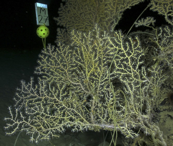
Fig. 2.

Multibeam map and imaging tracklines from survey of MC036 site. High-resolution map from an AUV Sentry multibeam survey of a portion of the MC036 hardground area identified from a 3D seismic survey. The red lines indicate the track lines flown by Sentry at an altitude of 5 m to collect digital images for identification of areas hosting corals. (Lower Right) Image of corals taken at this site by Sentry.
Assessment of Anthropogenic Impact to Corals
In November 2011, we used an ROV to assess potential impact from the spill to nine sites in addition to the site already determined to have been impacted in Mississippi Canyon (MC) 294 (all sites are referred to by the BOEM 3 × 3 nm lease block designation). These included five sites discovered using towed cameras and the AUV Sentry as described above and other sites discovered previously (Fig. 1 and Table 1). With the exception of the Vioska Knoll (VK) sites and Atwater (AT) 357 that each harbor thousands of coral colonies, all octocoral colonies encountered were photographed from a horizontal perspective from within 1–3 m of the colonies using a digital still camera. Images of octocoral colonies of sufficient resolution were then digitized as described in Hsing et al. (18) with all branches coded as colonized by hydroids, otherwise obviously impacted (covered with flocculent material, with bare skeleton, excessive mucous production, or sloughing tissue), or not obviously impacted (which included discolored branches and branches without expanded polyps). These characterizations were performed independently by two observers and the averages of their results are shown for all sites in Table S1.
Table 1.
Coral sites surveyed in November 2011 for impact from the DWH spill
| Site | Latitude | Longitude | Depth, m | Distance to the Macondo wellhead, km | No. of octocorals imaged with digital still camera | No. with damage to >5% of colony |
| AT357 | 27.5867 | −89.7048 | 1,050 | 183 | 52 | 1 |
| MC036 | 28.9354 | −88.2014 | 1,090 | 27 | 17 | 1 |
| MC118 | 28.8527 | −88.4920 | 880 | 18 | 16 | 2 |
| MC159 | 28.7872 | −88.6347 | 920 | 27 | 19 | 1 |
| MC294 | 28.6722 | −88.4765 | 1,370 | 13 | 54 | 39 |
| MC297 | 28.6825 | −88.3450 | 1,560 | 6 | 68 | 49 |
| MC344 | 28.6337 | −88.1698 | 1,850 | 22 | 30 | 7 |
| MC507 | 28.4857 | −88.8509 | 1,040 | 55 | 10 | 2 |
| VK906 | 29.0694 | −88.3774 | 390 | 37 | na | nd |
| VK826 | 29.1560 | −88.0165 | 500 | 58 | na | nd |
na, not applicable—corals at these sites were not individually imaged; nd, none detected in the video surveys.
A time series of coral images from MC294 starting in November 2010 allowed documentation of the changes in the appearance of corals confirmed to have been impacted from the spill in 2010 (9, 18). This temporal study allowed us to recognize corals at other sites that were impacted in the same time frame as those confirmed to have been impacted by the spill, even though the adherent flocculent material originally present on the impacted corals was normally no longer present. At this later point in time, octocorals originally impacted to over 20% of their colony were often patchily colonized by hydroids (18), a feature not seen on deep-water octocorals at sites distant from the Macondo wellhead. Because the impacted corals at MC294 had not lost appreciable numbers of branches by November 2011, we did not include coral “stumps” or dead octocoral colonies without small branches in our analyses of impact from the DWH spill to the other sites.
Most of the sites surveyed did not show visible evidence of acute recent impact to the colonial coral communities. Two coral sites to the north of the Macondo wellhead in lease blocks VK906 and VK826, in water depths ranging from 380 to 550 m, are 37 and 58 km from the Macondo wellhead, respectively. These shallower sites each harbor thousands of coral colonies, had been visited numerous times by our research group before the spill occurred, and continued to show no visible signs of recent impact to the scleractinian (Lophelia pertusa), octocoral (primarily Callogorgia americana, but also including Paramuricea type A and C), or antipatharian (primarily Leiopathes glaberrima) corals present at the sites. A previously discovered site 183 km to the southwest in lease block AT357 at 1,050 m water depth was imaged in detail for the first time, to our knowledge, in 2011. This site was found to harbor thousands of coral colonies and is the largest community of corals at a depth greater than 1,000 m currently known in the GoM. This site is dominated by the octocoral Paramuricea sp. B3 (19) and the scleractinian coral Madrepora cf. prolifera. There was no visual evidence indicating recent impact to this community observed during the ROV dives at this site (18) (Table S1). Another newly discovered site in MC036 has extensive areas of hardground and only a portion of it was explored by Sentry. Seventeen corals were discovered in one corner of the surveyed area (Fig. 2) but there was no consistent visual evidence of recent impact to these corals. Similarly, we found no evidence of widespread impact to the octocoral community at another site only 18 km to the north of Macondo at 880 m water depth (MC118) (although a single small colony with large areas of dead skeleton was observed).
Two of the newly discovered sites had limited rocky outcrops and few coral colonies. The site in lease block MC203 at 951 m water depth hosted 19 coral colonies and the other in lease block MC507 about 55 km southwest of Macondo at 1,040 m water depth harbored 10 coral colonies. There was fishing line among the corals at both of these sites, and one coral at the MC507 site which was tangled in long line had a patchy injury pattern similar to what was present at MC294 (but not as extensive; Fig. 3). Although there were other corals at this site with large areas of dead skeleton, the absence of small branches on the dead portions was not consistent with the very recent impact as seen at MC294 and more likely reflects historical impact from fishing line at this isolated site.
Fig. 3.
A colony of a paramuricid coral at MC506 tangled in fishing line.
There was extensive evidence of recent impact to the corals at the newly discovered site in MC297. This site is 6 km to the south-southeast of the Macondo wellhead at 1,560 m water depth, 13 km from the impacted site in MC294. A total of 68 octocoral colonies were photographed at this site in two areas separated by about 370 m. Sixty-three of the coral colonies imaged at this site shared the characteristic appearance of the adverse impact from the DWH spill present in corals at MC294 at the same point in time. Forty-nine coral colonies showed evidence of recent impact to over 5% of the colony and 38 of the corals displayed evidence of recent impact to over 10% of the colony (Table 1 and Table S1). Fig. 4 A and B shows one of the impacted corals from MC294 as it first appeared when discovered in November 2010, and its appearance in November 2011. In November 2010, a brown flocculent material covered much of the coral with live yellow coral tissue evident in the middle and lower left portion of Fig. 4A (from 2010). By November 2011 most of the flocculent material was gone and hydroids had colonized portions of the skeleton with no living material (Fig. 4B). The extensive patchy growth of hydroids on these paramuricid octocorals is very distinctive and was not present on any of the corals at other sites described above or at other sites visited previously. In Fig. 4 C and D are two of the corals from the site in MC297 photographed in November 2011 that exhibit this characteristic patchy covering of epizoic hydroids. Hsing et al. (18) reported that hydroid colonization only occurred on corals originally impacted on over 20% of their surface and only on portions that showed obvious signs of impact when first visited 3 mo after the well was capped. Thus, colonization by hydroids is an indication of impact to a significant portion of the colony.
Fig. 4.

Recently impacted corals from MC294 and MC297. (A) Colony of Paramuricea biscaya at MC294 as it appeared in November 2010, 3 mo after the well was capped. (B) The same coral in November 2011. (C and D) Colonies of P. biscaya at MC297 in November 2011. Note the extended polyps and apparently healthy yellow tissue on most branches, and the patchy brown hydroid growth on other portions of the colonies.
The level of impact to the coral population at MC297 is comparable to what was experienced by the coral community at MC294. Like MC294, most of the coral colonies still exhibited signs of impact in November 2011. The rate of very heavy (>50%) impact to coral colonies in November 2011 was approximately twice as high at MC297 (16%) compared with MC294 (8%). Two completely dead or hydroid-covered colonies still retained many small branches, an attribute consistent with recent impact. Similar to the community at MC294, the visible effects were patchy not only across the site, but also on individual coral colonies. This pattern suggests that the impacting agent was not evenly dispersed in the bottom water, but rather present as microdroplets or particles; whether this represents small droplets of oil/dispersant (20, 21) or oil-containing marine snow (8) is not known.
In a response to White et al. (9), Boehm and Carragher (22) suggested that the impact to the community of MC294 could have been due to causes such as slope failure that may have occurred coincidently in the same time frame as the DWH blowout, or other local causes. The discovery of this second community, at the same stage of postimpact injury progression 13 km away from MC294, indicates that the impact cannot be explained by a more localized event. That this is the only coral community discovered to date that is closer to the Macondo wellhead than the MC294 community and the fact that most other communities further away do not show similar visible signs of impact provide additional evidence linking the current state of both communities to the DWH blowout.
Although most other deep-water coral communities we have visited in the GoM did not show widespread visual evidence of recent acute impact, evidence of injury was found at one other site near the Macondo wellhead. This site in lease block MC344 at 1,850–1,950 m depth is 22 km east of the wellhead. At this site 30 corals were photographed. The visual evidence of impact to this community in November 2011 was much less severe than that observed at MC294 or MC297. Fourteen coral colonies exhibited evidence of recent impact noted by both observers. Most of these had only small areas impacted, either because the corals were quite small or because only small portions of the corals were impacted, although six corals showed visible evidence of impact to over 10% of the colony. Although largely minor, visible effects were widespread at this site. At this site there was also very little colonization of the impacted corals by hydroids, perhaps reflecting a lighter initial impact and a slower progression to this stage, or a difference in hydroid colonization abilities associated with the difference in location and depth. However, the patchy nature of the impact and the appearance of the impacted branches are consistent with what was observed at MC294 and MC297 (Fig. 5). We conclude that this site was also impacted at the same time and in the same way as the two sites closer to the Macondo wellhead, albeit not as heavily.
Fig. 5.

(A and B) Two Paramuricea sp. from MC344 in November 2011 with apparently healthy and visibly unhealthy and dead portions of the colonies apparent.
Although early National Oceanic and Atmospheric Administration models and empirical studies suggested that the deep-water plume of hydrocarbons from the blowout moved predominantly to the southwest, later models suggest a more dynamic pattern of swirling flow from the wellhead that could readily transport hydrocarbon rich fluids to the east in the direction of MC344 (23, 24). The data presented here and in White et al. (9) indicate that impact from oil and/or dispersant from the DWH spill occurred at depths greater than 1,000–1,300 m as predicted by most models.
Corals as Biomonitors of Anthropogenic Impact to the Deep Sea
Deep-sea corals are among the longest-lived animals on the planet, with some species living thousands of years (25, 26). Many octocorals, like the paramuricids that were the most abundant taxa at all of the sites below 1,000 m, normally maintain living polyps over their entire surface. These attached colonies obtain food from, and exchange respiratory gases with, the bottom water bathing their exposed surfaces. In essence, they are constantly sampling the water surrounding them. If impacted by waterborne agents, they cannot move nor cover their exposed tissues except by exuding a thin layer of mucous. If there is a significant impact to a portion of the colony, it may be recorded as damaged tissue, bare skeleton, or epizoic encrustation on that portion of the colony (9, 18, 27). If a colony dies, its skeleton remains attached to the sea floor for years, slowly losing smaller branches and providing a record of its existence and death. Because these colonial animals normally live for many hundreds of years, natural death is a rare event (19). As a result, these types of corals are reliable visual biomonitors of anthropogenic impact to the deep-sea benthos.
The time course and sequence of events that occur over the first 18 mo after deep-sea octocoral colonies are acutely impacted by a toxic waterborne agent has been well described (18). This documented timeline allowed for the recognition of acute impact to other sites, even after the initial appearance of the impact had changed, and the original causative agent(s) may have been removed with sloughing mucous and tissue, by currents, or by microbial activity. The distinctive appearance of the corals at some sites near the Macondo wellhead, and the absence of corals with these anomalous features at all other sites, leads to the conclusion that the acute impact to deep benthic megafauna communities was not limited to the one site discovered shortly after the event, but rather extended to at least two other deep coral habitats, and perhaps more in the region of the Macondo wellhead that have yet to be discovered.
We have now also carefully monitored corals at numerous other deep-water sites all over the northern GoM and found no compelling evidence of acute impact from the spill at any coral sites between 400 and 850 m depth or more than 30 km from Macondo. Although it is still possible that other sites will be discovered, the extensive survey and sampling reported here suggest that we have constrained the footprint of acute impact to deep-water coral communities in the GoM from the DWH blowout. However, it may still be many years before the effects of subacute impact are manifested in the deep-water coral communities of the wider GoM.
With our ever-increasing population and technological advancements, anthropogenic impact to deep-sea habitats and biota will likely continue to increase. Although far removed from surface and coastal waters, and from the consciousness of most people, deep-sea environments play numerous roles in the health of the world’s oceans. Many species of fishes and sharks use deep corals as spawning grounds or sites for deposition of eggs (28) (Fig. S2). Healthy deep-sea sediments are remarkably high in biodiversity, and important in global carbon and nitrogen cycling, decomposition processes, and energy flow to higher trophic-level consumers (29–31). Perhaps most importantly, we know relatively little about deep-sea fauna and communities, and therefore the full spectrum of ecosystem services derived from deep-sea biota and habitats is largely unknown. Accumulating baseline data on conditions in different deep-sea habitats as well as monitoring for changes in these habitats will prove to be critical when scientists are asked to evaluate the inevitable impacts these ecosystems will experience and provide input on mitigation.
Methods
Site Selection.
The acoustic amplitude maps used in this study were generated from 3D seismic data acquired by the oil industry and provided to BOEM as required by the permitting process. Although these data were shot and recorded primarily for exploration targets thousands of meters below the seafloor, they are also useful in characterizing changes in seafloor lithology. High positive anomalies are acoustically faster than both seawater and soft bottom mud, resulting in strong responses on the amplitude maps. High positives can be indicators of hydrocarbon migration pathways that have distorted the seismic response on vertical cross-sections. Typically, at historic or current hydrocarbon seep sites, high positive response is also associated with the presence of authigenic carbonates formed as a byproduct of bacterial activity in shallow subsurface sediments. These rocky, calcium carbonate substrates are suitable habitats for corals, but only where ocean bottom currents are adequate to keep unconsolidated hemipelagic mud off the top of the rock.
Sites for exploration were selected at the BOEM office in New Orleans using their 3D seismic database, which covers over 90% of the northern GoM continental slope. The data were analyzed for surface reflectivity or amplitude using Schlumberger’s Geoframe software on a Dell workstation. The Geoframe’s program ASAPwas used to further define the seafloor horizon, followed by the manual review for gaps in the seafloor identifications. Potential coral sites were identified by areas of high positive amplitude (reflectivity), appropriate bathymetry (near crests of canyons or steep slopes or on local highs), and subsurface profiles that identified faults and other fluid and gas migration pathways that could supply hydrocarbons for shallow microbial activity and production of authigenic carbonates.
Initial Site Survey.
Twenty-five sites selected from examination off the 3D seismic data were surveyed using a camera system deployed on a tether from a surface ship. One system, the TDI Brooks Drift Camera system, used a 14.7 mega-pixel Pentax digital camera with strobe illumination and the second, the WHOI TowCam SN 6004 used a 3.3 megapixel color camera with strobe illumination. Both were flown at a height of 2–5 m above the bottom of the sea floor. Over 44,500 images were collected with these systems and three sites with abundant carbonates and one with colonial corals were identified for further investigation. These four sites and five others were further surveyed by the AUV Sentry using a Reson7125 400 kHz multibeam echo sounder from an altitude of 25 m to obtain high-resolution bathymetry, with a postprocessed pixel size of 0.5 m. After automated processing at sea, small areas with small-scale bathymetric relief, such as would be caused by exposed boulders or slabs, were identified and surveyed again with the Sentry vehicle collecting overlapping digital images from 5 m above the sea floor in a series of small grid surveys centered on the features of interest (Fig. 2). During the 16 imaging deployments of the AUV Sentry, over 68,000 photographs were collected and colonial corals identified in 20 images. Sentry’s geodetic position was determined by ultrashort baseline acoustic navigation from the support vessel combined with the vehicle’s internal estimates of its relative motion provided by a combination of a Doppler velocity log and an inertial navigation system. The resulting vehicle geodetic position was determined to within 5 m, allowing targets to be directly acquired on subsequent ROV dives.
Quantification of Impact to Coral Colonies.
The sites surveyed by Sentry and towed cameras, plus previously known sites in the vicinity of the Macondo wellhead, were revisited with an ROV. The corals imaged by Sentry were located again and the surrounding areas searched using sonar to locate exposed carbonates that potentially host corals. At each site except AT357, VK826, and VK906, we attempted to image every coral encountered. At AT357, VK826, and VK906 we actively searched among the thousands of corals present at these sites for colonies that were covered with flocculent material, colonized by hydroids, or contained portions of dead skeleton. Corals were also opportunistically imaged during survey of these sites. The visible impact to each coral colony was quantified on high-resolution digital images acquired from an ROV within 1–3 m of the coral. Following the methods of Hsing et al. (18), all portions of coral branches not obscured by associated organisms were categorized into one of the following categories and digitized using Fiji 1.4 (32) or Inkscape 0.48.2 (33) software: (i) covered by hydroids: branches obviously covered by hydroids; (ii) other impacted branches, i.e., branches not covered with hydroids but either covered by floc, showing excess mucous, tissue damage, or bare skeleton; and (iii) no visible impact, i.e., branches not clearly in either of the other two categories. All corals were digitized by three independent observers instructed to use category iii by default unless visible impact as described above, or hydroid growth, was clear in the image. Because an ANOVA showed the differences between observers to be small, simple arithmetic means of their digitized values were used for downstream analyses (Table S1).
Supplementary Material
Acknowledgments
We thank A. Fundis and G. Kurras for oversight of the towed camera system; and A. Chopra, W. Cho, A. Govindarajan, S. Herrera, A. Lukasiewicz, T. Muric, C. Munro, and M. Zelenevich for assistance with data collection. We also thank I. MacDonald for providing the digital still camera used for the in situ imaging, the crews of the ships and deep submergence vehicles used for this study, and BP for access to AUV bathymetry and side-scan data. This work was supported by the Assessment and Restoration Division of the National Oceanic and Atmospheric Administration (NOAA) and Gulf of Mexico Research Initiative funding to support the Ecosystem Impacts of Oil and Gas Inputs to the Gulf (ECOGIG) consortium administered by the University of Mississippi. The research cruises and some analyses were funded by the NOAA and BP as part of the Deepwater Horizon oil spill Natural Resource Damage Assessment. This is Contribution 195 from the ECOGIG consortium.
Footnotes
Conflict of interest statement: The cruises and some of the analyses were funded by National Oceanic and Atmospheric Administration and BP as part of the Deepwater Horizon (DWH) oil spill Natural Resource Damage Assessment (NRDA). Neither the DWH NRDA Trustees nor BP had a role in sample processing, data analysis, decision to publish, or preparation of the manuscript. Preapproval to submit the manuscript for publication was provided by representatives of the NRDA Trustees and independently by the Bureau of Ocean Energy Management (BOEM). W.W.S. is an employee of BOEM.
This article is a PNAS Direct Submission. C.H.P. is a guest editor invited by the Editorial Board.
Data deposition: The coral image dataset has been deposited at Penn State ScholarSphere, https://scholarsphere.psu.edu/collections/pv63g1177 (Gulf of Mexico Research Initiative GRIDC#R1.x132.136:0020).
This article contains supporting information online at www.pnas.org/lookup/suppl/doi:10.1073/pnas.1403492111/-/DCSupplemental.
References
- 1.Socolofsky SA, Adams EE, Sherwood CR. Formation dynamics of subsurface hydrocarbon intrusions following the Deepwater Horizon blowout. Geophys Res Lett. 2011;38(9):L09602. [Google Scholar]
- 2.Peterson CH, et al. A tale of two spills: Novel science and policy implications of an emerging new oil spill model. Bioscience. 2012;62(5):461–469. [Google Scholar]
- 3.Camilli R, et al. Tracking hydrocarbon plume transport and biodegradation at Deepwater Horizon. Science. 2010;330(6001):201–204. doi: 10.1126/science.1195223. [DOI] [PubMed] [Google Scholar]
- 4.Joye SB, MacDonald IR, Leifer I, Asper V. Magnitude and oxidation potential of hydrocarbon gases released from the BP oil well blowout. Nat Geosci. 2011;4(7):160–164. [Google Scholar]
- 5.Reddy CM, et al. Composition and fate of gas and oil released to the water column during the Deepwater Horizon oil spill. Proc Natl Acad Sci USA. 2012;109(50):20229–20234. doi: 10.1073/pnas.1101242108. [DOI] [PMC free article] [PubMed] [Google Scholar]
- 6.Ryerson TB, et al. Chemical data quantify Deepwater Horizon hydrocarbon flow rate and environmental distribution. Proc Natl Acad Sci USA. 2012;109(50):20246–20253. doi: 10.1073/pnas.1110564109. [DOI] [PMC free article] [PubMed] [Google Scholar]
- 7.Hazen TC, et al. Deep-sea oil plume enriches indigenous oil-degrading bacteria. Science. 2010;330(6001):204–208. doi: 10.1126/science.1195979. [DOI] [PubMed] [Google Scholar]
- 8.Passow U, Ziervogel K, Asper V, Diercks A. Marine snow formation in the aftermath of the Deepwater Horizon oil spill in the Gulf of Mexico. Environ Res Lett. 2012;7(3):035301. [Google Scholar]
- 9.White HK, et al. Impact of the Deepwater Horizon oil spill on a deep-water coral community in the Gulf of Mexico. Proc Natl Acad Sci USA. 2012;109(50):20303–20308. doi: 10.1073/pnas.1118029109. [DOI] [PMC free article] [PubMed] [Google Scholar]
- 10.White HK, et al. Reply to Boehm and Carragher: Multiple lines of evidence link deep-water coral damage to Deepwater Horizon oil spill. Proc Natl Acad Sci USA. 2012;109(40):E2648. [Google Scholar]
- 11.Roberts JM, Wheeler A, Freiwald A, Cairns S. Cold-Water Corals: The Biology and Geology of Deep-Sea Coral Habitats. Cambridge Univ Press; 2009. Cambridge, UK) [Google Scholar]
- 12.Joye SB, et al. The anaerobic oxidation of methane and sulfate reduction in sediments from Gulf of Mexico cold seeps. Chem Geol. 2004;205(3):219–238. [Google Scholar]
- 13.Pancost RD, et al. Lipid biomarkers preserved in hydrate-associated authigenic carbonate rocks of the Gulf of Mexico. Palaeogeogr Palaeoclimatol Palaeoecol. 2005;227(1):48–66. [Google Scholar]
- 14.Fisher C, Roberts H, Cordes E, Bernard B. Cold seeps and associated communities of the Gulf of Mexico. Oceanography (Wash DC) 2007;20:118–129. [Google Scholar]
- 15.Roberts HH, Shedd W, Hunt J., Jr Dive site geology: DSV ALVIN (2006) and ROV JASON II (2007) dives to the middle-lower continental slope, northern Gulf of Mexico. Deep Sea Res Part II Top Stud Oceanogr. 2010;57(4):1837–1858. [Google Scholar]
- 16.Diercks A-R, et al. Characterization of subsurface polycyclic aromatic hydrocarbons at the Deepwater Horizon site. Geophys Res Lett. 2010;37(20):L20602. [Google Scholar]
- 17.Operational Science Advisory Team 2010. Sub-sea and sub-surface oil and dispersant detection: Sampling and monitoring. Unified Area Command. Available at www.restorethegulf.gov/sites/default/files/documents/pdf/OSAT_Report_FINAL_17DEC.pdf. Accessed July 17, 2014.
- 18.Hsing P-Y, et al. Evidence of lasting impact of the Deepwater Horizon oil spill on a deep Gulf of Mexico coral community. Elem Sci Anthr. 2013;1:0000012. doi: 10.1073/pnas.1118029109. [DOI] [PMC free article] [PubMed] [Google Scholar]
- 19.Doughty CL, Quattrini AM, Cordes EE. Insights into the population dynamics of the deep-sea coral genus Paramuricea in the Gulf of Mexico. Deep Sea Res Part II Top Stud Ocean. 2014;99:71–82. [Google Scholar]
- 20.Adcroft A, et al. Simulations of underwater plumes of dissolved oil in the Gulf of Mexico. Geophys Res Lett. 2010;37(18):L18605. [Google Scholar]
- 21.Paris CB, et al. Evolution of the Macondo well blowout: Simulating the effects of the circulation and synthetic dispersants on the subsea oil transport. Environ Sci Technol. 2012;46(24):13293–13302. doi: 10.1021/es303197h. [DOI] [PubMed] [Google Scholar]
- 22.Boehm PD, Carragher PD. Location of natural oil seep and chemical fingerprinting suggest alternative explanation for deep sea coral observations. Proc Natl Acad Sci USA. 2012;109(40):E2647, author reply E2648. doi: 10.1073/pnas.1209658109. [DOI] [PMC free article] [PubMed] [Google Scholar]
- 23.Valentine DL, et al. Dynamic autoinoculation and the microbial ecology of a deep water hydrocarbon irruption. Proc Natl Acad Sci USA. 2012;109(50):20286–20291. doi: 10.1073/pnas.1108820109. [DOI] [PMC free article] [PubMed] [Google Scholar]
- 24.Spier C, Stringfellow WT, Hazen TC, Conrad M. Distribution of hydrocarbons released during the 2010 MC252 oil spill in deep offshore waters. Environ Pollut. 2013;173:224–230. doi: 10.1016/j.envpol.2012.10.019. [DOI] [PubMed] [Google Scholar]
- 25.Roark EB, Guilderson TP, Dunbar RB, Fallon SJ, Mucciarone DA. Extreme longevity in proteinaceous deep-sea corals. Proc Natl Acad Sci USA. 2009;106(13):5204–5208. doi: 10.1073/pnas.0810875106. [DOI] [PMC free article] [PubMed] [Google Scholar]
- 26.Prouty NG, Roark EB, Buster NA, Ross SW. Growth rate and age distribution of deep-sea black corals in the Gulf of Mexico. Mar Ecol Prog Ser. 2011;423:101–115. [Google Scholar]
- 27.Cerrano C, et al. A catastrophic mass-mortality episode of gorgonians and other organisms in the Ligurian Sea (North-western Mediterranean), summer 1999. Ecol Lett. 2000;3(4):284–293. [Google Scholar]
- 28.Baillon S, Hamel J-F, Wareham VE, Mercier A. Deep cold-water corals as nurseries for fish larvae. Front Ecol Environ. 2012;10(7):351–356. [Google Scholar]
- 29.Danovaro R, et al. Exponential decline of deep-sea ecosystem functioning linked to benthic biodiversity loss. Curr Biol. 2008;18(1):1–8. doi: 10.1016/j.cub.2007.11.056. [DOI] [PubMed] [Google Scholar]
- 30.Tyler PA. Disposal in the deep sea: Analogue of nature or faux ami? Environ Conserv. 2003;30(1):26–39. [Google Scholar]
- 31.Armstrong CW, Foley NS, Tinch R, van den Hove S. Services from the deep: Steps towards valuation of deep sea goods and services. Ecosyst Serv. 2012;2:2–13. [Google Scholar]
- 32.Schindelin J, et al. Fiji: An open-source platform for biological-image analysis. Nat Methods. 2012;9(7):676–682. doi: 10.1038/nmeth.2019. [DOI] [PMC free article] [PubMed] [Google Scholar]
- 33.The Inkscape Team 2011. Inkscape 0.48.2. Avalailable at www.inkscape.org. Accessed July 16, 2014.
Associated Data
This section collects any data citations, data availability statements, or supplementary materials included in this article.