

Abstract
The joint Taiwan-United States FORMOSAT-3/COSMIC (Constellation Observing System for Meteorology, Ionosphere, and Climate) mission, hereafter called COSMIC, is the first satellite constellation dedicated to remotely sense Earth's atmosphere and ionosphere using a technique called Global Positioning System (GPS) radio occultation (RO). The occultations yield abundant information about neutral atmospheric temperature and moisture as well as space weather estimates of slant total electron content, electron density profiles, and an amplitude scintillation index, S4. With the success of COSMIC, the United States and Taiwan are moving forward with a follow-on RO mission named FORMOSAT-7/COSMIC-2 (COSMIC-2), which will ultimately place 12 satellites in orbit with two launches in 2016 and 2019. COSMIC-2 satellites will carry an advanced Global Navigation Satellite System (GNSS) RO receiver that will track both GPS and Russian Global Navigation Satellite System signals, with capability for eventually tracking other GNSS signals from the Chinese BeiDou and European Galileo system, as well as secondary space weather payloads to measure low-latitude plasma drifts and scintillation at multiple frequencies. COSMIC-2 will provide 4–6 times (10–15X in the low latitudes) the number of atmospheric and ionospheric observations that were tracked with COSMIC and will also improve the quality of the observations. In this article we focus on COSMIC/COSMIC-2 measurements of key ionospheric parameters.
Keywords: radio occultation, ionosphere, GNSS
Introduction
Radio occultation (RO) is a conceptually simple remote sensing method that employs radio transmitter/receiver pairs with a signal path that transits a planetary limb (for more discussion see Coster and Komjathy [2008]). With a Global Positioning System (GPS) receiver on board a low Earth orbiting satellite, the amplitude and phase of GPS radio signals can be measured very precisely as the GPS satellite is occulted by Earth's ionosphere and atmosphere. Figure 1 illustrates the geometry of a RO event. In the 1990s, the maturing GPS constellation supported advanced RO techniques for sounding Earth's atmosphere and ionosphere. Ware et al. [1996] described the first proof-of-concept RO experiment (GPS/Meteorology). Numerous successful missions subsequently used Global Navigation Satellite System (GNSS) signals for atmospheric and ionospheric sounding [Yue et al., 2011]. COSMIC (Constellation Observing System for Meteorology, Ionosphere, and Climate), launched into orbit by the United States Air Force (USAF) from Vandenberg on 15 April 2006, is the first dedicated satellite constellation employing RO with near real-time data delivery [Kumar, 2006; Anthes et al., 2008].
Figure 1.

A demonstration of GNSS RO observational geometry and the corresponding retrieved profiles in ionosphere and atmosphere.
Space Weather Parameters From GNSS RO Technique
All GNSS satellites transmit signals at two different L band frequencies to provide a means for making ionospheric corrections for navigation solutions. In the RO geometry (Figure 1) at ionospheric tangent altitudes, the total electron content (TEC) along the GNSS raypath can be calculated from phase measurements of these two frequencies. After various biases and calibration factors have been considered, the absolute ionospheric TEC can usually be determined to within 2–3 TEC units (TECU, 1 TECU = 1016el/m2) [Yue et al., 2011]. Space weather users are often interested in the altitudinal electron density profile (EDP), which is derived through an Abel inversion under the assumption of ionospheric density spherical symmetry around the ray tangent point [Yue et al., 2013]. Although this assumption is not always satisfied in the ionosphere, COSMIC RO measurements generally provide the peak ion density of the ionospheric F layer to within 15% accuracy, and the altitude of the peak to within 20 km. Alternately, the RO TEC observations may be ingested directly into assimilative models together with other ground- and space-based ionospheric measurements to achieve higher-accuracy specifications [Komjathy et al., 2010; Yue et al., 2012].
The RO GNSS L band signals are also sensitive to ionospheric density irregularities along the raypath. By analyzing the signal-to-noise ratio (SNR) of the received RO signal, parameters such as the S4 index, which characterizes scintillation due to F region irregularities, can be derived. SNR fluctuations also reveal the presence of sharp sporadic E layers. Yue et al. [2013] have summarized most aspects of the RO space weather data processing including algorithms, assumptions, and error characteristics.
In comparison with other ionospheric monitoring techniques, GNSS RO has the following advantages: (1) the limb sounding geometry is complementary to ground-based upward looking or space-based nadir-viewing instruments, (2) high accuracy and precision, (3) high vertical resolution, and (4) full global coverage. RO data from COSMIC have been widely used to monitor ionospheric variability (e.g., solar cycle, seasonal, longitude, and altitude), ionospheric weather (e.g., geomagnetic storm response, solar flare response, and lower atmospheric driving disturbances), and ionospheric irregularities (e.g., sporadic E layer and scintillation). In addition, the global coverage and high vertical resolution have made the COSMIC ionospheric observations an important data source for ionospheric data assimilation models [Scherliess et al., 2009; Komjathy et al., 2010], improving space weather nowcasting and forecasting, as well as enabling the construction of global four-dimensional (space and time) ionosphere electron density reanalysis [Yue et al., 2012]. Figure 2 provides an example of reanalyzed monthly global 3-D electron density and the corresponding peak density (NmF2) and vertical TEC map at 1900 UT during September 2006.
Figure 2.
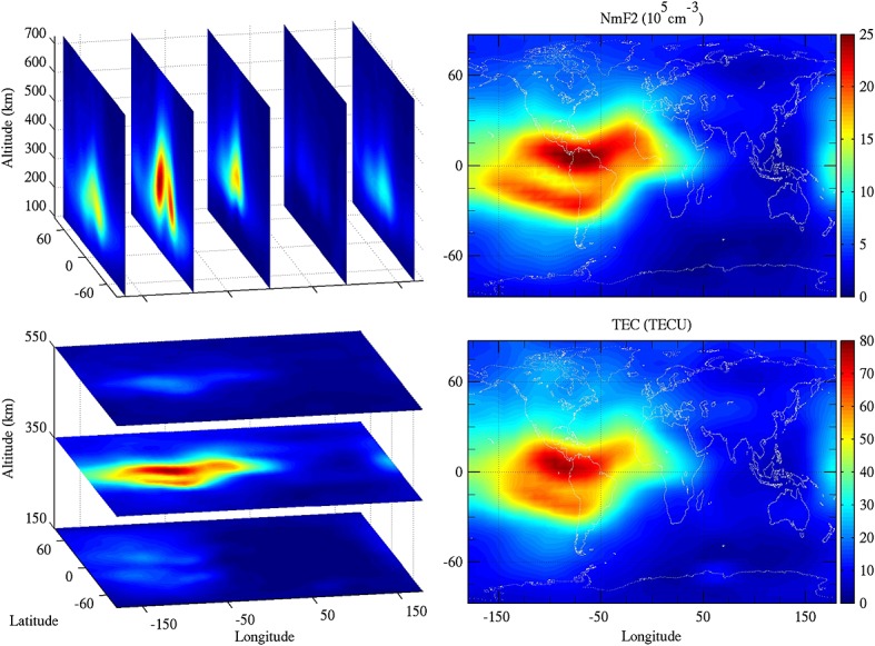
Example of the reanalyzed monthly global 3-D electron density and the corresponding peak density (NmF2) and vertical TEC map at 1900 UT in September 2006.
COSMIC and COSMIC-2
COSMIC consists of six identical microsatellites designed by Orbital Sciences Corporation, integrated, tested, and operated by Taiwan's National Space Organization (NSPO), with the science data products generated by the University Corporation for Atmospheric Research (UCAR). In addition to a RO receiver, each satellite carries two secondary space weather instruments: a Tiny Ionospheric Photometer (TIP) and Tri-Band-Beacon (TBB), which synergistically enhance the accuracy and utility of the COSMIC ionospheric observations. The high precision of the COSMIC RO measurements was verified by comparisons of closely collocated occultations that were available immediately after the launch of the satellites [Schreiner et al., 2007]. COSMIC has demonstrated the utility of RO for Numerical Weather Prediction applications, climate studies, and space weather monitoring via a constellation. In terms of space weather data products, as of October 2014, COSMIC has provided ∼4 M ionospheric EDPs, TEC arcs, and S4 index profiles, and more than 17800 h of quality controlled TIP nighttime radiances. Within its nominal mission lifetime of 2 years, COSMIC provided 2000–2500 occultations per day. Although the COSMIC satellites have suffered degradation since launch, they continue to produce 1000–1500 occultations per day.
The United States and Taiwan are moving forward with a follow-on RO mission (FORMOSAT-7/COSMIC-2) that will launch six satellites into low-inclination orbits in early 2016, and another six satellites into high-inclination orbits in early 2019. United States agencies, led by the National Oceanic and Atmospheric Administration (NOAA) are partnering with Taiwan's NSPO to execute the COSMIC-2 program [Cook et al., 2014]. The COSMIC-2 GNSS RO payload, named the TriG GNSS Radio-occultation System (TGRS), is being developed by the National Aeronautics and Space Administration (NASA) Jet Propulsion Laboratory (JPL) under USAF funding and will be capable of measuring more than 12,000 ionospheric profiles per day after all 12 satellites are fully deployed [Meehan et al., 2012]. The USAF is also providing two space weather payloads that will fly on each of the first six satellites: an Ultra High Frequency/L band/S band RF Beacon transmitter and the Ion Velocity Meter (IVM) instrument to measure in situ ion density and three-dimensional plasma drifts [Straus and Betz, 2014]. The COSMIC-2 mission will provide a revolutionary increase in the number of atmospheric and ionospheric observations that will greatly benefit the research and operational communities [Fong et al., 2012]. The IVM plasma drift observations, from which Electric Fields can be derived, will be of particular importance to the ionospheric research community since a significant amount of ionospheric weather is directly tied to electric field variability. The first six COSMIC-2 satellites will provide unprecedented spatial/temporal electric field specification at low latitudes. COSMIC-2 data will be processed and distributed to the research and operational communities free of charge by UCAR COSMIC Data Analysis and Archive Center (CDAAC).
Figure 3 shows the layout from both the top view and bottom view of the COSMIC-2 satellites, which are being designed and built by Surrey Satellite Technology Ltd. (SSTL) under a contract from NSPO [da Silva Curiel et al., 2013]. TGRS employs four antennas—two RO antennas and two POD (Precise Orbit Determination) antennas, with one of each type facing the ram and antiram directions. The larger RO antenna is used exclusively for tropospheric measurements and provides signals supporting onboard digital beam steering to increase measurement quantity in the lower atmosphere. Ionospheric measurements are made by the two POD antennas, which are canted slightly upward relative to the velocity direction. The IVM sensor is mounted on the spacecraft ram surface and the RF Beacon antenna is on the nadir deck. The COSMIC-2 space weather products and accuracy requirements are summarized in Table 1. As indicated, COSMIC-2 will observe a variety of ionospheric parameters, covering both small-scale and large-scale ionospheric phenomena. In comparison with COSMIC, the COSMIC-2 mission will provide a higher quantity and quality of space weather data. Figure 4 shows the comparison between the two missions in terms of constellation configuration, RO data coverage, and key parameters. Lee et al. [2013] and Yue et al. [2014] have performed observing system simulation experiments based on the COSMIC-2 constellations' orbit, and the results show that the COSMIC-2 ionospheric RO measurements will significantly enhance the capability of ionospheric middle- and large-scale nowcasts and forecasts.
Figure 3.
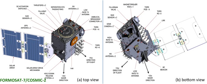
Layout of FORMOSAT-7/COSMIC-2 satellite viewed from both the (a) top and (b) bottom (image credit: SSTL).
Table 1.
Space Weather Products and Accuracy Requirement for COSMIC-2
| Instrument | Parameter | Observation Range | Accuracy |
|---|---|---|---|
| TGRS | Relative TEC | 0–2000 TECU | 0.3 TECU |
| Absolute TEC | 0–2000 TECU | 3 TECU | |
| Electron density profile | 3 × 10¹⁰–1013 el ⋅ m−3 | Less than the greater of 1011 el ⋅ m−3 and 20% | |
| Amplitude scintillation (S4) | 0.1 to 1.5 | 0.1 | |
| Phase scintillation (σϕ) | 0.1 to 20 rad | 0.1 rad | |
| IVM | Ion density | 109–5 × 10¹² m−3 | 5% |
| Ion composition | 0–1 | 5% | |
| Ion velocity | Cross track: ±1000 m/s; In track: ±1000 m/s | Cross track: ±5 m/s; In track: ±10 m/s | |
| RF Beacon | Amplitude scintillation (S4) | 0.1 to 1.5 | 0.1 |
| Phase scintillation (σϕ) | 0.1 to 20 rad | 0.1 rad |
Figure 4.
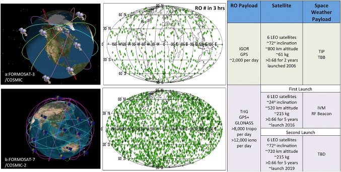
Comparison between (a) FORMOSAT-3/COSMIC and (b) FORMOSAT-7/COSMIC-2 in (left) constellation, (middle) RO events during 3 h, and (right) key parameters.
Acknowledgments
This material is based upon work supported by the National Science Foundation under the Cooperative Agreement AGS-1033112. The authors would like to acknowledge the National Science Foundation, Taiwan's NSPO, NOAA, NASA, and USAF for their support on FORMOSAT-3/COSMIC and continuing support on FORMOSAT-7/COSMIC-2. Portions of this research were carried out at JPL, California Institute of Technology, under a contract with NASA. Data from COSMIC, and many other missions, are processed, archived, and made freely available to the community by UCAR CDAAC (http://cdaac-www.cosmic.ucar.edu/cdaac/).
References
- Anthes RA, et al. The COSMIC/FORMOSAT-3 Mission–Early results. Bull. Am. Meteorol. Soc. 2008;89:313–333. [Google Scholar]
- Cook K, Wilczynski P. Wenkel M. 2014. The future of GNSS-RO for global weather monitoring and prediction—A COSMIC-2/FORMOSAT-7 Program status update, presented at the 8th FORMOSAT-3/COSMIC data users' workshop, Boulder, Colo.
- Coster A. Komjathy A. Space weather and the Global Positioning System. Space Weather. 2008;6 S06D04, doi: 10.1029/2008SW000400. [Google Scholar]
- da Silva Curiel A, Lambert M, Liddle D, Sweeting M, Chu V, Fong C-J. Chang G-S. 2013. Introduction to FORMOSAT-7/COSMIC-2 mission, proceedings of the 27thAIAA/USU Conference on Small Satellites, Logan, Utah.
- Fong C-J, Chu V, Yen NL, Ling J, Liu J-Y. Chang G-S. 2012. FormoSat-7/COSMIC-2 Radio Occultation Mission: From research to operations, presented at the International Radio Occultation Working Group (IROWG) 2nd Workshop, Estes Park, Colo.
- Komjathy A, Wilson B, Pi X, Akopian V, Dumett M, Iijima B, Verkhoglyadova O. Mannucci AJ. JPL/USC GAIM: On the impact of using COSMIC and ground-based GPS measurements to estimate ionospheric parameters. J. Geophys. Res. 2010;115 A02307, doi: 10.1029/2009JA014420. [Google Scholar]
- Kumar M. New satellite constellation uses radio occultation to monitor space weather. Space Weather. 2006;4 S05003, doi: 10.1029/2006SW000247. [Google Scholar]
- Lee IT, Tsai HF, Liu JY, Lin CH, Matsuo T. Chang LC. Modeling impact of FORMOSAT-7/COSMIC-2 mission on ionospheric space weather monitoring. J. Geophys. Res. Space Physics. 2013;118:6518–6523. doi: 10.1002/jgra.50538. [Google Scholar]
- Meehan T, Esterhuizen S, Franklin G, Tien J, Young L, Bachman B, Munson T, Robison D. Stecheson T. 2012. Development status of NASA's TriG GNSS science instrument, presented at the International Radio Occultation Working Group (IROWG) 2nd Workshop, Estes Park, Colo.
- Scherliess L, Thompson DC. Schunk RW. Ionospheric dynamics and drivers obtained from a physics-based data assimilation model. Radio Sci. 2009;44 RS0A32, doi: 10.1029/2008RS004068. [Google Scholar]
- Schreiner W, Rocken C, Sokolovskiy S, Syndergaard S. Hunt D. Estimates of the precision of GPS radio occultations from the COSMIC/FORMOSAT-3 mission. Geophys. Res. Lett. 2007;34 L04808, doi: 10.1029/2006GL027557. [Google Scholar]
- Straus P. Betz A. 2014. COSMIC-2: A platform for advanced ionospheric observations, presented at the 2014 NOAA Space Weather Workshop, Boulder, Colo.
- Ware R, et al. GPS sounding of the atmosphere from low Earth orbit: Preliminary results. Bull. Am. Meteorol. Soc. 1996;77:19–40. [Google Scholar]
- Yue X, Schreiner WS, Hunt DC, Rocken C. Kuo Y-H. Quantitative evaluation of the low Earth orbit satellite based slant total electron content determination. Space Weather. 2011;9 S09001, doi: 10.1029/2011SW000687. [Google Scholar]
- Yue X, et al. Global 3-D ionospheric electron density reanalysis based on multisource data assimilation. J. Geophys. Res. 2012;117 A09325, doi: 10.1029/2012JA017968. [Google Scholar]
- Yue X, Schreiner WS, Kuo Y-H, Hunt DC. Rocken C. 2013. GNSS radio occultation technique and space weather monitoring, proceedings of the 26th International Technical Meeting of the ION Satellite Division, ION GNSS + 2013, Nashville, Tennessee.
- Yue X, Schreiner WS, Kuo Y-H, Braun JJ, Lin Y-C. Wan W. Observing system simulation experiment study on imaging the ionosphere by assimilating ground GNSS, LEO based radio occultation and ocean reflection, and cross link. IEEE Trans. Geosci. Remote Sens. 2014;52(7):3759–3771. doi: 10.1109/TGRS.2013.2275753. [Google Scholar]