Significance
Monumental construction was one way that past societies reconfigured their landscapes in response to social and environmental factors. Given that these factors changed through space and time, societies often constructed multiple types of monuments. We develop a maximum entropy modeling (MaxEnt) framework for identifying the spatioenvironmental factors that mattered most in the placement of different monument types. We turned to MaxEnt, given its ability to model spatial distributions from presence-only data. With modern development continuing to destroy archaeological sites across the globe, archaeological datasets, including monument locations, are evermore restricted to being presence-only data. Our framework shows how archaeologists can harness MaxEnt to develop robust models of past cultural processes, including monumentality, even when faced with limited, presence-only data.
Keywords: archaeology, monuments, landscape, maximum entropy modeling, Great Lakes
Abstract
Building monuments was one way that past societies reconfigured their landscapes in response to shifting social and ecological factors. Understanding the connections between those factors and monument construction is critical, especially when multiple types of monuments were constructed across the same landscape. Geospatial technologies enable past cultural activities and environmental variables to be examined together at large scales. Many geospatial modeling approaches, however, are not designed for presence-only (occurrence) data, which can be limiting given that many archaeological site records are presence only. We use maximum entropy modeling (MaxEnt), which works with presence-only data, to predict the distribution of monuments across large landscapes, and we analyze MaxEnt output to quantify the contributions of spatioenvironmental variables to predicted distributions. We apply our approach to co-occurring Late Precontact (ca. A.D. 1000–1600) monuments in Michigan: (i) mounds and (ii) earthwork enclosures. Many of these features have been destroyed by modern development, and therefore, we conducted archival research to develop our monument occurrence database. We modeled each monument type separately using the same input variables. Analyzing variable contribution to MaxEnt output, we show that mound and enclosure landscape suitability was driven by contrasting variables. Proximity to inland lakes was key to mound placement, and proximity to rivers was key to sacred enclosures. This juxtaposition suggests that mounds met local needs for resource procurement success, whereas enclosures filled broader regional needs for intergroup exchange and shared ritual. Our study shows how MaxEnt can be used to develop sophisticated models of past cultural processes, including monument building, with imperfect, limited, presence-only data.
Monuments, such as pyramids, earthworks, and mounds, have long attracted archaeological attention. Monuments, being larger and more striking than other archaeological remains, were first treated as distinct developments. Over time, archaeological research has shown that monuments were commonplace. Building monuments was one way past societies spatially and materially reconfigured their cultural landscapes in response to the variable social and ecological factors that they encountered. Understanding the impact of spatial and material landscape reconfigurations, including monuments, on societal development remains a grand challenge for archaeology (1).
Given socioecological factors varied both spatially and temporally, regions where monuments formed part of the response to these factors frequently came to host different, multiple, and overlapping arrays of monuments (2–5). When faced with multimonumental landscapes, it is critical for archaeologists to be able to identify the interplay of socioecological factors in the distribution of each monument type. This identification, however, can be daunting, especially because it requires disentangling patterns over very large areas. Here, we develop an approach using the geospatial technique maximum entropy modeling (MaxEnt) to understand the differential contributions of spatioenvironmental factors to monument building across large landscapes. We show our approach with an example of monument distributions in Michigan.
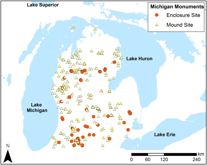
During Late Precontact (ca. A.D. 1000–1600), relatively low-density mixed forager–fisher–horticultural communities built two different types of monuments in Michigan: mounds and earthwork enclosures (Fig. 1). We have proposed elsewhere that these co-occurring ceremonial monuments had different roles during Late Precontact times: mounds, marking key local resource zones, served as local connection hubs and enclosures served as places of intergroup aggregation, exchange, and shared ritual (5). These ideas were developed from archaeological research on a subset of extant mound and enclosures located in north central Michigan. Recognizing that an estimated 80% of these features have been lost to post–Euro-American settlement/development, we conducted archival research to create a more representative database of these sites across Michigan inclusive of extant and destroyed monument locations.
Fig. 1.
Mounds and circular earthwork enclosures in Michigan (entire geospatial database created through archival research with early state archaeological records).
We used this georeferenced database of occurrence records and 13 spatioenvironmental variables in MaxEnt modeling to ask if mounds and enclosures were placed in contrasting positions in the landscape and if contrast provides insight into their roles during Late Precontact. We conducted analyses on the MaxEnt output to quantify the contribution of each spatioenvironmental variable to the distribution of mounds and enclosures. Doing this analysis, we identified key differences between the spatioenvironmental variables that mattered most to mound and enclosure landscape placement. These differences extend the view that precontact indigenous peoples in Michigan used these two types of monuments to answer different but simultaneously pressing social, economic, and ideological demands: mounds for local ones and enclosures for regional ones.
MaxEnt Framework for the Study of Monumentality
Geospatial technologies have made connecting cultural activities and environmental variables at large scales more feasible. Archaeologists have increasingly looked toward advanced geospatial modeling to investigate past landscapes (6, 7). Many available geospatial modeling approaches, however, are not designed for presence-only (occurrence) data and therefore, present problems for archaeologists. Archaeologists often know where some but not all sites were, and they rarely know for certain where past sites are absent. Given that many archaeological site records are occurrence data, including monument locations, archaeologists need modeling approaches that can tie environmental and geospatially derived data layers together with presence-only data. MaxEnt is one such approach.
The principle of maximum entropy originates in statistical mechanics (8), but its application has been expanded to many disciplines. MaxEnt has been especially developed as a species distribution modeling approach in ecology used for predicting habitat suitability of plant and animal species from presence-only records (9–13). MaxEnt allows for any number of continuous or discrete spatioenvironmental factors to be used as predictor variables for the species of interest (11–13). Predictor variable values are extracted from occurrence locations and randomly located background points across the sampling area to develop a statistical model that extrapolates a species habitat probability map across the landscape (13). Paleodistribution modeling, where floral and faunal species distributions are hindcast, has also been explored during the past decade (14, 15).
Such paleodistribution modeling has recently been appreciated as a potentially powerful tool for understanding human prehistory (14). MaxEnt emerges as a particularly useful approach for archaeological applications, because it commonly outperforms other modeling techniques that use presence-only data, especially when dealing with small sample sizes or nonrandom sampling (16). Accordingly, MaxEnt has increasingly been used in creating predictive models of the distribution of past human activities (16–20). In this research, MaxEnt has been used to identify shared spatioenvironmental parameters among the locations of known archaeological sites/features and extrapolate other geographic locales where these parameters are present. Archaeologists have used these outputs to examine and compare the total ranges of culture groups adaptations, identify ecocultural niches (17, 18), and build predictive models of archaeological features (16, 19, 20).
These recent uses of MaxEnt modeling have proven to be robust and informative. We explore how MaxEnt distribution modeling can be harnessed in additional ways for archaeological questions about past cultural processes, including monument construction and placement. Extending the ecological metaphor from MaxEnt’s use in species distribution modeling, monument construction can be seen as a cultural response to the specific mix of environmental, spatial, and social variables in a given landscape. Archaeologists can input archaeological monument occurrence data and any number of relevant spatioenvironmental variables into MaxEnt to create a probability map of monument location (in essence, a “monument habitat” map). The cultural process of monument building then becomes the “species” whose distribution is predicted. This framework shares some logic with the recent work by Saatchi et al. (21) to estimate aboveground biomass, wherein biomass classes were broken into presence data, and each biomass species was modeled across the landscape. After a monument habitat distribution is established, the relative contribution of each included spatioenvironmental predictor variable in determining overall distribution can be statistically analyzed to determine which variables mattered most in monument landscape placement.
We suggest that using MaxEnt modeling in this way is powerful for examining the frequently occurring cases where regions host multiple types of monuments. Each type of monument in the landscape can be separated into its own occurrence dataset and run through the model using the same set of spatioenvironmental variables. The contributions of the input variables for each type of monument can be quantified. Similarities and differences in the contributing factors to the geographic distribution of each type of monument can then examined; this offers a robust means of understanding how monuments were built in response to varied socioecological demands.
Mounds and Earthwork Enclosures of Michigan
Mounds and earthworks are ubiquitous features across the eastern United States, and they have long been the focus of popular speculation, archaeological investigation, and post–Euro-American destruction (22, 23). These earthen constructions represent some of the most interesting examples of monument building anywhere in the world (2, 5, 24–27). Although overshadowed by striking sites in neighboring parts of the eastern United States, like Cahokia in Illinois and the Newark Earthworks in Ohio, earthen constructions are still a major part of Michigan’s archaeological record.
Michigan displays two different kinds of earthen constructions: burial mounds and earthwork enclosures (Fig. 1). Notable burial mound complexes were built in southwestern Michigan as part of Middle Woodland Hopewellian traditions (28). Less elaborate, normal use conical burial mounds became geographically widespread features across Michigan’s Lower Peninsula during the Late Woodland Period and remained so through Late Prehistory (after ca. A.D. 800–1000 to A.D. 1600) (29) (Fig. 1).
Earthwork enclosures, large-scale geometric earthen features, were less common than mounds, reaching their highest density in southern Michigan and continuing into northern Indiana and Ontario (30–37) (Fig. 1). These constructions almost always date to Late Prehistory (ca. A.D. 1200–1600). Michigan’s enclosures share a common form of being circular ditch and embankment enclosures with planned entryways. Depending on geographic and temporal factors, they range from 30 to 120 m in diameter (38).
The later Late Woodland/Late Prehistoric Period (referred to here as Late Precontact; ca. A.D. 1000–1600) saw the co-occurrence of these two types of earthen constructions. A variety of perspectives has been developed about these constructions, and debate continues, particularly about the nature of enclosures (30, 35, 38, 39). A striking aspect of the research on mounds and enclosures is that, despite being shared features across Michigan’s forager–fisher–horticulturalists during Late Precontact, they are not typically investigated in conjunction with each other. However, it is the presence of both together that suggests that monument building was a particularly important part of life in Late Precontact Michigan.
Monuments are not superfluous to socioeconomic developments; they are intertwined with every aspect of community organization. These mounds and enclosures represent then a reconfiguration of the Late Precontact landscape tied to social, economic, and ideological developments (5). Here, we ask whether mounds and enclosures were placed in contrasting positions in the landscape in response to different spatioenvironmental variables and what insights these contrasts provide about their roles during Late Precontact.
Results and Discussion
The geospatial database of mounds and enclosures that we created (by working with archival archaeological files in Michigan) has 321 records: 60 enclosure locations and 261 mound locations (multiple enclosures and mounds are often found in one locale) (Fig. 1). Today, only 13 of these enclosure locales and 45 of these mound locales have a high certainty of still existing (that is, a destruction rate—since their recording in the late 1800s and early 1900s—of 78.33% for enclosures and 82.76% for mounds). These staggering rates of destruction show that it is imperative to use archives of early archaeological site records.
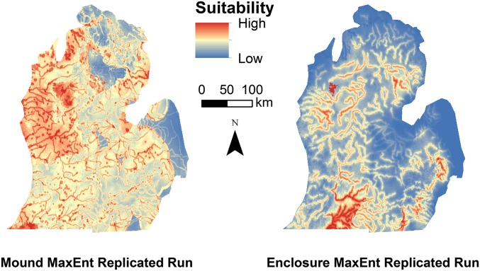
We conducted MaxEnt with 13 spatioenvironmental input variables (covariates) relevant to earthen construction location suitability and presence-only occurrence records of Late Precontact mounds/enclosures created through archival research. Covariates included temperature and precipitation regimes, elevation, and distance to key hydrographic features, representing a range of factors that impacted the subsistence practices, social developments, and settlement patterns of the region’s mixed fisher–forager–horticulturalists. Using modern temperature and precipitation covariates carries limitations for archaeological modeling. In recognition of these limitations, we did not rely on these as actual values for Late Precontact but used them to understand how areas across the landscape would have varied in temperature and precipitation relative to each other (i.e., warmer, wetter areas today would have been warmer, wetter areas during Late Precontact, even if absolute temperature and precipitation values have changed). The output produced a mound “habitat” suitability map and an enclosure habitat suitability map for all of Michigan (Fig. 2).
Fig. 2.
Replicated MaxEnt model output maps showing predicated mound habitat and enclosure habitat across Michigan.
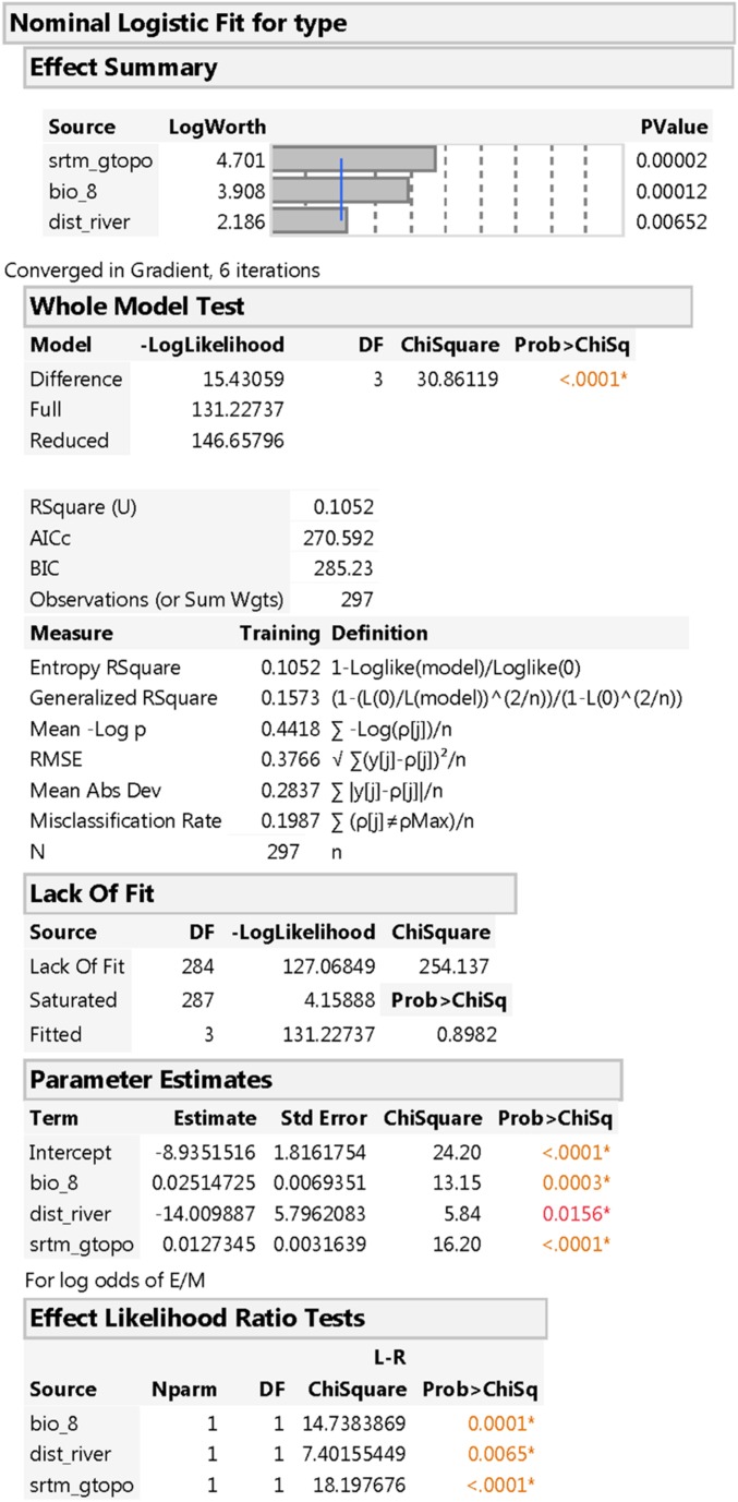
Visual inspection of these maps highlights that mound and enclosure features occupied, to extend the ecological metaphor, distinct “niches” in the landscape (Fig. 2). To quantify and compare the relative importance of input spatioenvironmental variables to the suitability of places for mounds and enclosures across the study area, we: (i) computed a table of variable overall contribution to MaxEnt model fit, (ii) ran jackknife tests for the training and testing datasets, and (iii) created individual variable response curves (40) (SI Text has expanded explanations and results of these analyses). Note that we also conducted an independent analysis of the discriminating power of input variables with nominal logistic regression and computed a multivariate correlation table for all input variables (presented in SI Text).
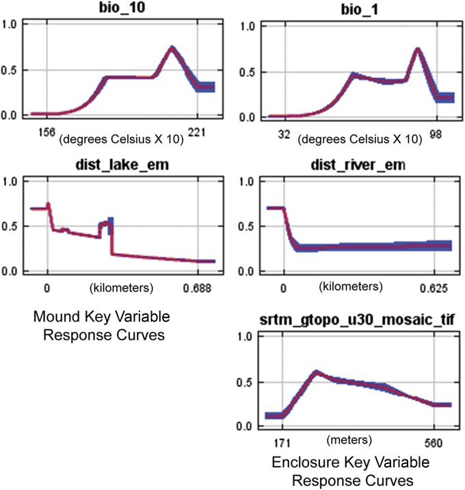
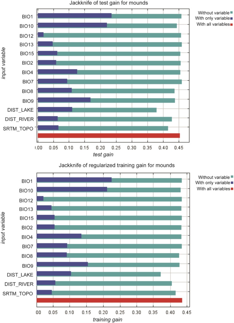
For mounds, two variables dominated the overall contribution to MaxEnt model fit: mean temperature of the warmest quarter (BIO10) and distance to an inland lake (61.9% together) (Table 1). In test and training jackknife tests, annual mean temperature (BIO1) very closely followed by mean temperature of the warmest quarter (BIO10) show the highest gains in isolation (SI Text). These two variables have the most useful information when used by themselves for predicting mound distribution (note that they are strongly positively correlated) (SI Text). The variable that decreases the gain the most when it is omitted from the model is distance to an inland lake; this variable contains the most information about mound distribution not present in the other variables (test results in SI Text). The response curve of distance to an inland lake shows that it is mound proximity to an inland lake that is the key to predicted suitability (Fig. 3).
Table 1.
The relative contribution of each included spatioenvironmental predictor variable in determining the overall fit of the MaxEnt model for mounds and enclosures (normalized to percentages)
| Variable | Mound contribution (%) | Enclosure contribution (%) |
| Mean temperature of warmest quarter (BIO10) | 41.9* | 0.1 |
| Distance to an inland lake | 19.6* | 3.8 |
| Mean temperature of driest quarter (BIO9) | 11.6 | 7.9 |
| Distance to a river | 10.9 | 22.9* |
| SRTM topography | 3.7 | 13.5 |
| Mean temperature of wettest quarter (BIO8) | 3.6 | 4.1 |
| Annual mean temperature (BIO1) | 3.2 | 25.6* |
| Precipitation of wettest month (BIO13) | 3 | 8.4 |
| Temperature seasonality (BIO4) | 1.1 | 1.3 |
| Mean diurnal range (BIO2) | 0.6 | 4.6 |
| Temperature annual range (BIO7) | 0.4 | 0 |
| Annual precipitation (BIO12) | 0.4 | 3.9 |
| Precipitation seasonality (BIO15) | 0.2 | 3.9 |
Top two contributors.
Fig. 3.
Response curves of key variables for mounds and enclosures (all variable curves are in SI Text). These curves were created using each input variable alone for the MaxEnt model for mounds and enclosures, which shows the dependence of predicted suitability as it patterns with the selected variable. The curves show the mean responses of the replicate MaxEnt runs (red) and ±1 SD (blue).
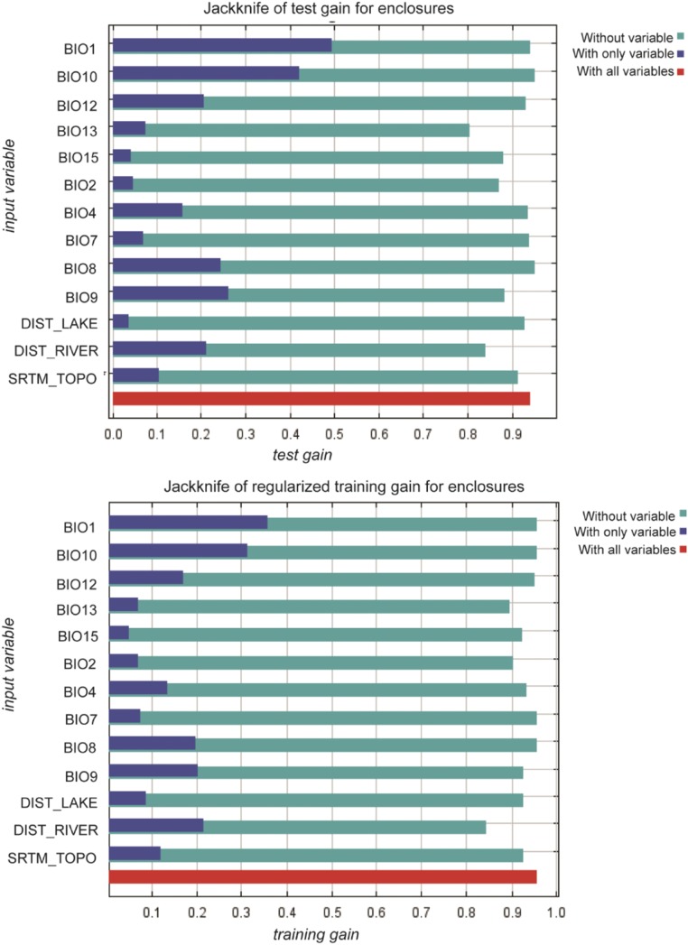
For enclosures, annual mean temperature (BIO1) and distance to a river made the largest contributions to MaxEnt model fit (48.5% together), with topography (Shuttle Radar Topography Mission, SRTM) a notable third as the only other double-digit contributor (Table 1). In both test and training jackknife tests, the environmental variable with the highest gain when used in isolation is annual mean temperature (BIO1). The variable that decreases the gain the most when it is omitted is distance to a river (test results in SI Text) The response curve of distance to a river shows clearly that it is enclosure proximity to a river that is the key to predicted suitability (Fig. 3).
The juxtaposition of the importance of inland lakes to mounds and rivers to enclosures is striking. Michigan’s 11,037 inland lakes are localized hydrographic features positioned in single ecosystems covering small to moderate areas and having relatively circumscribed watersheds. Rivers, in contrast, are regional hydrographic features, traversing substantial distances, crossing ecosystems, and having large watersheds. These features seem then positioned to have distinct geographic reaches—local and regional, respectively. These results can be understood within the context of Late Precontact.
Although there is no consensus interpretation for Late Precontact, it is generally agreed that, after ca. A.D. 1000, the region saw an intensification of a mixed economy involving the variable adoption of maize horticulture, targeted fishing of seasonal spawns, and intensified use of wild plant foodstuffs (particularly those amenable to storage), such as acorns, berries, maple syrup, and wild rice (41–43). Spatial proximity became increasingly important with these economic shifts, and across Michigan, communities found themselves engaging in their annual mobility rounds within more restricted territories. With the (wild and cultivated) resource base of the region being both seasonally variable and unpredictable year to year, the reduction in the spatial range that communities could exploit to harvest food heightened the risk of experiencing resource failure and scarcity.
We have argued that, within this context, dual needs arose to (i) maximize and extend the use life of local resources and (ii) increase interaction with other communities occupying different territories and resource bases (5, 39, 43, 44). As introduced above, we have suggested that the construction of mounds filled local needs and that the construction of enclosures filled more regional ones. The results from MaxEnt, derived independently and from a larger dataset than used in this previous work, extend this view.
Mounds and Inland Lakes.
Inland lakes, being naturally full of food (fish and wild rice), formed important hubs for maximizing local resource procurement (5, 42, 43). Cross-cultural ethnographic and archaeological studies have widely documented how small-scale societies, like those in Late Precontact Michigan, legitimize claims to resources with their ancestors, which is frequently ritualized through the construction of specialized, bounded areas for disposal of the dead, such as burial mounds (45), which helps frame why proximity to inland lakes emerged in our MaxEnt modeling as important in burial mound positioning. Mounds were physical representations of the enduring relationship between the ancestors and the living (46). The placement of the dead helped the living stake out claims to inland lakes, key multiresource-producing locales.
We have argued previously that one of the multiresource offerings of inland lakes was that some had a climatic ameliorating effect that created microclimates with extended growing seasons sufficient for small-scale maize horticulture on their shorelines (44). Although the full extent of maize cultivation is still debated, maize cultivation was practiced at variable rates during Late Precontact. We find it striking that the second largest contributor to the fit of the MaxEnt model of mound suitability is one seemingly related to growing season—mean temperature of the warmest quarter (BIO10) (Table 1). Areas with higher mean temperatures during the warmest quarter of the annual cycle predict mound landscape suitability (Fig. 3). In BIO10 across the study area today, this segment is July, August, and September, aligning with the growing season for successful prehistoric maize cultivation (47). Although compelling, correlations between BIO10 and BIO1 as well as limitations in deriving absolute measures from modern temperature and precipitation variables mean that additional work will be necessary to fully confirm this finding.
Enclosures and Rivers.
Despite being the largest features in Michigan’s archaeological landscape, enclosures have been subject to surprisingly little systematic investigation. They were first assumed to be fortifications, but work across northern and southern located enclosures has shown this to be an insufficient explanation. Today, instead, many agree that enclosures were special use, sacred spaces, but whether these were local or regional in nature is debated (30, 34–39).
Across our MaxEnt variable contribution analyses, we found that proximity to regional hydrographic features—rivers—mattered in enclosure distribution (Figs. 2 and 3 and Table 1). Canoe travel along Michigan’s major rivers enabled people to transport themselves and goods long distances (48). Enclosures were placed where there was access to regional transportation corridors. Looking at enclosures and mounds simultaneously helps highlight the fact that enclosure placement was meant to extend beyond the local. Looking at each monument type alone, we would miss their juxtaposition in the landscape. The fact that enclosures’ prime habitat proximate to rivers indicates a regional orientation becomes a more compelling conclusion when we see that the prime habitat for mounds is very different, oriented around local hydrographic features (inland lakes).
What was the purpose of such enclosure positioning? As we discussed above, Late Precontact communities across Michigan faced heightened risks of resource scarcity. Rivers, then, formed important avenues through which communities could increase their interaction with groups occupying different territories and resource bases. Such nonlocally circumscribed interaction would create opportunities for the trade of physical foodstuffs, providing immediate scarcity relief, while also securing future relief through the furthering of social relationships. In small-scale societies, like those of Late Precontact, the pooling of risk through sharing and storing social obligations, often through the creation and/or extension of kin relationships among dispersed communities, is a well-documented risk-buffering strategy (49). By placing enclosures (sacred monumental constructions), near rivers, communities provided designated, attractive, and accessible spaces for interaction, trade, and relationship building.
We have argued for the regional ceremonial importance of enclosures previously (5, 39). Some recent research emphasizes the importance of enclosures as locally embedded features, noting that, although they may share a circular form, they each have their own distinct layout and material signatures, reducing prospects that they had broader regional orientations (30, 35). In both our previous research and these recent arguments, the regional and/or local import of enclosures has been presented as an “either/or” scenario, and this is unrealistic. Enclosures, even as features visited by neighboring communities, were still built and remained perpetually present in a local landscape.
We found, beyond river proximity, that other, more localized variables also mattered in enclosure distribution. Enclosures were positioned in places that were generally warmer than surrounding locales (Fig. 3 and Table 1). Topography was also a notable predictor of enclosure suitability (and not mound) (Table 1). Looking at the response curve, enclosures were not just built on higher ground, but rather, they were built where the topography offered a kind of “sweet spot” higher than surrounding locales but not too high (Fig. 3). This kind of nuanced topographic placement may have been driven by how local communities wanted to connect these sacred constructions to their own local production of place, histories, and memories (35), which may, perhaps, have given local groups a level of “ownership” (spiritual and/or territorial) over specific enclosure locales, even as these were part of broader regional trends.
Conclusions
Monument building was one way that past societies reconfigured their landscapes. Understanding how such reconfigurations affect societal development is a grand challenge for archaeology (1). We have presented MaxEnt as an analytic approach with much utility for improving our understanding of monument building across past landscapes. MaxEnt allowed us, working with an archival presence-only dataset, to establish the contribution of multiple spatioenvironmental variables to the distribution of mounds and enclosures in Michigan. MaxEnt proved particularly useful for looking at these two types of monuments together, allowing us to disentangle the ways that they were differentially positioned to help answer diverse social needs and environmental constraints. Our approach offers an especially powerful tool then for other cases where multiple types of monuments were integral in the spatial and material reconfiguration of past cultural landscapes. Our use of MaxEnt can also be expanded beyond the cultural process of monument building to other key cultural processes. Archaeologists can use MaxEnt to create maps, wherein the cultural process of interest becomes the species whose distribution is predicted across the landscape, and the variable contribution of input variables to the distribution of these cultural processes is likewise assessed.
Our research also shows MaxEnt modeling as a robust tool for working with archival archaeological site datasets. Because of long experienced intensive rates of destruction, the mounds and earthworks of the eastern United States make up a particularly compelling case where scholars must turn to early site record databases. During the 1800s and early 1900s, mounds and earthworks were recorded by scholars as well as citizens who recognized the significance of their rapid destruction. The records from these early efforts represent significant scholarly but also, public investment in archaeology. Although archival records have imperfections that make them difficult to work with, they contain irreproducible information about the spatial distribution of these monuments, and it is imperative to incorporate presence-only archival data into current research. Although the eastern United States may have experienced pressures of archaeological site destruction earlier than other parts of the globe, many places have been subject to similar levels of development, and many more places are increasingly subject to such pressure; this means that archaeologists will increasingly have to turn to already established, presence-only site records, with their inherent limitations, to understand the past in their study areas. As they do, MaxEnt will continue to offer a means of developing sophisticated models of myriad past human activities, including monument building, from imperfect, limited, presence-only data.
Materials and Methods
Enclosure and Mound Database.
We digitized mound and enclosure locations for the entire state of Michigan (which are found only in the Lower Peninsula) (Fig. 1) working through three archival sources: (i) US Geological Survey maps, which locate sites (housed at the Michigan State Archaeologist Office); (ii) hanging state archaeological site files for each of 83 counties in Michigan at the University of Michigan Museum of Anthropology’s Great Lakes Range with associated historic documents, such as letters, maps, and photographs from concerned Michigan residents about mound/enclosure destruction; and (iii) Hinsdale’s (32) very own annotated version of a copy of his Archaeological Atlas of Michigan (an invaluable resource available only at the University of Michigan Museum of Anthropology’s Great Lakes Range). Working across these three sources, we produced a geospatial database of reported mounds and enclosures without duplication. The database includes only constructions with some certainty of existence as determined from available historic records and other associated information in site files. Site locations were recorded by the quarter section and heads up digitized using the Michigan Geographic Framework available at Michigan’s Geographic Information Systems (GIS) Open Data Portal to reference section locations (work done in ArcGIS 10.0). Mounds and enclosures in this database with clear non-Late Precontact Period affiliations were excluded from analyses.
MaxEnt.
We used MAXENT, v3.3.3 (www.cs.princeton.edu/∼schapire/maxent/) to model mound and enclosure distributions. Spatioenvironmental data were acquired or derived from the state of Michigan and if necessary, resampled to 90-m spatial resolution (in ArcGIS 10.2). Ten World-Clim Bioclimatic variables, which include precipitation (centimeters) and temperature (degrees Celsius) parameters across the globe at a 1-km resolution, were used as climatic predictors (www.worldclim.org/bioclim). Topography (SRTM 30 m), distance to an inland lake, and distance to a river were the other input variables (derived from lake and hydrography layers from Michigan’s GIS Open Data Portal: gis.michigan.opendata.arcgis.com/).
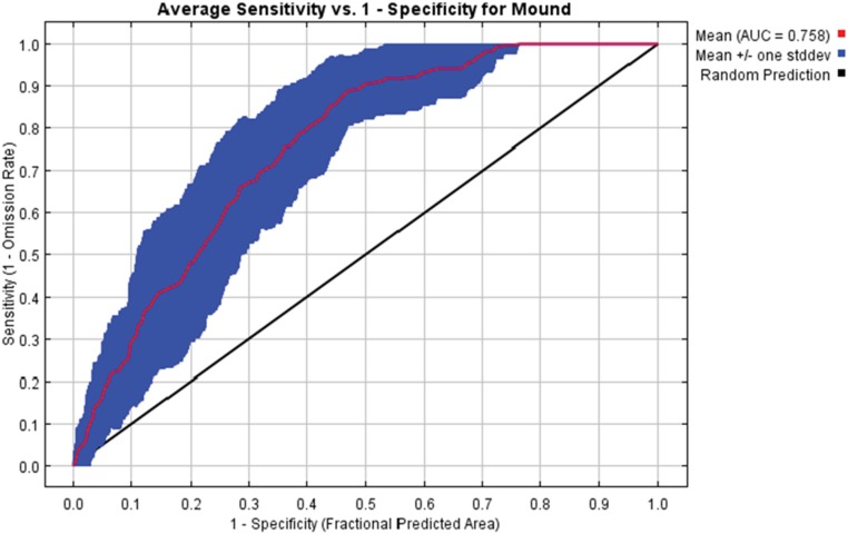
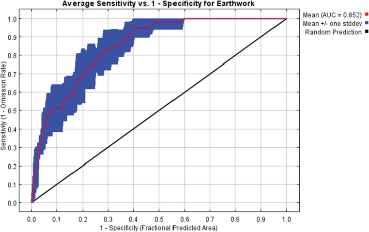
We performed 25-fold cross-validation of the model for mounds and 6-fold cross-validation of the model for enclosures. Folds were related to the total numbers of occurrence records. Mounds, with more occurrences, were split randomly into 25 equal-sized groups called “folds,” and the model was replicated 25 times, each time leaving out 1-fold, to test the performance of the model (enclosures with 6-fold). This process was advantageous, because all of the data points were used for model training and also, performance testing. We evaluated area under the curve (AUC) statistics, which indicated the predictive capacity of a model, and how much better (or worse) a given model performed compared with a random model. A model with AUC value greater than 0.75 can be considered as predicting the distribution of test points accurately (40). For mounds, the average across all runs AUC = 0.758, and for enclosures, the average across all runs AUC = 0.852, indicating that the model fit the data well and had a high predictive capacity (SI Text).
We conducted analyses to assess the relative importance of input spatioenvironmental variables to the predicted geospatial suitability of each monument type (40). An estimate of relative contribution of the spatioenvironmental variables to MaxEnt model fit was derived. In each of the training algorithm, the increase in regularized gain was added to the contribution of the corresponding variable or subtracted from it if the change to the absolute value of λ was negative (Table 1) (normalized to percentages). Jackknife tests for training and testing datasets were done. Training gain values were derived from points used to train the model, and test gain values were derived from occurrence points used to test the predictive capacity of the model. In running jackknife tests, each variable is excluded in turn, and a model was created with the remaining variables. Then, a model is created using each variable in isolation. Using these jackknife tests, we identified for each monument type which input variable produced the largest gain value when it was excluded and which one produced the largest gain value when it was used as a single predictor (SI Text). A response curve using each input variable alone for the MaxEnt model for mounds and enclosures was created (Fig. 3 and SI Text). These curves show the dependence of predicted suitability for the selected variable (40).
SI Text
Nominal Regression.
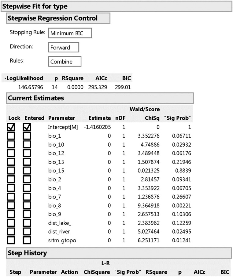
We conducted a stepwise nominal regression to serve as a nonspatial, independent analysis of the power of the input variables used in MaxEnt modeling to discriminate between mounds and enclosures; this was done to help control for the tendency of MaxEnt to overestimate geospatial distributions. Analysis was done in JMP. The overall results show that the input variables do separate the two features (Fig. S1).
Fig. S1.
Overall nominal regression results. AICc, corrected Akaike information criterion; BIC, Bayesian information criterion; nDF, degrees freedom.
The regression also identified three variables as sufficient to separate the features statistically: distance to a river, SRTM topography, and BIO8, which is the mean temperature of the wettest quarter [which is the same 3-mo segment as BIO10 (mean temperature of warmest quarter]. These three variables align with the variables found to be key in predicting mound and enclosure differential landscape distribution in MaxEnt (Fig. S2).
Fig. S2.
Variable nominal regression results. AICc, corrected Akaike information criterion; BIC, Bayesian information criterion; E/M, log odds from enclosures/mounds; RMSE, root mean squared error.
Multivariate Correlation Table.
We computed a multivariate correlation table for 13 input variables derived from 100,000 randomly generated points placed across the study area (Table S1). Table S1 provides a means of assessing linear relationships between each covariate used in the modeling. Of important note, distance to a lake and distance to a river have very low correlation coefficients across all variables. Analysis was done in JMP (Table S1).
Table S1.
Multivariate correlation table
| BIO1 | BIO10 | BIO12 | BIO13 | BIO15 | BIO2 | BIO4 | BIO7 | BIO8 | BIO9 | Dist_lake | Dist_river | Topo | |
| BIO1 | 1.000 | 0.979 | 0.258 | −0.203 | −0.561 | −0.392 | −0.721 | −0.738 | 0.667 | 0.791 | 0.184 | −0.125 | −0.514 |
| BIO10 | 0.979 | 1.000 | 0.238 | −0.225 | −0.454 | −0.276 | −0.569 | −0.604 | 0.755 | 0.713 | 0.191 | −0.155 | −0.422 |
| BIO12 | 0.258 | 0.238 | 1.000 | 0.549 | −0.383 | −0.110 | −0.179 | −0.254 | 0.014 | 0.333 | −0.173 | −0.006 | 0.078 |
| BIO13 | −0.203 | −0.225 | 0.549 | 1.000 | 0.217 | 0.302 | 0.089 | 0.183 | −0.488 | −0.188 | −0.278 | 0.061 | 0.335 |
| BIO15 | −0.561 | −0.454 | −0.383 | 0.217 | 1.000 | 0.749 | 0.733 | 0.825 | −0.157 | −0.792 | −0.139 | −0.114 | 0.608 |
| BIO2 | −0.392 | −0.276 | −0.110 | 0.302 | 0.749 | 1.000 | 0.657 | 0.831 | −0.084 | −0.601 | −0.245 | −0.171 | 0.701 |
| BIO4 | −0.721 | −0.569 | −0.179 | 0.089 | 0.733 | 0.657 | 1.000 | 0.942 | −0.127 | −0.773 | −0.107 | −0.024 | 0.660 |
| BIO7 | −0.738 | −0.604 | −0.254 | 0.183 | 0.825 | 0.831 | 0.942 | 1.000 | −0.219 | −0.823 | −0.181 | −0.041 | 0.697 |
| BIO8 | 0.667 | 0.755 | 0.014 | −0.488 | −0.157 | −0.084 | −0.127 | −0.219 | 1.000 | 0.362 | 0.246 | −0.195 | −0.167 |
| BIO9 | 0.791 | 0.713 | 0.333 | −0.188 | −0.792 | −0.601 | −0.773 | −0.823 | 0.362 | 1.000 | 0.125 | −0.043 | −0.624 |
| Dist_lake | 0.184 | 0.191 | −0.173 | −0.278 | −0.139 | −0.245 | −0.107 | −0.181 | 0.246 | 0.125 | 1.000 | −0.052 | −0.236 |
| Dist_river | −0.125 | −0.155 | −0.006 | 0.061 | −0.114 | −0.171 | −0.024 | −0.041 | −0.195 | −0.043 | −0.052 | 1.000 | −0.083 |
| Topo | −0.514 | −0.422 | 0.078 | 0.335 | 0.608 | 0.701 | 0.660 | 0.697 | −0.167 | −0.624 | −0.236 | −0.083 | 1.000 |
Topo, topography.
Mound MaxEnt Model AUC Analysis.
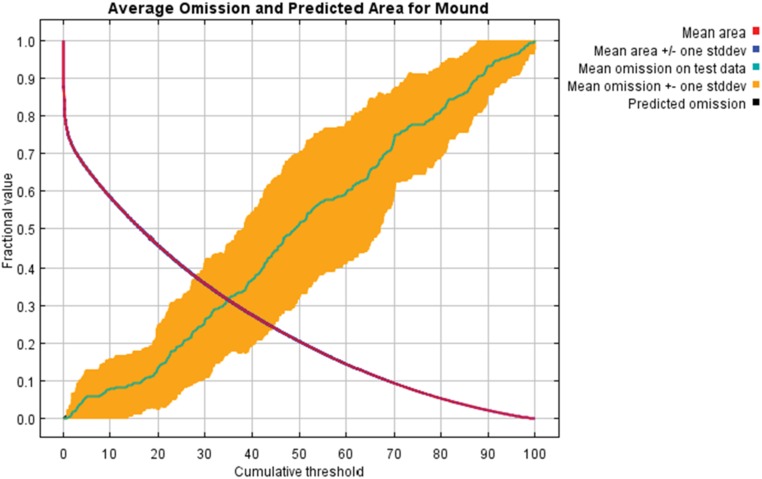
The test omission rate and predicted area as a function of the cumulative threshold averaged over the replicate runs were computed for mounds and are presented in Fig. S3.
Fig. S3.
Mound average omission and predicted area.
The receiver operating characteristic curve was produced with the same data, again averaged over the replicate runs. Note that the specificity is defined using predicted area rather than true commission (40). The average test AUC for the replicate runs is 0.758, and the SD is 0.059; this is shown in Fig. S4.
Fig. S4.
Mound receiver operating characteristic curve.
Earthwork Enclosure MaxEnt Model AUC Analysis.
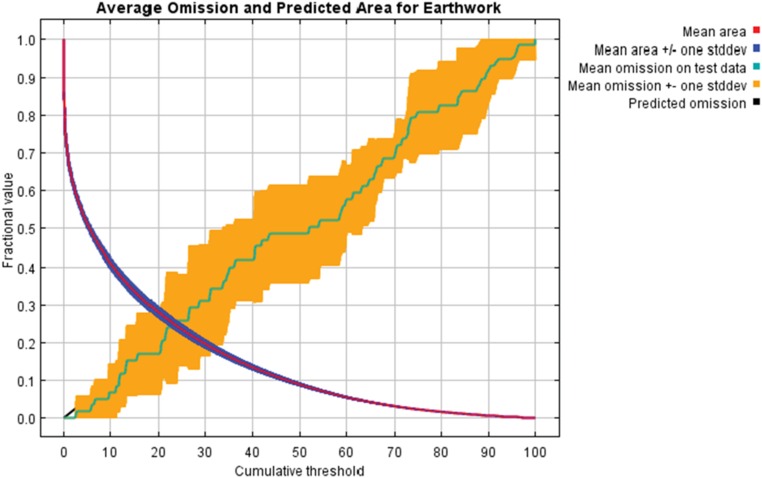
The test omission rate and predicted area as a function of the cumulative threshold averaged over the replicate runs were computed for earthworks and are presented in Fig. S5.
Fig. S5.
Enclosure average omission and predicted area.
The receiver operating characteristic curve was produced with the same data, again averaged over the replicate runs. Note that the specificity is defined using predicted area rather than true commission (40). The average test AUC for the replicate runs is 0.852, and the SD is 0.031; this is shown in Fig. S6.
Fig. S6.
Enclosure receiver operating characteristic curve.
Mound MaxEnt Model Variable Contribution Jackknife Tests.
Jackknife training and test gain assessments were done for mounds. Training gain values are derived from points used to train the model, and test gain values are derived from occurrence points used to test the predictive capacity of the model. Training and testing gain values with variable omitted are gain values of the model when the variable is excluded, and only variable is the gain value when the variable is used as a single predictor (Fig. S7).
Fig. S7.
Mound jackknife tests gain. Topo, topography.
Earthwork Enclosure MaxEnt Model Variable Contribution Jackknife Tests.
Jackknife training and test gain assessments were done for earthwork enclosures. Training gain values are derived from points used to train the model, and test gain values are derived from occurrence points used to test the predictive capacity of the model. Training and testing gain values with variable omitted are gain values of the model when the variable is excluded, and only variable is the gain value when the variable is used as a single predictor (Fig. S8).
Fig. S8.
Enclosure jackknife tests. Topo, topography.
Mound Variable Response Curves.
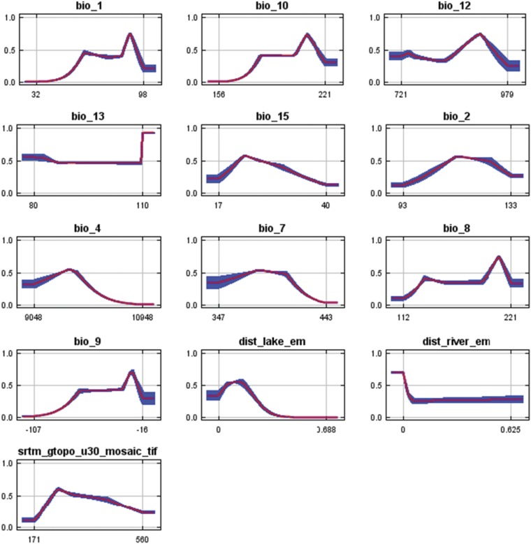
Response curves were created using each input variable alone for the MaxEnt model for mounds, which shows the dependence of predicted suitability as it patterns with the selected variable. The curves show the mean response of the replicate MaxEnt runs (red in Fig. S9) and ±1 SD (blue in Fig. S9). All temperature variables are shown in degrees Celsius by a factor of 10, all precipitation variables are in centimeters, distance to a lake and distance to a river are in kilometers and SRTM topography is in meters (Fig. S9).
Fig. S9.
Mound variable response curves.
Earthwork Enclosure Variable Response Curves.
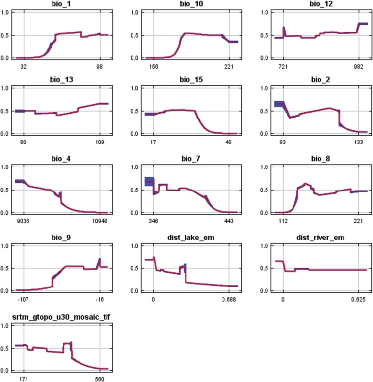
Response curves were created using each input variable alone for the MaxEnt model for enclosures, which shows the dependence of predicted suitability as it patterns with the selected variable. The curves show the mean response of the replicate MaxEnt runs (red in Fig. S10) and ±1 SD (blue in Fig. S10). All temperature variables are shown in degrees Celsius by a factor of 10, all precipitation variables are in centimeters, distance to a lake and distance to a river are in kilometers, and SRTM topography is in meters (Fig. S10).
Fig. S10.
Enclosure variable response curves.
Acknowledgments
We thank the University of Michigan Museum of Anthropology for access to state site files; Emma Pankey for her time in the archives; and Joyce Marcus, two anonymous reviewers, and the PNAS Editor for providing invaluable feedback on the paper. Research was supported by NASA Space Archaeology NNH11ZDA001N SAP Grant NNX13AO40G [to M.W.P. (principal investigator)]. An ACLS Digital Innovation Fellowship provided time for synthesis and writing (M.C.L.H.).
Footnotes
The authors declare no conflict of interest.
This article is a PNAS Direct Submission.
This article contains supporting information online at www.pnas.org/lookup/suppl/doi:10.1073/pnas.1603450113/-/DCSupplemental.
References
- 1.Kintigh KW, et al. Grand challenges for archaeology. Proc Natl Acad Sci USA. 2014;111(3):879–880. doi: 10.1073/pnas.1324000111. [DOI] [PMC free article] [PubMed] [Google Scholar]
- 2.Artursson M, Earle T, Brown J. The construction of monumental landscapes in low-density societies: New evidence from the early Neolithic of southern Scandinavia (4000-3300BC) in comparative perspective. J Anthropol Archaeol. 2016;41:1–18. [Google Scholar]
- 3.Bradley R. The Significance of Monuments: On the Shaping of Human Experience in Neolithic and Bronze Age Europe. Routledge; London: 1998. [Google Scholar]
- 4.Dillehay T. Monuments, Empires, and Resistance: The Araucanian Polity and Ritual Narratives. Cambridge Univ Press; Cambridge, United Kingdom: 2007. [Google Scholar]
- 5.Howey M. Mound Builders and Monument Makers of the Northern Great Lakes 1200-1600. Univ Oklahoma Press; Norman, OK: 2012. [Google Scholar]
- 6.French C. Archaeology. People, societies, and landscapes. Science. 2010;328(5977):443–444. doi: 10.1126/science.1186019. [DOI] [PubMed] [Google Scholar]
- 7.McCoy M, Ladefoged T. New developments in the use of spatial technology in archaeology. J Archaeol Res. 2009;17(3):263–295. [Google Scholar]
- 8.Jaynes ET. Information theory and statistical mechanics. Phys Rev. 1957;106(4):620–630. [Google Scholar]
- 9.Elith J, et al. Novel methods improve prediction of species’ distributions from occurrence data. Ecography (Cop.) 2006;29(2):129–151. [Google Scholar]
- 10.Dudik M, Phillips S, Schapire R. Maximum entropy density estimation with generalized regularization and an application to species distribution modeling. J Mach Learn Res. 2007;8(6):1217–1260. [Google Scholar]
- 11.Elith J, et al. A statistical explanation of MaxEnt for ecologists. Divers Distrib. 2011;17(1):43–57. [Google Scholar]
- 12.Phillips S, Dudík M. Modeling of species distributions with Maxent: New extensions and a comprehensive evaluation. Ecography (Cop.) 2008;31(2):161–175. [Google Scholar]
- 13.Phillips S, Anderson R, Schapire R. Maximum entropy modeling of species geographic distributions. Ecol Modell. 2006;190(3-4):231–259. [Google Scholar]
- 14.Franklin J, Potts AJ, Fisher EC, Cowling RM, Marean CW. Paleodistribution modeling in archaeology and paleoanthropology. Quat Sci Rev. 2015;110:1–14. [Google Scholar]
- 15.Svenning J-C, Fløjgaard C, Marske KA, Nógues-Bravo D, Normand S. Applications of species distribution modeling to paleobiology. Quat Sci Rev. 2011;30:2930–2947. [Google Scholar]
- 16.McMichael CH, et al. Predicting pre-Columbian anthropogenic soils in Amazonia. Proc Biol Sci. 2014;281(1777):20132475. doi: 10.1098/rspb.2013.2475. [DOI] [PMC free article] [PubMed] [Google Scholar]
- 17.Banks W, et al. Eco-cultural niches of the Badegoulian: Unraveling links between cultural adaptation and ecology during the Last Glacial Maximum in France. J Anthropol Archaeol. 2011;30:359–374. [Google Scholar]
- 18.d’Errico F, Banks W. Identifying mechanisms behind Middle Paleolithic an Middle Stone Age cultural trajectories. Curr Anthropol. 2013;54(Suppl 8):S371–S387. [Google Scholar]
- 19.Galletti C, Ridder E, Falconer S, Fall P. Maxent modeling of ancient and modern agricultural terraces in the Troodos foothills, Cyprus. Appl Geogr. 2013;39:46–56. [Google Scholar]
- 20.McMichael C, Palace M, Golightly M. Bamboo-dominated forests and pre-Columbian earthwork formations in south-western Amazonia. J Biogeogr. 2014;41(9):1733–1745. [Google Scholar]
- 21.Saatchi SS, et al. Benchmark map of forest carbon stocks in tropical regions across three continents. Proc Natl Acad Sci USA. 2011;108(24):9899–9904. doi: 10.1073/pnas.1019576108. [DOI] [PMC free article] [PubMed] [Google Scholar]
- 22.Milner G. The Moundbuilders: Ancient Peoples of Eastern North America. Thames & Hudson; New York: 2005. [Google Scholar]
- 23.Thomas C. Report on the Mound Explorations of the Bureau of Ethnology. 12th Annual Report of the Bureau of American Ethnology for the Years 1890-1891. Smithsonian Institute; Washington, DC: 1894. pp. 3–730. [Google Scholar]
- 24.Blitz J. Moundville. Univ Alabama Press; Tuscalossa, AL: 2008. [Google Scholar]
- 25.Gibso J. The Ancient Mounds of Poverty Point: Places of Rings. Univ Press of Florida; Gainsville, FL: 2001. [Google Scholar]
- 26.Pauketat T. Cahokia: Ancient America’s Great City on the Mississippi. Penguin Books; New York: 2009. [Google Scholar]
- 27.Sherwood S, Kidder T. The DaVinci’s of dirt: Geoarchaeological perspectives on Native American mound building in the Mississippi River basin. J Anthropol Archaeol. 2011;30:69–87. [Google Scholar]
- 28.Struever S. The Hopewell interaction sphere in riverine-western Great Lakes culture history. In: Caldwell J, Hall R, editors. Hopewellian Studies. Illinois State Museum; Springfield, IL: 1964. pp. 85–106. [Google Scholar]
- 29.Fitting J. The Archaeology of Michigan: A Guide to the Prehistory of the Great Lakes Region. 2nd Ed Cranbrook Institute of Science; Bloomfield Hills, MI: 1975. [Google Scholar]
- 30.Gaff D, Brashler J. The South Flats earthwork, 20MU2. MidCont J Archaeol. 2011;36(2):195–226. [Google Scholar]
- 31.Greenman E. Michigan mounds, with special reference to two in Missaukee County. Pa Mich Acad Sci Arts Lett. 1927;7:1–9. [Google Scholar]
- 32.Hinsdale W. Archaeological Atlas of Michigan. Univ Michigan Press; Ann Arbor, MI: 1931. [Google Scholar]
- 33.Lee T. The Parker Earthwork, Corunna, Ontario. Pa Archaeol. 1958;28(1):5–32. [Google Scholar]
- 34.Speth J. The Whorley Earthwork. Mich Archaeol. 1966;12(4):211–227. [Google Scholar]
- 35.Watts C. Cedar Creek Earthworks (AaHq-2), Essex County, Ontario. MidCont J Archaeol. 2016;41(1):1–25. [Google Scholar]
- 36.White A, McCullough R, McCullough D. Archaeological Investigations at Two Late Prehistoric Earthen Enclosures in Indiana. IPFW Archaeological Survey; Fort Wayne, IN: 2003. [Google Scholar]
- 37.Zurel R. Earthwork enclosure sites in Michigan. In: Halsey J, Stafford M, editors. Retrieving Michigan’s Buried Past: The Archaeology of the Great Lakes State. Cranbrook Institute of Science; Bloomfield Hills, MI: 1999. pp. 244–248. [Google Scholar]
- 38.Milner C, O’Shea J. The socioeconomic role of Late Woodland enclosures in Northern Lower Michigan. In: Mainfort R, Sullivan L, editors. Ancient Earthen Enclosures of the Eastern Woodlands. Univ Press of Florida; Gainesville, FL: 1998. pp. 181–201. [Google Scholar]
- 39.Howey M, O’Shea J. Bear’s Journey and the study of ritual in archaeology. Am Antiq. 2006;71(2):261–282. [Google Scholar]
- 40.Philips S. A brief tutorial in Maxent. Lessons Conserv. 2010;3:107–135. [Google Scholar]
- 41.Cleland C. The Inland Shore Fishery of the northern Great Lakes: Its development and importance in prehistory. Am Antiq. 1982;47(4):761–784. [Google Scholar]
- 42.Holman M, Lovis W. The social and environmental constraints on mobility in the Late Prehistoric Upper Great Lakes region. In: Barnard H, Wendrich W, editors. The Archaeology of Mobility: Old and New World Nomadism. Cotsen Institute of Archaeology; Los Angeles: 2008. pp. 280–306. [Google Scholar]
- 43.O’Shea J. Inland foragers and the adoption of maize agriculture in the Upper Great Lakes of North America. Before Farming. 2003;2(3):1–21. [Google Scholar]
- 44.Howey M, Palace M, McMichael C, Braswell B. Moderate-resolution remote sensing and geospatial analyses of microclimates, mounds, and maize in the northern Great Lakes. Adv Archaeol Pract. 2014;2(3):195–207. [Google Scholar]
- 45.Goldstein L. One-dimensional archaeology and multi-dimensional people: Spatial organization and mortuary analysis. In: Chapman R, Kinnes I, Randsborg K, editors. The Archaeology of Death. Cambridge Univ Press; Cambridge, United Kingdom: 1981. pp. 53–69. [Google Scholar]
- 46.Arnold B, Jeske R. The archaeology of death: Mortuary archaeology in the United States and Europe 1990-2013. Annu Rev Anthropol. 2014;43:325–346. [Google Scholar]
- 47.Yarnell R. Aboriginal Relationships Between Culture and Plant Life in the Upper Great Lakes Region. Univ of Michigan Museum of Anthropology; Ann Arbor, MI: 1964. [Google Scholar]
- 48.Blackbird A. History of the Ottawa and Chippewa Indians of Michigan. Ypsilantian Job Printing House; Ypsilanti, MI: 1887. [Google Scholar]
- 49.Halstead P, O’Shea J. Introduction. In: Halstead P, O’Shea J, editors. Bad Year Economics: Cultural Responses to Risk and Uncertainty. Cambridge Univ Press; Cambridge, United Kingdom: 1989. pp. 1–8. [Google Scholar]


