Significance
The notion that sudden impacts on shared international waters can be detected and quantified, even in a war zone, is important to scientists and policy makers, who have been stifled in the past by inaccessibility to such regions and the consequent inability to collect relevant data. Our study uses satellite imagery of war-torn Syria, showing how conflict and migration caused sudden reductions in Syrian agricultural land use and water use. An unexpected effect of the conflict was increased flow in the Yarmouk River to Jordan, which nonetheless remains one of the world’s most water-poor nations. The study illustrates that conflict and human displacement can significantly alter a basin’s water balance with dramatic effects on the transboundary partitioning of water resources.
Keywords: remote sensing, Landsat, reservoir, conflict, irrigation
Abstract
Since 2013, hundreds of thousands of refugees have migrated southward to Jordan to escape the Syrian civil war that began in mid-2011. Evaluating impacts of conflict and migration on land use and transboundary water resources in an active war zone remains a challenge. However, spatial and statistical analyses of satellite imagery for the recent period of Syrian refugee mass migration provide evidence of rapid changes in land use, water use, and water management in the Yarmouk–Jordan river watershed shared by Syria, Jordan, and Israel. Conflict and consequent migration caused ∼50% decreases in both irrigated agriculture in Syria and retention of winter rainfall in Syrian dams, which gave rise to unexpected additional stream flow to downstream Jordan during the refugee migration period. Comparing premigration and postmigration periods, Syrian abandonment of irrigated agriculture accounts for half of the stream flow increase, with the other half attributable to recovery from a severe drought. Despite this increase, the Yarmouk River flow into Jordan is still substantially below the volume that was expected by Jordan under the 1953, 1987, and 2001 bilateral agreements with Syria.
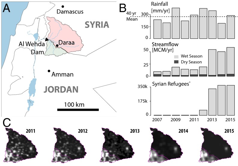
Disputes over scarce water resources rarely escalate into full-blown wars (1–4), but the impact of drought on water resources and agricultural land use is severely impacting the Middle East. The effect is most apparent in the current Syrian civil war, where poor governance and overreliance on intensive irrigation diminished the country’s ability to cope with a severe drought (5, 6). That drought, which hit the Middle East between 2006 and 2008 (6–8), had a detrimental effect on freshwater resources with consequent human impacts. The Syrian civil war was sparked by riots in the southern city of Dara’a (5), located in the Yarmouk River basin, a subbasin of the Jordan River watershed, which is shared with Jordan and Israel. Poor crop yields in Syria led to the collapse of the agricultural sector and large-scale migration to urban areas, contributing to economic hardship, political instability, and ultimately, armed conflict (5). The ensuing war caused a massive migration of Syrian refugees to neighboring countries, largely in 2013. The combined effect of conflict-related power outages and migration out of southern Syria is clearly visible in night-light images (Fig. 1C) that reflect population changes in the small cities and villages in the area (9). Data from the United Nations High Commission on Refugees (10) suggests that in excess of 369,000 people were driven out of the Syrian portion of the Yarmouk basin, an estimate that excludes the large number of unregistered refugees.
Fig. 1.
Yarmouk river flow increase coincides with refugee migration. (A) Map of the Yarmouk basin upstream of the Al-Wehda dam, with the Syrian and Jordanian parts of the basin (red and green), and the Al-Wehda dam, where stream flow is measured. (B) Time series of annual precipitation spatially averaged over the Yarmouk basin (Top, with long-term average represented as a dashed line), annual discharge volumes measured at Al-Wehda disaggregated by wet (October to May) and dry (June to September) seasons (Middle), and the cumulative number of registered refugees from the Syrian part of the basin (Bottom). (C) Annual average night-light intensity images of the Yarmouk region, from the Defense Meteorological Satellite Program Operational Line Scanner (DMSP-OLS) and Visible Infrared Imaging Radiometer Suite (VIIRS) satellite, illustrate the timing and magnitude of refugee migration out of the Syrian part of the basin. There is a clear decrease in night-light intensity in Syria when comparing images across three periods: (i) in 2011, before the war; (ii) in 2013, during the peak of refugee migration from Jordan to Syria; and (iii) in 2014–2015, during which the rate of migration decreases. In contrast, night-light intensity in Jordan during this entire 5-y period remained relatively constant. VIIRS images for 2014 and 2015 were downscaled and adjusted to match the resolution and average intensity (in the Jordanian portion of the basin) of DMSP-OLS images used for previous years.
This migration put major stress on Jordan’s infrastructure, including its water resources (11), a heavy burden for a country ranked among the most water-scarce in the world even before the refugee influx (12). However, the refugee crisis also coincided with an unexpected, rapid increase in flow in the Yarmouk River from Syria to the Al-Wehda reservoir on the Syria–Jordan border (Fig. 1), which feeds Jordan’s water supply system. The Yarmouk River is the primary tributary to the lower Jordan River and a strategic transboundary freshwater resource. The river has historically been the largest natural surface water source available to Jordan, providing a significant portion of the country’s surface water supply. The Al-Wehda dam, along the Jordan–Syria border, became operational in 2007. The reservoir captures much of the Yarmouk flow, serving as a significant water storage facility for Jordan. In the past several decades, the Yarmouk watershed upstream of the Al-Wehda dam has been extensively exploited by Syria with the construction of 21 dams to enable intensive agricultural irrigation, resulting in substantial flow decreases to downstream Jordan and Israel (Fig. S1D). After 2012, inflow records at Al-Wehda reservoir show a sudden reversal in this declining flow trend, an unexpected increase as rainfall declined between 2012 and 2014 (Fig. 1). However, there is a clear correspondence between the flow increase and the number of refugees migrating out of the Syrian side of the basin (Fig. 1). This correspondence suggests a potential relationship between civil conflict, land use, and water consumption in Syria, with consequent changes to the hydrological response.
Fig. S1.
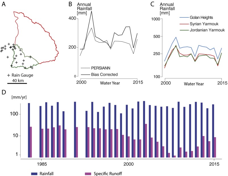
Rainfall. (A) Map of the Yarmouk basin with the location of the Jordanian rain gauges used to adjust remote sensing rainfall (n = 31). (B) Annual rainfall from the bias-corrected and original PERSIANN-CDR product (n = 16). (C) Bias-adjusted annual precipitation by region. Estimates, presented in log scale, show that despite differences in regional means, the trajectory (i.e., relative interannual change) of rainfall during the study period is comparable in Syria and in the two control regions (n = 16). (D) Annual rainfall and specific runoff volume over the 1983–2015 period (n = 30). Bias-corrected PERSIANN-CDR rainfall was spatially averaged over the Yarmouk basin, and specific runoff was computed by dividing the annual discharge volume (observed at the Maqarin/Al-Wehda gauge) by the surface area of the basin (6,138 km2). The effect of increasingly intensive irrigation water use in the upstream Syrian portion of the Yarmouk basin is visible in a downward trend in specific runoff (i.e., flow per unit area) starting in the mid-1990s, with no corresponding downward trend in precipitation. The downward stream flow trend reversed after 2011.
This study explores the impact of armed conflict and consequent Syrian refugee migration on land use and freshwater resources. We show that the abrupt increase in transboundary river flow is a consequence of rapid upstream changes stemming from the Syrian civil war. Results indicate that the Syrian conflict and refugee crisis caused a substantial decline in agricultural land use and irrigation water use, and a significant alteration in the management of the Syrian stored water supply system, which ultimately resulted in increased flow to downstream Jordan.
Water Resources Assessment in a War Zone
Reliable land use and hydrological data are essential to investigate the changes in Syria on transboundary river flow to Jordan, but collecting data in an active war zone is a major challenge. Satellite data are increasingly exploited during situations requiring rapid collection of data in environments that are difficult to access, such as for disaster response and emergency mapping (13). Here, we use satellite imagery to investigate causal relations between changes in land use and water resources during an armed conflict. We use Landsat 7 images to quantify temporal changes in Syrian land use and water reservoir storage. To test the causal effect of the refugee crisis on land and water resources, we compare changes observed in Syria with corresponding changes observed in nearby regions where irrigation and dam management were unaffected by the refugee crisis. This differences-in-differences approach (14) uses two non-Syrian regions as controls: (i) the Jordanian side of the Yarmouk basin to assess changes in irrigated agricultural land use (Fig. 2) and (ii) the Israeli-controlled Golan Heights to evaluate changes in water reservoir management (Fig. 3). These two neighboring regions are expected to have similar rainfall, land use, and reservoir storage variations as in the Syrian Yarmouk, but they primarily differ in that they have not experienced a massive emigration of refugees. The validity of using these regions as controls is supported by remote sensing observations (Figs. S1C and S2). The causal effect of migration on irrigated land areas and reservoir storage volumes is evaluated statistically by relating premigration and postmigration changes in Syria to changes in the control regions over the same periods. The analysis takes 2013 as a cutoff, which is the year when most refugees migrated (Fig. 1). Using this cutoff allows us to identify specifically the impacts of migration, and disentangle migration from other potential effects of the conflict that started in 2011.
Fig. 2.
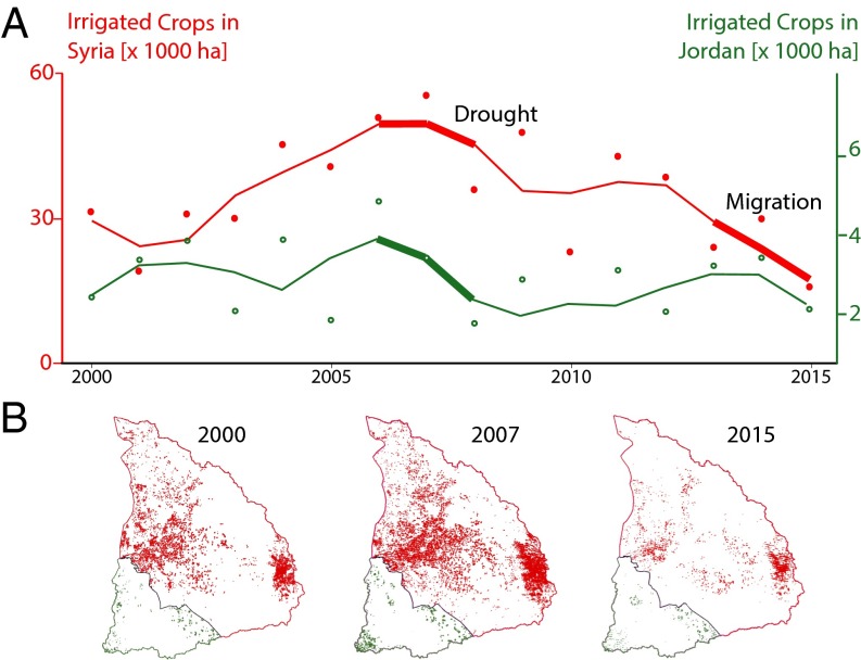
Remote sensing detection of irrigated regions. (A) Time series graphs of annual extent of irrigated areas in the Yarmouk basin, excluding irrigated olives, for Syria (red) and Jordan (green). Dots (n = 16) represent point estimates obtained from Landsat 7 imagery and used in the statistical analyses. Lines are obtained by a local polynomial regression fit (span = 0.5) to reduce observation errors and illustrate land use trends. Decreases in irrigated land surface corresponding to the 2006–2008 drought are clearly visible for both countries, whereas a second significant drop occurs only in Syria after 2012, during refugee migration. (B) Maps of irrigated areas for 2000, 2007, and 2015 (1 pixel = 30 × 30 m) illustrate the extent of the change in land use.
Fig. 3.
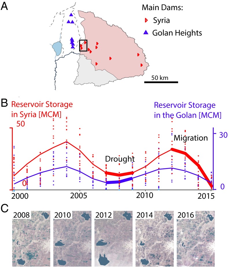
Remote sensing detection of reservoir storage. Time series estimates of water volume stored in the major reservoirs are presented for the Upper Yarmouk basin in Syria (A, red) and the Golan Heights (B, blue) (n = 189 for each region). Lines represent average annual storage, and monthly estimates are represented as dots. The effect of the 2006–2008 drought is visible for both regions as a local minimum in dammed-reservoir storage volume. A second decrease in reservoir storage was detected in both regions after 2012, but the decrease is significantly more dramatic in Syria, from which refugees fled. (C) Changes in reservoir storage are illustrated with satellite images of the westernmost reservoirs of southern Syria. The Landsat 7 images were taken at the end of the wet season (March and April) and are overlain by Normalized Difference Water Index water extent estimates (dark regions).
Fig. S2.
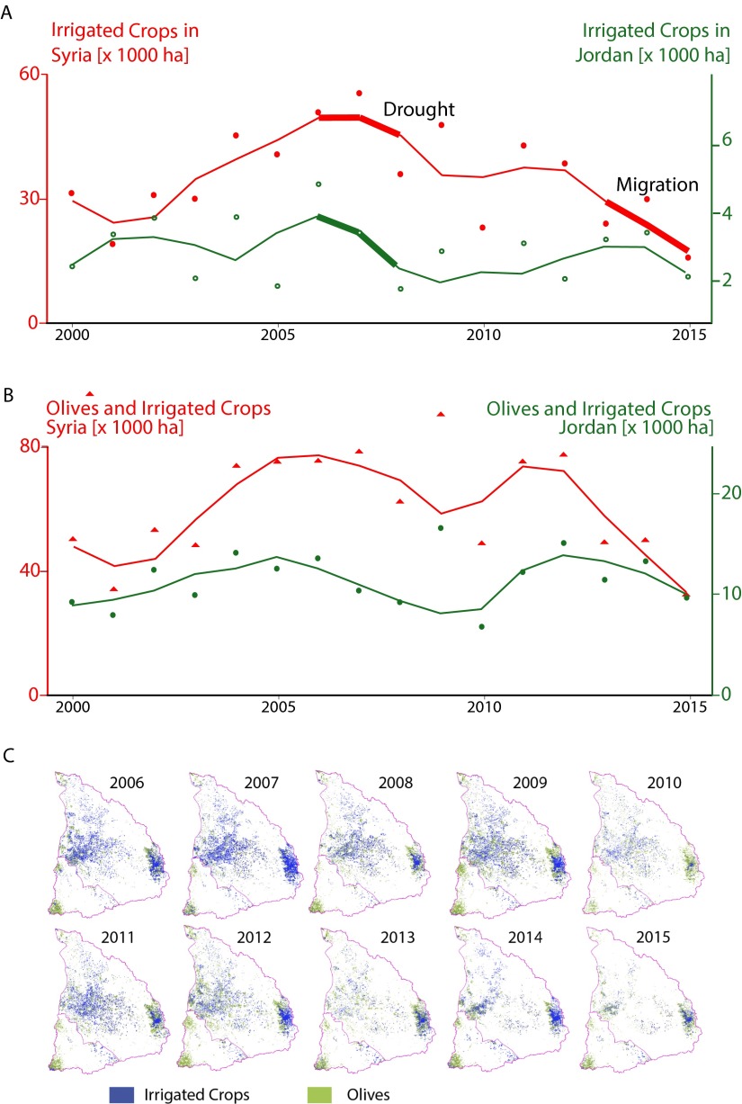
Land use classification results. Time series of irrigated area by country and calendar year, excluding (A) and including (B) irrigated and rain-fed olives (n = 16 per series), are presented. Although local polynomial regressions (span = 0.4) are used for illustrative purposes to minimize random observation errors on the figures (lines), the original point estimates obtained from Landsat 7 imagery (dots) are used for statistical inference. Both panels show an abrupt drop occurring predominantly in Syria after 2012, coinciding with the period of maximum refugee migration to Jordan, suggesting a detectable relation between migration and reduced agricultural water use that remains robust to systematic underestimation (A) and overestimation (B) of irrigated areas. (C) Annual maps of irrigated crops and olives (pixel size: 30 × 30 m).
Effect of Migration on Land Use
To evaluate the impact of migration on land use, irrigated land area was estimated at 30-m resolution using Landsat 7 multispectral satellite imagery. Vegetation indices commonly exploit the unique property of photosynthetic pigments to absorb red and emit near-infrared wavelengths of the electromagnetic spectrum. The Normalized Difference Vegetation Index (NDVI) measures increases in chlorophyll content, which is inversely related to water stress (15). We classified vegetation as irrigated cropland for those areas with high NDVI values during summer months (June to September) when precipitation is negligible. We further distinguished summer-irrigated crops from evergreen vegetation by evaluating the difference between median cloud-free NDVI values in the spring (January to May) and summer, bias-correcting to account for temporal variation in NDVI due to changing soil and atmospheric conditions (Materials and Methods). In Fig. 2, we generated maps of irrigated crop areas for the Jordanian and Syrian portions of the Yarmouk basin between 2000 and 2015 (see Fig. S2 for all years and Table S1 for confusion matrices). Irrigated areas increased in both countries between 2000 and 2006, followed by an abrupt drop during the following years, which corresponds to a regional drought. In Syria, irrigated area declined considerably after 2012, coinciding with the flight of Syrian refugees (Figs. 1B and 2 A and B). Notably, the post-2012 drop was much greater in Syria than in Jordan, suggesting that conflict and the flight of refugees caused a major reduction in farming and associated reduction in irrigation water use in Syria. Irrigation in Jordan remained unaffected by the influx of refugees, who settled predominantly in camps and cities outside of the Yarmouk basin. Using temporal changes in irrigated area in Jordan as a counterfactual scenario, results show a statistically significant [90% confidence interval (CI)] 47% decrease in irrigated land in southern Syria caused by the refugee crisis that started in 2013 (Table 1, column 1; interaction coefficient). This effect remains robust to systematic remote sensing classification errors, as discussed in Supporting Information. In contrast, no significant change was detected on the Jordanian side of the basin, as seen in the nonstatistically significant coefficient for the time dummy. The effect ceases to be statistically significant when setting 2011 and 2012 (when the civil conflict started) as cutoff years, respectively, instead of using 2013 (when most refugees migrated). This finding suggests that the changes in land use are more likely attributable to refugee migration than to other conflict-related causes.
Table S1.
Confusion matrices for 2014, 2009, and 2005
| Year | NI | I |
| 2014 | ||
| NI | 50 | 1 |
| I | 10 | 40 |
| 2009 | ||
| NI | 63 | 3 |
| I | 9 | 26 |
| 2005 | ||
| NI | 62 | 6 |
| I | 15 | 18 |
Matrices were constructed using 101 randomly sampled validation points. Columns represent outputs of the classification algorithm at these points, and rows represent ground truth determined using high-resolution satellite images. I, irrigated; NI, not irrigated.
Table 1.
Ordinary least squares regression coefficients for the differences-in-differences analysis reveal a significant negative effect of the refugee crisis (interaction coefficient) on irrigation and reservoir storage
| Independent variable | Dependent variable | ||
| Log irrigated area | Log reservoir storage | ||
| No olives | With olives | ||
| Country dummy (Syria) | 2.633*** (0.144) | 1.703*** (0.100) | 0.793*** (0.094) |
| Time dummy (post-2013) | 0.074 (0.235) | 0.013 (0.164) | −0.049 (0.152) |
| Interaction coefficient | −0.640* (0.333) | −0.390# (0.232) | −0.678*** (0.215) |
| Intercept | 7.877*** (0.102) | 9.345*** (0.071) | 2.096*** (0.070) |
| Counterfactual scenario | Jordan | Jordan | Golan Heights |
| Observations | 32 | 32 | 378 |
| R2 | 0.931 | 0.922 | 0.185 |
Exponentially transformed regression coefficients can be interpreted as relative changes in outcomes. SEs are shown in parentheses. #P < 0.11; *P < 0.1; **P < 0.05; ***P < 0.001.
Effect of Migration on Reservoir Levels
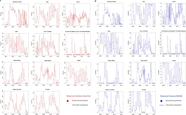
In addition to land use impacts, we investigated the relationship between refugee migration and Syrian reservoir management. Based on monthly cloud-free Landsat 7 composite images, we identified 21 Syrian-controlled surface water reservoirs in the Yarmouk basin, upstream of the Al-Wehda dam, and estimated the surface area of the 11 largest reservoirs for each month over the 2000–2015 period. These reservoirs account for 93% of Syrian storage capacity used for irrigation in the Syrian part of the Yarmouk basin upstream from the Al-Wehda dam. We estimated storage volumes from reservoir extents by relating topographic information from a high-resolution digital elevation model [Advanced Spaceborne Thermal Emission and Reflection Global Digital Elevation Model (ASTER GDEM), version 2] to local flooding frequencies observed on Landsat 7 images. All of the reservoirs included in the analysis are used for seasonal irrigation storage and were completely empty at least once during the Landsat coverage period (2000–2015), so this procedure allowed complete filling curves to be determined individually for each dam (Fig. S3), as described in Supporting Information.
Fig. S3.
Remotely sensed estimation of water extent surface area (A), and storage volume (B) time series of individual Syrian reservoirs. All considered reservoirs were empty (i.e., their surface area was not detectable by the remote sensing analysis) during a portion of the observation period (2000–2015), which allowed low-stage filling curves to be determined.
As a control, a similar analysis was conducted for the eight reservoirs operated by Israel in the Golan Heights. The effect of the 2006–2008 drought is apparent with a minimum in reservoir storage in both Syria and Israel (Fig. 3). Storage increased in both areas as the region recovered from drought during 2009–2012, before decreasing again during the low rainfall period of 2013–2015. This final decrease in stored water, however, was notably more substantial in Syria than in the Golan Heights, which suggests that Syrian reservoir storage was largely affected by changes in the country’s water management practices during the conflict. This effect is corroborated by a comparative difference analysis that revealed a statistically significant (99% CI) 49% decrease in reservoir storage in Syria for the 2013–2015 refugee migration period compared with the reservoir storage decrease in the Golan Heights, where no detectable change has been found during the same period (Table 1, column 3).
Attribution of Transboundary Flow Increases
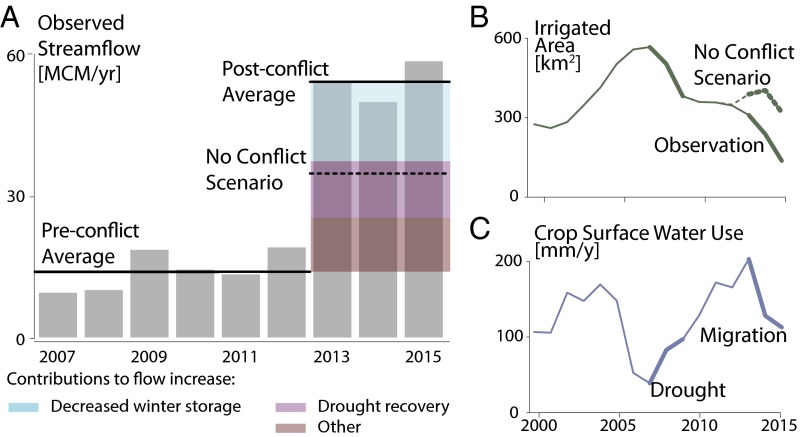
Finally, we evaluated the impacts of the refugee migration along with associated land use and reservoir storage changes on the hydrological response of the watershed. Measured inflows into the Al-Wehda reservoir on the Jordan border reveal a 340% increase in the annual flow after the onset of the refugee crisis (2013–2015) compared with the baseline period (2006–2012). We used regression analysis and water balance calculations to disentangle the effects of conflict-related changes in water demand, and the watershed’s natural recovery from the 2006–2008 drought (Fig. 4A).
Fig. 4.
Contributions to transboundary stream flow increase. (A) Annual stream flow volume observed into the Al-Wehda reservoir (gray bars). Averages for the 2007–2012 and 2013–2015 periods (solid black line) show a significant increase in runoff during the Syrian refugee migration. The graph is overlain by areas representing the proportions of flow increase related to reservoir management (blue) and drought recovery (purple) as determined by the winter water balance regressions (Table 2). Residual flow change remaining unexplained by the observed covariates is represented in brown (Supporting Information). (B) Time series of irrigated area (n = 16), with annual estimates from Landsat imagery (solid) and a counterfactual scenario with no conflict-related migration (dashed). (C) Aggregated water volume stored in reservoirs each year (n = 16), normalized by the area of irrigated land. The resulting water consumption rates represent the portion of crop water demand met by stored surface water.
Results suggest that drought recovery and decreased winter flow retention are responsible for 72% of the flow increase during the refugee migration period. Recovery from the 2006–2008 drought accounted for ∼30% of the flow increase, as revealed by a substantial increase in 4-y precipitation averages (Fig. S4C). As for flow retention, the analysis of Landsat 7 imagery also showed that Syrian dams retained considerably less runoff during the refugee migration period (2013–2015) compared with prior years. These changes predominantly occurred during the wet season (October to May), when the largest portion of the stream flow increase occurred (Fig. 1B). The decreased retention of wet-season floods during the refugee migration period accounts for another 42% of the observed flow increase reaching Jordan. Syrian dams are used to store winter runoff for summer irrigation, so the decreases in both reservoir storage and irrigated cropland during the refugee flight from Syria, as observed in Landsat 7 imagery, are likely related. This narrative is confirmed by the regression results presented in Table 2, which show that river flow is strongly correlated to refugee migration, even when controlling for short-term and long-term rainfall contributions (column 2). However, that correlation disappears when including changes in reservoir storage ( in the dependent variable (Table 2, column 3). This finding suggests that the correlation between river flow and refugee migration is primarily related to changes in winter reservoir storage. A detailed discussion of the causes of changes in Yarmouk River runoff is provided in Supporting Information.
Fig. S4.
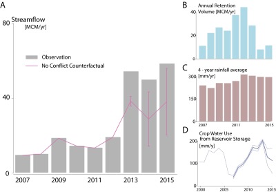
“No-conflict” counterfactual scenario. (A) Counterfactual scenario of Yarmouk stream flow, absent the Syrian refugee crisis, (n = 9) overlaid on annual stream flow observations. (D) Error bars are constructed by taking the upper and lower bounds in the determination of crop water use from reservoir storage (n = 16) to construct the stream flow counterfactual scenario. The upper and lower bounds, respectively, neglect irrigation return flows or neglect the contribution of subsurface water to summer discharge (which is assumed to be entirely formed of irrigation return flow). (B) Winter retention volumes in the Yarmouk basin estimated from Landsat 7 imagery. (C) Four-year averaged annual rainfall estimates from bias-corrected PERSIANN data, which are used as a proxy for subsurface flows and illustrate the watershed’s recovery from the 2007–2010 drought.
Table 2.
Ordinary least squares regression coefficients for the winter water balance suggest that reductions in winter storage in Syrian reservoirs explain the substantial increase in stream flow observed during the refugee crisis
| Independent variable | Dependent variable: winter flow (October–May), MCM⋅mo−1 | ||
| Q + ∆S | Q | Q + ∆S | |
| Controls for refugee migration | No | Yes | Yes |
| Refugees, 105 persons | 1.160*** (0.195) | 0.217 (0.527) | |
| Rain, mm⋅y−1 | 0.024*** (0.003) | 0.014*** (0.004) | 0.024*** (0.003) |
| Lagged rain 4-y average, mm⋅y−1 | 0.066** (0.031) | 0.020 (0.025) | 0.055 (0.050) |
| Intercept | −9.855** (3.988) | −3.694 (3.594) | −8.507 (6.175) |
| Observations | 81 | 81 | 81 |
| R2 | 0.501 | 0.491 | 0.502 |
Q, observed winter flow at Al Wehda; ∆S, remotely sensed increase in reservoir storage volume. Standard errors in parentheses are clustered by water year (October 1 to September 30). The winter water balance equation is described in Supporting Information. *P < 0.1; **P < 0.05; ***P < 0.01.
Despite their effects on stream flow, these changes in reservoir management practices are not entirely attributable to the impacts stemming from the Syrian conflict. Changes in reservoir storage were also detected in the Golan Heights, which serves as a control region (Fig. 3), and appear to be correlated to the changes in annual rainfall displayed in Fig. S1C. Similarly, winter reservoir storage is not the only pathway through which water management can affect the flow of the Yarmouk. For instance, the refugee crisis caused a significant decrease in irrigation demand, which likely increased the portion of reservoir releases making it back from irrigation canals to the stream during the summer. To identify the effect of the conflict on stream flow, we inspected land-use observations from the Jordanian side of the basin to construct a counterfactual scenario describing irrigation in Syria if the refugee crisis had not occurred (Fig. 4B). A counterfactual stream flow scenario was then constructed using annual crop demands for surface water estimated from satellite imagery (Fig. 4C) to determine the volume of water that would have been lost to irrigation had the refugees not migrated (Materials and Methods). It is noteworthy that unlike other irrigation sources (e.g., groundwater), surface-irrigation water would have otherwise resulted in runoff flowing into Jordan and would have been observed at the Al-Wehda gauge if not used for irrigation in Syria. Assuming a local average crop water use of 700 mm⋅y−1 (16), crop water use estimations presented in Fig. 4C suggest that only about 7–35% of irrigation demand is supplied by stored surface water, with the remainder being supplied by groundwater, surface water imports (Fig. S5), and direct precipitation. These ratios are in line with other published estimates of agricultural water use in the region, as discussed in Supporting Information. Despite the small relative contribution of surface water to irrigation volume, the flow counterfactual scenario suggests that about 48% of the stream flow increase between the two periods (2006–2012 and 2013–2015) is attributable to the rapid migration of Syrian refugees and subsequent abandonment of irrigated agriculture. Compared with the counterfactual scenario, the observed stream flow represents a 150% increase in the annual flow into the Al-Wehda reservoir along Jordan’s northern border (Fig. 4A).
Fig. S5.
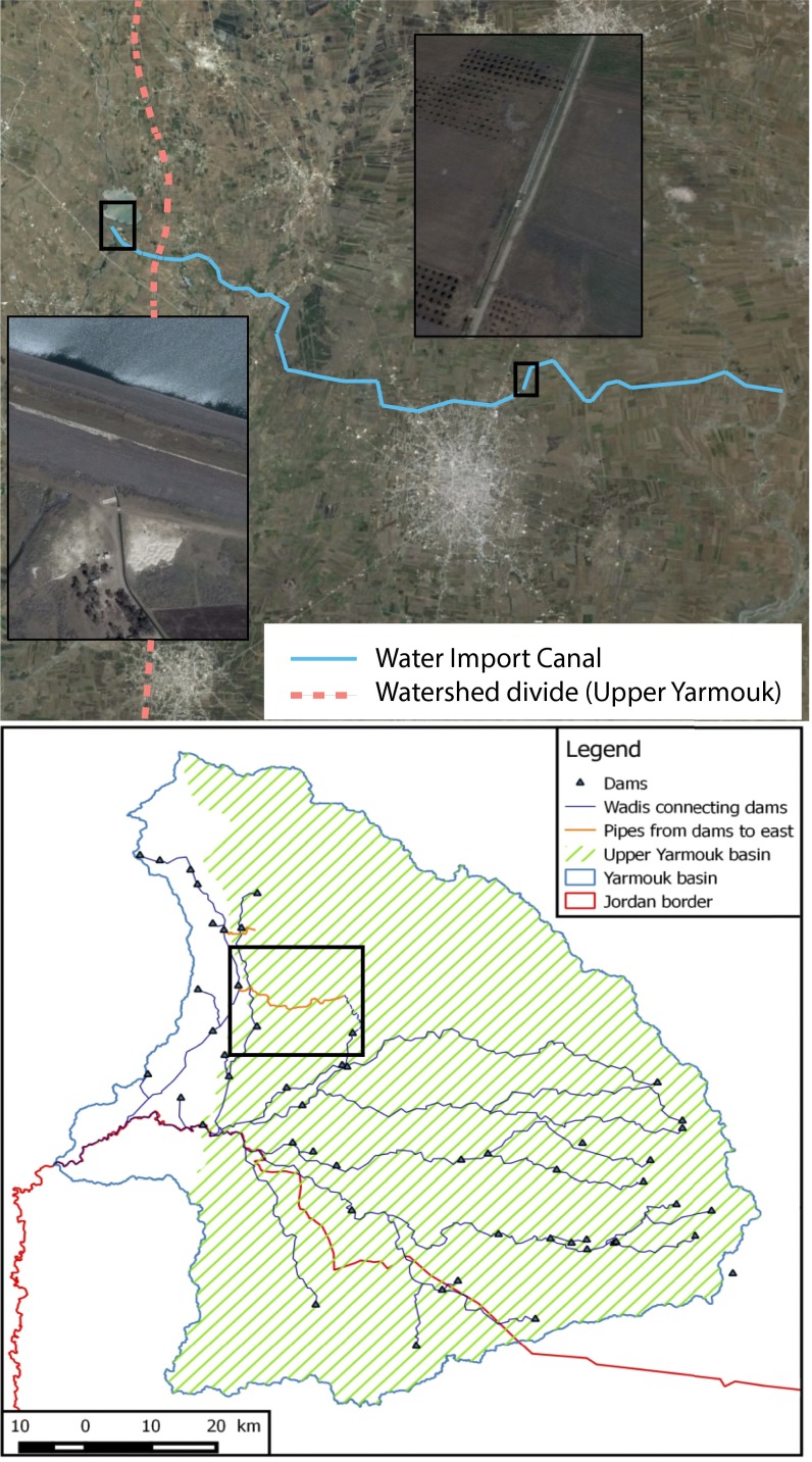
Evidence of surface water imports. High-resolution imagery suggests that irrigation water was imported to the Upper Yarmouk basin (Bottom, eastern region green pattern) from reservoirs along conduits feeding the Yarmouk downstream of Al-Wehda (Bottom, western region blue outline). (Top) Water import canal is visible on Google Earth imagery [including local areas showing the intake structure and a section of the canal (Insets)]. The imported water may constitute an important source of irrigation water (along with groundwater, rainfall, and stored surface water) and may produce measurable runoff into the Al-Wehda reservoir as irrigation return flow.
These results suggest that the Syrian conflict and subsequent refugee migration caused stream flow to increase by primarily affecting irrigation demand and reservoir management practices within the basin. The abnormal recent decrease in Syrian water retention detected on satellite imagery (Fig. 3) is substantiated by anecdotal evidence from the field, which points toward the underuse or decommissioning of dams due to targeted military operations (17) and poor operational management (18). In effect, as of 2015, most dams in the basin were controlled by rebel forces that lacked the proper information, technical knowledge, energy access, and institutional cohesion to manage reservoirs in an efficient and coordinated manner (18). This situation, along with decreased institutional capacity that might have prevented illegal well drilling after the beginning of the conflict, likely contributed to an increased relative reliance on groundwater versus surface water to supply the irrigated agriculture that remained in the region (18). This observation is consistent with our remote sensing analysis showing a decreasing relative contribution of surface water to crop irrigation on a per area basis after 2013 (Fig. 4C). However, this increased relative reliance on groundwater versus surface water is counteracted by an overall decrease in irrigated area, making it unclear whether total groundwater withdrawals have increased or decreased due to the war. In addition, the effect of the conflict on cropping patterns and domestic water use, both of which affect total groundwater use, remains uncertain.
Increases in summer runoff are insignificant [<2 million cubic meters (MCM) per year for the four summer months] compared with the rise of wet-season runoff after 2013 (48 MCM⋅y−1 for nonsummer months), which dominates the change in total annual transboundary flow volume as apparent in Fig. 1. This finding indicates that changes in base flow (contributed by groundwater) are insignificant in terms of explaining the increase in surface water runoff highlighted in our analysis. Furthermore, the slight increases in summer flows are also insignificant compared with historical summer flows observed in decades past, before intensive water development by the Syrians. This finding suggests that changes in groundwater extraction or groundwater recharge patterns due to the war have not resulted in substantial groundwater system recovery or a significant increase in transboundary base flow contribution in the short term.
Summary and Implications
The Syrian portion of the Yarmouk basin, which is a major subbasin of the Jordan River, has been the epicenter of an ongoing, devastating civil war involving the migration of hundreds of thousands of Syrian refugees. This study sheds light on the indirect effects of that conflict on freshwater resources through the impacts of refugee migration, land use change, and wartime changes in water management practices. The analysis revealed that a 47% reduction in irrigated land area in the Syrian portion of the Yarmouk basin and a 49% decrease in reservoir storage are attributable to the conflict and subsequent migration. These changes, in turn, account for 48% of the 3.5-fold increase in transboundary surface water flow to Jordan observed from the 2006–2012 premigration period to the 2013–2015 postmigration period. Although the relation between upstream water use and downstream water availability has been studied for transboundary watersheds (19), we are not aware of any study that has quantified transboundary water resource changes resulting from the indirect impacts of an armed conflict. Such impacts are difficult to quantify due to lack of data access in an active war zone. In the absence of ground data, we rely on satellite remote sensing analysis to deduce the impacts of conflict on land use and reservoir management. The analysis reveals that armed conflict resulted in significant changes to land use and water management in Syria, and, ultimately, in an unexpected increase in transboundary flow to neighboring Jordan, a severely water-scarce country receiving many of the refugees escaping the war.
It is noteworthy that in the near term, the unintended “spillover” effect to Jordan represents a modest irrigation water benefit that minimally offsets the immediate freshwater needs of hundreds of thousands of Syrian refugees received by Jordan. The Yarmouk inflows are conveyed from the Al-Wehda dam for irrigation in the Jordan Valley rather than to the eastern highlands, where the vast majority of the urban population, including the Syrian refugees, reside. In the long term, should the observed reduction in Syrian irrigated agriculture persist, the recent increase in transboundary flows would have a positive impact on Jordan’s overall water resource availability, because the Yarmouk flows in excess of 25 MCM⋅y−1 could be used by Jordan, per the 1994 bilateral agreement between Jordan and Israel (20). Even then, however, such an increase would only reflect a slight shift back toward flow volumes expected by the Jordanians under the 1953, 1987, and 2001 bilateral agreements with Syria (21–23).
The case study of the Syrian civil war and its impact on the Yarmouk basin’s water resources reveals the potential interactions between human displacement, land use change, and reservoir management for a region undergoing conflict. Although much research has focused on either the impacts of water scarcity on conflict (1, 4) or the direct effect of violence on water infrastructure (24), our analysis shows that human conflict can also significantly alter the basin-scale water balance with potentially important water supply ramifications for water users in the basin. This work also illustrates how innovative methodologies combined with remote sensing data can be used to evaluate hydrologic and land-use dynamics in a conflict zone, and more generally for the acquisition of critical information for water management in unstable, inaccessible, or noncooperative settings.
Materials and Methods
Remote Sensing.
Rainfall in the Yarmouk basin is highly spatially variable and strongly affected by local topography (25). We used a remote sensing precipitation product [Precipitation Estimation from Remotely Sensed Information Using Artificial Neural Networks (PERSIANN)-CDR (26)] to resolve spatial trends and estimate precipitation in Syria, where rain gauge data are unavailable. PERSIANN-CDR is available as a global 1.5°-resolution gridded product of monthly precipitation (1983 to present) and is freely accessible on Google Earth Engine (27). We used Google Earth Engine to compute a time series of spatially averaged monthly precipitation estimates over the entire basin, bias-correcting based on local gauge data (as described in Supporting Information).
We detected irrigated crops using monthly NDVI images (15) that were computed using the top of atmosphere (TOA) (28) reflectance composite of Landsat 7 imagery (bands 3 and 4), which we bias-corrected to account for temporal fluctuations in atmospheric and soil conditions (Supporting Information). We classified irrigated areas by segmenting dry-season NDVI images (29) using thresholds that were determined by manual adjustment using visual inspection of high-resolution background imagery provided in Google Earth Engine (Fig. S6). Several recent studies have successfully applied remote sensing techniques to assess lake volumes based on vegetation (30, 31) and water (32) indices. The Modified Normalized Difference Water Index (MNDWI) (32) uses the green and medium infrared bands of Landsat 7 images at 30-m resolution to detect open water, which we found to detect open water in the Yarmouk basin more reliably than the NDVI used in other studies (30, 31). MNDWI images computed from weekly cloud-free Landsat 7 TOA reflectance composites were used to determine the monthly extent of the 11 largest reservoirs upstream of the Al-Wehda dam at the Jordan border. These reservoirs, listed in Table S2, are all located in Syria and account for 93% of Syrian capacity used for irrigation in the Syrian portion of the Yarmouk basin. Open-water pixels were detected by applying a threshold on MNDWI images, and classified pixels were corrected for image-striping defects (Supporting Information) and aggregated to form monthly composite images of maximum water extent. Reservoir volumes were finally obtained by constructing filling curves based on remotely sensed topographic data (ASTER GDEM2) and flooding frequencies determined from Landsat imagery (Supporting Information). The approach was tested on the Al-Wehda reservoir, for which in situ storage observations are available from the Jordanian Ministry of Water and Irrigation (Fig. S7).
Fig. S6.
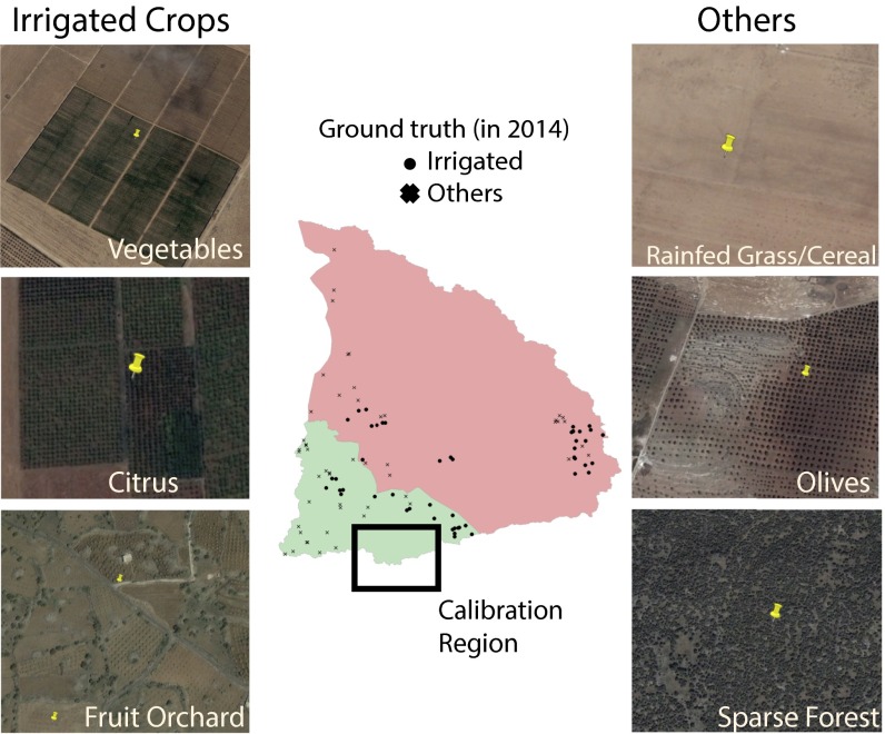
Determination of validation points using high-resolution imagery. The map in the center displays the location of the 101 randomly sampled validation points used to construct the confusion matrices, as well as the region of the basin used to determine thresholds in adjusted Normalized Difference Vegetation Index. The surrounding Google Earth screen shots illustrate the use of high-resolution imagery as ground truth for validation points.
Table S2.
Characteristics of the 11 Syrian dams upstream of Al-Wehda that are considered in the analysis
| Name | Capacity, MCM | Location |
| Saham al-Jawlan | 20 | 35.91°E 32.80°N |
| Sheikh Miskin | 15 | 36.12°E 32.87°N |
| Dar a al-Sharqi | 15 | 36.11°E 32.60°N |
| Sahwat al-Khadr | 8.75 | 36.70°E 32.58°N |
| Tasil | 6.65 | 35.97°E 32.88°N |
| Roum | 6.4 | 36.66°E 32.72°N |
| Adwan | 5.85 | 36.01°E 32.77°N |
| Al-Ghar | 5.5 | 35.91°E 32.84°N |
| Al-Ghariyah al-Sharqiyah | 5 | 36.29°E 32.67°N |
| Ebtaa kabeer | 3.5 | 36.11°E 32.82°N |
| Tafas | 2.1 | 36.04°E 32.76°N |
Fig. S7.
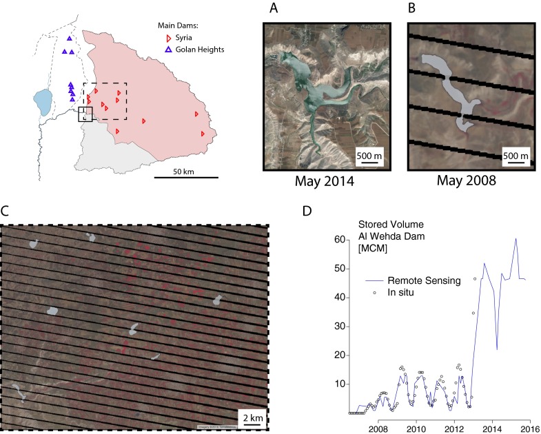
Remote sensing determination of reservoir areas. (A and B) Extent of the Al-Wehda reservoir at different filling stages. When near full (A, Google Earth image from 2014), the reservoir fills narrow side gorges and exhibits a complex geometry, whereas in the early filling stages (B, Landsat 7 imagery from 2008), the reservoir only fills the main valley. In the map (Top Right) and C, early-stage filling at Al-Wehda exhibits simpler geometry and is more similar to the rest of the reservoirs considered in the analysis, which are all located in the basalt plains to the north. (B and C) Characteristic striping defect affecting Landsat 7 imagery in the region, seen as black lines in the displayed images. (D) Remote sensing storage estimates (n = 63) against in situ storage observations at Al-Wehda reservoir (n = 83). Results suggest that the remote sensing procedure reliably reproduces monthly reservoir storage between 2006 and 2012 at the early filling stages of the reservoir.
All remote sensing procedures used to quantify rainfall, irrigated crop area, and reservoir storage were successfully validated against local in situ observations, as described in Supporting Information.
Change Attribution.
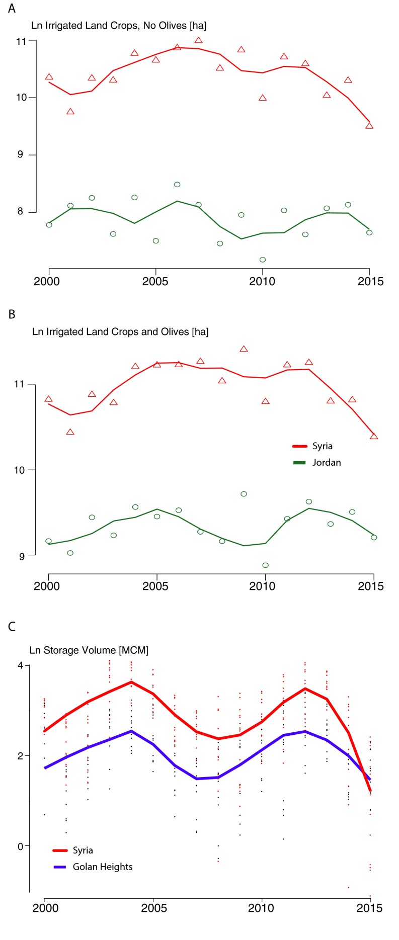
We use a differences-in-differences strategy (14) to identify the causal effect of the refugee crisis on changes in land use and reservoir management practices. The approach was implemented in a statistical framework by regressing the outcomes (measured in all regions in all periods) against a regional dummy (Syria or the control region), a time dummy (before or after the refugee crisis), and their interaction. For the purpose of our analysis, we model the refugee crisis as a shock occurring immediately before the calendar year 2013, and consider log-transformed outcomes in the regressions. This model allows exponentially transformed regression coefficients to be interpreted as relative changes in outcomes. The causal interpretation of these results hinges on the assumption that irrigated land use and reservoir storage have similar trajectories in Syria and their respective control region, which did not experience a refugee crisis. Under these conditions, any factor affecting irrigated land use or reservoir management that is specific to Syria but does not change concurrently with refugee migration or that may change during the refugee crisis but at a rate that is uniform across the regions is netted out during the estimation. This assumption is strongly supported by remote sensing observations obtained for each region, which show time series of irrigated land area and stored water volume that have similar shapes for each log-transformed outcome before 2013 (Fig. S8).
Fig. S8.
Time series of irrigated land areas by region representing the data used in the differences-in-differences analysis (n = 16 per series for land use and n = 189 per series for reservoir storage): natural log (Ln) irrigated areas without (A) and with (B) olives and Ln storage volume (C). Dots represent point estimates obtained from Landsat 7 imagery, and lines are obtained by local polynomial regression fitting (span = 0.5). All three panels suggest that the considered outcomes would follow similar trajectories in Syria and in the control region absent the refugee crisis, as seen in the similar shapes of the curves before 2013.
We consider the monthly water balance to relate the changes in irrigation practices to the substantial increase of the Yarmouk River flow at the Al-Wehda gauge that occurred simultaneously with the refugee migration. During the wet winters, reservoirs are predominantly used for flood abatement purposes and to retain water for summer irrigation; dams are located on stream channels, so any runoff water that is not retained in reservoirs directly flows as runoff and reaches the Al-Wehda gauge at the outlet of the basin. We expressed the direct relation between reservoir storage and stream flow runoff in a water balance equation (Supporting Information), and used the linear regression framework to test whether the large increase in winter river flow during rapid refugee migration was explained by changes in winter retention volumes in Syrian reservoirs. To do so, monthly estimations of the number of refugees fleeing the Syrian portion of the Yarmouk basin were determined using data from the United Nation High Commission on Refugees (Fig. S9), as described in Supporting Information.
Fig. S9.
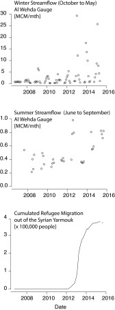
Monthly river flow observations suggest substantial increases in both winter (Top, n = 72) and summer (Middle n = 36) runoff that occurred during the period of rapid migration of refugees out of the basin (Bottom, n = 108). Data from the Maqarin flow gauge were obtained from the Ministry of Water and Irrigation, Hashemite Kingdom of Jordan. Migration data were obtained from the UNHCR (10) and include refugees originating from the Yarmouk basin (Dara’a and As Suweyda governorates) and registered in Jordan or Lebanon.
Finally, to construct a counterfactual scenario for irrigation, we first performed a panel regression analysis to estimate the effect of refugee migration on irrigated land in the Syrian Yarmouk. This relation allowed us to estimate irrigated area in the Syrian Yarmouk in a hypothetical scenario that assumes the migration of refugees did not occur (Fig. 4B). We then estimated crop use of stored surface water based on remotely sensed observations of reservoir storage and irrigated land areas (Table S3), as described in Supporting Information.
Table S3.
Origin and quantity of irrigation water use in the Upper Yarmouk basin
| Origin | Quantity, mm⋅y−1 | Source |
| Reservoir storage | 50–250 | This study, using Landsat 7 imagery |
| Groundwater | 325–650 | UN-ESCWA (34) |
| Rainfall | 238 | This study, using PERSIANN rainfall and observed discharge from the 1980s |
| Water imports | 200 | This study, using a SWAT model |
| Total | 813–1,338 |
SWAT, Soil and Water Assessment Tool; UN-ESCWA, United Nations Economic and Social Commission for Western Asia.
1. Bias Correction of PERSIANN Precipitation
Precipitation in the Yarmouk basin is strongly seasonal and orographic. Moisture is brought inland from the Mediterranean by prevailing westerly and southwesterly winds in the winter and condenses, passing over the coastal ranges west of the basin (25). Consequently, rainfall is highly spatially variable and strongly affected by local topography. We used a remote sensing precipitation product [PERSIANN-CDR (26)] to resolve spatial trends and estimate precipitation in Syria, where rain gauge data are unavailable. The PERSIANN algorithm predicts rainfall using cloud-top temperatures from geostationary infrared satellite data (Gridded Satellite-B1) and hourly surface rain rates (National Centers for Environmental Prediction radars), and it uses 2.5°-resolution gridded rainfall from Global Precipitation Climatology Center (GPCC) gauges for monthly bias adjustment. The PERSIANN-CDR is available as a global 1.5°-resolution gridded product of monthly precipitation (1983 to present) and is freely accessible on Google Earth Engine (27). We used Google Earth Engine to compute a time series of spatially averaged monthly precipitation estimates over the entire basin. By affecting the correlation between cloud-top temperature and precipitation, orographic effects introduce downward biases in remote sensing precipitation estimates (33). These biases are inherently local and tend to be poorly adjusted by GPCC gauges in regions where gauges are scarce (34). The GPCC dataset does not include observations from Syrian and Jordanian gauges after 2004 (35). We corrected for these biases using monthly precipitation records from 31 local gauges in neighboring Jordan that are maintained by the Ministry of Water and Irrigation of Jordan (Fig. S1A). Gauge observations were averaged spatially over the Jordanian portion of the Yarmouk basin using inverse distance weighted interpolation and compared against the corresponding PERSIANN-CDR estimates (also averaged over the Jordanian Yarmouk basin) to quantify monthly biases. The computed biases were then used to correct monthly rainfall estimates over the whole basin derived from the PERSIANN-CDR product, under the assumption that monthly biases are uniform over the 6,138-km2 area of the Yarmouk basin.
2. Bias Correction and Classification of NDVI Images
To account for temporal fluctuations in atmospheric and soil conditions, monthly NDVI images were adjusted by matching average NDVI values computed over a 5-km2 swath of bare soil in the Jordanian desert directly south of the Yarmouk basin (center at 32.36°N, 36.27°E)
where is the average NDVI computed in the bare-soil area for a given month and is the average NDVI in the bare soil area over the whole study period (2000–2015).
Rainfall in the Yarmouk basin is subject to strong seasonal fluctuations. Less than 2% of precipitation occurred between June and September during 2000–2015; thus, given minimal summer precipitation, we applied a threshold to the adjusted NDVI values, identifying vegetated areas as irrigated during summer months if they exceed the NDVI threshold. An additional threshold approach was applied to the difference between summer and winter vegetation to avoid misclassifying evergreen vegetation as irrigated crops, as suggested by Wu and De Pauw (29), which is the only published remote sensing assessment of irrigated agriculture in Syria to our knowledge. Thus, in any given year, a pixel was classified as irrigated crop if (i) the summer (June–September) median adjusted NDVI exceeds 0.18 and (ii) the summer median adjusted NDVI exceeds the spring (January–May) median adjusted NDVI by at least 0.035. Both thresholds were determined by manual adjustment using visual inspection of high-resolution background imagery provided in Google Earth Engine.
3. Validation of Remote Sensing Analysis
We ran a cross-validation analysis to the robustness of the bias-correction procedure for remotely sensed rainfall to gauge scarcity. Annual rainfall over the Jordanian part of the basin predicted using a random sample of 50% of the gauges was compared against “true” annual rainfall from all available gauges to bias-correct the PERSIANN-CDR. We obtained a root mean squared error of 63 mm⋅y−1 over 1,000 repetitions, for an average annual rainfall of 277 mm⋅y−1 over the 2000–2015 period. A larger root mean square error of 202 mm⋅y−1 was found when using precipitation from the original PERSIANN-CDR dataset. The location of the available rainfall gauges and bias-corrected rainfall estimates by region are displayed on Fig. S1.
To validate the land use classification algorithm, we used the high-resolution background imagery provided in Google Earth Engine to determine the vegetation cover of 1,000 random points within the basin by visual inspection (Fig. S6). A stratified random subset of 101 validation points (50 points for irrigated vegetation and 51 points for natural vegetation or bare soil) was used to validate classification results from 2014 (when the high-resolution imagery displayed as background in Google Earth Engine was taken), revealing an expected accuracy of 89%. To avoid sampling biases in validation performance, validation points were sampled outside of the region of the basin used to determine the NDVI thresholds used to detect irrigated crops (Fig. S6). Our results also suggest that 2.3% of the Jordanian side of the Yarmouk basin is irrigated, which compares well with the 2.8% value (excluding olives) reported by Al-Bakri et al. (16). The study by Al-Bakri et al. (16) is, to our knowledge, the only other recent land use assessment of the region, but it only covers the Jordanian portion of the Yarmouk basin. We also relied upon a historical database of high-resolution images available in Google Earth to assess classification accuracies before 2014. The actual vegetation cover for the 101 validation points was identified for 2005 and 2009, when high-resolution images were available for the entire basin, and compared with the corresponding classification maps, resulting in expected accuracies of 79% and 88%, respectively. The corresponding confusion matrices are presented in Table S1. This performance is comparable to the accuracy of 87% obtained by Al-Bakri et al. (16) for 2014 using supervised classification.
Remote sensing estimates of reservoir storage were validated against in situ observations for the Al-Wehda reservoir, provided by Jordan’s Ministry of Water and Irrigation. However, the Al-Wehda reservoir is located in a deep gorge with uniquely complex geometry. At high storage values, water inundates side valleys with complex dendritic geometry that cannot be properly resolved with the available remote sensing observations, indicating that the filling curve will likely perform poorly at higher volumes. This setting differs significantly from the geometry of the Syrian and Israeli dams considered in the analysis, which are located on the comparatively flatter topography of the basalt plateau to the north (map in Fig. S7) and with fitting curves that are expected to be much smoother. To address this difference, we use the subset of in situ storage observations recorded for Al-Wehda between 2006 and 2012. This period corresponds to the early filling stage of the Al-Wehda reservoir, before most side valleys were inundated, and represents the filling curve of the considered Syrian and Israeli dams sufficiently well for our purpose. The validation reveals a coefficient of determination R2 = 0.86 on monthly reservoir storage (Fig. S7C).
4. Cloud Detection and Classification of MNDWI Images
Clouds were first detected using the rudimentary cloud scoring algorithm available on Google Earth Engine. The algorithm assigns a score to each pixel by taking the minimum of several empirical indicators of cloudiness computed from the bands of the Landsat 7 Enhanced Thematic Mapper Plus (ETM+) sensor (36). Pixels with a cloud score exceeding 0.2 were masked from each image. The MNDWI (32) was then computed for the remaining pixels using the green and first short-wave infrared bands (bands 2 and 5) of the ETM+ sensor. Pixels with an MNDWI exceeding a threshold of 0.15 were then classified as open water, and classified pixels were corrected for image-striping defects (Supporting Information, 5. Correction of Landsat ETM+ Image-Striping Defect) and aggregated to form monthly composite images of maximum water extent.
5. Correction of Landsat ETM+ Image-Striping Defect
Due to a defect in the ETM+ sensor, Landsat 7 images taken after 2003 are affected by characteristic diagonal black stripes containing no data. Although these defects only marginally affect annual land use classification images because their location changes over time, they can have a significant effect on the monthly characterization of local features, such as the surface area of reservoirs. To address this issue, we determined the extent of water bodies within the stripes using morphological filters as follows:
-
i)
Each pixel was reclassified as a “water body” if any pixel within a 45-m radius was previously classified as a water body. This operation was iterated twice to interpolate reservoir extents across the stripes.
-
ii)
Each pixel was then reclassified as “no water body” if any pixel within a 45-m radius remained classified as a “non-water body” after step i. This operation was iterated twice to remove excess water body pixels reclassified in step i.
-
iii)
Reservoir extents resulting from steps i and ii were then clipped by their maximum footprint detected over the entire study period (2000–2015), which is devoid of stripes because the location of the stripes on individual Landsat images changes over time.
An example of a corrected monthly image of the extent of the Al-Wehda reservoir is given in Fig. S7B to illustrate the outcome of the classification and correction algorithms.
6. Construction of Reservoir Filling curves
A reservoir filling curve is necessary to relate the areal extent of a reservoir to its storage volume. Filling curves are determined by local topography and are challenging to construct using global digital elevation models obtained from space-borne sensors due to their low vertical accuracy. For instance, the ASTER GDEM2 product, which is the most recent global 30-m DEM product, has a 95% CI of 17.01 m on absolute vertical accuracy (37). This error is of the same order as the height of most Syrian dams, which makes the dataset too inaccurate to determine filling curves. To address this gap, we corrected topographic data from the ASTER GDEM2 product using information on local inundation frequencies determined from Landsat images. Landsat images were used to compute the immersion frequency of each pixel associated with a reservoir. We then fitted a polynomial function for each reservoir to correct ASTER GDEM2 elevations using immersion frequencies, under the premises that (i) immersion frequency decreases monotonically with elevation (i.e., a pixel that is often immersed is lower than a neighboring pixel that is rarely immersed) and (ii) topographic information from the ASTER GDEM2 is unbiased (i.e., the average elevation of a sufficiently large cluster of ASTER GDEM2 pixels is correct). A filling curve was finally obtained by using the corrected digital elevation model to compute the storage volume versus areal extent of each reservoir over the transient observed range of water levels. All considered dams were completely empty during part of the observation period (Fig. S3). This particularity of irrigation reservoirs in this semiarid region allowed for the construction of filling curves over the entire depth of the reservoir (including the low-filling stages). These filling curves allowed estimation of absolute storage volumes using water extent areas obtained from the remote sensing analysis.
7. Sensitivity to Systematic Land Use Classification Error
The confusion matrices displayed in Table S1 reveal a persistent tendency of the classification algorithm to underestimate irrigated land areas. This tendency likely arises from thresholding the difference between summer and spring NDVI. This procedure discards natural evergreen vegetation (e.g., maquis shrub land, pine forests) as well as evergreen irrigated crops (e.g., olives) and crops that are intensively irrigated year-round (e.g., alfalfa). Although this error likely affects absolute water demand estimates, the bias is persistent, and therefore less problematic for the quantification and attribution of changes in water use as systematic bias is netted out in the change analysis. As a robustness check, we ran an alternate algorithm that classifies olives as an irrigated crop. The olive tree is a sparsely planted evergreen tree, so the alternate classification considered a pixel irrigated if (i) the summer (June–September) median adjusted NDVI exceeds 0.18 and (ii) the summer median adjusted NDVI exceeds the spring (January–May) median adjusted NDVI by at least 0.035, or (iii) the winter median adjusted NDVI does not exceed 0.3.
In contrast to the previous approach (Table S1), we expect this algorithm to overestimate the extent of irrigated land systematically because about 50% of olive plantations in the basin are rain-fed (16). However, annual time series of irrigated area by country show that results from both classifications follow similar trajectories (Fig. S2 B and C), which feature an abrupt drop in irrigation after 2012 in Syria and a much smaller drop in Jordan. This result suggests that refugee migration had a significant impact on irrigation reduction in Syria, and that this impact is robust to systematic errors arising from the land use classification algorithm applied to identify irrigated crops.
These hypotheses are corroborated by the differences-in-differences analysis. When including olives among the irrigated crops (Table 1, column 2), the interaction increases (in absolute value), which suggests that the refugee crisis had a particularly strong effect on olive irrigation. As a possible explanation, we surmise that if farming continued during the war and the refugee crisis, remaining Syrian farmers may have favored other crops over olives, which take substantial effort to pick and cure, and are often grown in the region for leisurely purposes. Local demand for other crops would have likely taken priority in the allocation of irrigation water, although olives obtained from rain-fed olive groves (which account for ∼50% of olive plantations in the basin) could still supply local demand. Regardless of the interpretation, the detection of olives from Landsat imagery comes with significant uncertainty as seen in the spread of annual observations in Fig. S2B, so the fact that the effect of the refugee crisis on irrigation remains significant (P value of 0.103) with olives included in the analysis adds to our confidence in the robustness of the analysis to systematic remote sensing classification errors.
8. Wet-Season (Winter) Water Balance Equation
During the wet winters, there is a direct relation between reservoir storage and stream flow, which we express as a monthly water balance
where Q is the cumulative monthly river flow observed at the Al-Wehda gauge, is the monthly increase in total reservoir storage in the basin, R is the rainfall volume that fell in the basin during the current month, and G is the average monthly rainfall volume over the previous 4 y, and its purpose is to account for long response times related to subsurface contributions to stream flow. Parameters and are partition coefficients that account for losses due to interception, evapotranspiration, and changes in groundwater storage. The linear regression framework was used to estimate the partition coefficients and test whether the large increase in winter river flow during rapid refugee migration was explained by changes in winter retention volumes in Syrian reservoirs.
9. Panel Analysis of the Effect of Refugee Migration on Irrigated Land
We constructed a monthly time series of migration out of the Syrian portion of the Yarmouk basin (Fig. S9) using data on registered refugees in Jordan and Lebanon collected by the United Nations High Commission on Refugees (UNHCR) (10). UNHCR data reveal that in 2014, 46.5% of the refugees registered in Jordan and 7.1% of the refugees registered in Lebanon migrated from the Dara’a and As Suweida governorates that constitute the Syrian Yarmouk basin. We assumed these proportions were constant throughout the refugee migration period. The analysis excluded unregistered refugees and migration to countries other than Jordan and Lebanon.
To relate refugee migration to land use change, we ran a panel regression analysis of the fraction of land allocated to irrigated crops against the number of refugees, using observations from the Jordanian part of the Yarmouk basin as control. Using a within estimator and controlling for annual fixed effects and rainfall, we found a statistically significant (99% CI) relation between refugee migration and the fraction of irrigated land: Each 100,000 refugees fleeing the Syrian Yarmouk basin are associated with a 1.1% decrease in the proportion of that region that is irrigated (0.3% SE).
10. Crop Water Use from Stored Surface Water
To estimate crop water use from stored surface water, we took the average value between two bounds. The upper bound assumes that reservoir releases are entirely used for irrigation, thus neglecting irrigation return flows. Crop water use can then be estimated as the ratio between annual reservoir release volumes and irrigated land areas. The lower bound assumes that summer river flow is entirely from irrigation returns (thus neglecting subsurface flow contributions), in which case crop water use was computed by subtracting summer runoff volumes from reservoir releases before dividing by irrigated land areas. The ensuing water heights represent the annual irrigation demand for surface water, which is the portion of irrigation water that originates from reservoir storage. The approach assumes that Syria does not release reservoir water for the purpose of maintaining minimum transboundary flows in the Yarmouk River. Although several bilateral agreements exist between Syria and Jordan on sharing of the Yarmouk River flow, none of these agreements stipulate a minimum monthly or daily flow requirement (22, 23), and annual flows into Jordan have persistently decreased over the past several decades until the recent civil war period (Fig. S1D). This trend indicates that transboundary flow requirements are likely not driving monthly reservoir release decisions from Syrian dams.
11. Components of Stream Flow Increase
The water balance regression analysis reveals two main contributions to the increase in the flow of the Yarmouk:
-
i)
Decreased retention of winter floods: The remote sensing analysis suggests that average annual winter retention volume has decreased by 13.8 MCM between the 2006–2012 and 2013–2015 periods, whereas the water volume released annually by Syrian reservoirs in winter has increased by 3.2 MCM. These reservoir management variables explain 42% of the 40.4-MCM increase in cumulative annual river flow observed between the two periods.
-
ii)
Drought recovery: A measurable increase in 4-y precipitation averages, which denotes the watershed’s recovery since the 2006–2008 drought, occurred between the 2006–2012 and 2013–2015 periods (Fig. S4C). This increase, along with a slight increase in annual precipitation, accounts for an increase in annual river flow of 12.1 MCM, using and estimated through linear regression (Table 2, column 1). Thus, the increase in rainfall accounts for about 30% of the 40.4-MCM increase in annual river flow between the two periods.
The remaining 28% of the flow increase remains unaccounted for by the winter water balance. Possible contributions include nonlinear rainfall runoff relations [i.e., partition coefficients that increase with precipitation intensity (38)], decreased domestic water demand due to refugee migration, or increased irrigation return flows during the summer. In particular, evidence from high-resolution imagery suggests that a portion of the water volume retained in reservoirs in the Lower Yarmouk basin (i.e., along tributaries feeding the Yarmouk River downstream of the Al-Wehda dam) is transferred to the Upper Yarmouk basin for irrigation purposes (Fig. S5). These transfers appear negligible before 2013, but we estimate their value at about 48 MCM⋅y−1 between 2013 and 2015 using a distributed hydrological model [soil water assessment tool (39)]. A measurable portion of the imported water (about 0.6 MCM⋅y−1) appears to flow into the Al-Wehda reservoir as irrigation return flow. Unfortunately, a sufficiently long period of observed monthly flow data is missing for formal testing of these hypotheses.
12. Components of Agricultural Water Use
These results are supported by previous studies. The United Nations Economic and Social Commission for Western Asia (UN-ESCWA) (40) reports groundwater use for irrigation between 140 and 225 MCM⋅y−1 for the 1999–2009 period. This volume corresponds to 325–650 mm⋅y−1 over all irrigated lands, which cover a land area of between 300 km2 and 650 km2 during that period. Contribution from direct precipitation, which accounts for the water that would have been naturally lost to evapotranspiration absent irrigated crops, accounts for about 238 mm⋅y−1 using river flow and bias-adjusted PERSIANN precipitation from the 1980s (Fig. S1D). In a remote sensing analysis, Comair et al. (41) found annual evapotranspiration of 274 mm⋅y−1, which is an average value for the whole basin and accounts for both irrigated crops and natural vegetation. Lastly, an estimated 50 MCM⋅y−1 of water was evidently imported from the Lower Yarmouk basin after 2013, as discussed above. If confirmed, this import would represent an additional contribution of 200 mm⋅y−1 to irrigated cropland. Altogether, contributions from stored reservoir water (50–250 mm⋅y−1), groundwater (520 mm⋅y−1), rainfall (238 mm⋅y−1), and imported water (200 mm⋅y−1) are approximately equal to the local average crop water use of 700 mm⋅y−1 suggested by Al-Bakri et al. (16), assuming an irrigation efficiency of 70% (Table S3).
Crop use of stored reservoir water varies significantly throughout the study period, as seen in Fig. S4D, which suggests that the relative use of surface water for irrigation increased after 2006 and decreased after 2013. This narrative is consistent with a depletion of groundwater resources during the regional drought (6, 8) and a gradual collapse of collective water infrastructure systems during the civil war (17, 18). A counterfactual river flow scenario is constructed by subtracting from observed annual runoff volumes the volume of water that would have been lost to irrigation if the refugees had not migrated . The river flow counterfactual scenario is shown together with observed annual river flows in Fig. S4A, in which an increase of 19.3 MCM⋅y−1 in the Yarmouk River flow comparing 2006–2012 with 2013–2015 attributable to the mass migration of Syrian refugees is observed. Error bars are constructed using the upper and lower bounds of crop water use described above.
Acknowledgments
We thank Deepthi Rajsekhar for estimates of water import volumes. We also thank the Stanford Woods Institute for the Environment and the UPS Foundation for their support. Hydrological data were provided by Jordan’s Ministry of Water and Irrigation. Landsat data are distributed by the Land Processes Distributed Active Archive Center (LP DAAC), located at US Geological Survey (USGS)/Earth Resources Observation and Science (EROS) Center (lpdaac.usgs.gov), and were accessed and processed using Google Earth Engine. The ASTER GDEM data product was retrieved from the online Global Data Explorer tool, courtesy of the National Aeronautics and Space Administration LP DAAC, USGS/EROS Center (gdex.cr.usgs.gov/gdex/). VIIRS Day/Night Band Cloud Free Composites and DMSP-OLS Nighttime Lights version 4 were obtained courtesy of the Earth Observation Group, National Oceanic and Atmospheric Administration (NOAA) National Geophysical Data Center (ngdc.noaa.gov/eog/). PERSIANN monthly precipitation data were accessed on Google Earth Engine, courtesy of the Climate Data Record program of the NOAA. This work was supported by the National Science Foundation (NSF) under Grant GEO/OAD-1342869 (to Stanford University). Any opinions, findings, and conclusions or recommendations expressed in this material are those of the authors and do not necessarily reflect the views of the NSF. Postdoctoral fellowship support was provided by the Swiss National Science Foundation.
Footnotes
The authors declare no conflict of interest.
This article is a PNAS Direct Submission.
This article contains supporting information online at www.pnas.org/lookup/suppl/doi:10.1073/pnas.1614342113/-/DCSupplemental.
References
- 1.Gleick PH. Water and conflict: Fresh water resources and international security. Int Secur. 1993;18:79–112. [Google Scholar]
- 2.Toset HP, Gleditsch NP, Hegre H. Shared rivers and interstate conflict. Polit Geogr. 2000;19:971–996. [Google Scholar]
- 3.Allan JA, Allan T. The Middle East Water Question: Hydropolitics and the Global Economy. I. B. Tauris; New York: 2002. [Google Scholar]
- 4.Wolf AT, Yoffe SB, Giordano M. International waters: Identifying basins at risk. Water Policy. 2003;5:29–60. [Google Scholar]
- 5.Gleick PH. Water, drought, climate change, and conflict in Syria. Weather Clim Soc. 2014;6:331–340. [Google Scholar]
- 6.Kelley CP, Mohtadi S, Cane MA, Seager R, Kushnir Y. Climate change in the Fertile Crescent and implications of the recent Syrian drought. Proc Natl Acad Sci USA. 2015;112(11):3241–3246. doi: 10.1073/pnas.1421533112. [DOI] [PMC free article] [PubMed] [Google Scholar]
- 7.Trigo RM, Gouveia CM, Barriopedro D. The intense 2007–2009 drought in the Fertile Crescent: Impacts and associated atmospheric circulation. Agricult Forest Meterol. 2010;150:1245–1257. [Google Scholar]
- 8.Voss KA, et al. Groundwater depletion in the Middle East from GRACE with implications for transboundary water management in the Tigris-Euphrates-Western Iran region. Water Resour Res. 2013;49(2):904–914. doi: 10.1002/wrcr.20078. [DOI] [PMC free article] [PubMed] [Google Scholar]
- 9.Elvidge CD, Baugh KE, Kihn EA, Kroehl HW, Davis ER. Mapping city lights with nighttime data from the DMSP Operational Linescan System. Photogramm Eng Remote Sensing. 1997;63:727–734. [Google Scholar]
- 10.United Nations High Commission on Refugees 2016 Syria Regional Refugee Response. Interagency Information Sharing Portal. Available at data.unhcr.org/syrianrefugees/regional.php. Accessed November 10, 2016.
- 11.Ministry of Planning and International Cooperation of the Kingdom of Jordan 2013 Needs Assessment Review of the Impact of the Syrian Crisis on Jordan. United Nations Host Community Support Platform Report. Available at static1.squarespace.com/static/522c2552e4b0d3c39ccd1e00/t/52d56af6e4b0b3e32a8fbc7c/1389718262821/Needs+Assessment+Review_Jordan.pdf. Accessed November 10, 2016.
- 12.Padowski JC, Gorelick SM, Thompson B, Rozelle S, Fendorf S. Assessment of human–natural system characteristics influencing global freshwater supply vulnerability. Environ Res Lett. 2015;10:104014. [Google Scholar]
- 13.Voigt S, et al. Global trends in satellite-based emergency mapping. Science. 2016;353(6296):247–252. doi: 10.1126/science.aad8728. [DOI] [PubMed] [Google Scholar]
- 14.Card D, Krueger AB. Minimum wages and employment: A case study of the fast food industry in New Jersey and Pennsylvania. Am Econ Rev. 1994;84:772–793. [Google Scholar]
- 15.Tucker CJ. Red and photographic infrared linear combinations for monitoring vegetation. Remote Sens Environ. 1979;8:127–150. [Google Scholar]
- 16.Al-Bakri JT, et al. Geospatial techniques for improved water management in Jordan. Water. 2016;8:132–154. [Google Scholar]
- 17.United States Foreign Military Studies Office 2014 Water and the Syrian Conflict. OE Watch 4(6):13–14. Available at fmso.leavenworth.army.mil/OEWatch/201407/MiddleEast_05.html. Accessed November 10, 2016.
- 18.EtanaSyria 2015 The Yarmouk Basin Between Conflict and Development. Etana Files Report 11. Available at www.etanasyria.org/uploads/files/7202_Etana%20files-The%20Yarmouk%20Basin%20-11%20En%20-%20final.pdf. Accessed November 10, 2016.
- 19.Munia H, et al. Water stress in global transboundary river basins: Significance of upstream water use on downstream stress. Environ Res Lett. 2016;11:014002. [Google Scholar]
- 20.Shamir U. Water agreements between Israel and its neighbors. Middle Eastern Natural Environments. 1998;103:274–296. [Google Scholar]
- 21.Rosenberg D. The Yarmouk River Agreements: Jordan-Syrian Transboundary Water Management, 1953–2004. The Arab World Geographer. 2006;9:23–39. [Google Scholar]
- 22.Haddadin M. Cooperation and lack thereof on management of the Yarmouk River. Water Int. 2009;34:420–431. [Google Scholar]
- 23.FAO . In: AQUASTAT Survey: Irrigation in the Middle East Region in Figures. Frenken K, editor. Food and Agricultural Organization of the United Nations; Rome: 2008. [Google Scholar]
- 24.Gleick PH. Water and terrorism. Water Policy. 2006;8:481–503. [Google Scholar]
- 25.Burdon DJ. Infiltration rates in the Yarmouk basin of Syria-Jordan. International Association of Hydrological Sciences Publication. 1954;37:343–355. [Google Scholar]
- 26.Sorooshian S, et al. 2014 NOAA Climate Data Record (CDR) of Precipitation Estimation from Remotely Sensed Information Using Artificial Neural Networks (PERSIANN-CDR), Version 1, Revision 1. Available at gis.ncdc.noaa.gov/geoportal/catalog/search/resource/details.page?id=gov.noaa.ncdc:C00854. Accessed November 10, 2016.
- 27.Google Earth Engine Team 2015 Google Earth Engine: A planetary-scale geospatial analysis platform. Available at https://earthengine.google.com. Accessed November 10, 2016.
- 28.Chandeler G, Markham BL, Helder DL. Summary of current radiometric calibration coefficients for Landsat MSS, TM, ETM+, and EO-1 ALI sensors. Remote Sens Environ. 2009;113:893–903. [Google Scholar]
- 29.Wu W, De Pauw E. 2011 A simple algorithm to identify irrigated croplands by remote sensing. Proceedings of the 34th International Symposium on Remote Sensing of Environment, eds Trinder J, et al. (ISRSE, Sydney, Australia). Available at www.isprs.org/proceedings/2011/ISRSE-34/211104015Final00930.pdf. Accessed November 15, 2016.
- 30.Gao H, Birkett C, Lettenmaier DP. Global monitoring of large reservoir storage from satellite remote sensing. Water Resour Res. 2012;48(9):W09504. [Google Scholar]
- 31.Zhang S, Gao H, Naz B. Monitoring reservoir storage in South Asia from satellite remote sensing. Water Resour Res. 2014;50(11):8927–8943. [Google Scholar]
- 32.Xu H. Modification of normalised difference water index (NDWI) to enhance open water features in remotely sensed imagery. Int J Remote Sens. 2006;27:3025–3033. [Google Scholar]
- 33.Google Earth Engine Team 2015 Simple cloud score algorithm, Google Earth Engine. Available at https://developers.google.com/earth-engine/landsat#surface-reflectance. Accessed June 20, 2016.
- 34.Dinku T, Chidzambwa S, Ceccato P, Connor SJ, Ropelewski CF. Validation of high-resolution satellite rainfall products over complex terrain. Int J Remote Sens. 2008;29:4097–4110. [Google Scholar]
- 35.Müller MF, Thompson SE. Bias adjustment of satellite rainfall data through stochastic modeling: Methods development and application to Nepal. Adv Water Resour. 2013;60:121–134. [Google Scholar]
- 36.Becker A. 2013 GPCC Report for Year 2012—Development of the GPCC Data Base and New Analysis Products, Atmospheric Observation Panel for Climate, Global Climate Observing System (WMO/IOC/UNEP/ICSU, Geneva). Available at https://www.wmo.int/pages/prog/gcos/aopcXVIII/8.1_GPCC.pdf. Accessed November 10, 2016.
- 37.Tachikawa T, et al. ASTER GDEM Validation Team 2011 ASTER Global Digital Elevation Model version 2—Summary of Validation Results. Available at https://lpdaacaster.cr.usgs.gov/GDEM/Summary_GDEM2_validation_report_final.pdf. Accessed November 10, 2016.
- 38.Gottschalk L, Weingartner R. Distribution of peak flow derived from a distribution of rainfall volume and runoff coefficient, and a unit hydrograph. J Hydrol (Amst) 1998;208:148–162. [Google Scholar]
- 39.Gassman PW, et al. The soil and water assessment tool: Historical development, applications, and future research directions. Transactions of the ASABE. 2007;50(4):1211–1250. [Google Scholar]
- 40. United Nations Economic and Social Commission for Western Asia, German Federal Institute for Geosciences and Natural Resources (2013) Inventory of shared water resources in Western Asia. Available at waterinventory.org/. Accessed November 10, 2016.
- 41.Comair GF, McKinney DC, Siegel D. Hydrology of the Jordan River Basin: Watershed delineation, precipitation and evapotranspiration. Water Resour Manage. 2012;26:4281–4293. [Google Scholar]


