Abstract
Beginning in April 2016, a series of shallow, moderate to large earthquakes with associated strong aftershocks struck the Kumamoto area of Kyushu, SW Japan. An Mj 7.3 mainshock occurred on 16 April 2016, close to the epicenter of an Mj 6.5 foreshock that occurred about 28 hours earlier. The intense seismicity released the accumulated elastic energy by right-lateral strike slip, mainly along two known, active faults. The mainshock rupture propagated along multiple fault segments with different geometries. The faulting style is reasonably consistent with regional deformation observed on geologic timescales and with the stress field estimated from seismic observations. One striking feature of this sequence is intense seismic activity, including a dynamically triggered earthquake in the Oita region. Following the mainshock rupture, postseismic deformation has been observed, as well as expansion of the seismicity front toward the southwest and northwest.
Keywords: 2016 Kumamoto earthquake sequence, foreshock, mainshock, intensive aftershocks, crustal deformation, postseismic deformation
Brief overview of the Kumamoto earthquake sequence
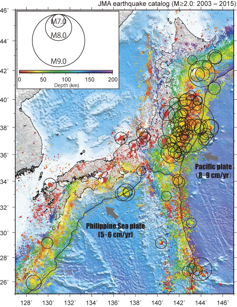
An earthquake represents the abrupt release of elastic energy accumulated within the Earth through relative displacement (slip), typically along a fault. The Japanese archipelago experiences frequent large earthquakes (Figs. 1 and 2), because the convergence of several oceanic and continental plates results in the rapid, widespread accumulation of elastic energy. Figure 1 shows the distribution of high-quality earthquake locations determined by the Japan Meteorological Agency (JMA) from 2003 to 2015, located using a dense network of seismic stations1) (e.g., Hi-net). The average number of annual earthquakes with Mj ≥ 2.0 (JMA magnitude) is ∼30,000, which ranks Japan among the world’s most seismically active countries. Many earthquake clusters are associated with large, shallow crustal earthquakes and/or huge earthquakes in subduction zones (Fig. 1). Earthquake activity in Northeast Japan has been reasonably intense during the past 13 years, primarily due to megathrust earthquakes along the subducting Pacific Plate, such as the 2011 Tohoku-Oki and 2003 Tokachi-Oki earthquakes. Similarly, Southwest Japan has experienced many megathrust earthquakes along the subducting Philippine Sea Plate (the recurrence interval ranges from 100 to 150 years), although recent seismicity appears less intense than in Northeast Japan, due to a gradual strain accumulation during interseismic period (stress build-up stage).
Figure 1.
Map of Mj ≥ 2.0 earthquakes in the Japanese archipelago from 2003 to 2015, using locations determined by the Japan Meteorological Agency (JMA). Large earthquakes (Mj ≥ 6.5) are plotted as circles scaled relative to their magnitudes. Other earthquakes are colored by depth. Gray arrows denote directions of convergence of the subducting Pacific Plate and the Philippine Sea Plate.
Figure 2.
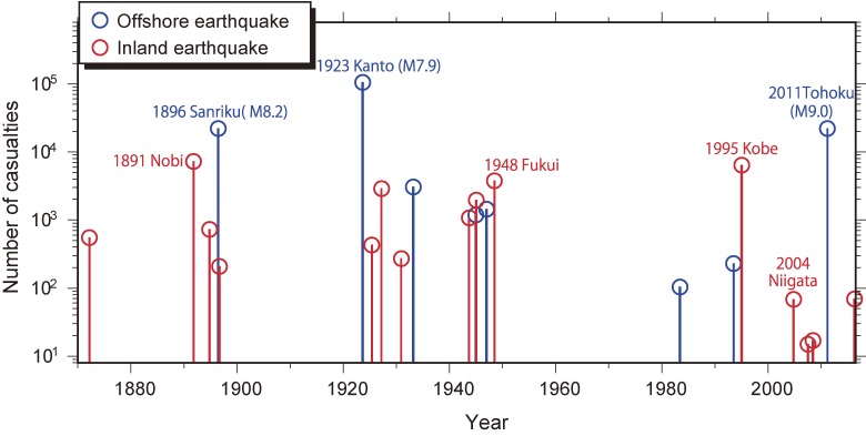
Time history of the number of casualties resulting from large earthquakes in Japan. Only earthquakes with ≥10 casualties are shown. Red and blue bars denote numbers of casualties resulting from inland and offshore earthquakes, respectively.
Shallow crustal earthquakes away from plate boundaries occur mainly as a result of the internal deformation of tectonic plates. Although the recurrence interval of each shallow crustal earthquake away from plate boundaries is longer than that of a megathrust earthquake, the resulting damage is often more devastating due to the proximity of areas vulnerable to strong ground motion. Examples of such damaging events include the 1891 Nobi earthquake (Mj 8.0), the 1948 Fukui earthquake (Mj 7.1), the 1995 Southern Hyogo Prefecture (Kobe) earthquake (Mj 7.3), and the 2004 mid-Niigata Prefecture earthquake (Mj 6.8). The average recurrence interval of shallow crustal earthquakes with significant casualties (defined as at least 50 missing or dead) is about 10 years, based on the JMA earthquake catalog and historical documents since 18722,3) (Fig. 2). One reason for the extensive damage caused by shallow crustal earthquakes is the existence of numerous active faults on the Japanese islands (>2,000), which result in frequent ruptures despite the longer recurrence intervals of individual events.
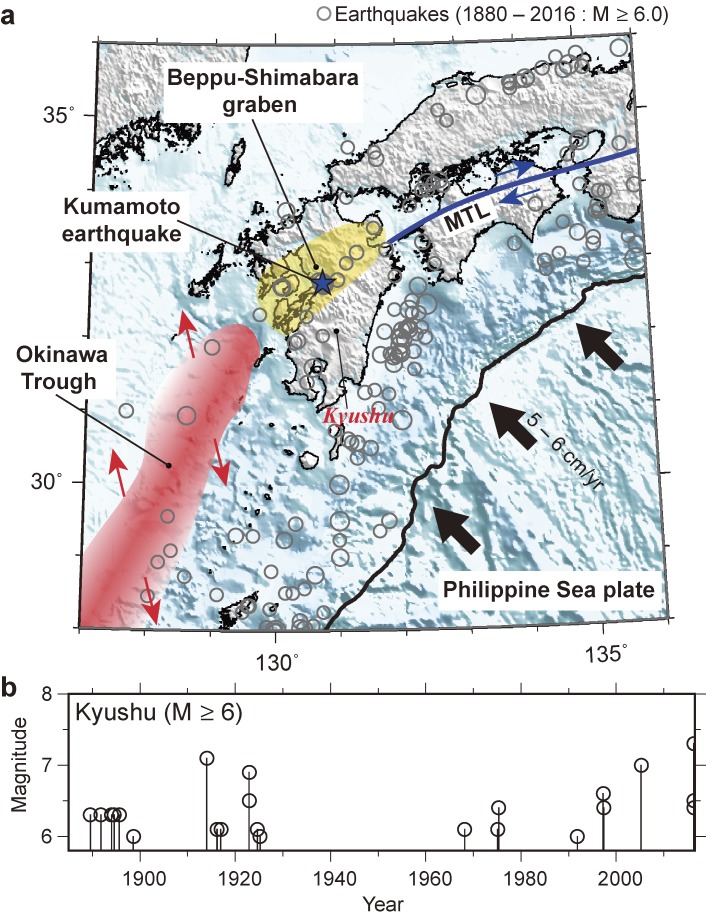
Beginning in April 2016, a series of powerful shallow earthquakes, including numerous aftershocks, struck the Kumamoto area of central Kyushu, Southwest Japan. After the first Mj 6.5 earthquake on 14 April 2016, a larger Mj 7.3 event occurred on 16 April 2016, about 28 hours after the first event, in an adjacent area (Figs. 3 and 4). Kyushu has a unique tectonic setting in that the central part of the island is subjected to N–S extensional stress, whereas shallow crust of the Japanese islands is mainly affected by compressive regional stress.4,5) Extensional deformation runs E–W across central Kyushu from Beppu to Unzen Volcano on the Shimabara Peninsula, resulting in the long-term development of extensive N–S graben structures with a well-developed normal fault system6,7) (Fig. 3). There are two accepted explanations for the driving force of this extensional deformation: northern extension of the opening Okinawa Trough,8,9) and transient variations in the convergence direction of the Philippine Sea Plate.10)
Figure 3.
Seismotectonic setting of Southwest Japan, including the Kyushu area. (a) Gray circles are epicenters of earthquakes shallower than 60 km with magnitudes of ≥6.0 from 1885 to 2016, scaled by magnitude. The blue star denotes the epicenter of the 2016 Kumamoto earthquake. Shaded yellow zone represents the Beppu–Shimabara graben structure. The blue line and shaded red zone represent the Median Tectonic Line (MTL) and Okinawa Trough, respectively. (b) Plot of magnitude as a function of time for earthquakes in Kyushu with magnitudes of ≥6.0.
Figure 4.
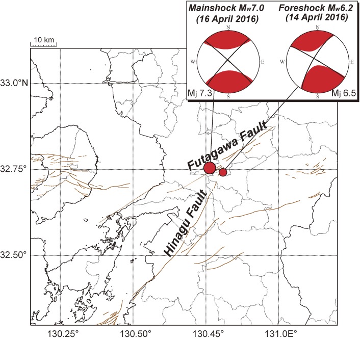
Enlarged map of the Kumamoto area. The nucleation points of the Mj 6.5 foreshock and the Mj 7.3 mainshock are shown as red circles. The CMT solution of each event is plotted using a lower-hemisphere projection. Red lines denote surface traces of active faults.
Recent geodetic measurements have revealed that a shear zone, showing right-lateral strike-slip faulting with high displacement rates of 7–8 mm/yr, is locally present along the southern edge of a graben, marking the boundary of a tectonic block.5,9,11) Within the graben, relatively large historical events (Mj ∼ 6) have been documented, including the 1889 Kumamoto earthquake12) (Fig. 3). In addition, small to moderate earthquakes, showing characteristics of both strike-slip and normal faulting, are frequently observed by seismic networks. These earthquakes form small clusters confined within the graben.5,13)
The seismicity of earthquake sequences is commonly categorized into foreshocks, mainshocks, and aftershocks, with assignments made a sufficient amount of time after a sequence has begun to enable an accurate assessment. It is too difficult to accurately determine the temporal position in an ongoing earthquake sequence,14) as each earthquake has a non-zero probability of being followed by a larger one, as described by the cascade model of seismicity.15–18) In the cascade model, a very small event can eventually connect to a larger one by a multiscale stress triggering process. Since the seismicity associated with the recent Kumamoto earthquake has decayed, we designate the Mj 6.5 earthquake of 14 April 2016 a foreshock, and the second large earthquake (Mj 7.3, 16 April 2016) the mainshock (Fig. 4).
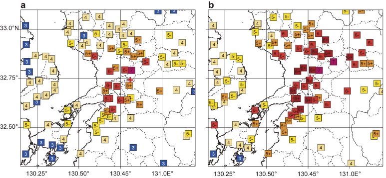
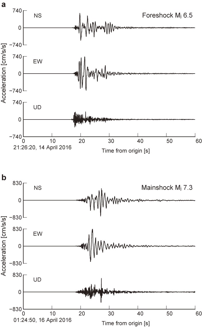
The Kumamoto earthquake sequence, including the strongest aftershocks, generated severe shaking that caused extensive destruction in central Kyushu. A comparison of the horizontal extent of strong shaking related to the foreshock and mainshock ruptures reveals that the mainshock rupture radiated higher-amplitude waveforms than the foreshock (Fig. 5). Due to the foreshock and mainshock ruptures, the town of Mashiki, in the Kumamoto area, was hit by shaking with the JMA seismic intensity scale of 7, twice in a short period of time (Fig. 5). The peak acceleration recorded by surface instruments at Mashiki exceeded 15 m/s2 (1,500 gal). Strong ground motions were recorded on horizontal component sensors with dominant periods of 1–2 s (Fig. 6), close to the natural frequency of wooden buildings, resulting in resonance oscillations that were partly responsible for severe damage to many structures. Strong ground motions with similar dominant periods were recorded during the Southern Hyogo Prefecture (Kobe) earthquake of 1995.19)
Figure 5.
Distributions of the JMA seismic intensity following (a) the Mj 6.5 foreshock rupture and (b) the Mj 7.3 mainshock rupture. Red crosses denote the nucleation points of the Mj 6.5 foreshock and the Mj 7.3 mainshock.
Figure 6.
Example of three-component strong motion data observed in Mashiki, Japan. Raw trace data (no filtering is made) are shown. (a) The Mj 6.5 foreshock. (b) The Mj 7.3 mainshock.
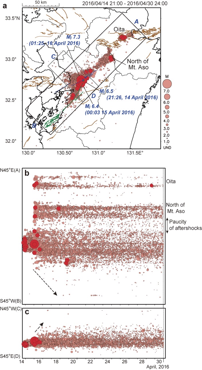
The intense seismicity of the earthquake sequence was aligned around a junction of the Hinagu and Futagawa faults, which are among the most active and high-risk faults in Japan (Figs. 4 and 7).20) In this article, we summarize seismicity related to the 2016 Kumamoto earthquake based on the spatio-temporal evolution of earthquakes and crustal surface deformation, recorded by a dense nationwide network of seismic1) (e.g., Hi-net) and geodetic (GEONET) sensors,21) including high-resolution surface deformation obtained from Synthetic Aperture Radar interferometry (InSAR).
Figure 7.
Seismicity sequence for the time period between 14 April 2016 and 30 April 2016. (a) Map view. Circles denote epicenters; red circles denote earthquakes with Mj ≥ 5.0. Red lines denote surface traces of active faults. (b) Space–time diagram of seismicity during the 2016 Kumamoto earthquake sequence (local time (JST, UTC +9)). Epicenters projected onto the N45E–S45W line (A–B) that approximates the fault strike direction are plotted against their occurrence time. The epicenters are located within a black rectangle in Fig. 7a. (c) Space–time diagram of epicenters projected onto the N45W–S45E line (C–D). The epicenters are located within a gray rectangle in Fig. 7a. Broken lines represent the approximate locations of the fronts of earthquake migrations after the mainshock rupture.
The Mj 6.5 foreshock of 14 April 2016
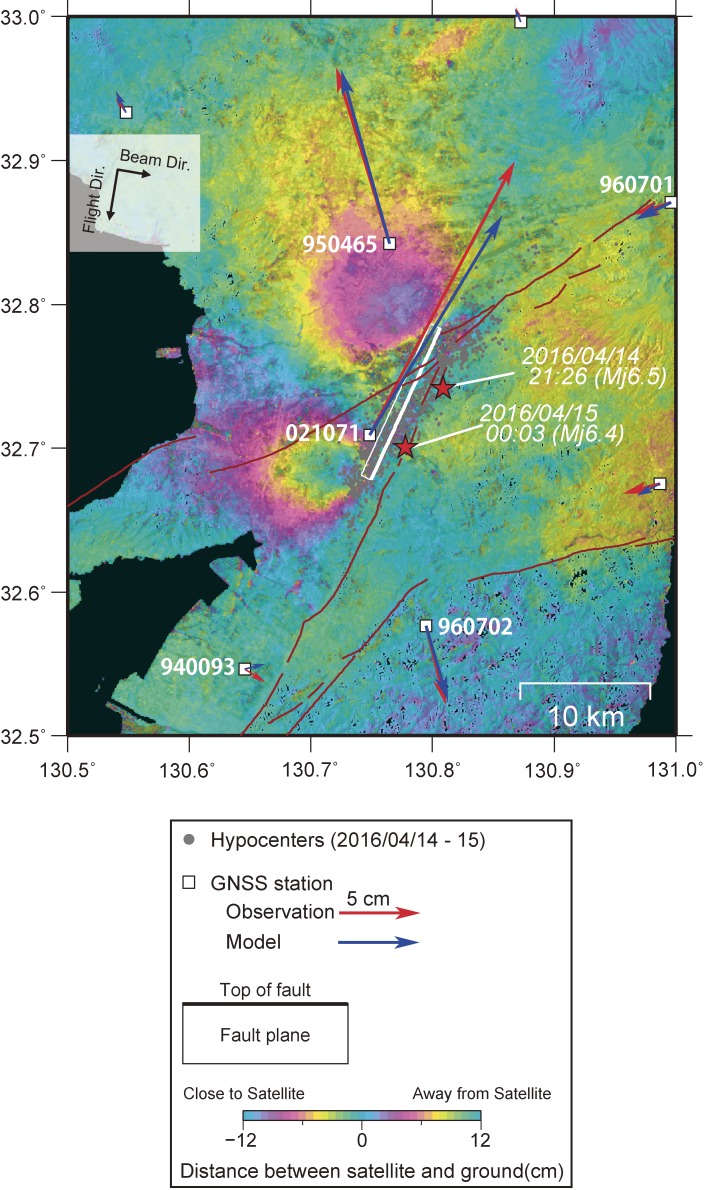
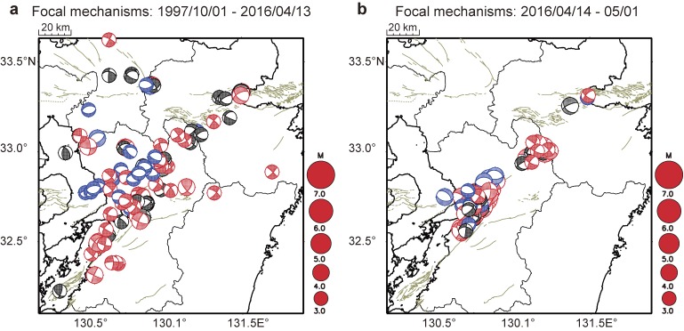
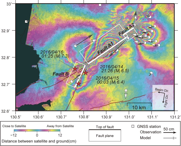
The Mj 6.5 foreshock occurred at 21:26:34 local time (JST, UTC +9), 14 April 2016. The depth of the rupture nucleation point of the foreshock was around 12 km. Aftershocks immediately following the foreshock were concentrated along the northernmost segment of the Hinagu Fault, with a fault strike length of ∼15 km (Figs. 7 and 8). After ∼3 hours (15 April 2016, 00:03:48 JST), an Mj 6.4 earthquake occurred at the southwestern extension of the Mj 6.5 foreshock area. Based on the aftershock distribution and the centroid moment tensor (CMT) solution (Mw 6.2), the faulting style of the foreshock was right-lateral strike slip (Fig. 4). The moment magnitude (Mw) estimated for the foreshock was 6.2. Geodetic measurements using GNSS and InSAR data provided a robust source model of the foreshock rupture, including the subsequent Mj 6.4 earthquake. The Mj 6.5 earthquake could be explained by right-lateral slip on a nearly vertical WNW-dipping fault, which is reasonably consistent with the CMT solution. The strike of the estimated source fault was nearly parallel to the surface trace of the Hinagu Fault. The amount of coseismic slip, fault length, and fault width (dip direction) were estimated from GNSS and InSAR data to be 1.1 m, 12.8 km, and 6.4 km, respectively (Table 1 and Fig. 8). The faulting style of the foreshock is a good match to both the regional deformation observed on geologic timescales and the regional stress field estimated from seismicity in the study area4,5) (Figs. 3 and 9).
Figure 8.
Source fault model of both the Mj 6.5 foreshock and the subsequent Mj 6.4 earthquake derived from GNSS data and InSAR analysis. White rectangle denotes the fault projected onto the surface. Thick white line indicates the top of the fault. Red and blue arrows at each GNSS station indicate horizontal surface displacements observed and predicted from the source model, respectively. Red stars are earthquake locations with Mj ≥ 6.0, and gray circles are the epicenters of events between 14 and 15 April 2016. Red lines represent active fault traces. Background image is coseismic deformation determined from the Advanced Land Observing Satellite 2 (ALOS-2) L-band data (analysis by GSI from the ALOS-2 raw data of JAXA). Interferogram is for the time period between 14 November 2014 and 15 April 2016, descending orbit.
Table 1.
Fault parameters for the foreshock and mainshock ruptures estimated by the geodetic measurements (Figs. 8 and 10)
Foreshock
| Longitude* | Latitude* | Depth of fault top (km)* | Length (km) | Width (km) | Strike (°) | Dip angle (°) | Rake (°) | Slp (m) | Mw** | |
|---|---|---|---|---|---|---|---|---|---|---|
| 130.806 | 32.784 | 1.4 | 12.8 | 6.4 | 205 | 83 | 173 | 1.1 | 6.23 |
Mainshock+Foreshock
| Longitude* | Latitude* | Depth of fault top (km)* | Length (km) | Width (km) | Strike (°) | Dip angle (°) | Rake (°) | Slp (m) | Mw** | |
|---|---|---|---|---|---|---|---|---|---|---|
| Fault A1 | 130.996 | 32.878 | 0.6 | 20.0 | 12.5 | 235 | 60 | 209 | 4.1 | 6.96 |
| Fault A2 | 130.975 | 32.883 | 0.2 | 5.1 | 6.6 | 56 | 62 | 178 | 3.8 | 6.36 |
| Fault B | 130.807 | 32.770 | 0.8 | 10.2 | 13.0 | 205 | 72 | 176 | 2.7 | 6.65 |
*Locations point to a left corner of an upper edge of a rectangular fault.
**Rigidity is assumed to be 34 GPa.
Figure 9.
Focal mechanisms in central Kyushu. (a) 1 January 1997 through 13 April 2016. (b) During the 2016 Kumamoto earthquake sequence. Each beach ball corresponds to a faulting style: red is strike-slip faulting, blue is normal faulting, and black is not categorized into either of these two faulting styles. Light green lines denote surface traces of active faults.
Immediately following the Mj 6.5 foreshock, the seismicity fronts of subsequent aftershocks migrated along the fault strike and dip, including propagation toward the mainshock nucleation point.22) Similar aftershock migration patterns were observed immediately after the 2004 Mw 6.0 Parkfield earthquake on the San Andreas Fault, the 2007 Mw 6.7 Noto Hanto earthquake in Japan, and the 2010 ML 6.4 Jiashian earthquake in Taiwan.23–25) These migration patterns are considered the result of propagation of aseismic slip transients (afterslip) around the large slip patch of each mainshock rupture.23–25) Because aseismic slip redistributes shear stress into the surrounding rock volume, the migration of aseismic slip effectively loaded the mainshock nucleation point, bringing the mainshock fault closer to failure. The propagation of aseismic slip thus appears to play a role in the buildup of shear stress on nearby fault segments, pushing them closer to failure.22,26,27)
The Mj 7.3 mainshock of 16 April 2016
While the seismicity rate following the foreshock gradually decayed with time, the Mj 7.3 mainshock took place near the foreshock area at 01:25:05 JST, 16 April 2016 (∼28 hours after the foreshock). Both the aftershock distribution and the CMT solution of the mainshock rupture (Mw 7.0) show right-lateral strike-slip (Fig. 4). As with the foreshock, the faulting style of the mainshock was highly consistent with inferred regional deformation patterns on geologic timescales, as well as the regional stress field of the study area (Figs. 3 and 9). The fault strike associated with the mainshock rupture is rotated by ∼12° NE with respect to the foreshock fault plane. The mainshock rupture nucleated around the northwestern tip of the foreshock area and propagated mainly along the active Futagawa Fault, as determined from an analysis of strong motion data.28)
Surface ruptures were clearly recognized, mainly along the Futagawa Fault and the northernmost segment of the Hinagu Fault; their total length reached ∼30 km (Kumahara et al., in preparation). Immediately after the Mj 7.3 mainshock, seismicity spread from the foreshock alignment (Fig. 7). In addition, the mainshock immediately triggered widespread seismicity along the northernmost section of the Hinagu Fault and the northeastern extension of the Futagawa Fault, including the north flank of Mount Aso volcano and the area around Oita (Fig. 7). After the mainshock rupture, the aftershock area gradually expanded to the southwest and northwest (broken lines in Fig. 7), a similar pattern to that which followed the Mj 6.5 foreshock rupture.22)
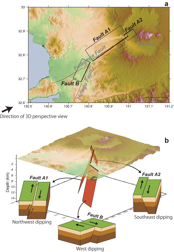
Geodetic measurements using GNSS and InSAR data revealed that the mainshock rupture occurred along multiple fault segments with different geometries (Fig. 10). At least three fault segments (A1, A2, and B in Figs. 10 and 11) are required to explain the surface deformation caused by the sequence (Table 1). Most of the elastic energy was released from the longest fault segment, designated A1 (length ∼ 20 km), which dips to the northwest at 60° (Figs. 10 and 11). The average slip along fault A1 was estimated at 4.1 m. The surface extension of A1 corresponds well to surface ruptures along the Futagawa Fault. An important finding of the geodetic inversion was that a significant normal slip component was required along this fault segment, comparable to the strike-slip component (Fig. 11). Due to this normal faulting movement, the northwestern side of the active fault trace subsided after the mainshock.
Figure 10.
Source fault model for the hosts of both the Mj 6.5 foreshock and the Mj 7.3 mainshock, derived from GNSS data and InSAR analysis. The three white rectangles denote fault planes projected onto the surface. A thick line indicates the top of each fault. Black and white arrows at each GNSS station indicate horizontal surface displacements observed and predicted from the source model, respectively. Red stars are earthquake locations with Mj ≥ 6.0. Background image is coseismic deformation determined from the ALOS-2 L-band data (analysis by GSI from the ALOS-2 raw data of JAXA). Interferogram is for the time period between 7 March 2016 and 18 April 2016, descending orbit.
Figure 11.
(a) Map view of the three source faults that hosted the Mj 6.5 foreshock and Mj 7.3 mainshock ruptures. (b) Three-dimensional perspective view of (a). Note that fault A2 is located within the caldera of Mount Aso.
Fault B, which shows dominantly right-lateral strike slip, is located along the northernmost segment of the Hinagu Fault, close to the host fault of the foreshock rupture (Figs. 8 and 10). However, the width of the mainshock fault plane extends much deeper than the foreshock rupture plane. In addition, the average slip amount along fault B is estimated to be ∼3 m, but we caution that the slip amount on this fault includes coseismic slip from both the Mj 6.5 foreshock and the subsequent Mj 6.4 earthquake with an estimated combined total of 1.1 m (Table 1 and Fig. 8). Although it is difficult to judge whether the same fault plane slipped twice during two different large events, we suppose that slightly different fault planes within the Hinagu Fault system could have slipped during each major earthquake rupture. To clarify this point, more detailed rupture modeling will be the subject of future work.
Fault A2, which shows dominantly right-lateral strike slip movement, is located within the caldera of Aso volcano. This fault dips to the southeast, opposite to the other faults (A1 and B); consequently, it may be a conjugate fault plane of A1. The average slip amount along fault A2 is estimated to be ∼3.8 m (Table 1). Due to dilatation associated with strike-slip faulting along faults A1 and A2, Mount Aso expanded volumetrically, mainly in the east–west direction (Figs. 10 and 11). Indeed, the summit of Mount Aso subsided by ∼20 cm after the mainshock rupture. It has been proposed that volumetric expansion induced by megathrust earthquakes at subduction zone volcanoes can be sometimes linked to eruptions.29) Volumetric expansion of a magma system often denotes an increase in magma overpressure due to volatile exsolution, bubble growth and mingling of different magmas etc., which can ultimately lead to new or more explosive eruptive activity.29) Therefore, it is important to maintain careful monitoring of Mount Aso with continuous seismic and geodetic observations in the future.
It is notable that there were few aftershocks at both the eastern edge of the fault A1 and the fault A2; i.e., at the eastern part of the mainshock rupture area (Figs. 7 and 10). There are two plausible explanations for the paucity of aftershocks. The first assumes a heterogeneous distribution of coseismic slip on the fault segments during the mainshock rupture. Numerous previous investigations worldwide have found evidence that aftershocks are quite rare in high slip regions; instead, they seem to occur mostly outside, or peripheral to, high slip zones.30–32) This is because a zone of high slip releases nearly all of its elastic energy, leaving little to trigger additional earthquakes. Alternately, it is possible that high temperatures in the caldera prevented the generation of aftershocks at both the eastern edge of the fault A1 and the fault A2. It is generally difficult for earthquakes to nucleate at temperatures of >300–350 ℃, due to enhanced slip stability in the brittle–ductile transition zone.33,34) Indeed, long-term seismic monitoring has suggested that the cutoff depth for shallow crustal earthquakes corresponds to an isotherm of ∼350 ℃.35,36) These observations support the idea that higher temperatures likely inhibit unstable dynamic slip along faults (i.e., earthquakes).
Intense aftershocks
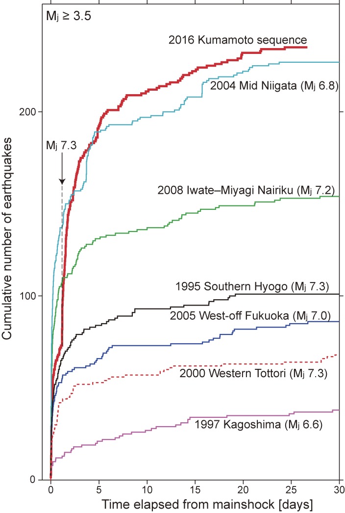
One striking feature of the Mj 6.5 foreshock was intense aftershock activity, including the Mj 6.4 earthquake only ∼3 hours after the foreshock rupture, in spite of the moderate foreshock magnitude. Figure 12 shows temporal changes in the cumulative number of aftershocks following each major earthquake at shallow crustal depths (Mj ≥ 3.5). Usually, there is a rough positive correlation between the mainshock magnitude and the number of aftershocks. However, the cumulative number of aftershocks was higher for the Mj 6.5 foreshock than for the 1995 Mj 7.3 Kobe earthquake, despite the vastly different seismic energies radiated by the two events (the latter was ∼16× larger than the former).
Figure 12.
Cumulative number of earthquakes after each major event in Japan as a function of elapsed time (Mj ≥ 3.5).
After the mainshock rupture, the total number of aftershocks again increased, and finally exceeded the number associated with the 2004 Mj 6.8 mid-Niigata Prefecture earthquake (Fig. 12). Based on aftershock alignments and crustal structure investigated by dense observations of aftershocks following the 2004 mid-Niigata Prefecture earthquake,37,38) it appears that many pre-existing faults are buried beneath the thick sedimentary basin of the Niigata region. Most of these faults formed as normal faults beneath a back-arc basin in a rift structure that developed during the opening of the Japan Sea (15–25 Ma). Parts of the normal faults have subsequently been reactivated as a reverse fault system, since the extensional tectonic stress regime changed to compressional in the late Pliocene (2–3 Ma) through a process of compressional inversion.39) Stress perturbations from the 2004 mid-Niigata Prefecture earthquake reactivated many faults within the rift system, resulting in intense aftershock activity. Analogously, our interpretation with respect to the Kumamoto sequence is that many aftershocks were caused by the simultaneous reactivation of pre-existing faults in the crust, which formed in association with development of the graben structure in central Kyushu (Fig. 3). Representative focal mechanisms of earthquakes from the Kumamoto sequence are similar to those observed before the event (Fig. 9); this observation also supports the hypothesis that the Kumamoto sequence reactivated numerous pre-existing faults in the shallow crust.
Dynamically triggered earthquake at Oita
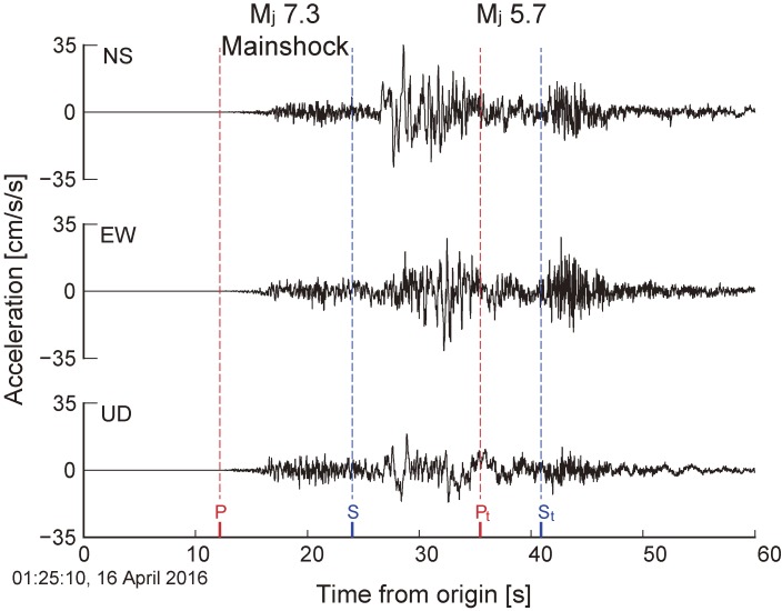
Reexamination of seismograms recorded in the Oita area reveals that an Mj 5.7 earthquake took place at 01:25:37 JST, 16 April 2016, during the passage of surface waves radiated by the mainshock. The delay with respect to the mainshock origin time was only 32 seconds. Seismograms recorded in the Oita area contained high-amplitude waveforms with dominant high-frequency components just after the mainshock S-wave arrival (Fig. 13). The relative richness of the high-frequency energy indicates an additional local earthquake occurred in the Oita area, far from the mainshock rupture. The simultaneous occurrence of an Mj 5.7 earthquake during wave propagation indicates that the second event was triggered by oscillatory “dynamic” deformation resulting from seismic waves radiated by the mainshock rupture.40,41) Dynamic triggering of earthquakes has been observed elsewhere on Earth: in particular, geothermal and volcanic regions are susceptible to local earthquake triggering by large, distant regional events.42) The most notable example yet recorded was an abrupt increase in moderate to large earthquakes (magnitudes 5.5–7.0) on a global scale immediately after the 2012 Mw 8.6 Off-Sumatra earthquake, due to the strong surface waves.43) In the Oita area, there are several geothermal plants, such as the Hachobaru Geothermal Power Plant. The local geothermal activity therefore indicates increased susceptibility to dynamic triggering of local earthquakes. A previous study suggested that the 2007 seismic swarm in the Oita region was linked to deep fluid circulation, based on temporal variations in seismic velocity close to the earthquake swarm.44) Fluid circulation increases fluid pressure and thereby reduces fault strength. Thus, it is inferred that fault strength in the Oita region is relatively weak due to active fluid circulation compared with the surrounding area. Such weakened faults are sensitive to external stress perturbations, and are more likely to slip during the passage of high-amplitude seismic waves. Similarly, low-frequency earthquakes and tectonic tremors in subduction zones18,45,46) are often excited by the passage of seismic waves from distant earthquakes.47,48) Investigations of deep seismic structure have suggested that high-pressure fluids near plate boundaries are involved in the generation of low-frequency earthquakes.46,49) Therefore, fault weakening by an increase in fluid pressure is a key factor in estimating the likelihood of dynamic triggering in a variety of tectonic environments.
Figure 13.
Example of seismic waveforms recorded in Usuki city, Oita Prefecture, Japan, during the passage of shear/surface waves from the Mj 7.3 mainshock rupture. Red and blue broken lines denote the arrival times of P- and S-waves, respectively, from the mainshock and from an Mj 5.7 earthquake dynamically triggered in the Oita region.
Postseismic deformation following the Mj 7.3 mainshock rupture
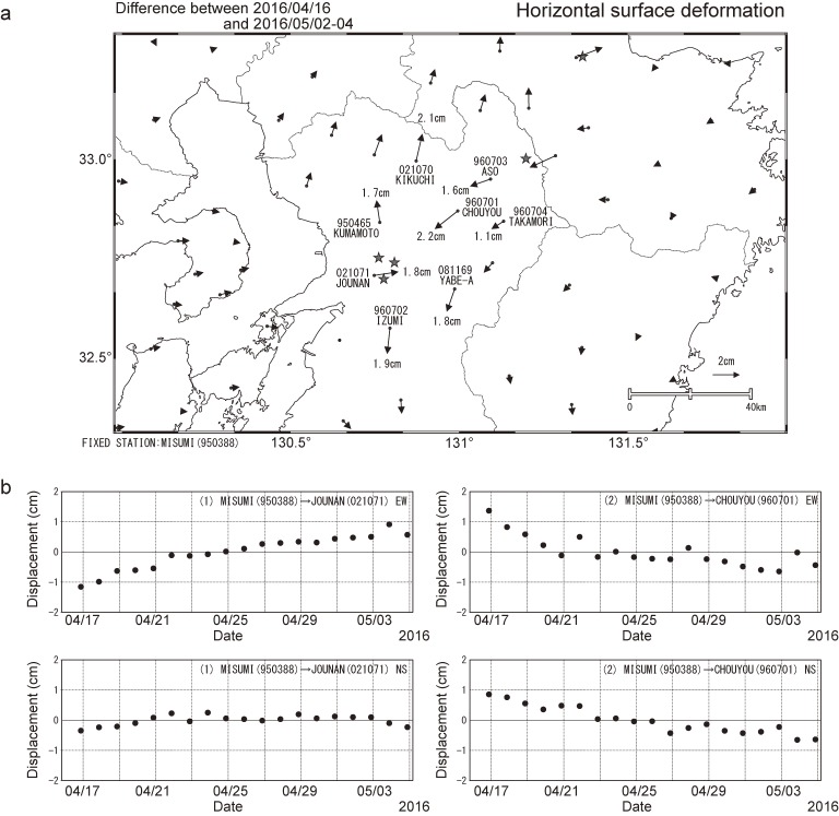
Following the mainshock rupture, postseismic surface deformation was identified using regional observations with the GNSS network. Postseismic deformation is often detected after large earthquakes in subduction zones and/or the shallow crust.50–56) The postseismic deformation following the Kumamoto earthquake is consistent with right-lateral strike motion (Fig. 14a), similar to that of the mainshock rupture. Postseismic surface displacement increased as a logarithmic function of time, and reached to be ∼2 cm at the largest station in about 3 weeks from the mainshock (Fig. 14b). This deformation could have been driven by two main factors: afterslip along the mainshock fault plane (around the large coseismic slip area), and viscoelastic flow in the mantle beneath the source region.54) Following the 2007 Noto-Hanto and 2008 Iwate Miyagi Nairiku earthquakes, afterslip was detected at shallower depths along the mainshock fault plane by studying temporal changes in GNSS data.51,52) In addition, GNSS data revealed that viscoelastic relaxation in the mantle caused by the 2008 Iwate Miyagi Nairiku earthquake continued for over 2 years.53) Such postseismic deformation driven by inland earthquake continues for more or less several years. In the subduction zone, after the 2011 Mw 9.0 Tohoku-Oki earthquake, significant ongoing surface deformation is still observed from the Tohoku region to the Kanto region, even though more than 5 years have passed.55,56)
Figure 14.
Postseismic surface deformation observed following the Mj 7.3 mainshock, 16 April 2016 to 3 May 2016. (a) Map of horizontal displacement. Star denotes an earthquake producing a coseismic step of surface displacement, which was corrected to obtain the postseismic deformation. (b) Time series of horizontal displacements recorded at two representative GNSS stations (Jounan and Chouyou in a).
Preliminary long-term estimates of earthquake probabilities
The northernmost segment of the Hinagu Fault system hosted the Mj 6.5 foreshock rupture. The faulting style was consistent with preliminary evaluations of active faults conducted by the Earthquake Research Committee of the Headquarters for Earthquake Research Promotion in the Ministry of Education, Culture, Sports, Science and Technology.20) However, the earthquake magnitude inferred from the evaluation was Mj 6.8, larger than the Mj 6.5 foreshock. The Earthquake Research Committee estimated an unknown probability of an Mj 6.8 earthquake within the next 30 years along the northernmost segment of the Hinagu Fault, due to the lack of long-term observations.
The Futagawa Fault radiated most of the seismic energy during the Mj 7.3 mainshock. The A1 fault has a similar geometry and length to preliminary estimates.20) The probability of an Mj 7.0 earthquake along the Futagawa Fault was estimated to be 0–0.9%; however, sequential fault ruptures along the Futagawa and Hinagu faults were not considered in this evaluation. Furthermore, fault A2 in Aso caldera was not considered, because its surface trace lies within the caldera and therefore could not be identified by previous investigations. Thus, to some extent, there is a lack of confidence in the preliminary evaluations of fault dimensions and magnitudes of future earthquakes.
The probability of an earthquake within the next 30 years on an active fault tends to be considerably lower than that of a megathrust earthquake in a subduction zone, because the recurrence interval of each active fault is usually at least 500–1,000 years. Sometimes, shallow crustal earthquakes occur along blind faults, which cannot be identified from surface investigations alone. Overlooking such faults leads to a systematic underestimation of earthquake probabilities. Furthermore, the density of pre-existing faults is high in the Japanese islands, for reasons discussed in detail above. To minimize these problems, the Earthquake Research Committee published the regional probabilities for an M ≥ 6.8 earthquake within the next 30 years for three separate regions of Kyushu (northern, central, and southern). Each regional probability was an integrated estimation of the probability of earthquake generation based on a combination of long-term activity on known active faults and recent seismicity within each region. By region, the regional probability estimates were 7%–13%, 18%–27%, and 7%–18% for northern, central, and southern Kyushu, respectively. Notably, the central and southern regions, where the 2016 Kumamoto earthquake sequence occurred, had relatively high regional probability in Kyushu.
Based on historic Kyushu earthquake records, magnitude 6 earthquakes tend to cluster temporally within several years of the first large earthquake (Fig. 3). During the 2016 Kumamoto earthquake sequence, both magnitude 6 and 7 earthquakes took place, with relatively short delay times between events. Hence, this observation underscores the importance of continuously monitoring seismicity and surface deformation in order to understand the interplay between large earthquakes. In the Japanese islands, most locations have a non-null probability of strong shaking due to a shallow crustal earthquake, due to both the large number of pre-existing faults (including blind faults) and the high rate of earthquake generation (Fig. 1). It is thus of crucial importance to protect our society against potential earthquake disasters by encouraging appropriate engineering and construction practices. Most casualties from shallow crustal earthquakes arise from the collapse of buildings and other constructions. Through well-designed, rigidly implemented, and strictly enforced building codes, the casualties from earthquakes can be minimized.14)
Acknowledgments
ALOS-2 data were provided by the Earthquake Working Group under a cooperative research contract with JAXA (Japan Aerospace Exploration Agency). All ALOS-2 data belong to JAXA. We would like to thank Handling Editor Y. Fukao and two anonymous reviewers for their constructive comments. The present work is supported by MEXT JSPS KAKENHI Grant Number JP16H06298. The GMT software package was used to generate some of the figures in this article.57)
References
- 1).Okada Y., Kasahara K., Hori S., Obara K., Sekiguchi S., Fujiwara H., Yamamoto A. (2004) Recent progress of seismic observation networks in Japan —Hi-net, F-net, K-NET and KiK-net—. Earth Planets Space 56, 15–28. [Google Scholar]
- 2).Utsu T. (1982) Catalog of large earthquakes in the region of Japan from 1885 through 1980. Bull. Earthq. Res. Inst. Univ. Tokyo 57, 401–463. [Google Scholar]
- 3).Koketsu, K. (2016) Epicenters of major damaging earthquakes in and around the Japanese islands. Chronological Scientific Table (ed. National Astronomical Observatory of Japan). Maruzen, Tokyo, P. 758 (in Japanese). [Google Scholar]
- 4).Terakawa T., Matsu’ura M. (2010) 3-D tectonic stress fields in and around Japan inverted from CMT data of seismic events. Tectonics 29, TC6008, doi:10.1029/2009TC002626. [Google Scholar]
- 5).Matsumoto S., Nakao S., Ohkura T., Miyazaki M., Shimizu H., Abe Y., Inoue H., Nakamoto M., Yoshikawa S., Yamashita Y. (2015) Spatial heterogeneities in tectonic stress in Kyushu, Japan and their relation to a major shear zone. Earth Planets Space 67, 172, doi:10.1186/s40623-015-0342-8. [Google Scholar]
- 6).Kamata H., Kodama K. (1999) Volcanic history and tectonics of the Southwest Japan Arc. Isl. Arc 8, 393–403, doi:10.1046/j.1440-1738.1999.00241.x. [Google Scholar]
- 7).Handa S. (2005) Electrical conductivity structures estimated by thin sheet inversion, with special attention to the Beppu-Shimabara graben in central Kyushu, Japan. Earth Planets Space 57, 605–612, doi:10.1186/BF03351839. [Google Scholar]
- 8).Nakahigashi K., Shinohara M., Suzuki S., Hino R., Shiobara H., Takenaka H., Nishino M., Sato T., Yoneshima S., Kanazawa T. (2004) Seismic structure of the crust and uppermost mantle in the incipient stage of back arc rifting — northernmost Okinawa Trough. Geophys. Res. Lett. 31, L02614, doi:10.1029/2003GL018928. [Google Scholar]
- 9).Wallace L.M., Ellis S., Miyao K., Miura S., Beavan J., Goto J. (2009) Enigmatic, highly active left-lateral shear zone in southwest Japan explained by aseismic ridge collision. Geology 37 (2), 143–146, doi:10.1130/G25221A.1. [Google Scholar]
- 10).Itoh Y., Kusumoto S., Takemura K. (2014) Evolutionary process of Beppu Bay in central Kyushu, Japan: a quantitative study of the basin-forming process controlled by plate convergence modes. Earth Planets Space 66, 74, doi:10.1186/1880-5981-66-74. [Google Scholar]
- 11).Nishimura S., Hashimoto M. (2006) A model with rigid rotations and slip deficits for the GPS-derived velocity field in southwest Japan. Tectonophysics 421, 187–207, doi:10.1016/j.tecto.2006.04.017. [Google Scholar]
- 12).Utsu, T. (1999) Seismicity Studies: a Comprehensive Review. University of Tokyo Press, Tokyo (in Japanese). [Google Scholar]
- 13).Saiga A., Matsumoto S., Uehira K., Matsushima T., Shimizu H. (2010) Velocity structure in the crust beneath the Kyushu area. Earth Planets Space 62, 449–462, doi:10.6047/eps.2010.02.003. [Google Scholar]
- 14).Shearer, P. (2009) Introduction to Seismology. Cambridge University Press, Cambridge UK. [Google Scholar]
- 15).Brune J.N. (1979) Implications of earthquake triggering and rupture propagation for earthquake prediction based on premonitory phenomena. J. Geophys. Res. 84, 2195–2198. [Google Scholar]
- 16).Fukao Y., Furumoto M. (1985) Hierarchy in earthquake distribution. Phys. Earth Planet. Inter. 37, 149–168. [Google Scholar]
- 17).Ide S., Aochi H. (2005) Earthquakes as multiscale dynamic ruptures with heterogeneous fracture surface energy. J. Geophys. Res. 110, B11303, doi:10.1029/2004JB003591. [Google Scholar]
- 18).Ide S. (2014) Modeling fast and slow earthquakes at various scales. Proc. Jpn. Acad. Ser. B 90, 259–277. [DOI] [PMC free article] [PubMed] [Google Scholar]
- 19).Furumura T., Koketsu K. (1998) Specific distribution of ground motion during the 1995 Kobe earthquake and its generation mechanism. Geophys. Res. Lett. 25, 785–788. [Google Scholar]
- 20).Headquarters for Earthquake Research Promotion (MEXT) (2016) List of long-term evaluation. http://www.jishin.go.jp/main/choukihyoka/ichiran.pdf.
- 21).Sagiya T. (2004) A decade of GEONET: 1994–2003 —The continuous GPS observation in Japan and its impact on earthquake studies—. Earth Planets Space 56, 29–41. [Google Scholar]
- 22).Kato A., Fukuda J., Nakagawa S., Obara K. (2016) Foreshock migration preceding the 2016 Mw 7.0 Kumamoto earthquake, Japan. Geophys. Res. Lett. 43, doi:10.1002/2016GL070079. [Google Scholar]
- 23).Peng Z., Zhao P. (2009) Migration of early aftershocks following the 2004 Parkfield earthquake. Nat. Geosci. 2, 877–881, doi:10.1038/ngeo697. [Google Scholar]
- 24).Kato A., Obara K. (2014) Step-like migration of early aftershocks following the 2007 Mw 6.7 Noto-Hanto earthquake, Japan. Geophys. Res. Lett. 41, 3864–3869, doi:10.1002/2014GL060427. [Google Scholar]
- 25).Tang C.-C., Lin C.-H., Peng Z. (2014) Spatial-temporal evolution of early aftershocks following the 2010 ML 6.4 Jiashian earthquake in southern Taiwan. Geophys. J. Int. 199 (3), 1772–1783, doi:10.1093/gji/ggu361. [Google Scholar]
- 26).Kato A., Obara K., Igarashi T., Tsuruoka H., Nakagawa S., Hirata N. (2012) Propagation of slow slip leading up to the 2011 Mw 9.0 Tohoku-Oki Earthquake. Science 335, 705–708, doi:10.1126/science.1215141. [DOI] [PubMed] [Google Scholar]
- 27).Kato A., Fukuda J., Kumazawa T., Nakagawa S. (2016) Accelerated nucleation of the 2014 Iquique, Chile Mw 8.2 Earthquake. Sci. Rep. 6, 24792, doi:10.1038/srep24792. [DOI] [PMC free article] [PubMed] [Google Scholar]
- 28).Okada Y. (2016) The 2016 Kumamoto earthquake (rapid report). Earthquake J. 61, 1–10. [Google Scholar]
- 29).Walter T.R., Amelung F. (2007) Volcanic eruptions following M ≥ 9 megathrust earthquakes: Implications for the Sumatra-Andaman volcanoes. Geology 35, 539–542. [Google Scholar]
- 30).Mendoza C., Hartzell S.H. (1988) Aftershock patterns and main shock faulting. Bull. Seismol. Soc. Am. 78 (4), 1438–1449. [Google Scholar]
- 31).Perfettini H., Avouac J.-P., Tavera H., Kositsky A., Nocquet J.-M., Bondoux F., Chlieh M., Sladen A., Audin L., Farber D.L., Soler P. (2010) Seismic and aseismic slip on the central Peru megathrust. Nature 465, 78–81, doi:10.1038/nature09062. [DOI] [PubMed] [Google Scholar]
- 32).Kato A., Igarashi T. (2012) Regional extent of the large coseismic slip zone of the 2011 Mw 9.0 Tohoku-Oki earthquake delineated by on-fault aftershocks. Geophys. Res. Lett. 39, L15301, doi:10.1029/2012GL052220. [Google Scholar]
- 33).Blanpied M.L., Lockner D.A., Byerlee J.D. (1995) Frictional slip of granite at hydrothermal conditions. J. Geophys. Res. 100, 13,045–13,064. [Google Scholar]
- 34).Kato A., Ohnaka M., Mochizuki H. (2003) Constitutive properties for the shear failure of intact granite in seismogenic environments. J. Geophys. Res. 108 (B1), 2060, doi:10.1029/2001JB00079. [Google Scholar]
- 35).Ito K. (1999) Seismogenic layer, reflective lower crust, surface heat flow and large inland earthquakes. Tectonophysics 306, 423–433. [Google Scholar]
- 36).Omuralieva A.M., Hasegawa A., Matsuzawa T., Nakajima J., Okada T. (2012) Lateral variation of the cutoff depth of shallow earthquakes beneath the Japan Islands and its implications for seismogenesis. Tectonophysics 518–521, 93–105. [Google Scholar]
- 37).Kato A., Sakai S., Hirata N., Kurashimo E., Iidaka T., Iwasaki T., Kanazawa T. (2006) Imaging the seismic structure and stress field in the source region of the 2004 mid-Niigata Prefecture earthquake: Structural zones of weakness and seismogenic stress concentration by ductile flow. J. Geophys. Res. 111, B08308, doi:10.1029/2005JB004016. [Google Scholar]
- 38).Kato A., Kurashimo E., Igarashi T., Sakai S., Iidaka T., Shinohara M., Kanazawa T., Yamada T., Hirata N., Iwasaki T. (2009) Reactivation of ancient rift systems triggers devastating intraplate earthquakes. Geophys. Res. Lett. 36, L05301, doi:10.1029/2008GL036450. [Google Scholar]
- 39).Williams G.D., Powell C.M., Cooper M.A. (1989) Geometry and kinematics of inversion tectonics. In Inversion Tectonics (eds. Cooper, M.A. and Williams, G.D.) Geol. Soc. Lond. Spec. Publ. 44, 3–15. [Google Scholar]
- 40).Gomberg J., Reasenberg P.A., Bodin P., Harris R.A. (2001) Earthquake triggering by seismic waves following the Landers and Hector Mine earthquakes. Nature 411, 462–466. [DOI] [PubMed] [Google Scholar]
- 41).Miyazawa M. (2011) Propagation of an earthquake triggering front from the 2011 Tohoku-Oki earthquake. Geophys. Res. Lett. 38, L23307, doi:10.1029/2011GL049795. [Google Scholar]
- 42).Stark M., Davis S. (1996) Remotely triggered microearthquakes at the Geysers Geothermal Field, California. Geophys. Res. Lett. 23 (9), 945–948, doi:10.1029/96GL00011. [Google Scholar]
- 43).Pollitz F., Stein R.S., Sevilgen V., Burgmann R. (2012) The 11 April 2012 east Indian Ocean earthquake triggered large aftershocks worldwide. Nature 490, 250–253, doi:10.1038/nature11504. [DOI] [PubMed] [Google Scholar]
- 44).Maeda T., Obara K., Yukutake Y. (2010) Seismic velocity decrease and recovery related to earthquake swarms in a geothermal area. Earth Planets Space 62, 685–691, doi:10.5047/eps.2010.08.006. [Google Scholar]
- 45).Obara K. (2002) Nonvolcanic deep tremor associated with subduction in southwest Japan. Science 296, 1679–1681, doi:10.1126/science.1070378. [DOI] [PubMed] [Google Scholar]
- 46).Shelly D.R., Beroza G.C., Ide S. (2006) Low-frequency earthquakes in Shikoku, Japan, and their relationship to episodic tremor and slip. Nature 442, 188–191, doi:10.1038/nature04931. [DOI] [PubMed] [Google Scholar]
- 47).Miyazawa M., Mori J. (2005) Detection of triggered deep low-frequency events from the 2003 Tokachi-oki earthquake. Geophys. Res. Lett. 32, L10307, doi:10.1029/2005GL022539. [Google Scholar]
- 48).Aiken C., Peng Z. (2014) Dynamic triggering of microearthquakes in three geothermal/volcanic regions of California. J. Geophys. Res. Solid Earth 119, 6992–7009, doi:10.1002/2014JB011218. [Google Scholar]
- 49).Kato A., Iidaka T., Ikuta R., Yoshida Y., Katsumata K., Iwasaki T., Sakai S., Thurber C., Tsumura N., Yamaoka K., Watanabe T., Kunitomo T., Yamazaki F., Okubo M., Suzuki S., Hirata N. (2010) Variations of fluid pressure within the subducting oceanic crust and slow earthquakes. Geophys. Res. Lett. 37, L14310, doi:10.1029/2010GL043723. [Google Scholar]
- 50).Heki K., Miyazaki S., Tsuji H. (1997) Silent fault slip following an interpolate thrust earthquake at the Japan Trench. Nature 386, 595–598. [Google Scholar]
- 51).Iinuma T., Ohzono M., Ohta Y., Miura S., Kasahara M., Takahashi H., Sagiya T., Matsushima T., Nakao S., Ueki S., Tachibana K., Sato T., Tsushima H., Takatsuka K., Yamaguchi T., Ichiyanagi M., Takada M., Ozawa K., Fukuda M., Asahi Y., Nakamoto M., Yamashita Y., Umino N. (2009) Aseismic slow slip on an inland active fault triggered by a nearby shallow event, the 2008 Iwate-Miyagi Nairiku earthquake (Mw6.8). Geophys. Res. Lett. 36, L20308, doi:10.1029/2009GL040063. [Google Scholar]
- 52).Hashimoto M., Takahashi H., Doke R., Kasahara M., Takeuchi A., Onoue K., Hoso Y., Fukushima Y., Nakamura K., Ohya F., Honda R., Ichiyanagi M., Yamaguchi T., Maeda T., Hiramatsu Y. (2008) Postseismic displacements following the 2007 Noto peninsula earthquake detected by dense GPS observation. Earth Planets Space 60, 139–144. [Google Scholar]
- 53).Ohzono M., Ohta Y., Iinuma T., Miura S., Muto J. (2012) Geodetic evidence of viscoelastic relaxation after the 2008 Iwate-Miyagi Nairiku earthquake. Earth Planets Space 64 (9), 759–764, doi:10.5047/eps.2012.04.001. [Google Scholar]
- 54).Wang K., Hu Y., He J. (2012) Deformation cycles of subduction earthquakes in a viscoelastic Earth. Nature 484, 327–332, doi:10.1038/nature11032. [DOI] [PubMed] [Google Scholar]
- 55).Watanabe S., Sato M., Fujita M., Ishikawa T., Yokota Y., Ujihara N., Asada A. (2014) Evidence of viscoelastic deformation following the 2011 Tohoku-Oki earthquake revealed from seafloor geodetic observation. Geophys. Res. Lett. 41, doi:10.1002/2014GL061134. [Google Scholar]
- 56).Sun T., Wang K., Iinuma T., Hino R., He J., Fujimoto H., Kido M., Osada Y., Miura S., Ohta Y., Hu Y. (2014) Prevalence of viscoelastic relaxation after the 2011 Tohoku-oki earthquake. Nature 514, 84–87, doi:10.1038/nature13778. [DOI] [PubMed] [Google Scholar]
- 57).Wessel P., Smith W.H.F. (1998) New, improved version of the generic mapping tools released. Eos Trans. AGU 79 (47), 579, doi:10.1029/98EO00426. [Google Scholar]


