Abstract
Knowing where, when, and how much rice is planted and harvested is crucial information for understanding the effects of policy, trade, and global and technological change on food security. We developed RiceAtlas, a spatial database on the seasonal distribution of the world’s rice production. It consists of data on rice planting and harvesting dates by growing season and estimates of monthly production for all rice-producing countries. Sources used for planting and harvesting dates include global and regional databases, national publications, online reports, and expert knowledge. Monthly production data were estimated based on annual or seasonal production statistics, and planting and harvesting dates. RiceAtlas has 2,725 spatial units. Compared with available global crop calendars, RiceAtlas is nearly ten times more spatially detailed and has nearly seven times more spatial units, with at least two seasons of calendar data, making RiceAtlas the most comprehensive and detailed spatial database on rice calendar and production.
Subject terms: Agriculture, Geography
Background & Summary
Rice is the world’s most important food crop. It is harvested from over 163 million ha in more than 100 countries (http://www.fao.org/faostat/en/#home). It is grown in diverse cropping systems and environments—from single crop systems in temperate and tropical regions in both rainfed and irrigated conditions, to intensive monoculture in irrigated areas in the tropics where rice is grown two or three times per year.
Although information on the distribution of global rice production by region and country can be derived from readily available statistics (e.g., http://www.fao.org/faostat/en/#home, http://apps.fas.usda.gov/psdonline/), information on its distribution within a year is often lacking. Rice area and production statistics are available only at the national level for some countries; if these are available at the subnational level, the statistics are often by year and not by season. Linking information on production and area to the crop calendar can help analyze spatio-temporal variation in rice production. This can contribute to an improved ability to answer questions about food security. For example, this information, together with data on climate shocks and rice stocks, can be used to better assess seasonal and geographic variation in rice supply to mitigate shortfalls in rice availability at certain times of the year. Furthermore, information on where and when rice is planted is needed to quantify the potential risk of abiotic and biotic stresses during the rice-growing seasons, and to model the effects of global climate change and technological change on rice yield and production. In summary, a globally complete and spatially explicit rice crop calendar linked to area and production estimates is a valuable global public good.
Several rice crop calendars exist (http://www.fao.org/agriculture/seed/cropcalendar/welcome.do, 1,2,3). Some are limited to a few countries or have regional coverage, whereas others are global. Regional resources include crop calendars for Latin America and the Caribbean1 and for Africa (http://www.fao.org/agriculture/seed/cropcalendar/welcome.do), which have information on the planting and harvesting periods of rice and other major crops by agro-ecological zone. The database on rice for Africa includes 26 countries, and that for Latin America includes 24. The calendar for Latin America is outdated, whereas that for Africa does not include many rice-producing countries. Global calendars have been developed recently2,3. The calendars by Sacks et al.2 lack detail at the subnational level, especially in developing countries. The MIRCA2000 (ref. 3) calendar is monthly, gridded, and available for irrigated and rainfed rice, but does not adequately cover rice areas that are cultivated more than once a year. In both global calendars, some areas with rice grown in two seasons have data for only one season. Also, they include only a maximum of two seasons—the main and second season—inadequately covering some of the world’s most important rice areas with three distinct cropping seasons, such as in Bangladesh, where aman rice (main rainy season) is harvested in November-December; boro (dry season) in April-May; and aus in July-August. Parts of Vietnam also have three cropping seasons—winter-spring, spring-summer, and summer-autumn—and this is also the case in parts of China (early and late seasons for double-cropped rice areas; and middle for single-cropped rice areas) and India.
Because of the need to develop a spatially explicit global database of rice calendars that includes detailed information on rice areas with more than one rice crop in a year, we compiled the most detailed available datasets of rice planting and harvesting dates by growing season in all rice-producing countries, and linked the database to subnational production data. ‘RiceAtlas’ provides a spatial and seasonal distribution of the world’s rice production. RiceAtlas contributes to the GEOGLAM (Group on Earth Observations Global Agricultural Monitoring)4 initiative and regional partnerships, such as the Asian Rice Crop Estimation and Monitoring initiative (Asia-RiCE), by providing information for agricultural monitoring requirements, satellite data acquisition plans, and global crop outlook.
Methods
Rice calendar
The rice calendar in RiceAtlas is based on various published sources such as global and regional datasets, international and national publications, online sources, and unpublished data sources such as expert knowledge. Collaborators from various countries contributed new datasets, which were used to revise or validate the initial database that was compiled from existing sources (Table 1, Supplementary Table 1).
Table 1. Main data sources for rice-growing regions*.
| Region | Calendar | Production |
|---|---|---|
| Asia | Various national sourcesIndia: Gumma et al.7; Rice Knowledge Management Portal (2011); National Food Security Mission, Government of IndiaChina: Van Wart et al.8 | CountrySTAT† FAOSTAT‡, Various national sourcesIndia: DACNET; Department of Agriculture and Extension of the respective states or from Ministry of Agriculture, IndiaChina: China Agricultural Yearbook (various issues, 2009-2011) |
| Africa | Experts from AfricaRice and its partners, FAO§ | CountrySTAT†, FAOSTAT‡Nigeria: CountrySTAT†Madagascar: FAOSTAT‡ |
| Latin America and Caribbean | FAO1Brazil: Maclean et al.9; IBGE, Brazil Rice | FAOSTAT‡ |
| Europe | Various sources | FAOSTAT‡ |
| Rest of the world | Various sources | FAOSTAT‡ |
We collected data on the start, peak, and end dates of sowing or transplanting, and the start, peak, and end dates of harvesting of rice for all seasons in all rice-growing countries. In cases where peak planting and harvesting dates were not available, we estimated those to be at the midpoint between the start and end dates. If only the peak planting dates were available, we assumed the start and end dates of planting to be 15 days before and 15 days after the peak date, respectively. The same procedure was used to estimate the start and end dates of harvesting if only peak harvesting dates were available. Planting in a region is not done on a single date but the length of the planting window varies between regions. In the absence of information, we set the planting window to 30 days. This can be revised when better information becomes available. Where available, additional data such as crop establishment method and seedling age for transplanted rice were recorded.
To describe RiceAtlas and compare its calendar with existing regional (http://www.fao.org/agriculture/seed/cropcalendar/welcome.do; ref 1) and global (Sacks et al.2 and MIRCA20003) datasets, we used the following metrics:
Coverage. This refers to the number of rice growing countries with data.
Spatial detail. This refers to the number of spatial units for which data is available. To avoid double counting, we merged adjacent spatial units that have the same calendar. In the case of MIRCA2000, rice calendars are available for irrigated and rainfed rice. If both were available for one spatial unit, only the irrigated calendar was considered in the count of the spatial units.
Seasonal detail. This is the number of spatial units with calendars for two or more seasons. This is a metric for the temporal completeness of the crop calendar.
Resolution. We used measures similar to those used by Deichmann5:
Overall spatial resolution
Rice area resolution
Rice production
We compiled rice production and area (henceforth referred to as production data or production statistics) from various sources such as national statistics agencies, agriculture departments, and the FAO (http://www.fao.org/faostat/en/#home, http://www.fao.org/economic/ess/countrystat/en/; Table 1, Supplementary Table 1). Because available rice production data from different countries do not refer to the same years, we used the average of the last three years of available data, and adjusted these, such that the national production totals match the 2010–2012 average production from FAO (http://www.fao.org/faostat/en/#home). A three-year average retains the recent production level and accounts for interannual fluctuations in production.
Spatial and seasonal analysis of rice production
Rice production data were linked with the crop calendar data through their locations using administrative boundaries in the GADM database of the Global Administrative Areas (version 2.8; http://www.gadm.org). There were two cases where the compiled data needed adjustment:
Different levels of spatial resolution. For example, production statistics were available at one level (e.g., first level subdivisions) and the crop calendar was available at the a more detailed level (e.g., second level subdivisions) (35 countries);
Mismatch in seasonal information, for example, the crop calendar reported double cropping, but the production data referred to only a single cropping season (33 countries).
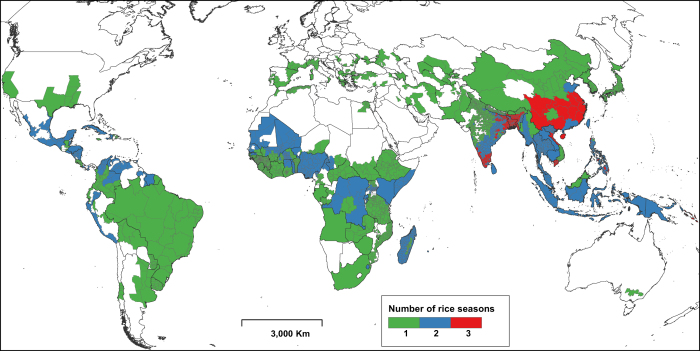
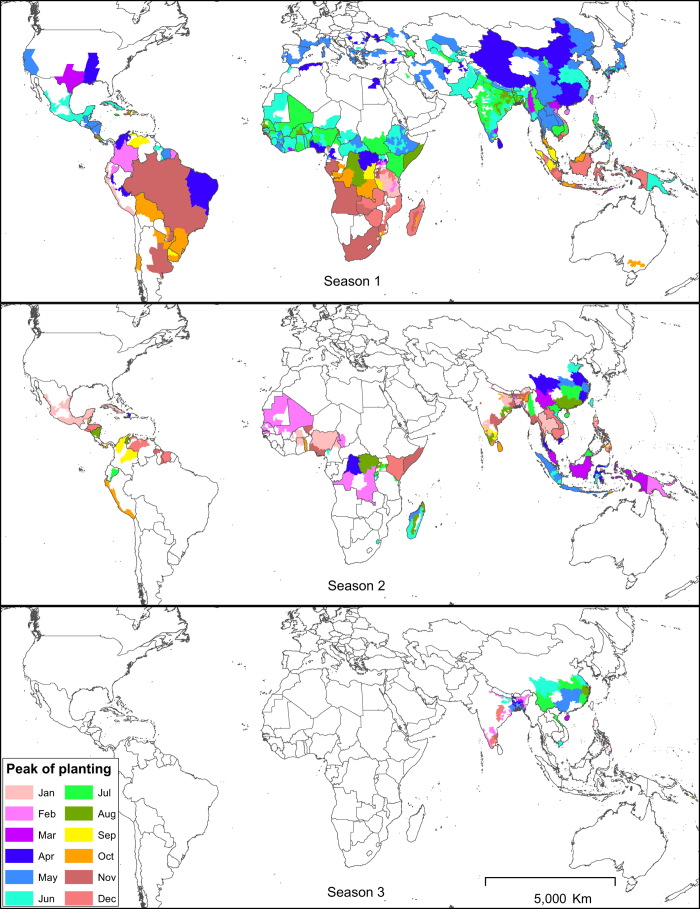
In cases where the calendar data were spatially more detailed than the production data, we disaggregated the latter using expert knowledge where available, or by assuming equal production over the entire area or season. Conversely, if production data were more detailed than the calendar data, we disaggregated the latter and assumed the same calendar for all disaggregated spatial units. If the production statistics explicitly referred to only a single cropping season but the rice calendar had more than one season, rice production was attributed to the main season only. Because of the differences in the level of detail of available data for both rice calendar and production, the spatial detail of RiceAtlas varies across continents and countries (Figures 1 and 2, Table 2).
Figure 1. Spatial units covered in RiceAtlas and the number of rice-growing seasons.
Figure 2. Peak rice planting months by season.
Season 1 refers to the main rice-growing season, that is, the season with the highest rice production. Season 2 has the second highest rice production and Season 3 the least.
Table 2. Level of detail of RiceAtlas by geographic region.
| Region |
No. of countries |
No. of spatial units * | Overall spatial resolution (000 km) | Rice area per spatial unit (000 ha) | ||
|---|---|---|---|---|---|---|
| All | With subnational data | With two or more seasons | ||||
|
Rice calendar |
||||||
| Asia | 31 | 17 | 15 | 1,121 | 5 | 129 |
| Africa | 42 | 25 | 20 | 966 | 5 | 11 |
| Latin America and the Caribbean | 26 | 11 | 15 | 87 | 15 | 66 |
| Europe | 11 | 4 | 0 | 24 | 28 | 30 |
| Rest of the world | 5 | 1 | 2 | 11 | 40 | 116 |
| Total | 115 | 58 | 52 | 2,209 | 7 | 74 |
|
Rice production |
||||||
| Asia | 31 | 17 | 15 | 1,183 | 5 | 122 |
| Africa | 42 | 35 | 20 | 609 | 7 | 17 |
| Latin America and the Caribbean | 26 | 21 | 15 | 316 | 8 | 18 |
| Europe | 11 | 7 | 0 | 36 | 23 | 20 |
| Rest of the world | 5 | 1 | 1 | 28 | 25 | 45 |
| Total | 115 | 77 | 51 | 2,172 | 7 | 75 |
*Adjacent spatial units with the same calendar were merged and the values here refer to the number of remaining units.
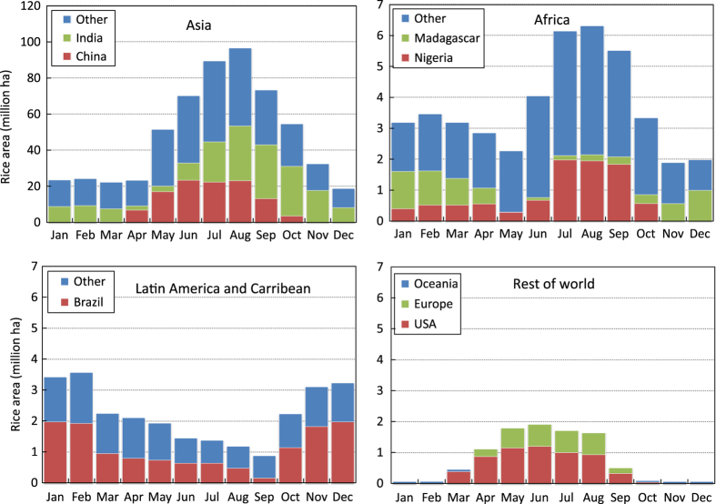
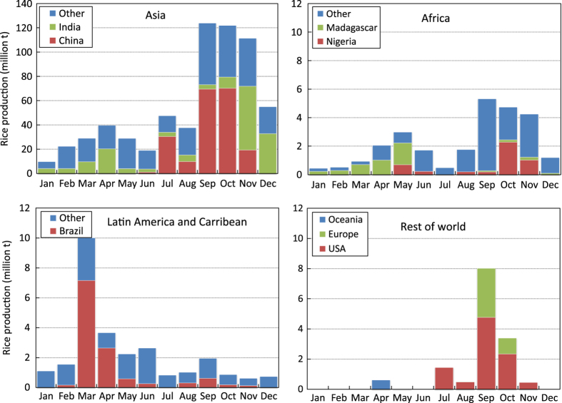
The production data were distributed proportionally to the corresponding months based on sowing or transplanting, and harvesting dates (start, peak, and end) per season, with the peak planting or harvesting months having greater weight and progressively lesser weights for months away from the peak. For example, if the planting window was three months and the peak planting was the middle month, the first and last months were given equal weights of 0.25 each whereas the peak planting month was given 0.5. If production data for a region was available annually but there were two or more known crop seasons in a year in that area, production data were first disaggregated by season (equally, if seasonal data were not available) then distributed to months based on months of harvest. Area data, on the other hand, were distributed based on the months of both planting and harvesting to estimate the monthly area with a standing rice crop. Global monthly rice-growing areas, as well as regional and within-year distribution of rice production at harvest time, show the production peak and lean periods by region (Figures 3 and 4).
Figure 3. Monthly rice crop area in different geographic regions, 2010-2012.
Figure 4. Rice production by geographic region and month of harvest, 2010-2012.
Code availability
R code used to compute for the total planted area or production by month for each country is available from Data Citation 1.
Data Records
RiceAtlas is a spatial database of rice calendars and production in 115 countries, with its attributes given in Table 3. RiceAtlas version 1.0 can be downloaded from the IRRI Dataverse Repository (Data Citation 1).
Table 3. Attributes of RiceAtlas.
| Attribute name | Unit | Description |
|---|---|---|
|
Location information |
||
| CONTINENT | Continent | |
| ISO | ISO three-letter country code (alpha-3) | |
| COUNTRY | Country name | |
| REGION | Subnational unit: This can be state, province, or district, depending on country | |
| SUBREGION | Subnational unit lower than region | |
| HASC | Hierarchical administrative subdivision codes (HASC) represent names of country subdivisions, such as states, province, and regions | |
|
Crop calendar |
||
| NAME* | Name of the season | |
| NUM_CROP | Number of distinct rice crop seasons in a year | |
| PLANT_ST* | Day-of-year | Onset of planting period |
| PLANT_PK* | Day-of-year | Peak planting date |
| PLANT_END* | Day-of-year | End of planting period |
| HARV_ST* | Day-of-year | Onset of harvest period |
| HARV_PK* | Day-of-year | Peak harvest date |
| HARV_END* | Day-of-year | End of harvest period |
| MATURITY* | Number of days | Growing period of rice from sowing to harvesting |
| MATURITYS* | Number of days | Onset of maturity duration range |
| MATURITYE* | Number of days | End of maturity duration range |
| SEED_AGE* | Number of days | Age of rice seedlings at the time of transplanting; 0 for direct seeded; −1 for no data |
| METHOD | Dominant planting method (direct-seeded, transplanted) for all seasons | |
|
Production |
||
| A_TOTAL | ha | Total rice area |
| A_S* | ha | Area by season |
| A_Jan, A_Feb, A_Mar, A_Apr, A_May, A_Jun, A_Jul, A_Aug, A_Sep, A_Oct, A_Nov, A_Dec | ha | Rice area by month |
| P_TOTAL | t | Total rice production |
| P_S* | t | Rice production by season |
| P_Jan, P_Feb, P_Mar, P_Apr, P_May, P_Jun, P_Jul, P_Aug, P_Sep, P_Oct, P_Nov, P_Dec | t | Rice production by month |
*The actual attribute names have suffixes: 1 refers to the main season, 2 for second season, and 3 for third season, e.g., PLANT_ST1, PLANT_ST2, PLANT_ST3.
RiceAtlas will be improved by including more detailed data for selected countries when these become available and accessible. New versions will be periodically uploaded to the Repository.
Technical Validation
Expert knowledge was used to validate and correct the crop calendars. More than 50 persons contributed data and/or validated the crop calendars. Digital and analogue country-level maps and tabulations were provided to rice experts to verify the data for countries they were familiar with. Maps and tables were provided to members of the Temperate Rice Research Consortium during their review and planning meeting at IRRI headquarters on 8−9 November 2013. The data from Africa were reviewed by 27 rice scientists during the AfricaRice Science Week on 9−13 February 2015 in Cotonou, Benin. Their comments were addressed and their revisions were included in the current version. All authors validated the crop calendars for their respective regions of expertise.
RiceAtlas v1.0 has 2,725 spatial units in total. It has 2,209 unique contiguous spatial units for the rice calendar and is nearly 10 times more spatially detailed than previously published global rice calendars (Table 4). It has 904 spatial units with data for at least two rice growing seasons. This is almost seven times more than those of published global rice calendars and nearly 10 times more for Asia. RiceAtlas, therefore, greatly improves coverage of intensively cultivated rice areas in the region. In addition, based on comparison among rice calendars in terms of overall spatial resolution and rice area resolution, RiceAtlas is the most comprehensive and detailed global rice calendar currently available.
Table 4. Level of detail of RiceAtlas and selected global or regional rice calendars.
| Metric/geographic region | RiceAtlas | FAO* | Sacks et al.2 | MIRCA20003 |
|---|---|---|---|---|
| Countries covered (number) |
||||
| Asia | 31 | _ | 22 | 31 |
| Africa | 42 | 26 | 30 | 42 |
| Latin America and the Caribbean | 26 | 24 | 23 | 26 |
| Europe | 11 | _ | 3 | 11 |
| Rest of the world | 5 | _ | 2 | 5 |
| World | 115 | _ | 80 | 115 |
| Spatial units (number)† |
||||
| Asia | 1,121 | _ | 89 | 94 |
| Africa | 966 | 113 | 33 | 42 |
| Latin America and the Caribbean | 87 | 45 | 24 | 65 |
| Europe | 24 | _ | 3 | 11 |
| Rest of the world | 11 | _ | 8 | 16 |
| World | 2,209 | _ | 157 | 228 |
| Number of spatial units with at least two seasons |
||||
| Asia | 630 | _ | 27 | 64 |
| Africa | 239 | 117 | 3 | 27 |
| Latin America | 33 | 39 | 5 | 43 |
| Europe | 0 | _ | 0 | 0 |
| Rest of the world | 2 | _ | 0 | 3 |
| World | 904 | _ | 35 | 137 |
| Average resolution (000 km) |
||||
| Asia | 5 | _ | 16 | 17 |
| Africa | 5 | 13 | 24 | 25 |
| Latin America | 15 | 21 | 29 | 18 |
| Europe | 28 | _ | 17 | 42 |
| Rest of the world | 40 | _ | 46 | 33 |
| World | 7 | _ | 23 | 22 |
| Average rice area per spatial unit (000 ha) |
||||
| Asia | 129 | _ | 1,609 | 1,537 |
| Africa | 11 | 93 | 307 | 252 |
| Latin America and the Caribbean | 66 | 127 | 238 | 88 |
| Europe | 30 | _ | 124 | 65 |
| Rest of the world | 116 | _ | 221 | 80 |
| World | 74 | _ | 1,027 | 714 |
†Calendars were dissolved and the values here refer to the number of contiguous spatial units with unique crop calendars.
RiceAtlas will be updated as more detailed data become available and accessible. To date, the effort has concentrated on collecting and validating data for Asia and Africa. Arrangements have been made to update data for Latin America through the International Center for Tropical Agriculture (CIAT) and its network of partners in the region.
The spatial detail of RiceAtlas varies across continents and countries, and for some applications a higher spatial resolution could be desirable. To create a more homogenous and higher spatial resolution database, the available data could be used to build predictive models to downscale the rice calendar data to a higher spatial resolution (e.g., 1 km2 grid cells). Such models could use climate data and satellite images. For example, Moderate Resolution Imaging Spectroradiometer (MODIS) images have been used to detect key phenological stages of the rice crop including start of season6. The use of time series of satellite images can also allow for the detection of annual variation, changes in cropping intensity and shifts in planting dates.
Additional Information
How to cite this article: Laborte, A. G. et al. RiceAtlas, a spatial database of global rice calendars and production. Sci. Data 4:170074 doi: 10.1038/sdata.2017.74 (2017).
Publisher’s note: Springer Nature remains neutral with regard to jurisdictional claims in published maps and institutional affiliations.
Supplementary Material
Acknowledgments
This work was supported by the CGIAR Global Rice Science Partnership (GRiSP) and Policies, Institutions, and Markets (PIM), and the Global Futures Project.
We thank the following people who contributed datasets and/or checked and validated data:
Asia:
Neemi Beser, Parvesh Kumar Chandna, Muralli Krishna Gumma, Nyo Me Htwe, David Johnson, Inez Slamet-Loedin, David Raitzer, Ben Samson, and Dule Zhao
Africa:
Komlan Adigninou Ablede, Cyriaque Akakpo, Moundibaye Dastre Allarangaye, Essowedeou Sekou Ani, Idriss Baggie, Oladele Samuel Bakare, Raphael Kwame Bam, Ibrahim Bassoro, Adamou Bassou, Belay Abera Bayuh, Joseph Bigirimana, Madiama Cisse, Wilson Dogbe, Henri Gbakatchetche, Habibou Gueye, Famara Jaiteh, Geophrey Kajiru, Alain Kalisa, Nianankoro Kamissoko, Fanny Lunze, Illiassou Mossi Maïga, Buri Mohammed Moro, Yonnelle Moukoumbi, Rosemary Murori-Mutegi, David Nanfumba, Alexis Ndayiragije, Raymond Rabeson, Kéita Sékou, and Louis Yameogo
Latin America and the Caribbean:
Gonzalo Carracelas, Daniel Jimenez, Viviana Lorena Becerra Velasquez, and the Mexican Rice Council
Rest of the world:
Massimo Biloni, Russell Ford, and Kent MacKenzie
Footnotes
The authors declare no competing financial interests.
Data Citations
- Laborte A. G. 2017. Harvard Dataverse. https://dx.doi.org/10.7910/DVN/JE6R2R
References
- FAO. Calendario de cultivos: America Latina y el Caribe (FAO, 2006). [Google Scholar]
- Sacks W. J., Deryng D., Foley J. A. & Ramankutty N. Crop planting dates: an analysis of global patterns. Global Ecol. Biogeogr. 19, 607–620 (2010). [Google Scholar]
- Portmann F. T., Siebert S. & Döll P. MIRCA2000—global monthly irrigated and rainfed crop areas around the year 2000: a new high-resolution data set for agricultural and hydrological modelling. Global Biogeochem. Cy. 24, GB 1011 (2010). [Google Scholar]
- GEO. Progress on GEOGLAM Implementation: First steps towards implementation 2013-2014 Phase I and II http://www.earthobservations.org/documents/geoglam/GEOGLAM_Implementation_Plan.pdf (2013).
- Deichmann U. A Medium Resolution Population Database for Africa http://pdf.usaid.gov/pdf_docs/pnaca633.pdf (1994). [Google Scholar]
- Boschetti M., Stroppiana D., Brivio P. A. & Bocchi S. Multi-year monitoring of rice crop phenology through time series analysis of MODIS images. Int. J. Remote Sens. 30, 4643–4662 (2009). [Google Scholar]
- Gumma M. K., Nelson A., Thenkabail P. & Singh A. Mapping rice areas of South Asia using MODIS multitemporal data. J. Appl. Remote Sens 5, 053547 (2011). [Google Scholar]
- van Wart J., Kersebaum K. C., Peng S., Milner M. & Cassman K. G. Estimating crop yield potential at regional to national scales. Field Crop. Res. 143, 34–43 (2013). [Google Scholar]
- Maclean J. L., Dawe D. C., Hardy B. & Hettel G. P. Rice Almanac 3rd edn (International Rice Research Institute, 2002). [Google Scholar]
Associated Data
This section collects any data citations, data availability statements, or supplementary materials included in this article.
Data Citations
- Laborte A. G. 2017. Harvard Dataverse. https://dx.doi.org/10.7910/DVN/JE6R2R


