Significance
Precipitation over Antarctica remains largely unknown, despite its crucial role in the surface mass balance of the Antarctic ice sheet. Using unprecedented observations covering an entire year, this work describes a previously unknown mechanism that leads to the sublimation of a large fraction of snowfall in the lower atmosphere, resulting from the interaction of precipitation and katabatic winds. Snowfall sublimation in the atmosphere, caused by katabatic winds, is in the order of 35% in the margins of East Antarctica. This process critically affects the interpretation of satellite-based remote sensing observations close to the ground and suggests that snowfall sublimation in a warming climate may counterbalance the expected increase of precipitation.
Keywords: Antarctica, precipitation sublimation, katabatic wind
Abstract
Snowfall in Antarctica is a key term of the ice sheet mass budget that influences the sea level at global scale. Over the continental margins, persistent katabatic winds blow all year long and supply the lower troposphere with unsaturated air. We show that this dry air leads to significant low-level sublimation of snowfall. We found using unprecedented data collected over 1 year on the coast of Adélie Land and simulations from different atmospheric models that low-level sublimation accounts for a 17% reduction of total snowfall over the continent and up to 35% on the margins of East Antarctica, significantly affecting satellite-based estimations close to the ground. Our findings suggest that, as climate warming progresses, this process will be enhanced and will limit expected precipitation increases at the ground level.
Precipitation in Antarctica falls almost exclusively as snowfall (1). As the dominant input term, precipitation is a key component in the ice sheet mass balance, and changes to this balance can directly affect the sea level at the global scale (2–5). Over Antarctica, snowfall is still not well-quantified and less documented than elsewhere. This is partly because of the lack of measurements covering the processes from precipitation formation to ground deposition. After the recent momentum of atmospheric research in the polar regions (6) and thanks to the latest technological advances in the field of remote sensing, such measurements are starting to be regularly collected in various locations of the continent (7–9).
The challenges affecting in situ snowfall observations are the extremely low temperatures and snowfall rates in the interior and the wind regime close to the coasts. Over the continental margins, persistent katabatic winds blow all year long (10, 11). They originate from the cold and dry inner continent and therefore, supply the lower troposphere with large masses of unsaturated air. Surface temperature inversion and the absence of orographic barriers allow katabatic winds to develop into some of the strongest, most persistent, and most directional near-surface winds on Earth (10–12). The effect of these winds on the transport and sublimation of snow after deposition at the surface has been studied, modeled, and quantified (13, 14). This process turned out to be of primary importance for the ice sheet mass balance (3), in particular in the eastern part of the continent. The interaction of katabatic winds with snowfall, however, remains unknown, despite the importance of precipitation for the ice sheet mass balance.
From November of 2015 to November of 2016, we conducted a field campaign dedicated to the monitoring of precipitation (9) at the Dumont d’Urville (DDU) station on the coast of East Antarctica (66.6628 S, 140.0014 E). We obtained unprecedented weather radar measurements of precipitation in Adélie Land by means of a scanning X-band polarimetric radar (deployed from December of 2015 to January of 2016) and a K-band vertically profiling radar (operating since November of 2015). These radar data allowed us to unveil the typical spatial structure of precipitation in the vertical dimension in particular. Because of its strong katabatic wind regime, Adélie Land is particularly well-suited for studies of katabatic winds and their interactions with precipitation.
Results
Low-Level Sublimation of Precipitation.
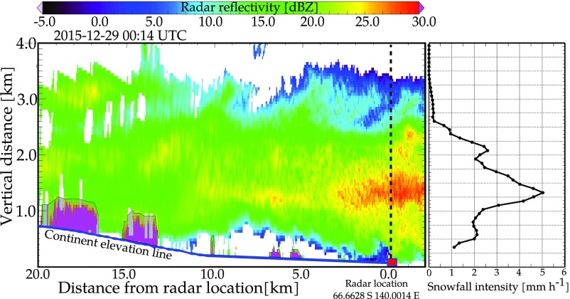
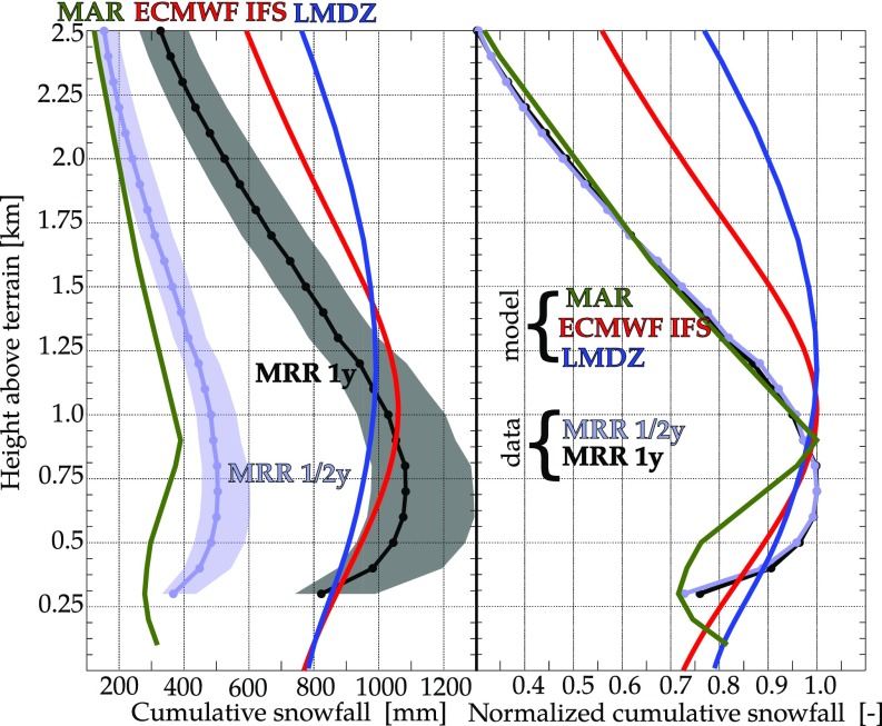
Our observations at DDU consistently show that snowfall is frequently either not reaching the ground (virga) or strongly decreasing in intensity in the lower kilometer of the atmosphere (Fig. 1). This suggests that the precipitation undergoes a significant sublimation process close to the ground. Daily losses of precipitation mass over the vertical column caused by sublimation can get close to 100% when snowfall intensities at the ground level are low and decrease to about 20% in the most intense snowfall cases (Fig. S1). The available remote sensing measurements over a full year exhibit a clear signal of low-level sublimation: the maximum snowfall accumulation occurs ∼0.7 0.05 km above the surface, just above the typical top height of the katabatic flow coming from the inner continent, while near the surface, yearly accumulation values are about 25% lower than the maximum ones (Fig. 2).
Fig. 1.
Evidence of low-level sublimation from a vertical cross-section of weather radar measurements performed in DDU on December 29, 2015. The cross-section is conducted in the direction of the Antarctic plateau at a true azimuth of 203°. The variable that is color-coded in the cross-section is the radar reflectivity (expressed in dBZ) linked to snowfall rate through a power law (details are in Materials and Methods), while snowfall intensity in a column over the radar location is shown as an individual profile. The areas where radar measurements are corrupted by ground clutter over the continent are shadowed in gray.
Fig. S1.
Relative loss of precipitation at the daily scale as a function of daily precipitation intensity as measured by the MRR radar and simulated with the ECMWF IFS model over the year of interest (November of 2015 to October of 2016). Relative loss at the daily scale is the difference between the maximum accumulation of precipitation over the vertical column and the near-ground accumulation normalized by the maximum accumulation. The solid lines correspond to median values, and the shaded areas correspond to the interquantile range from 10 to 90%. Statistics are computed over bin sizes of 0.1 mm . If fewer than 20 measurements fell into a bin, the bin size was increased by 10% iteratively until it contained at least 20. We can observe that events of higher intensity are relatively less affected by low-level sublimation.
Fig. 2.
Cumulative snowfall as a function of height above terrain in DDU as obtained by ground-based radar measurements and numerical atmospheric models. We obtained the curves over the 1-y period from November of 2015 to October of 2015 (MRR 1y, LMDZ, and ECMWF IFS) or the half-year period from November of 2015 to May of 2016 (MAR and MRR 1/2y). Left shows absolute cumulative snowfall curves, while Right shows the same curves normalized by their respective maximum value. The three models (ECMWF, MAR, and LMDZ) run at different resolutions, and with different physical parametrizations, all show low-level sublimation.
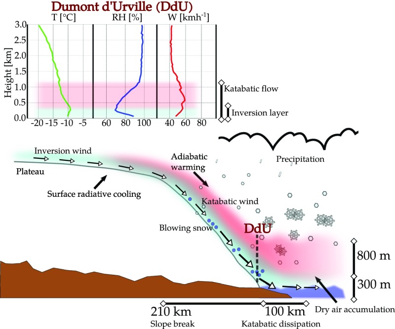
These observations give us insight into the origin of this process of low-level sublimation of precipitation (LSP) observed in the data, which is driven by the wind regime and atmospheric stratification near the ground level. Close to the surface, the wind is usually strong enough to lift and recirculate deposited snow, and air is moistened and often saturated by the sublimation of drifting and blowing snow (14, 15) that can be lifted up to (but rarely exceeds) 300 m above the surface (16) (Fig. 3). Because of the temperature inversion at the top of this near-saturation layer, the air above remains dry and unsaturated (below roughly 1,200 m for DDU). Aloft (1,200 m), saturation or oversaturation is the necessary condition for the nucleation and growth of ice crystals up to the size required to precipitate. The air coming from the continent accelerates as the slope of the terrain becomes steeper, associated with adiabatic warming (17, 18). This adiabatic warming further enhances subsaturation in the dry layer by decreasing the relative humidity of the descending air mass. In the very proximity of the ocean, where the slope of the terrain abruptly decreases to zero, the katabatic airflow slows down. The dry air accumulates and gradually saturates until the structure of the dry layer observed over the escarpment and near the coasts is dissipated over the ocean (18). Because of the persistent outflow and accumulation of dry air, the margins of the Antarctic continent, where precipitation is much higher than on the elevated plateau, are the areas where snowfall sublimation is the most important (Fig. S2).
Fig. 3.
Mechanisms leading to sublimation enhancement over the coastal locations at the margin of the Antarctic ice sheet. The spatial scales are approximated from the section crossing DDU in the direction of maximum slope toward the plateau. Accumulation of air with low relative humidity near the Antarctic margins leads to an enhancement of sublimation. The curves of relative humidity (RH), temperature (T), and wind speed (W) correspond to the median profiles of these variables obtained from the daily radiosonde measurements conducted at 00 UTC for the period from November of 2015 to November of 2016 conditioned on precipitation occurrence. They highlight the typical stratification of the atmosphere during snowfall events at this location.
Fig. S2.
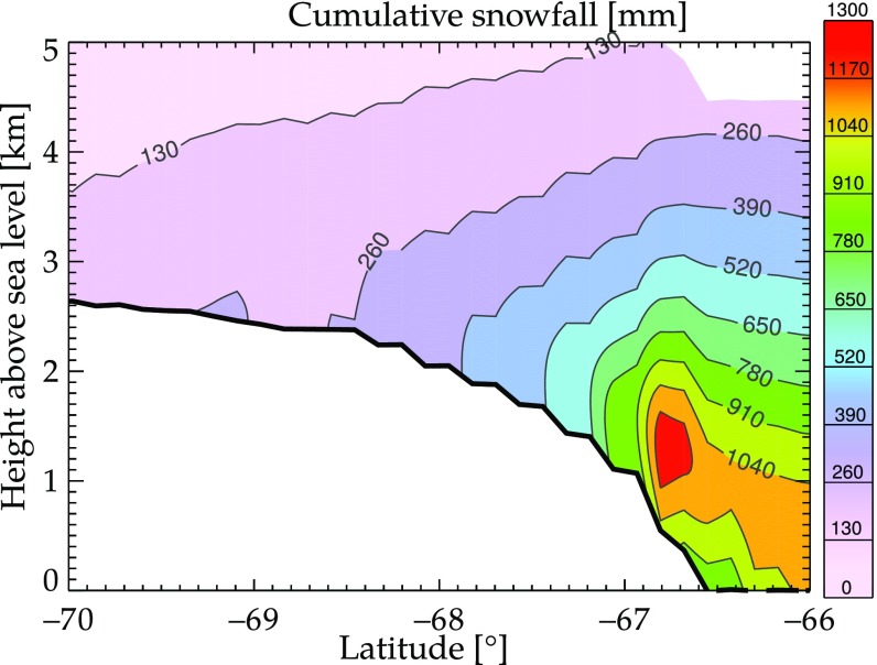
Cross-section of 1-y (November of 2015 to October of 2016) cumulative snowfall obtained with the ECMWF IFS model. The section crosses the location of the DDU station (66.6628 °S, 140.0014 °E), and it is drawn approximately in the direction of maximum slope toward the Antarctic plateau. This figure is a 2D representation of what is shown in Fig. 2. Close to the margin of the ice sheet, maximum accumulation does not occur at near-ground heights. Fig. 3 illustrates the mechanism leading to this vertical structure.
LSP at the Continental Scale.
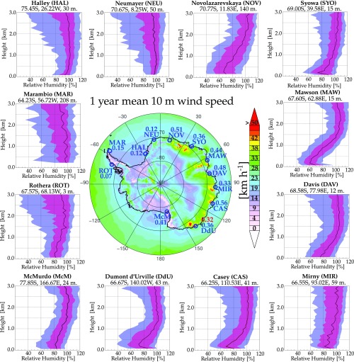
The analysis above shows the importance of the LSP mechanism on total precipitation at DDU. What about the rest of Antarctica? Measurements of vertical profiles of precipitation being very rare (collected at three locations so far), the same approach cannot be used to investigate LSP at the continental scale. A first important indication is given by the analysis of the long records of radiosounding data available in Antarctica: katabatic winds and an unsaturated low-level troposphere are observed over the majority of the margins of East Antarctica as shown in the sounding statistics in Fig. S3. Favorable conditions for the occurrence of the LSP mechanism hence do exist in Antarctic regions other than Adélie Land. To study the LSP mechanism at the Antarctic continental scale and given the very few precipitation datasets collected so far in Antarctica, we, therefore, use output from three different and complementary atmospheric models (Materials and Methods): a high-resolution research model [Modèle Atmosphérique Régional (MAR)], an operational global model [European Centre for Medium-Range Weather Forecasts Integrated Forecast System (ECMWF IFS)], and a global climate model [Laboratoire de Météorologie Dynamique Zoomed (LMDZ)], which is the atmospheric component of an Earth System Model used in CMIP5 (19). The simulations of all three atmospheric models reproduced a similar structure of precipitation with respect to the observations, although the height of the snowfall maximum varies between 0.9 and 1.2 km above the surface and the amplitude of the losses is lower than observed. This points to a robust dynamical origin of the process, which is, therefore, not strongly affected by differences between the models’ parameterizations of microphysical processes. MAR, at 5-km resolution, better reproduces the full vertical structure of precipitation and better matches the location of the maximum and the amplitude of sublimation, while ECMWF IFS (10 km) and LMDZ (70 km) locate the maximum higher and reproduce a smoother cumulative precipitation profile, probably because of their lower spatial resolution. Blowing snow in MAR is assigned to the same water category as snowflakes. This explains the apparent increase of precipitation below 300 m of altitude, because blowing snow and precipitation particles cannot be separated in the model. The ECMWF IFS model does not consider blowing snow and its feedback on air humidity, but it assimilates the atmospheric soundings data over several locations in Antarctica. Differences between the three models above the level of maximum snowfall (Fig. 2) result from the various microphysical parametrizations and cloud-to-snow conversion rates used by the models.
Fig. S3.
Map of 1-y mean wind speed in Antarctica from the ECMWF IFS model. Highlighted on the map are the locations of 12 scientific stations where atmospheric balloon soundings are conducted daily. The blue number close to the acronym of each station indicates the value of sublimation ratio as in Fig. 4C. For the DDU station, in red, the estimate of sublimation ratio from MRR measurements down to 300 m above ground is also shown. A separate panel for each of the locations shows the statistics corresponding to 10 y of data of relative humidity with respect to ice as a function of height above sea level. The statistics are conditioned on precipitation occurrence based on the ERA-Interim reanalysis. The solid black lines indicate median values, the red shaded area indicates the interquantile range from 25 to 75%, and the blue shaded area indicates the interquantile range from 10 to 90%. Statistics are computed for each bin of 0.1 km, and at least 100 measurements are contained in each bin.
By looking at the simulations of the ECMWF IFS model over the entire continent, we observe that, in several regions forming a belt around the margin of East Antarctica, more than 40% of the snowfall sublimates in the lower kilometer of the atmosphere before reaching the ground (Fig. 4 and Fig. S3). Sublimation larger than 30% in relative terms is also observed over many ice shelves, but the absolute amounts sublimated at these locations are at least an order of magnitude smaller than the values observed on the margins of East Antarctica. Given the proximity to the mountain ranges of the Antarctic Peninsula, foehn winds may play a role in the case of the Larsen ice shelf (20), and the accumulation of air originating on the plateau and crossing the trans-Antarctic mountains may affect the Ross ice shelf (21) as well. Finally, the contribution of sublimation is low both in relative and in absolute terms on the elevated part of the continent, and a clear link with topography through wind channeling is observed, especially on the margins of East Antarctica (Fig. 4). We estimate from ECMWF IFS simulations that, over the year of measurements (November of 2015 to November of 2016), at least 651 Gt water equivalent snowfall sublimated because of the LSP process described above. This corresponds to 17% of the total snowfall on the entire Antarctic continent never reaching the ground. It is worth noting that this percentage has roughly the same magnitude (10–15%) as the estimated proportion of snow sublimating after deposition (13, 22). On the margins of East Antarctica (defined here from 30 °W to 150 °E), where snowfall accumulation is larger than in the interior, the contribution of snowfall sublimation is larger: 35% for all of the regions where the surface is lower than 1 km above sea level.
Fig. 4.
Quantification of the contribution of sublimation of snowfall over the Antarctic continent. The accumulated sublimation over the year of interest (November of 2015 to October of 2016) is obtained from a series of daily 24-h forecasts from the operational ECMWF IFS model. (A) Total yearly snowfall reaching the ground level. (B) Absolute yearly contribution of sublimation. (C) Sublimation ratio: ratio of total sublimated snowfall over maximum snowfall in the vertical column. The solid blue line indicates a ground altitude of 1,000 m above sea level. Details are provided in Materials and Methods. It is worth mentioning that snowfall values over the Antarctic peninsula and in some locations of East Antarctica are often larger than 1,000 mm. The color scale is limited at 1,000 mm to enhance readability.
Discussion and Conclusion
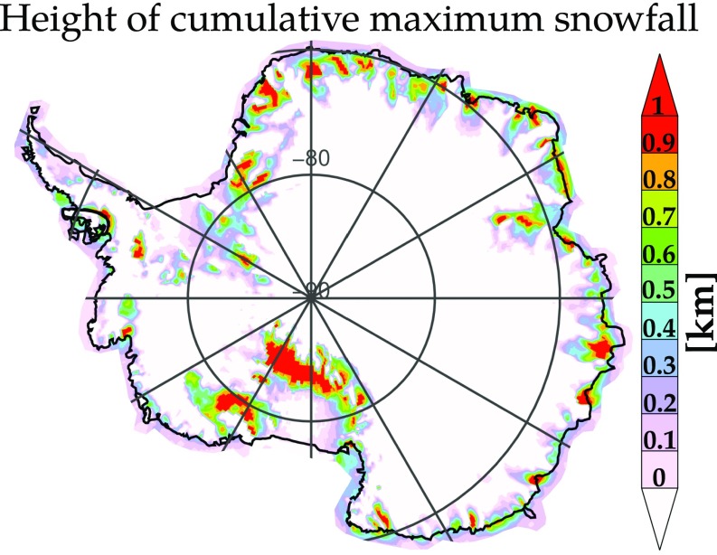
The influence of LSP on the vertical structure of precipitation raises the question of the interpretation of satellite-borne radar precipitation measurements over the Antarctica continent (23, 24) that are currently the only model-free source of information able to cover the entire continent. These measurements must be discarded close to the surface because of ground clutter contamination of the radar signal (24), and the measurements at a certain height (1.2 km for CloudSat and around 0.8 km expected for EarthCare) above the surface are used as a proxy for near-ground precipitation. The vertical structure in Fig. 2 and the sublimation belt observed in Fig. 4 suggest that satellite retrievals overestimate precipitation in the areas where sublimation dominates the low-level structure of precipitation in the satellite blind range. As shown in Fig. S4, the expected biases of satellite estimates are indeed nonuniformly distributed over the continent, with significant overestimations that can be on the order of 50% in the areas of katabatic channeling as a consequence of the nonuniform distribution of the height of LSP (Fig. S5).
Fig. S4.
Quantification of the expected bias in satellite-based estimates as a consequence of the satellite blind range only for a 1-y period (November of 2015 to October of 2016). The bias is calculated using ECMWF IFS data, and it is defined as the difference between cumulative snowfall at the blind range minus the cumulative snowfall reaching the ground (normalized by the ground value). (A) Blind range of 800 m. (B) Blind range of 1,200 m.
Fig. S5.
Height of the maximum cumulative snowfall over continental Antarctica using ECMWF IFS model data over the year from November of 2015 to October of 2016. This height is defined as the height where the curve in Fig. 2 reaches its maximum.
While LSP is significant in Antarctica, we anticipate that favorable conditions may also exist in the Arctic. The occurrence of low-level sublimation in the Arctic has been hypothesized (25), and recent remote sensing measurements (26) showed precipitation structures similar to the ones that we observed in Antarctica. The LSP mechanism leading to the observed sublimation belt will be sensitive to climate change. Warming currently affects mostly West Antarctica, but it is expected to affect East Antarctica in the coming decades (27). The nonlinearity of the Clausius–Clapeyron effect implies that a temperature increase over the coastal regions leads to a much larger increase of absolute humidity to reach saturation than the same temperature increase over the colder plateau. Indeed, an increase in temperature of 1 °C results in an increase of saturation vapor pressure with respect to ice about six times larger at −10 °C than at −30 °C, with all else unchanged. Because the low-level air of the Antarctic margins originates from the colder plateau, the degree of subsaturation of this layer will increase in a warming climate. On one hand, increased moisture-holding capacity of the atmosphere at higher temperatures tends to increase snowfall amounts (2, 28–30). On the other hand, changes in synoptic wind patterns and dynamics also modulate the signal (31). Our results show that additional complexity arises from the changes in moisture and strengths of katabatic winds. The evolution (and sensitivity) of snowfall with climate change in Antarctic coastal regions already affected by ice loss from their ice shelves (32) will depend on large-scale atmospheric feedbacks as well as on local changes in katabatic winds. An increase in LSP associated with warmer temperatures could partly counterbalance snowfall increase on the margins of the continent by decreasing the fraction of snowfall that reaches the ground.
Low-level sublimation of snowfall involves a mass of water of at least the same magnitude as for processes occurring after ground deposition. Given this magnitude and in the light of future climate scenarios, our study shows that snowfall sublimation should be explicitly considered and monitored as an individual term of the ice sheet mass balance.
Materials and Methods
Radar Data in DDU.
The raw data collected with a vertically pointing K-band Micro Rain Radar (MRR) (33) were processed with the algorithm detailed in ref. 34 and then converted to snowfall rate with a relation trained locally at the time resolution of 1 h. The profile of Fig. 2 has been obtained by cumulating the profiles for the period ranging from November 22, 2015 to November 12, 2016 (MRR 1 y) and from November 22, 2015 to May 31, 2016 (MRR 1/2 y). The error range results from the confidence interval of the exponent and prefactor parameters of the reflectivity to snowfall rate power law. The power law takes the form , with reflectivity expressed in millimeters6 meter−3 and averaged at 1-h time resolution instead of the native resolution of the processed data that is 30 s. The snowfall rate is obtained in millimeters . MRR data were collected at 100-m (vertical) radial resolution, and the first valid measurement, which is used as a proxy for a near-ground value, is collected at the third range gate. The center of this gate is, therefore, 300 m above ground, and the gate covers the height range 300 50 m. The reflectivity data collected by a second (X-band) radar system were used as a reference to validate and calibrate the MRR measurements. The X-band polarimetric radar was deployed from December of 2015 to February of 2016, and as a scanning radar, it was able to provide the spatial information shown in Fig. 1. Detailed information about the radar data collected in DDU and their conversion into snowfall intensity can be found in ref. 9.
Numerical Weather Model Data.
The models used in the study were ECMWF IFS, MAR, and LMDZ.
The operational global numerical weather prediction system at the ECMWF IFS provides twice daily high-resolution analysis and forecasts with a grid spacing of ∼10 km. The versions of the forecast model during this period were 41r1 and 41r2 with 137 vertical levels and a first level at 10 m. The model has variables for cloud fraction, cloud liquid, cloud ice, rain, and snow and associated parameterizations of microphysical processes (35, 36). Here, we use a 3-h time series from short-range 24-h forecasts initialized at 00 coordinated universal time (UTC) every day for the year corresponding with the observations from November of 2015 to November of 2016. The effects of spin up of precipitation in the first hours of the forecast have been verified to be, for the domain of interest, negligible. The data are interpolated to a 0.25° latitude/longitude grid for faster processing. For the analysis in Fig. 4 and Figs. S2 and S3, we used ECMWF IFS, because data were available on the entire Antarctic domain, and they include the assimilation of available measurements. At DDU, where reference observations have been collected by the MRR down to 300 m above ground (minimum observable height), the total sublimation from ECMWF IFS, down to 300 m above ground as well, is about 27%, while it is 32% from MRR data. ECMWF IFS sublimation down to 10 m above ground (as shown in Fig. 4C and Fig. S3) is 36%. It is worth noting that ECMWF IFS does not directly simulate blowing snow that leads to resaturation of the lowest layer of the atmosphere (37) but assimilates atmospheric soundings where this resaturation appears (Fig. 3 and Fig. S3).
MAR is a limited area atmosphere, blowing snow, and snow pack coupled research model. Atmospheric dynamics is based on the hydrostatic approximation of the primitive equations (38), and the parameterization of turbulence in the surface boundary layer takes into account the stabilization effect of the blowing snow flux (39). The blowing snow model used in MAR is described in refs. 40 and 41. MAR was set up over Adélie Land (Antarctica), with a horizontal resolution of 5 km over 136 136 grid points. Lateral forcing and sea surface conditions were taken from the global reanalysis (called ERA-Interim) provided by the ECMWF (42). There were 26 levels in the vertical, with a higher vertical resolution in the low troposphere. The first level is situated very close to the ground (0.15 m), as blowing snow is explicitly modeled. The simulation shown in Fig. 3 was performed from the November 1, 2015 to May 31, 2016.
The LMDZ global climate model was run using a zoom over the region of the DDU station and a 6-h relaxation of the winds to ECMWF reanalysis data. This relaxation was active outside the stretched domain to represent the global synoptic conditions and progressively reduced inside the domain. The model was run with a horizontal resolution of 70 km in the vicinity of the station and 79 vertical levels, with a first level at 8 m. Cloud and precipitation physics of the model are described in ref. 43.
With the first model elevation above the surface ranging from less than 1 m to up to 10 m, different vertical resolutions in the different models can also contribute to different reproduction of the vertical structure of precipitation.
Radiosounding Data.
We used atmospheric sounding data in Fig. 3 and Fig. S3. The data are made freely available by the University of Wyoming Department of Atmospheric Science (weather.uwyo.edu/upperair/sounding.html) for several sounding stations. The relative humidity with respect to water was converted to relative humidity with respect to ice taking into account the temperature of air (44, 45). The curves in Fig. 3 represent the same measurement period as the MRR radar data, and they are conditioned on precipitation occurrence using the MRR as a reference. The statistics displayed in Fig. S3 cover the period from 2005 to 2016. In this case, as no in situ data are available, they are conditioned on precipitation occurrence from ERA-Interim, which is thought to provide the best reconstruction of precipitation (46). The threshold on precipitation accumulation used to discriminate precipitation occurrence was 0.07 mm in 6 h as suggested for this reanalysis (23).
Quantification of Total Sublimation.
The quantification of sublimation was obtained from the vertical profiles of snowfall intensity. The difference between the maximum snowfall accumulation over the vertical column at a daily timescale and the near-ground accumulation is taken as a proxy for the total sublimation.
Fig. 2, for what concerns the models, is obtained by accumulating snowfall over the same period as when MRR data were available. The total sublimation ratio, shown in Fig. 4A, was obtained by accumulation over 1 y of data aggregated at the daily scale as explained below. For each day and at each grid point, we calculated the maximum snowfall accumulation over the vertical column (in millimeters) and the total near-ground accumulation (in millimeters). The height levels vary slightly from profile to profile at the subdaily scale, as they result from the conversion of model levels to heights above ground that depend on the temperature and pressure at these levels. For this reason, they are linearly interpolated into a regular grid ranging from 10 to 4,500 m above ground for the sake of homogeneity. The analysis excludes all profiles that have a positive temperature in degrees Celsius to avoid the process of snow to rain conversion being confused with snowfall sublimation; 0.42% of the profiles over continental Antarctica are removed in this way, with maximum values becoming significant (up to 30%) at the lowest latitude of West Antarctica on the Antarctic Peninsula. The total sublimation ratio in Fig. 4C is obtained over days as
| [1] |
The total sublimation in Fig. 4B for the period under analysis is given by the numerator of Eq. 1. Therefore, the estimation of sublimation is based on daily data. At subdaily scales, the contribution of sublimation can be even larger.
Acknowledgments
We thank the French Polar Institute, which logistically supported the Antarctic Precipitation: Remote Sensing from Surface and Space (APRES3) measurement campaign. We also thank the University of Wyoming Department of Atmospheric Science for their service in providing atmospheric sounding data and Météo France for the soundings at Dumont d’Urville. We thank Florentin Lemonnier (Laboratoire de Météorologie Dynamique) for the LMDZ runs that he performed and the development team of LMDZ for their major contribution to the improvements of the code: Jean-Yves Grandpeix, Frédéric Hourdin, Catherine Rio, and Etienne Vignon for their contributions to the parametrization of clouds and winds and all of the engineers who allowed LMDZ to run. We are also grateful to T. Battin and A. Rinaldo for their help on an earlier version of this manuscript. J.G. thanks the Swiss National Science Foundation (Grant 200021_163287) for financing his participation in the project. We also acknowledge the support of the French National Research Agency to the APRES3 project. The project Expecting Earth-Care, Learning from A-Train (EECLAT) funded by the Centre National d’Etudes Spatiales (CNES) also contributed support to this work. MAR simulations were performed using high performance computing resources from the French Big National Equipment Intensive Computing (GENCI) from the Institut du Développement et des Ressources en Informatique Scientifique (IDRIS) (Grant 2017-1523) and the High-Performance Computing/Modeling/Numerical and Technological experimentation infrastructure (CIMENT), which is supported by the Rhône-Alpes region (Grant CPER07_13 CIRA).
Footnotes
The authors declare no conflict of interest.
This article is a PNAS Direct Submission.
This article contains supporting information online at www.pnas.org/lookup/suppl/doi:10.1073/pnas.1707633114/-/DCSupplemental.
References
- 1.Bengtsson L, Koumoutsaris S, Hodges K. Large-scale surface mass balance of ice sheets from a comprehensive atmospheric model. Surv Geophys. 2011;32:459–474. [Google Scholar]
- 2.Winkelmann R, Levermann A, Martin MA, Frieler K. Increased future ice discharge from Antarctica owing to higher snowfall. Nature. 2012;492:239–242. doi: 10.1038/nature11616. [DOI] [PubMed] [Google Scholar]
- 3.Shepherd A, et al. A reconciled estimate of ice-sheet mass balance. Science. 2012;338:1183–1189. doi: 10.1126/science.1228102. [DOI] [PubMed] [Google Scholar]
- 4.Mengel M, Levermann A. Ice plug prevents irreversible discharge from East Antarctica. Nat Clim Change. 2014;4:451–455. [Google Scholar]
- 5.DeConto RM, Pollard D. Contribution of Antarctica to past and future sea-level rise. Nature. 2016;531:591–597. doi: 10.1038/nature17145. [DOI] [PubMed] [Google Scholar]
- 6.Kennicutt MCI, et al. Polar research: Six priorities for Antarctic science. Nature. 2014;512:23–25. doi: 10.1038/512023a. [DOI] [PubMed] [Google Scholar]
- 7.Gorodetskaya IV, et al. Cloud and precipitation properties from ground-based remote-sensing instruments in East Antarctica. Cryosphere. 2015;9:285–304. [Google Scholar]
- 8.Witze A. Climate science Antarctic cloud study takes off. Nature. 2016;529:12. [Google Scholar]
- 9.Grazioli J, et al. Measurements of precipitation in Dumont d’Urville, Adélie land, East Antarctica. Cryosphere. 2017;11:1797–1811. [Google Scholar]
- 10.Wendler G, Stearns C, Weidner G, Dargaud G, Parish T. On the extraordinary katabatic winds of Adélie land. J Geophys Res Atmos. 1997;102:4463–4474. [Google Scholar]
- 11.Parish TR, Bromwich DH. Reexamination of the near-surface airflow over the Antarctic continent and implications on atmospheric circulations at high southern latitudes. Mon Weather Rev. 2007;135:1961–1973. [Google Scholar]
- 12.Bintanja R, Severijns C, Haarsma R, Hazeleger W. The future of Antarctica’s surface winds simulated by a high-resolution global climate model: 1. Model description and validation. J Geophys Res Atmos. 2014;119:7136–7159. [Google Scholar]
- 13.van den Broeke MR. Spatial and temporal variation of sublimation on Antarctica: Results of a high-resolution general circulation model. J Geophys Res Atmos. 1997;102:29765–29777. [Google Scholar]
- 14.Barral H, Genthon C, Trouvilliez A, Brun C, Amory C. Blowing snow in coastal Adélie land, Antarctica: Three atmospheric-moisture issues. Cryosphere. 2014;8:1905–1919. [Google Scholar]
- 15.Groot ZwaaftinkC, Löwe H, Mott R, Bavay M, Lehning M. Drifting snow sublimation: A high-resolution 3-D model with temperature and moisture feedbacks. J Geophys Res. 2011;116:D16107. [Google Scholar]
- 16.Palm SP, Yang Y, Spinhirne JD, Marshak A. Satellite remote sensing of blowing snow properties over Antarctica. J Geophys Res. 2011;116:D16123. [Google Scholar]
- 17.Bromwich DH. Satellite analyses of Antarctic katabatic wind behavior. Bull Am Meteorol Soc. 1989;70:738–749. [Google Scholar]
- 18.Gallée H, Pettre P. Dynamical constraints on katabatic wind cessation in Adélie land, Antarctica. J Atmos Sci. 1998;55:1755–1770. [Google Scholar]
- 19.Dufresne JL, et al. Climate change projections using the IPSL-CM5 Earth system model: From CMIP3 to CMIP5. Clim Dynam. 2013;40:2123–2165. [Google Scholar]
- 20.Elvidge AD, et al. Foehn jets over the Larsen C ice shelf, Antarctica. Q J Roy Meteorol Soc. 2015;141:698–713. [Google Scholar]
- 21.Jolly B, et al. A validation of the Antarctic mesoscale prediction system using self-organizing maps and high-density observations from SNOWWEB. Mon Weather Rev. 2016;144:3181–3200. [Google Scholar]
- 22.Genthon C, Krinner G. Antarctic surface mass balance and systematic biases in general circulation models. J Glaciol. 2001;106:20653–20664. [Google Scholar]
- 23.Palerme C, et al. How much snow falls on the Antarctic ice sheet? Cryosphere. 2014;8:1577–1587. [Google Scholar]
- 24.Maahn M, et al. How does the spaceborne radar blind zone affect derived surface snowfall statistics in polar regions? J Geophys Res Atmos. 2014;119:13604–13620. [Google Scholar]
- 25.Burford JE, Stewart RE. The sublimation of falling snow over the Mackenzie river basin. Atmos Res. 1998;49:289–313. [Google Scholar]
- 26.Henson W, Stewart R, Hudak D. Vertical reflectivity profiles of precipitation over Iqaluit, Nunavut during autumn 2007. Atmos Res. 2011;99:217–229. [Google Scholar]
- 27.Mayewski PA, et al. State of the Antarctic and Southern Ocean climate system. Rev Geophys. 2009;47:RG1003. [Google Scholar]
- 28.Huybrechts P, Gregory J, Janssens I, Wild M. Modelling Antarctic and Greenland volume changes during the 20th and 21st centuries forced by GCM time slice integrations. Glob Planet Change. 2004;42:83–105. [Google Scholar]
- 29.Hanna E, et al. Ice-sheet mass balance and climate change. Nature. 2013;498:51–59. doi: 10.1038/nature12238. [DOI] [PubMed] [Google Scholar]
- 30.Frieler K, et al. Consistent evidence of increasing Antarctic accumulation with warming. Nat Clim Change. 2015;5:348–352. [Google Scholar]
- 31.Krinner G, Magand O, Simmonds I, Genthon C, Dufresne JL. Simulated Antarctic precipitation and surface mass balance at the end of the twentieth and twenty-first centuries. Clim Dynam. 2007;28:215–230. [Google Scholar]
- 32.Paolo FS, Fricker HA, Padman L. Volume loss from Antarctic ice shelves is accelerating. Science. 2015;348:327–331. doi: 10.1126/science.aaa0940. [DOI] [PubMed] [Google Scholar]
- 33.Peters G, Fischer B, Munster H, Clemens M, Wagner A. Profiles of raindrop size distributions as retrieved by microrain radars. J Appl Meteorol. 2005;44:1930–1949. [Google Scholar]
- 34.Maahn M, Kollias P. Improved micro rain radar snow measurements using Doppler spectra post-processing. Atmos Meas Tech. 2012;5:2661–2673. [Google Scholar]
- 35.Tiedtke M. Representation of clouds in large-scale models. Mon Weather Rev. 1993;121:3040–3061. [Google Scholar]
- 36.Forbes RM, Ahlgrimm M. On the representation of high-latitude boundary layer mixed-phase cloud in the ECMWF global model. Mon Weather Rev. 2014;142:3425–3445. [Google Scholar]
- 37.Thiery W, et al. Surface and snowdrift sublimation at Princess Elisabeth station, East Antarctica. Cryosphere. 2012;6:841–857. [Google Scholar]
- 38.Gallée H, Schayes G. Development of a 3-dimensional meso-gamma primitive equation model katabatic winds simulation in the area of Terra-Nova bay, Antarctica. Mon Weather Rev. 1994;122:671–685. [Google Scholar]
- 39.Gallée H, Guyomarc’h G, Brun E. Impact of snow drift on the Antarctic ice sheet surface mass balance: Possible sensitivity to snow-surface properties. Bound Lay Meterol. 2001;99:1–19. [Google Scholar]
- 40.Gallée H, et al. Transport of snow by the wind: A comparison between observations in Adélie land, Antarctica, and simulations made with the regional climate model MAR. Bound Lay Meterol. 2013;146:133–147. [Google Scholar]
- 41.Amory C, et al. Comparison between observed and simulated aeolian snow mass fluxes in Adelie land, East Antarctica. Cryosphere. 2015;9:1373–1383. [Google Scholar]
- 42.Dee DP, et al. The ERA-Interim reanalysis: Configuration and performance of the data assimilation system. Q J Roy Meteorol Soc. 2011;137:553–597. [Google Scholar]
- 43.Hourdin F, et al. LMDZ5B: The atmospheric component of the IPSL climate model with revisited parameterizations for clouds and convection. Clim Dynam. 2013;40:2193–2222. [Google Scholar]
- 44.Buck AL. New equations for computing vapor-pressure and enhancement factor. J Appl Meteorol. 1981;20:1527–1532. [Google Scholar]
- 45.Andreas EL, et al. Near-surface water vapor over polar sea ice is always near ice saturation. J Geophys Res Oceans. 2002;107:SHE 8-1–SHE 8-15. [Google Scholar]
- 46.Bromwich DH, Nicolas JP, Monaghan AJ. An assessment of precipitation changes over Antarctica and the Southern Ocean since 1989 in contemporary global reanalyses. J Clim. 2011;24:4189–4209. [Google Scholar]


