

Abstract
A Late Pleistocene hominin tracksite has been identified in coastal aeolianite rocks on the Cape south coast of South Africa, an area of great significance for the emergence of modern humans. The tracks are in the form of natural casts and occur on the ceiling and side walls of a ten-metre long cave. Preservation of tracks is of variable quality. Up to forty hominin tracks are evident. Up to thirty-five hominin tracks occur on a single bedding plane, with potential for the exposure of further tracks. Five tracks are apparent on a second hominin track-bearing bedding plane. A number of individuals made the tracks while moving down a dune surface. A geological investigation at the site and stratigraphic comparison to published geochronological studies from this area suggest that the tracks are ~90 ka in age. If this is the case, the shoreline at the time would have been approximately 2 km distant. This is the first reported hominin tracksite from this time period. It adds to the relatively sparse global record of early hominin tracks, and represents the largest and best preserved archive of Late Pleistocene hominin tracks found to date. The tracks were probably made by Homo sapiens.
Introduction
The Cape south coast of South Africa has one of the richest Middle Stone Age archaeological records in the world, and is of high importance to modern human origins. Sea cliff caves, rock shelters, and open-air sites on the exposed landscape hold archives of early humans1,2. The emergence of modern humans in southern Africa is a subject of considerable interest, and the Cape south coast figures prominently in this research2–6. These sites provide early evidence for art and jewelry3,4, stone tool heat treatment7, microlithic technology8, and the first systematic use of seafood in the human diet1. In addition, inferences on palaeoclimate9,10 and palaeolandscape11,12 suggest that factors such as the confluence of ocean currents, the broad continental shelf and sweeping plain, and vegetation supported by the geological substrate, may have been conducive to the survival of coastal Pleistocene hominin communities.
The potential for ichnology to contribute to such research has been limited by the sparse record of early hominin tracksites. The most comprehensive summaries of such sites include a table of 63 previously known hominin tracksites13, a table of 44 sites14, and an ichnological summary of major events in hominin evolution15. Based on these tables, known early hominin tracksites prior to the discovery of the site we describe, in order of decreasing age, and with purported trackmaker, included:
Laetoli, Tanzania (~3,660 ka): Australopithecus afarensis
Ileret, Kenya (~1,500 ka): Homo erectus
Koobi Fora, Kenya (~1,400 ka): Homo erectus
Happisburgh, United Kingdom (~1,000–780 ka): Homo antecessor
Roccamonfina Volcano, Italy (~385–325 ka): Homo heidelbergensis
Terra Amata, France (~300 ka): Homo erectus
Nahoon, South Africa (~126 ka): Homo sapiens sapiens
Langebaan, South Africa (~117 ka): Homo sapiens sapiens
Vârtop Cave, Romania (constrained to 62–97 ka): Homo neanderthalensis
-
Theopetra Cave, Greece (~46 ka): Homo sapiens sapiens.
Thereafter many more recent sites follow, from all continents except Antarctica. We note that the tables of Lockley et al.13 and Bennett and Morse14 do not include the enigmatic, undated “Queen Nzinga’s footprints” at Pungo Andongo in Angola16.
Rigour is required in the attribution of tracks to hominins. Tuttle17 developed criteria for the identification of hominin tracks:
the hallux (big toe) is aligned with the four lateral toes, which are short and straight
the tip of the hallux is bulbous, not tapered
the tips of the hallux and adjacent second and third toes do not project markedly beyond one another
a prominent medial longitudinal arch is evident.
Published research on South African Pleistocene trackways has largely centred on the two above-mentioned hominin tracksites (Nahoon and Langebaan) and nearby associated vertebrate tracks18,19, plus on elephant trackways20,21. Both South African hominin tracksites contained three human tracks. The first site was discovered in 1964 at Nahoon, 600 km to the east of the site we describe22. It collapsed soon after its discovery. The tracks were recovered, and are housed in the East London Museum19,23. The second site, near Langebaan, 400 km to the west of the site we describe, was discovered in 199719,24. The tracks are housed in the Iziko South Africa Museum, Cape Town. Both these sets of tracks were found in aeolianite deposits which date to the last interglacial period, Marine Isotope Stage (MIS) 5e. The Nahoon site has been dated to ~126 ka, and the Langebaan site to ~117 ka19. They have been thought to represent the first known tracks made by our own subspecies, Homo sapiens sapiens. However, this assumption was made prior to the description of a second southern African hominin species (Homo naledi) from skeletal material from the Rising Star Cave25 (more than 750 km north of these sites, and a linear distance of more than 1000 km from the site we describe) and its subsequent dating, which provides an estimated minimum age of 236 ka26.
The general prevalence and significance of MIS 5 aeolianites along the Cape south coast has been discussed extensively in the literature19,27,28. The hominin tracksite we describe is the first on the Southern Coastal Plain, and is situated between the Nahoon and Langebaan sites.
The hominin tracks reported here were discovered as part of a ground survey by the senior author along a 275 km stretch of coastline from Witsand in the west to Robberg in the east, undertaken between 2007 and 2016 (Fig. 1). Over 100 Late Pleistocene vertebrate tracksites were identified in coastal aeolianites, and in 2016 natural cast tracks on the ceiling of a ten-metre long cave (Fig. 2) (see Supplementary Figs S2–S5) were identified as human in origin. In 2017 further hominin tracks were identified in this cave on a lower layer. The focus of this paper is to describe these tracks and to briefly place them in their sedimentary and palaeoecological context.
Figure 1.

Map of South Africa and the Cape south coast, showing sites discussed, created by co-author HC. SRTM (USGS, 2004, Shuttle Radar Topography Mission, 1 Arc Second scene SRTM_u03_n008e004, Unfilled Unfinished 2.0, Global Land Cover Facility, University of Maryland, College Park, Maryland, February 2000) 90 m resolution elevation data (http://www.cgiar-csi.org/data/srtm-90m-digital-elevation-database-v4-1) was overlain by Council for Geoscience 1:250,000 scale geological units of the Bredasdorp Group using ArcGIS software. The final figure was produced in CorelDrawX7 version 17.6.0.1021 (https://www.coreldraw.com/en/pages/free-download/).
Figure 2.

Entrance of cave containing hominin tracks, viewed from the intertidal zone (photograph by co-author ML).
Geological setting
The Late Pleistocene tracks reported here occur in coastal aeolianites, or fossil dune systems, which extend intermittently along much of the South African coastline and are best exposed in embayments on or near the shoreline21. Notable phases of dune construction in the current above-water record appear to be associated with regressive phases that followed sea-level high stands27,28, although deposits preserved on the continental shelf were associated with both transgressive and regressive sea-levelevents29.
Less than a quarter of the Cape south coast comprises aeolianite exposures30; the remainder of the geological substrate of the Southern Coastal Plain is dominated by Palaeozoic quartzite, sandstone and shale exposures of the Cape Supergroup, granite exposures of the Cape Granite Suite, and expanses of beach and unconsolidated Holocene beach and dune sediments. Aeolianites along the South African coast are sensitive barometers of fluctuations of palaeo-environmental dynamics, providing records of their orientation, geometry, palaeontology and archaeological content21. This record is enhanced by the identification of the tracks reported here.
The Late Pleistocene coastal trackways, including the hominin tracksite, occur in the Waenhuiskrans Formation, which belongs to the Bredasdorp Group31. Numerous dating studies have been performed on rocks of the Waenhuiskrans Formation through optically stimulated luminescence (OSL), Thermally Transferred OSL (TT-OSL) and amino acid racemisation (AAR) dating20,28,29,32,33. The majority of these dated aeolianites are from MIS 6 – MIS 5b, with two occurrences of MIS 11. The preservation bias to interglacials along the modern Southern Coastal Plain is, however, a function of the present high sea level regime34.
Quaternary tectonic activity has been considered minimal on the Cape south coast35,36, and the in situ bedding planes of the aeolianite hosting the hominin tracks lie close to their original angle of deposition, which is consistent with the angle of repose of wind-blown sands (~10°–30°)21.
Globally, the significance of coastal barrier systems and associated aeolianites in palaeo-environmental studies is well established37. They record the geomorphic evolution of coastal margins38–40 and coastal geomorphological responses to Pleistocene sea-level change41. In the South African context they are key to understanding Middle and Later Stone Age archaeological sites and the associated palaeo-environments that our ancestors occupied1,20,42.
Methods
Geological context was determined by standard field mapping of the exposure and outcrop. Primary sedimentary structures, including dip direction, were recorded for the construction of wind roses, samples were obtained for transmitted light microscopy, and the exposures were compared to adjacent deposits reported in previous investigations. Facies were described through analysis of the sediment grain characteristics and carbonate diagenetic signature. Stratigraphic comparison was performed to a dated site ~1 km distant (Castle Rock), and to the seaward cordon of the Wilderness Embayment (Fig. 1).
During the course of five site visits in 2016, a grid system was employed to create a sketch map of the track-bearing surfaces, along with a numbering system for the tracks. Photographs, Global Positioning System readings and compass bearings were obtained. Track and trackway measurements were recorded, and a cave survey was performed (see Supplementary Fig. S1). The tracks on the lower layer were measured in 2017.
Photogrammetry was performed using a Canon PowerShot ELFPH 340 HS camera. Point clouds and digital terrain models were compiled using Agisoft Photoscan Professional (v.1.0.4) and colour topographic profiles were created with CloudCompare (v.2.6.3.beta) (Figs 3 and 4). A track surface map was produced (Fig. 5).
Figure 3.
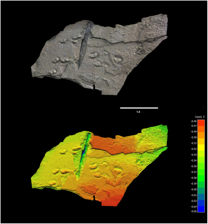
Photogrammetry of hominin tracks, southern surface. Top: photogrammetry mesh. Bottom: photogrammetry colour mesh. 3D model was generated with Agisoft Photoscan Professional (v. 1.0.4) using 200 images from a Canon PowerShot ELFPH 340 HS (Focal length 4.5 mm; resolution 4608 × 3456; pixel size of 1.33853 × 1.33853 um). Photos were taken average 0.54 metres from the surface. The surface model error is 0.131213pix. The final images presented here were rendered using CloudCompare (v.2.6.3.beta). Horizontal scale bar, representing x and y axes, is in metres. Vertical scale, representing z axis, is in metres.
Figure 4.
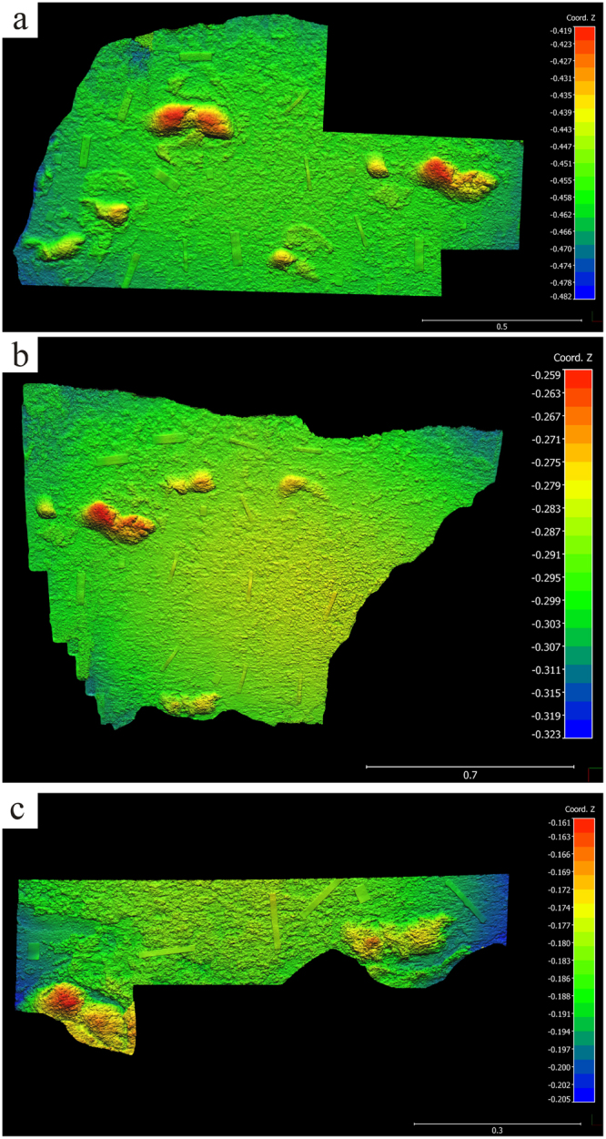
Photogrammetry of hominin tracks, northern surface. (a) Photogrammetry colour mesh of northern surface, proximal. 3D model was generated with Agisoft Photoscan Professional (v. 1.0.4) using 263 images from a Canon PowerShot ELFPH 340 HS (Focal lengths of 4.5 mm and 4.881 mm; resolution 4608 × 3456; pixel size of 1.33853 × 1.33853 um). Photos were taken average 0.41 metres from the surface. The surface model error is 0.150518 pix. The final images presented here were rendered using CloudCompare (v.2.6.3.beta). (b) Photogrammetry colour mesh of northern surface, distal. 3D model was generated with Agisoft Photoscan Professional (v. 1.0.4) using 198 images from a Canon PowerShot ELFPH 340 HS (Focal length 4.5 mm; resolution 4608 × 3456; pixel size of 1.33853 × 1.33853 um). Photos were taken average 0.45 metres from the surface. The surface model error is 0.132266pix. The final images presented here were rendered using CloudCompare (v.2.6.3.beta). The large track in figure is the same as the track on the far right of (a). (c) Photogrammetry colour mesh, detail of tracks in northern surface beside east wall. 3D model was generated with Agisoft Photoscan Professional (v. 1.0.4) using 155 images from a Canon PowerShot ELFPH 340 HS (Focal lengths of 4.5 mm – 5.082; resolution 4608 × 3456; pixel size of 1.33853 × 1.33853 um). Photos were taken average 0.17 metres from the surface. The surface model error is 0.153466pix. The final image presented here was rendered using CloudCompare (v.2.6.3.beta). The footprint at the far right of this figure is the same as the bottom-most print in (b). For (a,b) and (c), horizontal scale bar, representing x and y axes, is in metres. Vertical scale, representing z axis, is in metres.
Figure 5.

Map of track-bearing surface with rose diagram of track orientation, created by co-authors TP and RM, using Corel Draw X7, version 17.6.0.1021 (https://www.coreldraw.com/en/pages/free-download/).
The site was reported to Heritage Western Cape. Precise locality information for this site is reposited at the African Centre for Coastal Palaeoscience.
Data and materials availability
As mentioned in the manuscript, locality information for this site is reposited at the African Centre for Coastal Palaeoscience. Site co-ordinates will not be publicly released until appropriate site protection measures have been undertaken, with the involvement of Heritage Western Cape. Data and materials will be released to bona fide researchers through the corresponding author.
Results
The local geology is characterised by a steep coastal cliff, made up of moderately-bedded, consolidated aeolianite. These aeolianite deposits are nested against an embayment carved into Palaeozoic quartzite. Aeolian foreset beds at the site vary in thickness, from 20 cm in the upper section of the cliff, to finely laminated layers near the cave entrance (2.5–5 cm) and up to 10 cm near the base of the succession. Incision of the overhang has taken place where the finely laminated beds occur and along the contact which separates foresets of different thickness, compaction and orientation. ‘Negative’/eroded laminae alternate between ‘positive’/protruding morphologic foreset beds on the cliff face where preferential weathering of less well-cemented forests has taken place (Fig. 6).
Figure 6.

Sediment analysis (images by co-author HC). (a) Plane-polarised light petrographic microscope image of Sample 1. (b) Cross-polarised light petrographic microscope image of Sample 1. (c) Sample context at the site under investigation. The area of Sample 1 is characterised by thicker planar beds and the basal part of the outcrop from where Sample 2 was obtained consists of more finely laminated foresets. Cave incision has taken place at the contact between these two aeolian facies, but the age is likely consistent through the sequence. (d) Wind rose derived from dip and strike measurements on bedding planes. (e) Plane-polarised light petrographic microscope image of Sample 2. (f) Cross- polarised light petrographic microscope image of Sample 2. In (b) and (f), i is a rounded quartz clast, ii is the blocky calcite spar cement which fringes grain boundaries. iii is a void or unfilled pore space, iv is a shell fragment and v is a lithic fragment which constitutes the matrix.
Dip and strike measurements on foresets (n = 14) indicate that these deposits were laid down by prevailing south-southwesterly and northeasterly winds. In thin section and using transmitted light microscopy, the composition of the clasts was revealed to consist of quartz, feldspar, lithic fragments, bivalve and gastropod fragments, foraminiferal tests and heavy minerals (Fig. 6). The dominant grain size is medium sand and the clasts are moderately- to well sorted. The sedimentary clasts are bound by calcium carbonate cement, which dominates the grain boundaries. This cement is made up of blocky- to drusy calcite spar. Approximately 30% of these deposits are made up of unfilled pores.
The tracksite reported here is located ~1 km from the outcrop at Castle Rock, and at the same elevation. The two sites exhibit comparable stratigraphy. The Bateman et al.28 chronology was determined by OSL, in which the seaward cordon was sampled and dated at Castle Rock (89 ± 6 ka), Groenvlei (91 ± 5 ka), Gericke’s Point (92 ± 5 ka) and Buffalo Bay (86 ± 5 ka, 91 ± 5 ka) (Fig. 1). Based on stratigraphic comparison to these dated sites, where 90 ka deposits overlie a 125–130 ka unit28, we consider the hominin track-bearing layers to be part of the younger (MIS 5c) outcrops, which are well-documented and described in Wilderness Embayment stratigraphy28. The suggested case for the tracksite we describe is that a ~90 ka sequence overlies a basal MIS 5e succession, and we propose that the aeolianite outcrops along the intertidal zone below the coastal cliffs at the tracksite can be correlated to this MIS 5e age. The incision of the coastal cave where the footprints are revealed on its ceiling took place where the aeolian foresets change in character, but this is close to the geological contact between these proposed MIS 5e units (which are dominant in the present intertidal zone) and stratigraphically higher MIS 5c units (which make up the coastal cliffs). We therefore propose a likely age of ~90 ka (MIS 5c) for the hominin tracks, within a sequence made up of two depositional events (basal MIS 5e overlain by MIS 5c) (Fig. 6).
Two main track-bearing surfaces are apparent on a single bedding plane, which forms much of the cave ceiling. The southern surface occurs towards the mouth of the cave. The northern surface occurs within the inner portion of the cave. Both surfaces show the tracks as natural casts (convex hyporelief). The two surfaces present differences in footprint preservation and morphology. Further tracks appear in sagittal and cross section in the lateral walls. Up to thirty-five complete or partial tracks were recorded. A further hominin track-bearing layer is evident in the south-eastern end of the cave, 31 cm below the main layer. Five tracks are evident on this lower layer as natural casts. In addition to these two track-bearing levels, which are the focus of the present study, at least three additional tetrapod track-bearing levels occur above and below the levels containing the hominin tracks.
The cave floor lies near the spring high tide level, and its deeper (northern) portion is relatively confined, with a maximum distance between floor and ceiling of 50 cm, and distances of as little as 23 cm between floor and ceiling beside the lateral walls (Fig. 7a) (see Supplementary Figs S4 and S5). The natural cast tracks vary in their degree of preservation. Many are partially eroded. They extend to all edges of the track-bearing surfaces, and evidently beyond into the surrounding outcrop.
Figure 7.

Photographs of hominin tracks. (a) Documenting natural cast tracks on the northern track-bearing surface (photograph by co-author SH). (b) Left natural cast track (track 8) on ceiling of northern surface showing hallux and lateral digit impressions and medial longitudinal arch, using natural light; scale bar = 10 cm (photograph by senior author CH). (c) Hominin natural cast tracks on ceiling of southern surface, surrounded by sediment displacement rims. Scale bars = 10 cm (photograph by senior author CH). (d) Natural cast track in sagittal section (outlined) in east wall; scale bar = 10 cm (photograph by co-author GT).
The thickness of the main track-bearing layer measures a minimum of 2.5 cm in the east wall, and a maximum of 5.8 cm in the west wall, west of which its upper surface becomes fused with the layer above it, with a thickness of up to 18 cm. The two main track-bearing surfaces are separated by an interval of 60 cm of horizontal surface at their closest approximation. Nine of the tracks on the northern surface exhibit digit casts (e.g. Figure 7b).
The tracks on the southern surface appear to have been made in a softer substrate, which rarely preserves digit casts. Sediment deformation and downslope displacement rims characterize many of the tracks on this surface (Fig. 7c). The tracks that are closest to the mouth of the cave are the most eroded and incomplete.
A third set of track casts is seen in sagittal section in the east wall of the cave on the same bedding plane – measurements indicate a pace length, orientation, and outline consistent with the other tracks (Fig. 7d). A small area of the main track-bearing surface is exposed at the far south-eastern end of the cave, and is only visible when this area has been scoured free of sand. It contains one natural cast in the shape of a hominin track.
The tracks are oriented in a downslope direction in a strongly unimodal orientation, as evidenced in a rose diagram (Fig. 5). The dip angle of the track-bearing bedding plane is 20°, consistent with a typical angle of repose of a dune slope21. Downslope sediment displacement rims are consistent with this geometry, and the thickness of foresets removed by erosion increases from 50 cm in the area below the northern surface to 90 cm in the area below the southern surface, over a downslope distance of 4 m, thus indicating a downslope thickening of the removed beds. The distance between the most proximal and most distal tracks is almost 10 metres.
Many tracks exhibit deep heel impressions. One trackway contains footprints that are clearly larger than the others (maximum length 27 cm with heel drag or 23 cm without heel drag; maximum width 10.5 cm; maximum depth 5.5 cm), while the rest are smaller (often ~17 cm long) (Table 1).
Table 1.
details of tracks on main track-bearing layer (01–31) and lower layer (L01–L05).
| Track | Length (cm) | Width (cm) | Depth (cm) | Toe traces | Left/right | Displace-ment rim | Comments |
|---|---|---|---|---|---|---|---|
| 01 | 17 | 7 | 3 | I, II | L | Y | Part of heel is absent |
| 01A | Y | Anterior portion of displacement rim | |||||
| 02 | 18 | 3.5 | At junction with east wall, deep heel | ||||
| 03 | 16 | 7.5 | I, II | L | Y | Part of heel is absent | |
| 04 | 27 with heel drag, 23 without | 10.5 | 5.5 (heel); 4 (ball) | I | R | Y (large) | |
| 05 | 19 | I? | R? | At junction with west wall | |||
| 06 | 16.5 | 6.5 | I | R | Y | ||
| 06A | 6.5 | 6.5 | Part of composite track? | ||||
| 07 | 19 | 7.5 | I, II, III, IV | R | Deep heel, toes are surrounded by rock | ||
| 08 | 27 with heel drag, 23 without | 10 | 5 (heel); 4 (ball) | I, II, III, IV | L | ||
| 09 | 20 | 7 | I | L | Near junction with east wall | ||
| 10 | 15? | 7? | I? | R? | Poor preservation, truncated? | ||
| 11 | 16? | 6? | Poor preservation | ||||
| 12 | 18 | I? | R? | In cross section in west wall | |||
| 13 | 17 or greater | R? | In cross section in west wall | ||||
| 14 | 20 | In west wall | |||||
| 15 | 17.5 | 8.5 | L? | Y | |||
| 16 | 17 | 8 | Y | ||||
| 17 | 18 | 9 | L? | Y | |||
| 18 | 18.5 | 9 | Y | ||||
| 19 | 12 | 7 | Y | Partial, possibly composite | |||
| 20 | 22 | 10 | L? | Y | |||
| 20A | 2.5 | At junction with west wall | |||||
| 21 | 20 | 10 | L? | Y | |||
| 22 | 17 | 7 | Y | Poor preservation | |||
| 23 | 15 | 6 | Y | Poor preservation | |||
| 24 | 20 | 10 | No natural cast, only footprint shape | ||||
| 25 | 21.5 | 9.5 | L? | Y | |||
| 26 | Y | Eroded remnant | |||||
| 27 | Y | Eroded remnant | |||||
| 28A | 18 | 4 | In sagittal section in east wall | ||||
| 28 | 18 | 2.5 | In sagittal section in east wall | ||||
| 29 | 21 | 3 | In sagittal section in east wall | ||||
| 30 | 16 | 1.5 | In sagittal section in east wall | ||||
| 31 | 19 | 7 | 1.5 | L | Eroded remnant | ||
| L01 | 19 | 6 | In cross section, east wall, lower layer | ||||
| L02 | Eroded remnant on lower layer | ||||||
| L03 | 12 | 5 | 2.5 | Smaller track on lower layer | |||
| L04 | Small, inaccessible unmeasurable | ||||||
| L05 | 16 | 7 | 1.5 | I | L | Y (large) | On lower layer |
The lower track-bearing layer is exposed at the southeastern end of the cave, ~31 cm below the main track-bearing layer. These tracks are only visible when the cave mouth area has been scoured free of sand. The maximum length of this surface is ~220 cm, with a maximum width of ~60 cm. Up to five tracks are evident, with an apparent unimodal orientation that is directed more southwest than the tracks on the main track surfaces. In this area there is a maximum space of 27 cm between the layer containing the track casts and the surface below, and a minimum space of 3 cm. Hominin track morphology could therefore only be reliably confirmed for the three most accessible tracks on this layer, and only basic track measurements could be obtained (Table 1). A large sediment displacement rim was noted around one of these tracks along with a faint toe trace.
This lower track-bearing layer can be followed along the east wall, north wall and west wall of the cave. The distance between the main track-bearing layer and the lower track-bearing layer varies from 25–35 cm. At least four moderately large tracks are evident in the west wall in this layer (diameter 13–17 cm, depth 4–5 cm) but cannot be identified further at present.
Two small even-toed ungulate tracks are visible on the southern surface of the main hominin track-bearing layer. Further track-bearing layers occur 170 cm and 10 cm above the main hominin track-bearing layer. These tracks are visible on the cave ceiling or in the surrounding cliffs, and on exposed surfaces east and west of the cave entrance. Multiple tracks are also evident on the layer that forms most of the cave floor, 50–90 cm below the main track-bearing layer. The layers represent dune surfaces in the stratigraphic record which may not be separated by significant gaps in time. A variety of non-hominin track types are represented, including tracks of elephant, various sizes of even-toed ungulate, large carnivore, giant Cape horse, probable juvenile ostrich, and small, unidentifiable tracks. Elsewhere along the beach and in the cliffs above there are further fossil vertebrate trackways, including a faint rhinoceros trackway, smaller equid tracks and buffalo trackways, as well as numerous invertebrate traces. Many of the tracks along the intertidal zone are periodically covered by sand, and are only exposed when the beach is relatively sediment-starved.
Discussion
We suggest a likely age of this trackway to MIS 5c/~90 ka. We note that OSL dating is required to resolve the chronology of the site. The analysis of geological samples in thin section showed that the cement is blocky- to drusy calcite spar. This is interpreted to suggest diagenesis in the vadose zone43,44, through percolation of meteoric water which led to dissolution of calcium carbonate components of the sediment. The presence of one generation of calcium carbonate cement in these deposits (blocky calcite spar, Fig. 6b,f), which is indicative of cementation in the meteoric vadose zone, suggests that these deposits have not been re-submerged since deposition and lithification. There is no subsequent marine influence, and transmitted light petrography suggested that ~30% of the pores are unfilled. This is consistent with the overall situation recorded for the Cape south coast during the Pleistocene from existing literature21,28,45 and the modern coast-parallel wind regime46, with east to southeast winds dominant in the summer, and stronger winds from the westerly quadrant prevailing in the winter.
A further argument for the preferred younger age, is that at 90 ka the coastline was ~2 km distant11,47–49, compared to the MIS 5e shoreline which was at a point in excess of 6 m above present sea level27,29,33. At the time of MIS 5e, the level of the cliff containing the trackways (presently ~3 m above Mean Sea Level) would have been submerged by high sea levels.
Local29,34,50 and global51 studies have shown that during the Late Pleistocene, sea level did not reach the elevation of MIS 5e, nor did it near this elevation. The Holocene Highstand52,53 was likely associated with a 2–3 m higher-than-present sea level, but based on carbonate diagenesis its influence was not evident in the rock record at our study site. From MIS 5e, sea level retreated towards MIS 5c (which is the depositional age suggested here) with an associated shoreline ~ 2 km distant, when considering the local offshore bathymetry48. During MIS 5c, sea level was retreating and coastal dunes were likely to be migrating onto the now submerged coastal plain.
Tuttle’s criteria17 are met at the tracksite we describe, with the sole exception that the best preserved tracks exhibit three lateral digits, not four (e.g. Fig. 7a,b). This difference, we contend, is a function of preservation, not trackmaker anatomy.
The nine tracks on the northern surface that contain digital impressions were made by bipedal humans. The preservation of high definition features such as digital impressions suggests a relatively firm, possibly damp substrate, and rapid infilling of the track-bearing surface. The tracks on the southern surface do not unequivocally exhibit digit impressions. When viewed in isolation these approximate a hominin footprint morphology, but lack some of the more diagnostic hominin footprint characteristics to allow unequivocal identification. However, their occurrence in the same bedding plane, and with similar downslope bearing as the tracks on the northern surface (in some cases probably forming extensions of those trackways) strongly suggests a hominin origin, evidently from the same group of individuals or perhaps others in the group. This is likely an example of the influence of a change in the condition of the substrate from the northern surface to the southern surface on this bedding plane. Increased erosion of tracks nearer the cave mouth may also be a factor in downgrading track preservation.
The tracks seen in sagittal section in the east wall of the cave have a pace length and outline consistent with hominin tracks, and have a similar orientation as the other hominin tracks. Unequivocal confirmation of their hominin origin could be obtained by future excavation of the surrounding rock layers to reveal these natural casts in situ. The limited information that can be obtained for the tracks on the lower layer suggests a morphology intermediate between the tracks of the northern and southern surfaces of the main track-bearing layer.
The occurrence of tracks in both lateral walls of the cave, and at the junctions of the ceiling with both lateral walls and with the inner (north) wall, suggests that more tracks and trackways could easily be exposed. These tracks may be preserved with superior detail compared with those currently visible, many of which are partially eroded. Ideally the area between the northern and southern surfaces of the main track-bearing layer could be exposed, to yield one continuous track-bearing surface.
The most obvious trackway feature is the right-left sequence of large tracks. The pace length between tracks 4 and 8 is 85 cm. Track 11 is a poorly preserved right track. It probably represents a third track in this trackway, although it is not perfectly aligned with track 4 and track 8. The putative pace length between track 8 and track 11 is 66 cm. The distance between track 8 and the edge of the surface is 105 cm. Either way, a short-long (variable or alternating) gait pattern is evident. Such a gait may be employed when moving fast down a dune slope while heel planting, thereby aiding stability.
Another inferred hominin trackway is evident in the east wall of the cave (tracks 28 A, 28, 29, 30). The measured distances between these tracks, which appear in sagittal section, are 160 cm, 144 cm, 73 cm. The edge of a further track midway between tracks 28 and 29 is possibly present, yielding further pace lengths of 72 cm and 72 cm. If this is indeed a trackway, then these measurements indicate a different and more consistent gait pattern with a stride length of 144–160 cm and a pace length where measurable of 72–73 cm. These tracks also exhibit deep heel impressions, and are of similar length to many of the tracks seen on the northern surface. If an inferred pace length of ~73 cm is used, a number of plausible trackways become apparent on the northern surface, and some of these could extend into the tracks on the southern surface. However, this inference remains speculative, and until a larger track surface is exposed various interpretations are possible. Nonetheless, noting the strongly unimodal orientation, our interpretation is that there were probably multiple trackmakers. Other explanations for a unimodal orientation include repeat visits with similar bearing within a short time interval, and landscape constraints (although such constraints are improbable on dune surfaces).
Detailed analysis of human track morphology comes from Holocene tracks on level surfaces in the Namib Desert54 and from studies on habitually barefoot subjects on level surfaces in Kenya55. However, the applicability of these studies in analysing the gaits of individuals who made tracks on the downslope of a 20° dune surface is likely limited. Research on characteristic track and gait features of humans travelling down dune slopes would aid in the interpretation of the site.
Inferences have been made on human foot morphology from hominin tracksites14,55, and human behaviour, including that of groups56. Some of these inferences have been disputed15. A morpho-classificatory and morphometric approach, of the kind applied by Citton et al.57, in the Grotta della Basura tracksite in Italy, may be useful at the site we describe here, in order to estimate the number of trackmakers. Such studies would best be performed once further tracks have been exposed.
The limitations and complexities of estimating stature, velocity, mass and other measurements from track data have been described by Bennett and Morse14. Stature inferences from footprint dimensions were made by Roberts19 for the Nahoon and Langebaan tracks, using a formula (footprint length ×6.67) derived from global mean data of Mietto et al.58. Roberts thereby derived height estimates of 128.06 cm for the Nahoon trackmaker and 152.07 cm for the Langebaan trackmaker. Applying this formula to the tracks we describe here yields estimates of 153.4 cm for the largest tracks and ~116 cm for the smaller tracks.
Roberts19 noted a short pace length for the Nahoon and Langebaan trackways, and concluded that this probably was related to the difficulty of negotiating sloping and unstable surfaces. He noted a pace length of 33.04 cm for the Nahoon tracks, where the slope of the dune face was estimated at ~17°, and of 50 cm for the Langebaan tracks, where the slope of the dune face was estimated at ~15°. The pace lengths we describe of 75 cm, 85 cm, and possibly greater than 105 cm, on a dune slope of equivalent or slightly greater angle, imply a more rapid trackmaker velocity, and may be consistent with a running gait. In our view, sufficient information is not yet available to yield a velocity estimate.
Dating studies above and below the hominin track horizon would allow this site to be placed with greater certainty within the context of the hominin track record, and its temporal relationship with the other southern African Pleistocene sites to be determined. We used an approach to reach a ~90 ka age estimate for the hominin tracks which considered carbonate diagenesis and a careful comparison with known sites in the area.
Placed in a global context, unusual features of the tracksite we describe include:
occurrence in aeolianites (shared by the Nahoon and Langebaan sites)
deep heel impressions and downslope sediment rims
tracks made on an angled slope (shared with, inter alia, the Roccamonfina Volcano, Nahoon and Langebaan sites)
unimodal orientation
natural cast tracks (shared with the Nahoon site)
confined space in a small cave, with tracks on a ceiling creating documentation challenges.
The Nahoon and Langebaan Pleistocene hominin tracksites proved the potential for coastal aeolianites to preserve such features. However, when compared with other hominin tracksites, they have been described as being poorly preserved13. Bennett and Morse14 note that some authorities have questioned the human origin of the Langebaan tracks, while acknowledging that it remains the most likely interpretation. Nonetheless these sites have been regarded as important in the record of hominin ichnology, as they filled a substantial gap in the hominin track record.
Uncertainty about the age of the Engare Sero site in Tanzania appears to have been resolved, and a date of ~19 ka has been reported59. If the attribution to Homo neanderthalensis of the Vârtop Cave tracksite is accepted60, then without the South African sites there are no tracksites that can be attributed to Homo sapiens before 46 ka. However, the attribution of the Langebaan and Nahoon tracks to Homo sapiens predated the identification of Homo naledi as a Pleistocene inhabitant of southern Africa. Until reliable criteria are developed to distinguish Homo naledi tracks from Homo sapiens tracks, we contend that both should be considered as plausible or at least possible trackmakers at Late Pleistocene hominin tracksites in southern Africa. However, Homo naledi has a limited reported spatial distribution (more than 1000 km from the site we describe) and a limited temporal distribution, with an estimated minimum age of 236 ka26. It therefore seems reasonable to consider Homo sapiens as an increasingly more probable trackmaker with progressively younger tracksites such as the site we describe on the Cape south coast.
The only three known hominin tracksites from the age in which cognitively modern humans emerged are from southern Africa. When compared with the frequency of occurrence of other tetrapod track morphotypes, the frequency of hominin track occurrences may reflect population density, or at least frequency of activity in coastal dune settings.
Full documentation of aeolianite tracks would require sub-marine studies, as most of the suitable deposits are currently under water on the continental shelf. Globally, coastal aeolianites occur mostly between latitudes 20° and 40°, predominantly in the southern hemisphere along the coast of Australia and the southern and eastern coast of South Africa40.
Conclusions
The Cape south coast hominin tracksite reported here represents the largest and best preserved known archive of southern African Late Pleistocene human tracks to date, and adds to the knowledge obtained from the Nahoon and Langebaan sites. This site is located on the Southern Coastal Plain within an area of profound significance for the emergence of modern humans. While Homo naledi cannot be excluded as a possible trackmaker, the current estimated minimum age for Homo naledi of 236 ka, along with the limited spatial distribution reported for this taxon, makes it more plausible that the tracks were made by Homo sapiens. The association of hominin tracks with those of other tetrapods helps us understand Pleistocene coastal dune palaeoecology.
Exposure of further tracks at this site is desirable, with the objective of interpreting behavioural evidence with greater confidence, and clarifying hominin group size and downslope locomotor behaviour. A gait and speed analysis of habitually barefoot humans moving down dune slopes would aid this understanding. To reach these goals, we need not only to expose further tracks at the site described, but to monitor the exposure of further tracksites and document them rapidly with high quality methods.
The current best age estimate of ~90 ka needs to be refined through dating studies from above and below the hominin track horizon. A comprehensive study of all African aeolianite exposures is needed to better determine the significance of the southern African hominin sites within the global hominin track record. Ideally such work would include comprehensive documentation of all associated tracks and their palaeobiological significance.
Electronic supplementary material
Acknowledgements
The formal review of Dr. Neil Roach was much appreciated. Rudolf Hattingh assisted with the cave survey and provided valuable field assistance. Dr. Caley Orr provided invaluable insights in his review. The assistance of Linda Helm, Jan de Vynck, Stephen Granger, Dr. Douglas Jamieson, Lucia Jamieson, Dr.Tim Noakes and Penny Noall is gratefully acknowledged, along with the support of the staff of Heritage Western Cape. Dr. David Roberts, who discovered the Langebaan hominin tracksite, was an inspiration and a mentor regarding Pleistocene coastal trackways – he is sorely missed.
Author Contributions
C.H.: senior author, corresponding author, conceptualisation, site analysis and data collection, data analysis, writing of manuscript, project leadership, discoverer of site. R.M.: data analysis, photogrammetry, review of drafts and revisions. M.G.L.: site analysis, data analysis, review of drafts and revisions. H.C.: sample analysis, data analysis, contribution on geological context, field stratigraphy, review of drafts and revisions. R.C.: conceptualisation, data analysis, review of drafts and revisions. C.M.: methodology, contributions on palaeoanthropology, review of drafts and revisions. G.T.: co-discoverer of site, site analysis, data analysis, review of drafts and revisions. T.P.: preparation of trackway map and images, review of drafts and revisions. S.H.: preparation of cave survey, field assistance, data analysis, review of drafts and revisions.
Competing Interests
The authors declare no competing interests.
Footnotes
Electronic supplementary material
Supplementary information accompanies this paper at 10.1038/s41598-018-22059-5.
Publisher's note: Springer Nature remains neutral with regard to jurisdictional claims in published maps and institutional affiliations.
References
- 1.Marean CW, et al. Early human use of marine resources and pigment in South Africa during the Middle Pleistocene. Nature. 2007;449:905–8. doi: 10.1038/nature06204. [DOI] [PubMed] [Google Scholar]
- 2.Marean, C.W. et al. Stone Age people in a changing South African Greater Cape Floristic Region, in Fynbos: Ecology, Evolution, and Conservation of a Megadiverse Region (eds. Allsopp, N., Colville, J.F., Verboom, G.A.), 164–199 (Oxford University Press, 2014).
- 3.Henshilwood CS, et al. Emergence of modern human behavior: Middle Stone Age engravings from South Africa. Science. 2002;295:1278–1280. doi: 10.1126/science.1067575. [DOI] [PubMed] [Google Scholar]
- 4.Henshilwood CS, et al. A 100,000-year-old ochre-processing workshop at Blombos Cave, South Africa. Science. 2011;334:219–222. doi: 10.1126/science.1211535. [DOI] [PubMed] [Google Scholar]
- 5.Marean C. When the sea saved humanity. Sci. Am. 2010;303(2):54–61. doi: 10.1038/scientificamerican0810-54. [DOI] [PubMed] [Google Scholar]
- 6.Marean C. The most invasive species of all. Sci. Am. 2015;313:33–39. doi: 10.1038/scientificamerican0815-32. [DOI] [PubMed] [Google Scholar]
- 7.Brown KS, et al. Fire as an engineering tool of early modern humans. Science. 2009;325:859–862. doi: 10.1126/science.1175028. [DOI] [PubMed] [Google Scholar]
- 8.Brown KS, et al. An early and enduring advanced technology originating 71,000 years ago in South Africa. Nature. 2012;491(7425):590–593. doi: 10.1038/nature11660. [DOI] [PubMed] [Google Scholar]
- 9.Bar-Matthews M, et al. A high resolution and continuous isotopic speleothem record of paleoclimate and paleoenvironment from 90 to 53 ka from Pinnacle Point on the south coast of South Africa. Quat. Sci. Rev. 2010;29(17):2131–2145. doi: 10.1016/j.quascirev.2010.05.009. [DOI] [Google Scholar]
- 10.Braun, K. Influence of the Agulhas Current on the terrestrial climate of South Africa as derived from speleothems. (Ph.D. thesis. Jerusalem: Hebrew University of Jerusalem; 2014).
- 11.Van Andel TH. Late Pleistocene sea levels and human exploitation of the shore and shelf of southern South Africa. J. Field Archaeol. 1989;16:133–155. [Google Scholar]
- 12.Cawthra, H. C., Compton, J. S., Fisher, E. C., MacHutchon, M. R. & Marean, C. W. Submerged terrestrial landscape features off the South African south coast, in Geology and Archaeology: Submerged Landscapes of the Continental Shelf (eds. Harff, J., Bailey, G. & Lüth F.), 219–233 (Geological Society, London, Special Publication 411, 2015).
- 13.Lockley M, Roberts G, Kim JY. In the footprints of our ancestors: an overview of the hominid track record. Ichnos. 2008;15:106–125. doi: 10.1080/10420940802467835. [DOI] [Google Scholar]
- 14.Bennett, M. R. & Morse, S. A. Human Footprints: Fossilised Locomotion? (Springer, 2014).
- 15.Lockley, M., Meldrum, J. & Kim, J. Y. Major Events in Hominin Evolution, in The Trace-Fossil Record of Major Evolutionary Events Volume 2 Mesozoic and Cenozoic, Topics in Geobiology 40 (eds. Mángano, M.G. & Buatois, L.A.), 441–448 (Springer, Dordrecht, 2016).
- 16.Lategan, S. & Van Wyk, P. The natural wonders of Pedras Negras in Angola, in Africa’s Top Geological Sites (eds. Viljoen, R., Viljoen, M., Anhaeusser, C.) 156–159 (Struik Publishers, 2016).
- 17.Tuttle RH. Footprint clues in hominid evolution and forensics: lessons and limitations. Ichnos. 2008;15:158–165. doi: 10.1080/10420940802467892. [DOI] [Google Scholar]
- 18.Jacobs Z, Roberts DL. Last interglacial age for aeolian and marine deposits and the Nahoon fossil human footprints, southeast coast of South Africa. Quat. Geochronol. 2009;4:160–169. doi: 10.1016/j.quageo.2008.09.002. [DOI] [Google Scholar]
- 19.Roberts DL. Last interglacial hominid and associated vertebrate fossil trackways in coastal eolianites, South Africa. Ichnos. 2008;15:190–207. doi: 10.1080/10420940802470482. [DOI] [Google Scholar]
- 20.Roberts DL, Bateman MD, Murray-Wallace CV, Carr AS, Holmes PJ. Last interglacial fossil elephant trackways dated by OSL/AAR in coastal aeolianites, Still Bay, South Africa. Palaeogeogr. Palaeoclimatol. Palaeoecol. 2008;257:261–279. doi: 10.1016/j.palaeo.2007.08.005. [DOI] [Google Scholar]
- 21.Roberts, D., Cawthra, H. & Musekiwa, C. Dynamics of late Cenozoic aeolian deposition along the South African coast: a record of evolving climate and ecosystems (Geological Society, London, Special Publications, 2013).
- 22.Mountain ED. Footprints in calcareous sandstone of Nahoon Point. S. Afr. J. Sci. 1966;66:103–111. [Google Scholar]
- 23.Deacon HJ. The dating of the Nahoon footprints. S. Afr. J. Sci. 1966;62:111–113. [Google Scholar]
- 24.Roberts D, Berger LR. Last interglacial (c. 117 kyr) human footprints from South Africa. S. Afr. J. Sci. 1997;93(8):349–350. [Google Scholar]
- 25.Berger LR, et al. Homo naledi, a new species of the genus Homo from the Dinaledi Chamber, South Africa. eLife. 2015;4:e09560. doi: 10.7554/eLife.09560. [DOI] [PMC free article] [PubMed] [Google Scholar]
- 26.Dirks PH, et al. The age of Homo naledi and associated sediments in the Rising Star Cave, South Africa. eLife. 2017;6:e24231. doi: 10.7554/eLife.24231. [DOI] [PMC free article] [PubMed] [Google Scholar]
- 27.Carr AS, et al. The last interglacial sea-level high stand on the southern Cape coastline of South Africa. Quat. Res. 2010;73:351–363. doi: 10.1016/j.yqres.2009.08.006. [DOI] [Google Scholar]
- 28.Bateman MD, et al. The evolution of coastal barrier systems: a case study of the Middle-Late Pleistocene Wilderness barriers, South Africa. Quat. Sci. Rev. 2011;30:63–81. doi: 10.1016/j.quascirev.2010.10.003. [DOI] [Google Scholar]
- 29.Cawthra HC, et al. 2018. Depositional and sea-level history from MIS 6 (Termination II) to MIS 3 on the southern continental shelf of South Africa. Quat. Sci. Rev. 2018;181:156–172. doi: 10.1016/j.quascirev.2017.12.002. [DOI] [Google Scholar]
- 30.Musekiwa C, Cawthra HC, Unterner M, Van Zyl FW. An assessment of coastal vulnerability for the South African coast. South African Journal of Geomatics. 2015;4(2):123–137. [Google Scholar]
- 31.Malan, J. A. Lithostratigraphy of the Waenhuiskrans Formation (Bredasdorp Group). South African Committee for Stratigraphy (SACS), Lithostratigraphic Series8 (1989).
- 32.Jacobs Z, et al. Development of the SAR TT-OSL procedure for dating Middle Pleistocene dune and shallow marine deposits along the southern Cape coast of South Africa. Quat. Geochronol. 2011;5:491–513. [Google Scholar]
- 33.Roberts DL, Karkanas P, Jacobs Z, Marean CW, Roberts RG. Melting ice sheets 400,000 yr ago raised sea level by 13 m: past analogue for future trends. Earth Planet. Sci. Lett. 2012;357–358:226–237. doi: 10.1016/j.epsl.2012.09.006. [DOI] [Google Scholar]
- 34.Cawthra HC. The implications of being in an interglacial period in South Africa. GeoBulletin. 2016;59(2):30–35. [Google Scholar]
- 35.Fleming K, et al. Refining the eustatic sea-level curve since the Last Glacial Maximum using far-and intermediate-field sites. Earth Planet. Sci. Lett. 1998;163:327–342. doi: 10.1016/S0012-821X(98)00198-8. [DOI] [Google Scholar]
- 36.Tinker JH, De Wit MJ, Brown R. Mesozoic exhumation of the southern Cape, South Africa, quantified using apatite fission track thermochronology. Tectonophysics. 2008;455:77–93. doi: 10.1016/j.tecto.2007.10.009. [DOI] [Google Scholar]
- 37.Billeaud I, Tessier B, Lesueur P. Impacts of late Holocene rapid climate changes as recorded in a macrotidal coastal setting (Mont-Saint-Michel Bay, France) Geology. 2009;37(11):1031–1034. doi: 10.1130/G30310A.1. [DOI] [Google Scholar]
- 38.Cowell, P. J. & Thom, B. G. Morphodynamics of coastal evolution, in Coastal Evolution, Late Quaternary Shoreline Morphodynamics (eds. Carter, R.W.G., Woodroffe, C.D.) 33–86 (Cambridge University Press, 1994).
- 39.Tomazelli LJ, Dillenburg SR. Late Quaternary geological history of Rio Grande do Sul coastal plain, southern Brazil. Revista Brasileira de Geociências. 2000;30(3):474–476. [Google Scholar]
- 40.Brooke B. The distribution of carbonate eolianite. Earth-Sci. Rev. 2001;55(1):135–164. doi: 10.1016/S0012-8252(01)00054-X. [DOI] [Google Scholar]
- 41.Murray-Wallace CV, Belperio AP, Bourman RP, Cann JH, Price DM. Facies architecture of a last interglacial barrier: a model for Quaternary barrier development from the Coorong to Mount Gambier Coastal Plain, southeastern Australia. Mar. Geol. 1999;158:177–195. doi: 10.1016/S0025-3227(98)00190-X. [DOI] [Google Scholar]
- 42.Jacobs Z, Wintle AG, Duller GAT. Optical dating of dune sand from Blombos Cave, South Africa: I—multiple grain data. J. Hum. Evol. 2003;44:599–612. doi: 10.1016/S0047-2484(03)00048-4. [DOI] [PubMed] [Google Scholar]
- 43.Cawthra, H. C. The marine geology of Mossel Bay (Ph.D. thesis, University of Cape Town; 2014).
- 44.Flügel, E. Microfacies of carbonate rocks: analysis, interpretation and application. (Springer-Verlag, Berlin, Heidelberg, New York; 2004).
- 45.Illenberger WK. The geomorphic evolution of the Wilderness dune cordons, South Africa. Quat. Int. 1996;33:11–20. doi: 10.1016/1040-6182(95)00099-2. [DOI] [Google Scholar]
- 46.Kruger, A. C. Climate of South Africa: Climate Regions. (WS 45. South African Weather Service, Pretoria, South Africa; 2004).
- 47.Flemming BW, et al. Agulhas Bank Studies Report 11. Stellenbosch National Research Institute for Oceanology Memo. 1983;8319:1–78. [Google Scholar]
- 48.Fisher EC, Bar-Matthews M, Jerardino A, Marean CW. Middle and Late Pleistocene paleoscape modeling along the southern coast of South Africa. Quat. Sci. Rev. 2010;29:1382–98. doi: 10.1016/j.quascirev.2010.01.015. [DOI] [Google Scholar]
- 49.Cawthra HC, Bateman MD, Carr AS, Compton JS, Holmes PJ. Understanding Late Quaternary change at the land–ocean interface: a synthesis of the evolution of the Wilderness coastline, South Africa. Quat. Sci. Rev. 2014;99:210–223. doi: 10.1016/j.quascirev.2014.06.029. [DOI] [Google Scholar]
- 50.Ramsay PJ, Cooper JAG. Late Quaternary sea-level change in South Africa. Quat. Res. 2002;57:82–90. doi: 10.1006/qres.2001.2290. [DOI] [Google Scholar]
- 51.Waelbroeck C, et al. Sea-level and deep water temperature changes derived from benthic foraminifera isotopic records. Quat. Sci. Rev. 2002;21:295–305. doi: 10.1016/S0277-3791(01)00101-9. [DOI] [Google Scholar]
- 52.Ramsay PJ. 9000 Years of sea-level change along the Southern African coastline. Quat. Int. 1995;31:71–75. doi: 10.1016/1040-6182(95)00040-P. [DOI] [Google Scholar]
- 53.Compton JS. Holocene sea-level fluctuations inferred from the evolution of depositional environments of the southern Langebaan Lagoon salt marsh, South Africa. The Holocene. 2001;11(4):395–405. doi: 10.1191/095968301678302832. [DOI] [Google Scholar]
- 54.Morse SA, et al. Holocene footprints in Namibia: the influence of substrate on footprint variability. Am. J. Phys. Anthropol. 2013;151:265–279. doi: 10.1002/ajpa.22276. [DOI] [PubMed] [Google Scholar]
- 55.Bennett MR, et al. Early hominin foot morphology based on 1.5-million-year-old footprints from Ileret, Kenya. Science. 2009;323(5918):1197–1201. doi: 10.1126/science.1168132. [DOI] [PubMed] [Google Scholar]
- 56.Hatala KG, et al. Footprints reveal direct evidence of group behavior and locomotion in Homo erectus. Sci. Rep. 2016;6:28766. doi: 10.1038/srep28766. [DOI] [PMC free article] [PubMed] [Google Scholar]
- 57.Citton P, Romano M, Salvador I, Avanzini M. Reviewing the upper Pleistocene human footprints from the ‘Sala dei Misteri’ in the Grotta della Basura (Toirano, northern Italy) cave: an integrated morphometric and morpho-classificatory approach. Quat. Sci. Rev. 2017;169:50–64. doi: 10.1016/j.quascirev.2017.05.016. [DOI] [Google Scholar]
- 58.Mietto P, Avanzini M, Rolandi G. Palaeontology: human footprints in Pleistocene volcanic ash. Nature. 2003;422:133. doi: 10.1038/422133a. [DOI] [PubMed] [Google Scholar]
- 59.Liutkus-Pierce CM, et al. Radioisotopic age, formation, and preservation of Late Pleistocene human footprints at Engare Sero, Tanzania. Palaeogeogr. Palaeoclimatol. Palaeoecol. 2016;463:68–82. doi: 10.1016/j.palaeo.2016.09.019. [DOI] [Google Scholar]
- 60.Onac BP, et al. U–Th ages constraining the Neanderthal footprint at Vârtop Cave, Romania. Quat. Sci. Rev. 2005;24(10-11):1151–7. doi: 10.1016/j.quascirev.2004.12.001. [DOI] [Google Scholar]
Associated Data
This section collects any data citations, data availability statements, or supplementary materials included in this article.