Abstract
The subtropical front (STF) generally represents a substantial oceanographic barrier to dispersal between cold-sub-Antarctic and warm-temperate water masses. Recent studies have suggested that storm events can drastically influence marine dispersal and patterns. Here we analyse biological and geological dispersal driven by two major, contrasting storm events in southern New Zealand, 2017. We integrate biological and physical data to show that a severe southerly system in July 2017 disrupted this barrier by promoting movement of substantial numbers of southern sub-Antarctic Durvillaea kelp rafts across the STF, to make landfall in mainland NZ. By contrast, a less intense easterly storm (Cyclone Cook, April 2017) resulted in more moderate dispersal distances, with minimal dispersal between the sub-Antarctic and mainland New Zealand. These quantitative analyses of approximately 200 freshly beach-cast kelp specimens indicate that storm intensity and wind direction can strongly influence marine dispersal and landfall outcomes.
Keywords: dispersal, geology, marine, oceanography, rafting, storm
1. Introduction
Recent studies have suggested that major storm events can disrupt prevailing connectivity patterns among marine ecosystems, leading to anomalous cases of long-distance dispersal (LDD) [1]. Such sporadic, storm-driven events can have major implications on the distributions of species, and on the composition of ecosystems [2–4].
Recent studies have started to address questions of storm-forced marine dispersal by combining biological and physical datasets. Emerging data from the New Zealand region, for instance, suggests that temporal variation in wind conditions can play a major role in constraining the dispersal (i.e. movement via advection and dispersion) of rafting macroalgae [5,6]. Additionally, there is increasing evidence for oceanographic features interacting with coastal geometry to constrain biological dispersal—whereby landfall of drifting material can be substantially influenced by beach/bay orientation (e.g. [7,8]).
Large buoyant species of the southern kelp genus Durvillaea present strong systems for addressing biological and geological connectivity in temperate and cold waters of the Southern Hemisphere. Several recent studies have tested epifaunal connectivity associated with this macroalgal rafting vector [9–12] that can drift for substantial distances in the Southern Ocean (see [13,14]).
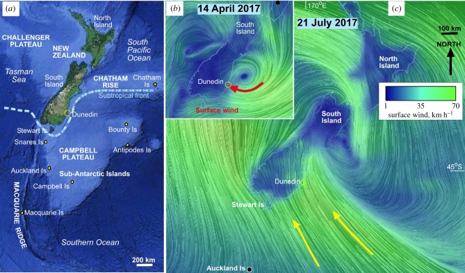
Southern New Zealand coastal waters are characterized by a strong northeasterly flow of coastal water [15] that facilitates a prevailing northward dispersal of buoyant biological material [16]. Offshore, the subtropical front (STF) [17–19] represents a marked transition from warm coastal waters to cool water of sub-Antarctic origin (figures 1a and 2a). This oceanographic feature runs sub-parallel to the continental shelf for several hundred kilometres, and generally represents a substantial barrier for biological dispersal (figure 1; [5,6,11]). However, recent analyses have suggested that strong wind events can disrupt prevailing oceanographic connectivity patterns [1], including promoting the dispersal of sub-Antarctic-origin material across the STF oceanographic barrier to make landfall on mainland NZ [5,6]. Until now, quantitative analyses of beach-cast material linked to such storms have been lacking.
Figure 1.
Topography and weather events in New Zealand and the Southern Ocean. (a) Onshore and offshore topography (from GoogleEarth) of the New Zealand crustal area and adjacent deep ocean. The STF oceanographic barrier represents the boundary between warm-temperate versus cold-sub-Antarctic water masses. (b) Easterly surface winds of Cyclone Cook on 14 April 2017, from earth.nullschool.net (adapted from [20]). (c) Surface wind model for the southerly storm of 21 July 2017. (Online version in colour.)
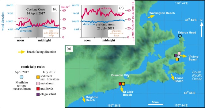
Figure 2.
Summary of extreme weather events and receiving beach geography in the Dunedin area, southern New Zealand. (a) Locations of beaches sampled for cast kelp rafts, and exotic rocks collected from holdfasts. (b) Easterly storm of Cyclone Cook, April 2017. (c) Southerly storm of July 2017. (Online version in colour.)
We here test our hypothesis that storms can alter marine dispersal patterns, via a comparative study made possible by two strong but contrasting storm events in southern New Zealand during 2017 (figures 1 and 2). First, the region was subjected to a sustained period of greater than 40 km h−1 easterly winds associated with Cyclone Cook in April 2017 (figures 1b and 3). Second, the same region experienced a period of sustained strong (greater than 60 km h−1) southerly winds in July 2017 (figures 1c and 3). Oceanographic and surface wind model data associated with these events are taken from earth.nullschool.net (figures 1 and 3). Both events drove substantial numbers of drifting kelp specimens ashore onto exposed beaches of southeastern New Zealand. By using a combination of oceanographic, genetic, geological and biological observations, we here reconstruct the travel history of these specimens, to test predictions about the role of wind in driving marine dispersal events across the major STF oceanographic barrier.
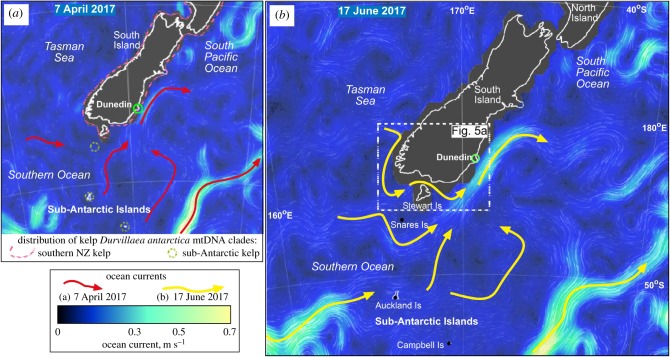
Figure 3.
Modelled ocean current directions and velocities (from earth.nullschool.net) for New Zealand and Southern Ocean on (a) 7 April 2017; and (b) 17 June 2017, while the kelp rafts described in this study were at sea. Regional distributions of genetically distinct D. antarctica kelp populations (adapted from [21]) are indicated in (a). Potential oceanographic connectivity between the Macquarie Island region and mainland NZ in July 2017 is indicated by a yellow arrow (bottom left of (b)). (Online version in colour.)
We predicted that:
(1) The stronger storm would be linked to longer dispersal distances, with more specimens traversing the STF to make landfall. Specifically, we hypothesized that the stronger and more sustained winds of July 2017 would drive a larger component of sub-Antarctic-origin specimens across the STF than the April 2017 event;
(2) Coastal geometry might interact with storm-forced dispersal to influence landfall of rafting specimens (see [8]). Specifically, we assessed whether beach orientation (e.g. east- versus south-facing) might be linked to the extent of offshore drift material driven onshore by these contrasting storms.
2. Material and methods
2.1. Coastal sampling
Specimens of beach-cast Durvillaea, associated epibiota and geological clasts were collected from four Dunedin beaches (Victory Beach, Allans Beach, St Clair and Brighton; table 1, figure 4) in the immediate aftermath of the April and July 2017 storms. Specifically, sampling was conducted within 6–24 h of the cessation of strong onshore winds—in the aftermath of the April and July 2017 storms. Sampled specimens were clearly identifiable as freshly beach-cast by the presence of live epifauna (including Lepas australis barnacles), and a lack of desiccation. To avoid beach-cast specimens of local origin (e.g. from the immediate headland), we sampled only kelp specimens covered in L. australis barnacles, a signature of substantial time adrift at sea. Ninety-five Durvillaea specimens were collected in April 2017 and 122 in July (table 1). In addition to samples of Durvillaea and L. australis, epifauna and holdfast rocks were also sampled if present. All specimens were stored in plastic bags and returned to the laboratory where they were stored frozen prior to analysis. The northeast-facing Warrington Beach (figure 2) was also examined after the July storm, and non-local beach-cast kelp was notably absent from this beach.
Table 1.
Summary of beach-cast Durvillaea sampling at four southern New Zealand beaches following April and July 2017 storm events. To avoid beach-cast material of local origin, sampling was restricted to specimens covered in L. australis barnacles. Sample sizes, numbers of specimens genetically assigned to each species/clade and mean (maximum) capitulum length of associated L. australis goose barnacles are indicated.
| beach—month (n) | location | D. poha | D. antarctica ‘NZ south’ | D. antarctica ‘subantarctic’ | Lepas (mm) |
|---|---|---|---|---|---|
| Victory—April (29) | 45°50′ S, 170°44′ E | 10 | 9 | 1 | 5.4 (10) |
| Victory—July (18) | 0 | 15 | 0 | 6.1 (11.2) | |
| Allans— April (29) | 45°52′ S, 170°42′ E | 10 | 14 | 1 | 5.2 (17.2) |
| Allans—July (33) | 5 | 24 | 3 | 10.0 (23.4) | |
| St Clair—April (14) | 45°54′ S, 170°30′ E | 6 | 5 | 0 | 3.0 (6.6) |
| St Clair—July (43) | 5 | 25 | 10 | 11.8 (30.8) | |
| Brighton—April (23) | 45°56′ S, 170°20′ E | 7 | 8 | 0 | 4.6 (11.9) |
| Brighton—July (28) | 11 | 15 | 1 | 6.5 (11.8) |
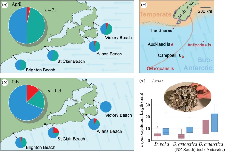
Figure 4.
Provenance of beach-cast kelp samples collected from Otago beaches in (a) April and (b) July 2017 (table 1) based on DNA sequencing. Sampling was restricted to specimens covered in L. australis barnacles, in order to avoid material of local origin. For (a) and (b), proportions of each haplogroup are shown in total in the large pie chart, and for each site in smaller pie charts, with blue representing D. antarctica haplotypes from southern New Zealand, green representing haplotypes of D. poha and red representing D. antarctica haplotypes previously only detected at sub-Antarctic locations. (c) Map showing distributions of D. antarctica haplogroups, with blue outline (South Island NZ and Stewart Island) representing the ‘NZSth’ haplogroup, and red outline representing the ‘Subant’ haplogroup. Sites in this region from which the ‘Subant1’ haplotype has previously been detected in attached populations are labelled in red text. The inferred dispersal from Macquarie Is across the STF barrier to southeastern New Zealand is indicated schematically by an orange arrow, and the prevailing wind direction in July 2017 storm event is shown by blue arrows. (d) Box and whisker plots of Lepas capitulum length on beach-cast kelp rafts in April (purple) and July (blue) for each haplogroup. A photo of large Lepas on one of the kelp holdfasts is shown (inset). (Online version in colour.)
2.2. Genetic analysis
For genetic analyses, DNA extraction, PCR and DNA sequencing of Durvillaea COI followed the methods of Fraser et al. [5], with new sequence data compared to the reference Durvillaea sequence database of Bussolini & Waters [21]. Durvillaea DNA sequence data were edited and aligned using Geneious 6.1.8, yielding a 629 bp alignment, with no indels detected. Sequences were assigned to reference haplotypes through UPGMA analysis using absolute distances, and assigned to previously described phylogeographic clades ([21]; figures 3a and 4c) through phylogenetic bootstrapping [22] using PAUP Version 4.0a152 [23].
2.3. Geological analysis
Rocks were found attached to holdfasts of 22 of the sampled (L. australis-covered) kelp specimens: 10 of the April 2017 specimens, and 12 of the July 2017 specimens. These rocks ranged in size from millimetre-scale veneers to greater than 7 kg. The mineral content, textures and rock identification were determined by standard petrographic microscopic observations, including polished thin sections. Distinctive rocks were the principal focus of this component of our study, and these were compared to the known regional geology of southern New Zealand and the sub-Aantarctic islands, to determine probable coastal source areas. Rock samples and sections are available by request from the Geology Department, University of Otago.
2.4. Lepas barnacle analysis
For each Durvillaea specimen collected, the size of encrusting barnacles (L. australis) was used as a proxy for rafting duration, based on L. australis growth rates reported by Skerman [24]. For each Durvillaea specimen, the three to four largest L. australis barnacle specimens were collected and returned to the laboratory where they were stored frozen prior to measurement. Barnacle capitulum length was measured using digital calipers. Rafting time was estimated using Fraser et al.'s [5] regression: y = 0.565x–4.0359 (where y = capitulum length and x = L. australis age). While the L. australis specimens sampled in the present study were collected several hundred kilometres south of the specimens measured by Skerman [24], in slightly cooler waters, the published growth rate estimates, nevertheless, present a useful tool for assessing relative ages of drifted specimens.
3. Results
3.1. Contrasting genetic composition of April versus July beach-cast kelp samples
Genetic analysis yielded 115 high-quality Durvillaea sequences for the July 2017 kelp samples (figure 4), of which 94 were D. antarctica (informative for discriminating mainland versus sub-Antarctic origins) whereas 21 were D. poha (uninformative as this species shows little geographical variation for COI [25]) (table 1). Likewise, April 2017 kelp samples yielded 71 high-quality Durvillaea sequences (figure 4), of which 38 were assignable to D. antarctica and 33 to D. poha (table 1). Phylogenetic analysis reliably assigned the vast majority of these Durvillaea sequences to known reference haplotypes [21] with the exception of nine samples from July 2017 assigned to a previously unrecorded haplotype ‘NZSth11’. Similarly, phylogenetic bootstrapping reliably assigned all sequences to previously documented Durvillaea clades/species from the southern NZ region: D. poha, D. antarctica ‘subantarctic’ and D. antarctica ‘NZ South’ (figure 4).
Genetic data revealed that the easterly storm of April 2017 led to the landfall of kelp specimens that were predominantly of southeastern NZ origin. Specifically, of the 38 D. antarctica specimens, 36 (95%) were genetically assigned to southern NZ (NZ-Sth) populations, whereas only 2 (5%) originated from the NZ sub-Antarctic (Auckland Islands or Snares). These rare sub-Antarctic specimens were detected only at the eastern-most beaches (Victory Beach, Allans Beach), relatively close to the STF (figure 4a). By contrast, the proportion of sub-Antarctic-origin specimens driven ashore by the July 2017 southerly storm was substantially larger (14 (15%) of 94 D. antactica sequenced) (table 1; figure 4), with most (10) of these sub-Antartic specimens carrying haplotype ‘Subant1’, a circumpolar lineage originating from relatively remote, high-latitude source populations.
These contrasting storm-driven landfall events are further emphasized by the size of L. australis barnacles associated with the July 2017 storm specimens, which were on average twice as large (mean 9.3 mm; max 30.8 mm) as those from the April 2017 storm samples (mean 4.7 mm; max 17.2 mm). The long rafting duration of the July 2017 sub-Antarctic-origin kelp specimens was further highlighted by the significantly larger (p = 0.01) L. australis specimens associated with them (mean 14.7 mm) relative to the NZ-origin specimens (mean 8.8 mm) from the same event (figure 4). On average, sub-Antarctic origin kelp specimens from the July storm event were estimated to have been at sea for at least 33 days, with some L. australis on sub-Antarctic specimens estimated to be at least 48 days old.
3.2. Contrasting geological origins of April versus July kelp-transported rocks
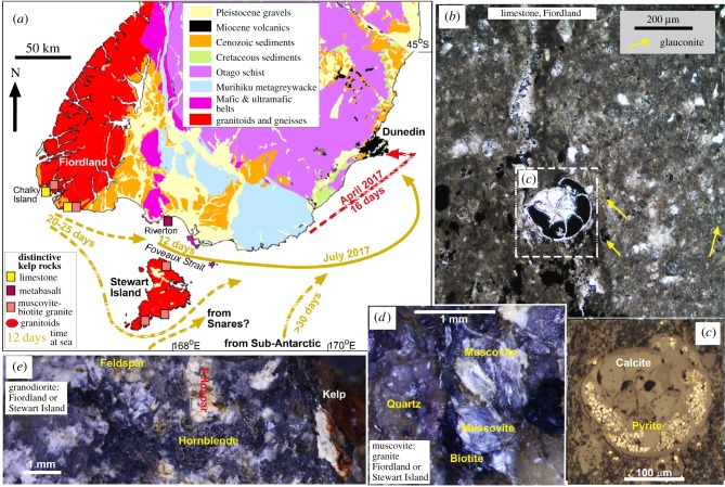
Rocks sourced from the relatively nearby Murihiku metagreywacke terrane (figure 5a; [20]) were the most far-travelled of the transported rocks found in the April 2017 storm. The largest of these rafted rocks weighed greater than 7 kg [20]. These April kelp-transported geological clasts were associated with relatively small dispersal distances (figure 5a; red-dashed line) and small Lepas barnacles (max 5 mm), indicating dispersal timeframes of approximately 2 weeks. By contrast, rocks collected from kelp beached in the July 2017 storm had been transported from much further afield. The longer dispersal timeframes are indicated by the finding that July geological clasts were associated with substantially larger Lepas barnacles (8.3–11.5 mm) than the April rock clasts (figure 5a).
Figure 5.
Geological controls on sources of kelp rafts on Dunedin beaches in the two 2017 weather events. (a) Geological map of southern New Zealand, showing inferred kelp rafting pathways, estimated transit times based on barnacle sizes and distinctive rock types that identify potential source areas. (b,c) Limestone bearing foramenifera from Chalky Island, Fiordland (d) Muscovite granite inferred to have been derived from Stewart Island or Fiordland. (e) Granodiorite derived from either Fiordland or Stewart Island. (Online version in colour.)
The most distinctive and distal of the July rocks was fine-grained chalky limestone with fossil foraminifera and authigenic minerals glauconite, pyrite and calcite (figure 5b,c). The only known coastal localities of this type of rock occur in SW South Island (figure 5a) and Campbell Island [26]. The limestone is unlikely to have come from the latter locality as the hosting kelp genetically matched the ‘NZSth’ mtDNA clade (whereas Campbell Island populations belong to the ‘Subant’ clade), and attached barnacles indicate a moderate drift time (figure 5a). Similarly, distinctive granitoid rocks (figure 5d,e) could have come only from Fiordland, Stewart Island or Snares Islands (figure 5a; [27,28]), in accord with the kelp genetics (NZSth) and moderate barnacle size.
Geological data similarly show a relatively strong southerly New Zealand component in the July storm samples (figure 5), with many ‘NZSth’ specimens showing geological origins consistent with Stewart Island and/or Fiordland origins (the remote south/southwest of NZ; figure 5), compared to the prevalence of clasts sourced from the relatively nearby Murihiku terrain (figure 5; [20]) in the April 2017 event.
3.3. Contrasting Lepas size associated with coastal geometry
Data from both storms suggest a possible interaction between coastal geometry and landfall of rafting specimens. Specifically, April 2017 (easterly storm) Lepas specimens on kelp collected from the single east-facing beach (mean 5.4 mm) were significantly (p = 0.03) larger than those on kelp collected from the three south-facing beaches (mean 4.5 mm). By contrast, these patterns were reversed in the southerly storm of July 2017, in which samples from south-facing beaches had substantially (p = 0.006) larger Lepas (mean 9.8 mm) than those from the sole east-facing beach (mean 6.3 mm).
4. Discussion
Rafting is thought to be an important ecological and evolutionary process for coastal ecosystems [4,5,29], yet relatively little is known about the effects of anomalous storm events on such passive marine dispersal. Our genetic analysis of approximately 200 beach-cast kelp specimens provides evidence of strongly contrasting dispersal and landfall patterns associated with distinct storm events in southern New Zealand. Specifically, while the easterly storm of April 2017 led to landfall of rafted material almost entirely of NZ mainland origin, the stronger southerly storm of July 2017 led to the landfall of more substantial numbers of sub-Antarctic specimens from across the STF oceanographic barrier (hypothesis 1; figure 4).
Many of the sub-Antarctic D. antarctica specimens that made landfall on mainland NZ (figure 4) during the July storm share a circumpolar sub-Antarctic haplotype ‘Subant1’ [30], which has previously been detected in just one of greater than 1000 beach-cast specimens from New Zealand analysed to date [21]. Although New Zealand sub-Antarctic (e.g. Auckland Islands) D. antarctica has previously been found washed ashore on mainland beaches [5,21], this study represents the first occasion on which substantial numbers of more remotely sourced rafts of southern sub-Antarctic origin (e.g. Macquarie Island) have been detected on the mainland. This ‘Subant1’ haplotype is widespread in the Southern Ocean, occurring at many sub-Antarctic islands and in southern Chile, but is absent from mainland New Zealand sites, and has previously only been detected on two island groups in the New Zealand/Australian sub-Antarctic region—the Antipodes Islands and Macquarie Island. Based on oceanographic models (figure 3; see also [15]), we suggest that Macquarie Island is a far more plausible source for these specimens than the Antipodes Islands (figure 4). The potential for dispersal of specimens from the Macquarie Island region (approximately 1200 km away) to southeastern NZ is further highlighted by strong NE flow-velocity in the oceanographic model for July 2017 (figure 3b—bottom left). Lepas goose-barnacle age estimates for these specimens suggest a substantial rafting duration, consistent with a distant origin such as Macquarie Island. Waters & Craw [20] recently estimated that rafting Durvillaea in southeastern New Zealand might travel approximately 10–15 km per day under prevailing weather conditions. Further south, research has calculated that drift surface material can travel faster, at up to 0.3 ms−1 (26 km per day) in the path of the Antarctic Circumpolar current [31], and at that speed the distance between Macquarie Island and southeastern New Zealand (figure 4) could comfortably be traversed within the at least 48-day estimated age of the largest Lepas found in this study (48 days at 0.3 ms−1 = 1244 km).
In the current study, we infer that the permeability of an oceanographic boundary (in this case the STF) is probably influenced by the extent, longevity and direction of a storm event (hypothesis 1). While southern New Zealand experienced two such storms in 2017, these events are comparatively rare (e.g. a few per decade), with equivalent storms having occurred, for instance, in February 2009 and May 2010 [5]. These data further highlight the capacity of strong storms [1], in addition to other major earth-history events (e.g. [32]), to disrupt prevailing oceanographic dispersal patterns and promote dispersal across oceanographic barriers. While the current study does not assess the direct ecological or population-genetic consequences of these particular storm-driven dispersal events, recent molecular studies have suggested that rafting across the STF may indeed occur with sufficient regularity to prevent substantial genetic divergence between some sub-Antarctic and mainland NZ epifaunal invertebrate populations [11]. When considering the biological consequences of particular rafting events, however, many factors should be considered. In addition to the reproductive status of beach-cast individuals [33], the numbers of specimens arriving simultaneously, and the site of landfall (e.g. rocky versus sandy shores; ecological and physiological constraints), the strength of high-density blocking (‘founder takes all’ [34]) presented by already-established coastal populations is likely to further constrain the colonization and/or geneflow outcomes of such dispersal events [30]. Indeed, the apparent failure of rafting sub-Antarctic D. antarctica lineages to successfully establish in mainland New Zealand likely reflects blocking by established dense Durvillaea populations [5,34].
On small geographical scales, these spatio-temporal data lend some support to the suggestion that coastal geometry may interact with meteorological and oceanographic conditions to influence landfall of passively drifting objects in the marine environment [7,8]. North-blown material, for instance, is apparently more likely to be intercepted by a south-facing beach. Our analysis of Lepas size and kelp-genetic data provide preliminary evidence for an association between beach orientation and the contrasting origins and composition of beach-cast material associated with distinct beaches and distinct storm events (figure 4). The suggested interaction between topography, oceanography and kelp-stranding dynamics, concurs with recent analyses of beach-cast Durvillaea in the southeastern Pacific [33].
In terms of geological dispersal driven by storm events, our combined analyses further indicate that substantial amounts of coastal geological material can be transported at sea by buoyant biological vectors [35]. These data, at the interface of biological and physical sciences, further highlight the potential for long-distance oceanic dispersal of rocks in the absence of sea ice [20].
Finally, we anticipate that increased focus on interactions between extreme weather events and oceanic dispersal will further enhance understanding of interactions between physical and biological processes in the marine environment.
Acknowledgements
We thank Mei Peng for fieldwork assistance. Chuck Landis, Jon Lindqvist and Andrew Allibone are thanked for discussions of potential rock sources. Chris Garden provided helpful discussions of the oceanographic processes addressed in the MS. The MS was substantially improved by constructive comments from two anonymous reviewers.
Data accessibility
The novel DNA sequence has been deposited in GenBank under accession no. MH002455. Nexus files, biological tissues and geological specimens are available from the authors by request.
Authors' contributions
J.W. and D.C. conceptualized the study; J.W. undertook fieldwork and D.C. conducted geological analyses. T.K. and J.W. undertook genetic analyses. J.W., D.C. and C.F. interpreted data, and D.C. and C.F. constructed figures. J.W. wrote a full draft of the paper. All authors contributed to editing of the manuscript and gave final approval for publication.
Competing interests
We declare we have no competing interests.
Funding
This work was supported by the University of Otago.
References
- 1.Monzón-Argüello C, Dell'Amico F, Morinière P, Marco A, López-Jurado LF, Hays GC, Scott R, Marsh R, Lee PLM. 2012. Lost at sea: genetic, oceanographic and meteorological evidence for storm-forced dispersal. J. R. Soc. Interface 9, 1725–1732. ( 10.1098/rsif.2011.0788) [DOI] [PMC free article] [PubMed] [Google Scholar]
- 2.Censky EJ, Hodge K, Dudley J. 1998. Over-water dispersal of lizards due to hurricanes. Nature 395, 556 ( 10.1038/26886) [DOI] [Google Scholar]
- 3.Ali JR, Huber M. 2010. Mammalian biodiversity on Madagascar controlled by ocean currents. Nature 463, 653–656. ( 10.1038/nature08706) [DOI] [PubMed] [Google Scholar]
- 4.Gillespie RG, Baldwin BG, Waters JM, Fraser CI, Nikula R, Roderick GK. 2012. Long-distance dispersal: a framework for hypothesis testing. Trends Ecol. Evol. 27, 47–56. ( 10.1016/j.tree.2011.08.009) [DOI] [PubMed] [Google Scholar]
- 5.Fraser CI, Nikula R, Waters JM. 2011. Oceanic rafting by a coastal community. Proc. R. Soc. B 278, 649–655. ( 10.1098/rspb.2010.1117) [DOI] [PMC free article] [PubMed] [Google Scholar]
- 6.Garden CJ, Currie K, Fraser CI, Waters JM. 2014. Rafting dispersal constrained by an oceanographic boundary. Mar. Ecol. Prog. Ser. 501, 297–302. ( 10.3354/meps10675) [DOI] [Google Scholar]
- 7.Archambault P, Bourget E. 1999. Influence of shoreline configuration on spatial variation of meroplanktonic larvae, recruitment and diversity of benthic subtidal communities. J. Exp. Mar. Biol. Ecol. 238, 161–184. ( 10.1016/S0022-0981(98)00146-4) [DOI] [Google Scholar]
- 8.Waters JM, Condie SA, Beheregaray LB. 2014. Does coastal topography constrain marine biogeography at an oceanographic interface? Mar. Freshw. Res. 65, 969–977. ( 10.1071/MF13307) [DOI] [Google Scholar]
- 9.Nikula R, Fraser CI, Spencer HG, Waters JM. 2010. Circumpolar dispersal by rafting in two subantarctic kelp-dwelling crustaceans. Mar. Ecol. Prog. Ser. 405, 221–230. ( 10.3354/meps08523) [DOI] [Google Scholar]
- 10.Nikula R, Spencer HG, Waters JM. 2011. Evolutionary consequences of microhabitat: population-genetic structuring in kelp- vs. rock-associated chitons. Mol. Ecol. 20, 4915–4924. ( 10.1111/j.1365-294X.2011.05332.x) [DOI] [PubMed] [Google Scholar]
- 11.Nikula R, Spencer HG, Waters JM. 2013. Passive rafting is a powerful driver of transoceanic gene flow. Biol. Lett. 9, 20120821 ( 10.1098/rsbl.2012.0821) [DOI] [PMC free article] [PubMed] [Google Scholar]
- 12.Cumming RA, Nikula R, Spencer HG, Waters JM. 2014. Transoceanic genetic similarities of kelp-associated sea slug populations: long-distance dispersal via rafting? J. Biogeogr. 41, 2357–2370. ( 10.1111/jbi.12376) [DOI] [Google Scholar]
- 13.Smith SDA. 2002. Kelp rafts in the Southern Ocean. Glob. Ecol. Biogeogr. 11, 67–69. ( 10.1046/j.1466-822X.2001.00259.x) [DOI] [Google Scholar]
- 14.Fraser CI, Kay GM, du Plessis M, Ryan PG. 2017. Breaking down the barrier: dispersal across the Antarctic Polar Front. Ecography 40, 235–237. ( 10.1111/ecog.02449) [DOI] [Google Scholar]
- 15.Chiswell SM. 2009. Colonisation and connectivity by intertidal limpets among New Zealand, Chatham and sub-Antarctic Islands. II. Oceanographic connections. Mar. Ecol.-Prog. Ser. 388, 121–135. ( 10.3354/Meps08167) [DOI] [Google Scholar]
- 16.Collins CJ, Fraser CI, Ashcroft A, Waters JM. 2010. Asymmetric dispersal of southern bull-kelp (Durvillaea antarctica) adults in coastal New Zealand: testing an oceanographic hypothesis. Mol. Ecol. 19, 4572–4580. ( 10.1111/j.1365-294X.2010.04842.x) [DOI] [PubMed] [Google Scholar]
- 17.Sutton PJH. 2003. The Southland Current: a subantarctic current. N. Z. J. Mar. Freshw. Res. 37, 645–652. ( 10.1080/00288330.2003.9517195) [DOI] [Google Scholar]
- 18.Smith RO, Vennell R, Bostock HC, Williams MJM. 2013. Interaction of the subtropical front with topography around southern New Zealand. Deep Sea Res. Part I 76, 13–26. ( 10.1016/j.dsr.2013.02.007) [DOI] [Google Scholar]
- 19.Chiswell SM, Bostock HC, Sutton PJH, Williams MJM. 2015. Physical oceanography of the deep seas around New Zealand: a review. N. Z. J. Mar. Freshw. Res. 49, 286–317. ( 10.1080/00288330.2014.992918) [DOI] [Google Scholar]
- 20.Waters JM, Craw D. 2017. Large kelp-rafted rocks as potential dropstones in the Southern Ocean. Mar. Geol. 391, 13–19. ( 10.1016/j.margeo.2017.07.016) [DOI] [Google Scholar]
- 21.Bussolini LT, Waters JM. 2015. Genetic analyses of rafted macroalgae reveal regional oceanographic connectivity patterns. J. Biogeogr. 42, 1319–1326. ( 10.1111/jbi.12491) [DOI] [Google Scholar]
- 22.Felsenstein J. 1985. Confidence limits on phylogenies—an approach using the bootstrap. Evolution 39, 783–791. ( 10.1111/j.1558-5646.1985.tb00420.x) [DOI] [PubMed] [Google Scholar]
- 23.Swofford DL. 2016. PAUP*. Phylogenetic analysis using parsimony (*and other methods). Version 4.0a157. Sunderland, MA: Sinauer Associates.
- 24.Skerman TM. 1958. Rates of growth in two species of Lepas (Cirripedia). New Zeal. J. Sci. 1, 402–411. [Google Scholar]
- 25.Fraser CI, Spencer HG, Waters JM. 2012. Durvillaea poha sp nov (Fucales, Phaeophyceae): a buoyant southern bull-kelp species endemic to New Zealand. Phycologia 51, 151–156. ( 10.2216/11-47.1) [DOI] [Google Scholar]
- 26.Beggs JM. 1978. Geology of the metamorphic basement and late Cretaceous Oligocene sedimentary sequence of Campbell Island, Southwest Pacific Ocean. J. R. Soc. N. Z. 8, 161–177. ( 10.1080/03036758.1978.10429389) [DOI] [Google Scholar]
- 27.Turnbull IM, Allibone AH. 2003. Geology of the Murihiku area. Institute of geological & nuclear sciences 1:250 000 geological Map 20. Lower Hutt, New Zealand: Institute of Geological & Nuclear Sciences Ltd. [Google Scholar]
- 28.Scott JM, Turnbull IM, Sagar MW, Tulloch AJ, Waight TE, Palin JM. 2015. Geology and geochronology of the Sub-Antarctic Snares Islands/Tini Heke, New Zealand. New Zeal. J. Geol. Geop. 58, 202–212. ( 10.1080/00288306.2015.1023810) [DOI] [Google Scholar]
- 29.Muhlin JF, Engel CR, Stessel R, Weatherbee RA, Brawley SH. 2008. The influence of coastal topography, circulation patterns, and rafting in structuring populations of an intertidal alga. Mol. Ecol. 17, 1198–1210. ( 10.1111/j.1365-294X.2007.03624.x) [DOI] [PubMed] [Google Scholar]
- 30.Fraser CI, Nikula R, Spencer HG, Waters JM. 2009. Kelp genes reveal effects of subantarctic sea ice during the Last Glacial Maximum. Proc. Natl Acad. Sci. USA 106, 3249–3253. ( 10.1073/pnas.0810635106) [DOI] [PMC free article] [PubMed] [Google Scholar]
- 31.Coombs DS, Landis CA. 1966. Pumice from South Sandwich eruption of March 1962 reaches New Zealand. Nature 209, 289–290. ( 10.1038/209289b0) [DOI] [Google Scholar]
- 32.Carlton JT, Chapman JW, Geller JB, Miller JA, Carlton DA, McCuller MI, Treneman NC, Steves BP, Ruiz GM. 2017. Tsunami-driven rafting: transoceanic species dispersal and implications for marine biogeography. Science 357, 1402–1406. ( 10.1126/science.aao1498) [DOI] [PubMed] [Google Scholar]
- 33.López BA, Macaya EC, Tala F, Tellier F, Thiel M. 2017. The variable routes of rafting: stranding dynamics of floating bull kelp Durvillaea antarctica (Fucales, Phaeophyceae) on beaches in the SE Pacific. J. Phycol. 53, 70–84. ( 10.1111/jpy.12479) [DOI] [PubMed] [Google Scholar]
- 34.Waters JM, Fraser CI, Hewitt GM. 2013. Founder takes all: density-dependent processes structure biodiversity. Trends Ecol. Evol. 28, 78–85. ( 10.1016/j.tree.2012.08.024) [DOI] [PubMed] [Google Scholar]
- 35.Garden CJ, Smith AM. 2015. Voyages of seaweeds: the role of macroalgae in sediment transport. Sediment. Geol. 318, 1–9. ( 10.1016/j.sedgeo.2014.11.007) [DOI] [Google Scholar]
Associated Data
This section collects any data citations, data availability statements, or supplementary materials included in this article.
Data Availability Statement
The novel DNA sequence has been deposited in GenBank under accession no. MH002455. Nexus files, biological tissues and geological specimens are available from the authors by request.


