Abstract
Since the 1950s river networks have been intensely researched in geosciences and hydrology. This led to the definition of scaling laws that described the organisation of landscapes under fluvial incision and were later explored by statistical physics and fractal mathematics. The emblematic Hack’s Law proposes a power-law relationship between watershed area and main stream length. Though extensively documented, a wide range of values is still reported for Hack’s parameters. Some authors associate this dispersion to local geologic and climatic conditions. Here based on the analysis of large sets of river basins in various climatic and geological settings, we confirm the geometric similarity of river networks. We demonstrate that basin shape is mostly related to Hack’s coefficient and not to the exponent, independently of external forcing such as lithology and pluviometry.
River networks worldwide follow the emblematic Hack’s Law, which expresses the length of a stream as a function of its watershed area. Here the authors show this law does not depend on lithology or rainfall, but on the shape of watersheds and confirms the self-similarity of river networks.
Introduction
Since the mid-twentieth century, geomorphologists have discovered empirical laws suggesting the existence of invariant properties that describe landscape evolution1–4. One of the best-known scaling laws of river network is Hack’s Law, which states that the length L of the longest channel of a river basin, measured from outlet to drainage divide, scales with the area A of this basin. This law is written as a power function:
| 1 |
where c and n are often referred to as Hack’s coefficient and exponent, respectively.
Many approaches5–8 including self-affine, energy dissipation or percolation theories focused on the significance of n and its relationship with stream networks fractal dimension, river sinuosity or basin elongation. In contrast, Hack’s coefficient has rarely been studied9 and its significance remains enigmatic.
In his original paper on river catchments in Midwestern United States1, Hack found that for drainage areas inferior to 100 km2, n = 0.6 but can be as large as 0.7 in some regions, whereas c ~ 1.5 but ranges between 1.1 and 2.7 (for L and A expressed in km and km2, respectively). He also interpreted this exponent greater than 0.5 as the result of an increase in basin elongation with the increasing catchment area.
Since this pioneering study, Hack’s parameters have been estimated in a variety of contexts. Based on a study of 250 randomly selected worldwide basins with an area ranging from 0.25 to 7,800,000 km2, Mueller found that the length–area relationship is best fitted using n = 0.5510. Furthermore, he proposed that n is not a constant, but rather decreases when basin area increases. He suggested that the value of 0.6 obtained by Hack is only relevant for small (<20,000 km2) catchments and an exponent of 0.46 is more suitable for large basins. From an extensive study based on datasets spanning eleven orders of magnitude in basin area, this last conclusion is questioned by Montgomery and Dietrich11. They obtained Hack’s coefficient and exponent of 2.02 and 0.49 (for L and A expressed in km and km2, respectively), regardless of the catchment size, suggesting a geometric similarity of the drainage network. More recent estimates12–15 based on regional studies give n and c between 0.45 and 0.7 and 1 and 6, respectively. This wide range of values may be partly due to the spread within dataset or to local variations in climatic or geological properties. It can also be related either to various methods assuming different definitions for L or to the use of a non-homogeneous dataset, which combines stream channels and basins either manually digitised from topographic maps or automatically extracted from digital elevation models (DEM).
While the significance of the exponent n has been the focus of numerous studies, the significance of Hack’s coefficient has seldom been addressed and remains an open question. Here, we re-evaluate these two coefficients using a consistent processing of DEM data in various settings, which include mountain ranges and plains as well as semi-arid to humid climates. We specifically focus on the role of the basin shape on Hack’s parameters using refinements of established methods. We analyse the morphology of drainage basins in the Bhutan Himalaya, where climate and geology are well established16–18 and show how the size and the geometry of river drainages influence c and n. We propose that Hack’s coefficient is only controlled by the basin shape, whereas Hack’s exponent depends neither on basin area nor on basin elongation. The comparison with other regions underlines the universal character of these findings11 and confirms the geometric similarity of rivers network, regardless of lithology, uplift or rainfall.
Results
Basins shape gives a physical meaning to data dispersion
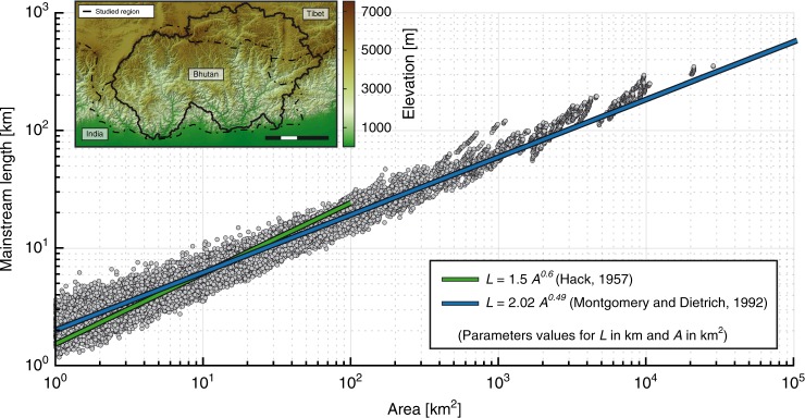
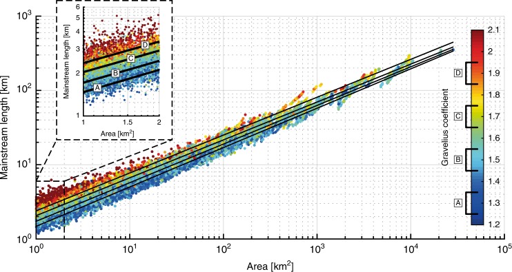
The relationship between L and A we obtain from ca. 22,000 basins from the Bhutan Himalaya is consistent with commonly reported Hack’s parameters2,11 (Fig. 1). Note that for a given basin area the obtained L can vary in a ratio of one to three. This data dispersion—though present in all previous studies—is seldom discussed2,10–12,14. The use of Gravelius compactness coefficient19 (GC) (Fig. 2) to define measures of catchment shape reveals that this dispersion is indeed not related to data precision but rather to basin shape (Fig. 3). In addition, it appears that an increase in basin elongation (increased GC) does not correlate with an increase in catchment area. Whatever the spatial scale considered, catchments exhibit a wide range of shapes with GC ranging between 1.2 and 2.1. In agreement with Montgomery and Dietrich11, and contrary to Muller’s conclusions10 this suggests that basin elongation is not related to basin size.
Fig. 1.
‘Length–Area’ dataset from ca. 22,000 river basins (grey circles) in Bhutan Himalaya. Green and blue lines show the original Hack’s law2 and the law proposed by Montgomery and Dietrich11, respectively. Inset shows topographic map of Bhutan region with the limits of the studied region. Scale bar: 100 km
Fig. 2.
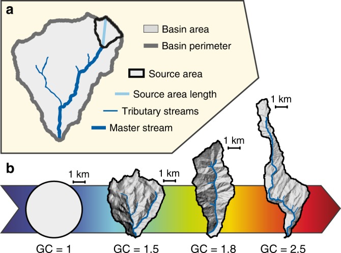
Geometric parameters of a drainage network and its watershed basin. a Main drainage basin features used in this study. b Selected basin shapes from the Bhutan dataset and associated Gravelius coefficients for a constant basin area (ca. 17.5 km²) compared to a perfectly circular basin (GC=1). For each basin, the thick blue line corresponds to the longest stream that defines L
Fig. 3.
‘Length–Area’ dataset from ca. 22,000 river basins in Bhutan Himalaya as a function of basin shape. Colour code is for the Gravelius compacity coefficient19 (GC, see Fig. 2). Inset is a blow-up for basins between 1 and 2 km². Black lines a–d represent the best fit obtained for subsets based on class intervals of GC [1.25–1.35], [1.45–1.55], [1.65–1.75] and [1.85–195], respectively
Hack’s coefficient is related to basin shape
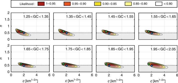
Although basin shape varies as a continuum, we divide drainage basins into eight GC class intervals to better assess how this parameter controls c and n, from mostly circular (GC = 1.3) to very elongated (GC = 2.0). Except for a few studies2,13, Hack’s parameters are often reported without error bars. Conversely to these traditional approaches focused on the assessment of the best-fitting model, here we favour the use of a likelihood function, which provides information on both robustness and trade-off of these two parameters. Unsurprisingly, the higher the exponent, the lower the coefficient (Fig. 4). The obtained maximum likelihood is in good agreement with parameters reported by Montgomery and Dietrich11. Furthermore, the consistency with c and n values proposed by Hack2 depends on GC. For median values of GC (<1.6) representing about 75% of basins, c and n are in good agreement with Hack’s original findings, contrary to what is observed for more elongated basins (GC > 1.6). Considering 95% likelihood to define error bars, our results suggest that n is constant between 0.50 and 0.57 and is independent of the basin shape (Fig. 5a). In contrast, we show that c is clearly influenced by the basin shape with a relationship between c and GC (Fig. 5b). Virtually, this coefficient corresponds to the mainstream length L = c for a basin of 1 km² (see inset Fig. 3). For the simple case of a rectangular-shaped basin with two sides a and b, the relationship between c and GC can be obtained directly from the basin area A and perimeter P:
| 2 |
yielding two solutions: ,
Fig. 4.
Likelihood contour plot of Hack’s parameters for eight classes of GC. Colour scale gives the likelihood obtained for each pair of parameters. Green and blue diamond show c coefficient and n exponent as defined by Hack2 (c ~ 15; n = 0.6) and Montgomery and Dietrich11 (c = 2.02; n = 0.49), respectively. Grey zones correspond to the parameters space that does not satisfy Euclidean geometry and is discarded from our analysis
Fig. 5.
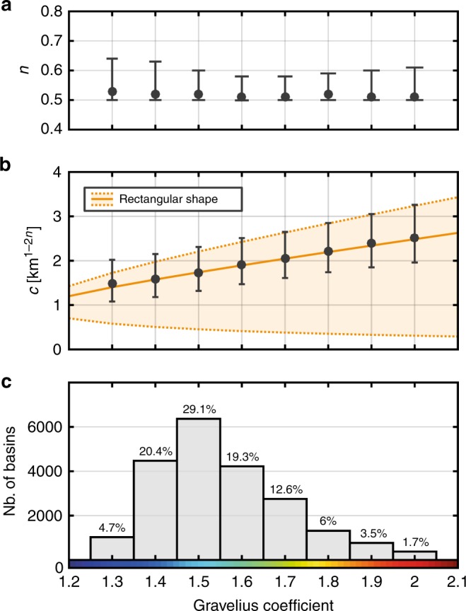
Hack’s Law parameters vs. Gravelius compacity coefficient. a, b Exponent (n) and coefficient (c) for the eight interval classes of GC showed in Fig. 2. Error bars are defined considering the 95% likelihood contour obtained for each class. Orange solid line corresponds to the relation obtained from Eq. (4). Orange dotted lines represent the lower and upper bounds for the Hack’s coefficient assuming a simple rectangular basin. c Number of basins for each class of GC and its associated proportion within the dataset
Since GC is a not sensitive to the basin orientation with respect to the drainage network, these two solutions represent the upper and lower bounds for the c coefficient (Fig. 5b). Here, the obtained c–GC relationship suggests that c is mostly related to rectangle length:
| 3 |
Discussion
There is still some debate on how external conditions influence c and n. Several studies consider that local conditions associated with lithologic properties, tectonic movements, glaciations and eustatism exert a strong control on the main features of drainage basins2,12,20 while climatic conditions exert a lower influence21. Conversely, the results obtained by Montgomery and Dietrich11 reveal the ubiquitous character of Hack’s exponent. In addition, thermodynamic modelling22 suggests that external properties have only minor effect on the drainage network because of the small scale of channel initiation compared to the size of geologic domains.
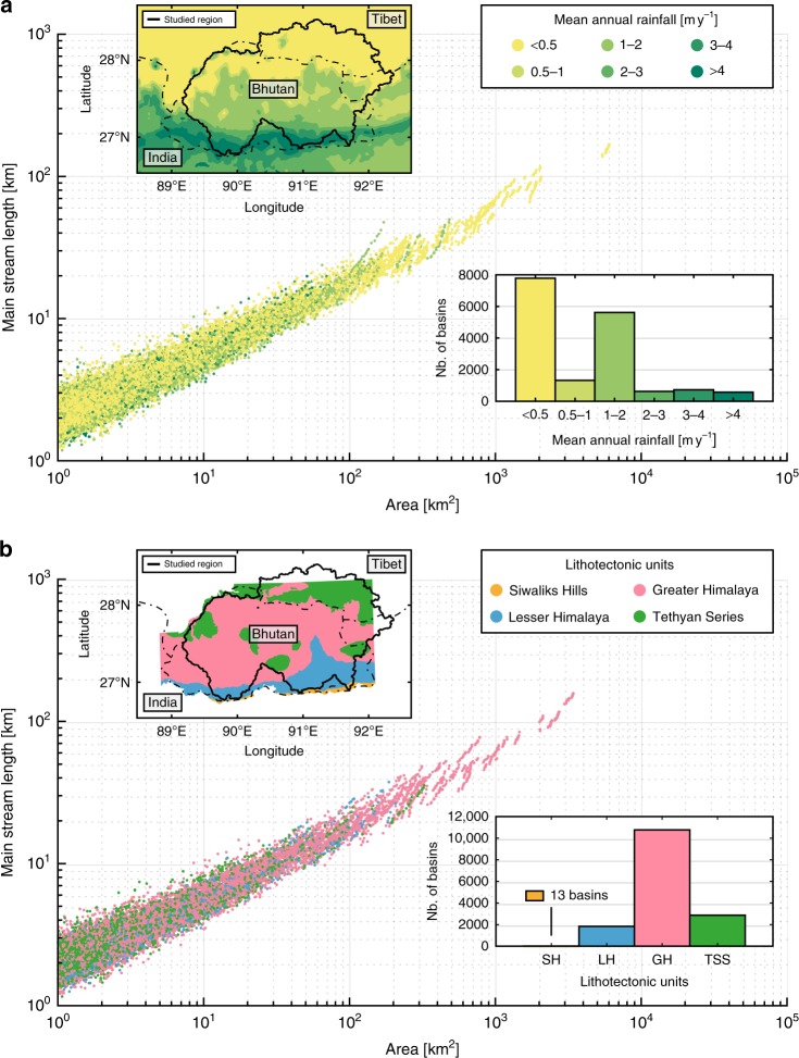
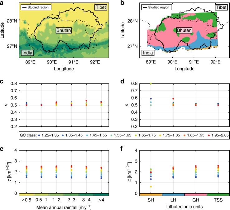
The rainfall distribution in the study area exhibits considerable north–south variations from 0.2 m yr−1 in Tibet to 6 m yr−1 at the Himalayan front16 (Fig. 6a). We divide our basin dataset into six rainfall classes from dry (<0.5 m yr−1) to very humid (>4 m yr−1) following common practice for the Himalayas16 and limit our analysis to basins characterised by a single rainfall class to avoid spatial variations that may affect results for large catchments (Fig. 6a). To maintain consistency with our approach, we divide each of the six rainfall classes into eight sub-classes based on GC values (as in Fig. 5). For a given GC class, we observe that both estimated n exponent and c coefficient are independent of the mean annual precipitation (Fig. 7d, f) and conclude that mean annual rainfall does not play a significant role on Hack’s Law.
Fig. 6.
Length–area relationship to mean annual rainfall and lithology. a Scatter plot of the main stream length with respect to the basin size. Colour scale indicates the annual rate of precipitation for each basin. Inserts are a map of the six main annual rainfall classes16 and a histogram showing the distribution of basins with respect to these classes. b Scatter plot of the main stream length with respect to the basin size. Colour gives the geological domain for each basin. Inserts are a map of the four major litho-tectonic units in Bhutan17 and a histogram showing the distribution of basins with respect to these units
Fig. 7.
Rainfall and lithological effects on Hack’s parameters for different classes of basin shapes. a, b Maps of the six main rainfall classes16 and the four major geological units in Bhutan17. c–f Influence of rainfall (c, e) and lithology (d, f) on Hack’s exponent (c, d) and coefficient (e, f). Colours of dots indicate the GC class as shown in Fig. 1. Geological units are: Siwalik Hills (SH), Lesser Himalayas (LH), Greater Himalayas (GH) and Tethyan Sedimentary Series (TSS). Hack’s exponent shows dispersion of GC values within a given rainfall or lithology class but remains generally constant. Hack’s coefficient remains constant for a given GC class regardless of rainfall or lithology. The SH lithology class displays very strong dispersion associated with a scarce dataset (13 basins) and is discarded from our analysis
Similarly, Bhutan can be divided into four distinct major litho-tectonic units encountered along the whole Himalayan arc, which include from north to south: sediments and low-grade metamorphic rocks of the Tethyan Sedimentary Series, high-grade metamorphic rocks of the Greater Himalaya, low-grade metasediments of the Lesser Himalaya and quaternary clastic sediments of the Siwaliks Hills (Fig. 6b). Although these units exhibit significantly different surface erodibility values23, it appears that their lithologic properties have no major influence on Hack’s parameters, regardless of the associated GC class (Fig. 7d, f). The Siwaliks Hills domain crops out along a very narrow strip (<10 km width) along the Himalayan Front in Bhutan and contains only 13 mono-lithology basins (Fig. 6b). Thereby, the strong variability obtained for that litho-tectonic class is not statistically robust and is ignored in our analysis.
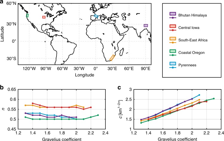
To illustrate our approach, we analysed ca. 22,000 sub-basins from four major trans-Himalayan basins and obtain results mostly relevant to these local river networks. To extend the scope of our findings to a wider range of climatic and geologic settings, four additional regions are studied following the same methodology. They include the Pyrenees Ranges to compare with another active belt and South-East Africa, Iowa and coastal Oregon, for which Hack’s parameters have been already reported12,14. As expected, each area displays its own characteristics with specific c and n parameters (Fig. 8). Note that Hack’s parameters for the Pyrenees are very similar to those obtained for Bhutan (c ~ 1.5−2.5 and n ~ 0.5). Basins from Coastal Oregon have n ~ 0.5 identical to exponents obtained in active mountain belts, but with a slightly lower coefficient (1.3–2.2 vs. 1.5–2.5). These results, though significantly different from previously reported parameters (n = 0.7 and c = 1.2)12, are derived from a significantly larger dataset (ca. 21,000 vs. 20 basins) and are statistically more robust. This finding leads to a fractal dimension D = 2n = 1 for channel length5 and questions the fractal character of river networks in orogenic zones24. This may suggest a similarity of river networks in these specific settings, in spite of very different rainfall and uplift rates.
Fig. 8.
Synthesis of results obtained for our global comparison. a Map showing the location of the five studied region. b, c For all regions, Hack’s exponent n (shape-independent) and coefficient c (shape-dependent) exhibit similar trends with respect to the Gravelius Compacity coefficient
Compared to Bhutan, basins from Iowa and South-East Africa exhibit higher exponents and lower coefficients. These results are consistent with previous studies12,14 and suggest a different behaviour for low-relief landscapes. Despite these differences, the comparison with other regions confirms the main findings obtained in the Bhutan area. Indeed, basins for all study areas present common significant features, such as a constant Hack’s exponent with respect to GC and a basin shape-dependent Hack’s coefficient.
The consistency of our results across such very different settings indicates that river basins reach a shape that appears to be unrelated to external influences such as lithology, tectonic uplift or rainfall distribution. Together, these results lead us to confirm the geometric similarity of river networks with basin size-independent Hack’s parameters11. Our findings reveal that basin shape gives a physical meaning to the data dispersion observed in previously published L–A data sets. This parameter needs to be considered in Hack’s Law to better describe the main stream length–area relationship. We hence propose a modification of Hack’s law (given by Eq. (1)):
| 4 |
where n is a constant, ranging between 0.5 and 0.6, and c is a coefficient, which depends on the basin shape φ (for this study, the Gravelius Compacity coefficient).
In summary, when applied to five selected regions of low to high relief, our analysis shows that auto-similarity is confirmed for mountainous areas, and that both c coefficient and n exponent are independent of lithology and rainfall, and finally that Hack’s coefficient is related to basin shape.
Methods
Data and study areas
The topographic dataset used in this study is the 30-m-resolution ALOS—World 3D graciously provided by JAXA. The standard deviation of elevation is estimated to be 5 m25, which can be considered as negligible with respect to the scale of morphometric properties analysed in this study.
Overall, we applied our approach to five regions in order to provide a wide range of both climatic and geologic settings (Supplementary Fig. 1–5). Areas are chosen for their well-established geology and rates of tectonic activity.
The Bhutan Himalaya is located in the eastern part of the Himalayan arc. This active mountain belt area presents several specific features such as high tectonic uplift (up to 1 cm. yr−1) and high mean annual rainfall (up to 6 m. yr−1) concentrated during the monsoon period. In this study, we consider four distinct tectonic units, which include from north to south, (1) the Tethyan Sedimentary series, (2) the Greater Himalaya, (3) the Lesser Himalaya and (4) the Siwaliks. Here we processed ca. 22,000 sub-basins contained within four major trans-Himalayan basins of the Wang Chhu, Puna Tsang Chhu, Manas Chhu and Bada Chhu.
The Pyrenees are a low tectonic activity mountain range that exhibits moderate rainfall. Its axial zone consists in metamorphic rocks of the Hercynian basement. Results are based on the analysis of ca. 8,500 basins.
The Oregon Coastal Range is an active belt resulting from the subduction of the Juan de Fuca plate. There is no evidence of glaciers during the last glaciation in this region12. The lithology is composed of slightly deformed clastic sediments and volcanic rocks. Climate is maritime with an average annual rainfall in the range of 2.5 m yr−1. ca. 21,000 basins are used here.
South-East Africa coast is a passive margin formed 140 Ma ago during the Gondwana break-up. Lithology consists mostly in sedimentary rocks (sandstone, shale and till). The region knows a humid sub-tropical climate with annual rainfall up to 1 m yr−1 around Durban. Its drainage network from the coast to the base of the Drakensberg escarpment has probably not changed over the last 10 million years14. Here we used ca. 45,000 basins.
Central Iowa is a tectonically stable continental region, whose plains landscapes were shaped by the last glaciation. Thus lithology is associated with thick layers of glacial and inter-glacial deposits of till, loess and alluvium. Climate is continental with seasonal moderate rainfall. It is suggested that rivers still are in a post-glaciation process of development and basins are not fully evolved yet12. About 17,500 basins are studied in this area.
Main stream length
We used TopoToolbox26,27 to derive basins and channel networks from the DEM data. Using flow path computation, stream network is extracted assuming a threshold value of 1 km2 source area, which physically represents a transition from steep debris flow-dominated channels to lower-gradient alluvial channels28. Sub-basins are defined at each confluence in the drainage network. This results in a great number of sampled basins (several tens of thousands) with a wide size range.
There are many ways of defining the longest stream. The length L is here measured for each basin along the longest valley from the outlet to the divide following the original Hack’s method2, which includes not only the channel length, but also the longest horizontal distance between the location of the stream source and the drainage divide of the source area (Fig. 2a). This prevents problems associated with the definition of channel head position.
Basin shape
The shape of a drainage basin is commonly characterised with a dimensionless index, expressed as the ratio between two dimensions of the considered basin. Many indices have been proposed, including the shape factor1, the elongation ratio29, the circularity ratio30 or the aspect ratio9. Here we use the Gravelius compactness coefficient GC19, which is one of the most widely accepted shape indices. It is defined as the ratio between the basin perimeter and the circumference of a circle with a surface equal to the basin area. This coefficient is 1 for an ideally circular watershed and increases with both basin elongation and irregularity of basin boundaries (Fig. 2b). Easy to calculate, GC is well-suited for quantifying the shape of natural drainage catchments, especially for basins with a non-rectangular shape.
The main disadvantage of GC comes from the fractal character of the basin perimeter that causes GC to depend on the DEM resolution. This fractal characteristic also implies an overestimated GC for larger basins due to the presence of small-scale crenulation31. To solve both of these issues, we assume that the basin perimeter has to be measured with a relative resolution set by:
| 5 |
where A is the area of the basin calculated from the 30-m-resolution DEM31. Finally, GC is defined by the equation:
| 6 |
where Pr and Ar are the perimeter and the area of the basin as calculated with the relative resolution Rr. In that way, GC does not depend anymore on either DEM resolution nor basin scale and becomes a robust shape factor to compare basins across different scales (Supplementary Fig. 6). We also test the effect of DEM resolution between 30 m and 90 m in our results (Supplementary Fig. 7).
Error bars
Here, to assess both uncertainties and possible trade-off between Hack’s parameters, we calculate for each GC class interval and for n ranging between 0.5—as expected from Euclidean geometry—and 2, and c ranging between 0 and 6, the likelihood function:
| 7 |
where k is the number of basins, and Lobs and Lcalc are the observed and the calculated longest channel, respectively.
Electronic supplementary material
Acknowledgements
T.S.-S.’s Ph.D. is supported by a fellowship from the French Ministry for Higher Education and Research. We thank Wolfgang Schwanghart for providing the programme TopoToolBox to analyse Digital Elevation Models and JAXA for providing the ALOS World 3D data. Authors acknowledge valuable input from two anonymous referees.
Author contributions
R.C. and M.F. initiated this study. T.S.-S. performed the topographic analyses. All authors contributed to the writing of the paper.
Data availability
The data that support the findings of this sudy are available from the corresponding author on request.
Competing interests
The authors declare no competing interests.
Footnotes
Publisher's note: Springer Nature remains neutral with regard to jurisdictional claims in published maps and institutional affiliations.
Electronic supplementary material
Supplementary Information accompanies this paper at 10.1038/s41467-018-06210-4.
References
- 1.Horton RE. Erosional development of streams and their drainage basins: hydrophysical approach to quantitative morphology. Bull. Geol. Soc. Am. 1945;5:275–370. doi: 10.1130/0016-7606(1945)56[275:EDOSAT]2.0.CO;2. [DOI] [Google Scholar]
- 2.Hack, J. T. Studies of longitudinal stream profiles in Virginia and Maryland. US Geological Survey Professional PaperB294, 1-97 (1957).
- 3.Shreve RL. Statistical law of stream numbers. J. Geol. 1966;74:17–37. doi: 10.1086/627137. [DOI] [Google Scholar]
- 4.Tokunaga E. The composition of drainage network in Toyohira river basin and valuation of Horton’s first law. Geophys. Bull. Hokkaido Univ. 1966;15:1–19. [Google Scholar]
- 5.Mandelbrot, B.B. The Fractal Geometry of Nature, Vol. 173 (WH freeman, New York, NY, 1983).
- 6.Maritan A, Rinaldo A, Rigon R, Giacometti A, Rodriguez-Iturbe I. Scaling laws for river networks. Am. Phys. Soc. 1996;53:1510–1516. doi: 10.1103/physreve.53.1510. [DOI] [PubMed] [Google Scholar]
- 7.Rigon R, Rodriguez-Iturbe I, Rinaldo A. Feasible optimality implies Hack’s law. Water Resour. Res. 1998;34:3181–3189. doi: 10.1029/98WR02287. [DOI] [Google Scholar]
- 8.Hunt AG. Brief communication: possible explanation of the values of Hack’s drainage basin, river length scaling exponent. Nonlinear Process. Geophys. 2016;23:91–93. doi: 10.5194/npg-23-91-2016. [DOI] [Google Scholar]
- 9.Castelltort S, Simpson G, Darrioulat A. Slope control on the aspect ratio of river basins. Terra Nova. 2009;21:265–270. doi: 10.1111/j.1365-3121.2009.00880.x. [DOI] [Google Scholar]
- 10.Mueller JE. Re-evaluation of the relationship of master streams and drainage basins. Bull. Geol. Soc. Am. 1972;83:3471–3474. doi: 10.1130/0016-7606(1972)83[3471:ROTROM]2.0.CO;2. [DOI] [Google Scholar]
- 11.Montgomery DR, Dietrich WE. Channel Initiation and the problem of landscape scale. Science. 1992;255:826–830. doi: 10.1126/science.255.5046.826. [DOI] [PubMed] [Google Scholar]
- 12.Willemin JH. 2000. Hack’s law, sinuosity, convexity, elongation. Water Resour. Res. 2000;36:3365–3374. doi: 10.1029/2000WR900229. [DOI] [Google Scholar]
- 13.Dodds PS, Rothman DH. Scaling, universality, and geomorphology. Annu. Rev. Earth Planet. Sci. 2000;28:571–610. doi: 10.1146/annurev.earth.28.1.571. [DOI] [Google Scholar]
- 14.Walcott RC, Summerfield MA. Universality and variability in basin outlet spacing: implications for the two-dimensional form of drainage basins. Basin Res. 2009;21:147–155. doi: 10.1111/j.1365-2117.2008.00379.x. [DOI] [Google Scholar]
- 15.Shen X, Anagnostou EN, Mei Y, et Hong Y. Data descriptor: a global distributed basin morphometric dataset. Nat. Sci. Data. 2017;4:Article number: 160124. doi: 10.1038/sdata.2016.124. [DOI] [PMC free article] [PubMed] [Google Scholar]
- 16.Bookhagen B, Burbank DW. Toward a complete Himalayan hydrological budget: spatiotemporal distribution of snowmelt and rainfall and their impact on river discharge. J. Geophys. Res. 2010;115:F03019. doi: 10.1029/2009JF001426. [DOI] [Google Scholar]
- 17.Long S, McQuarrie N, Tobgay T, Grudjic D, Hollister L. Geological map of Bhutan. J. Maps. 2011;7:184–192. doi: 10.4113/jom.2011.1159. [DOI] [Google Scholar]
- 18.Coutand. I. Geometry and kinematics of the main himalayan thrust and neogene crustal exhumation in the Bhutanese Himalaya derived from inversion of multithermochronologic data. J. Geophys. Res.: Solid Earth. 2014;119:1446–1481. doi: 10.1002/2013JB010891. [DOI] [Google Scholar]
- 19.Gravelius, H. Flusskunde1 (1914).
- 20.Mosley MP, Parker RS. Re-evaluation of the relationship of master streams and drainage basins: discussion. Bull. Geol. Soc. Am. 1973;84:3123–3126. doi: 10.1130/0016-7606(1973)84<3123:ROTROM>2.0.CO;2. [DOI] [Google Scholar]
- 21.Mantilla, R., Troutman, B.M. and Gupta, V.K. Testing self-similarity in the topology of river networks. J. Geophys. Res.: Earth Surface115, F03038 (2010).
- 22.Rinaldo A, Rodriguez-Iturbe I, Rigon R. Channel networks. Annu. Rev. Earth Planet. Sci. 1998;26:289–327. doi: 10.1146/annurev.earth.26.1.289. [DOI] [Google Scholar]
- 23.Attal M, Lavé J. Changes of bedload characteristics along Marsyandi river (central Nepal): implications for understanding hillslope sediment supply, sediment load evolution along fluvial networks, and denudation in active orogenic belts. Geol. Soc. Am. Spec. Pap. 2006;398:143–171. [Google Scholar]
- 24.Beauvais AA, Montgomery DR. Are channel networks statistically self-similar? Geology. 1997;25:1063–1066. doi: 10.1130/0091-7613(1997)025<1063:ACNSSS>2.3.CO;2. [DOI] [Google Scholar]
- 25.Takaku J, Tadono T, Tsutsui K, Ichikawa M. Validation of ‘AW3D’ global DSM generated from ALOS PRISM. ISPRS Ann. Photogramm., Remote Sens. Spat. Inf. Sci. 2016;4:12–19. [Google Scholar]
- 26.Schwanghart W, Kuhn NJ. TopoToolbox: a set of Matlab functions for topographic analysis. Environ. Model. Softw. 2010;25:770–781. doi: 10.1016/j.envsoft.2009.12.002. [DOI] [Google Scholar]
- 27.Schwanghart W, Scherler D. TopoToolbox 2 – MATLAB-based software for topographic analysis and modeling in Earth surface sciences. Earth Surf. Dyn. 2014;2:1–7. doi: 10.5194/esurf-2-1-2014. [DOI] [Google Scholar]
- 28.Montgomery DR, Foufoula-Georgiou E. Channel source representation using digital elevation models. Water Resour. Res. 1993;29:3925–3934. doi: 10.1029/93WR02463. [DOI] [Google Scholar]
- 29.Schumm SA. Evaluation of drainage systems and slopes in badlands at Perth Amboy, New Jersey. Bull. Geol. Soc. Am. 1956;67:597–646. doi: 10.1130/0016-7606(1956)67[597:EODSAS]2.0.CO;2. [DOI] [Google Scholar]
- 30.Strahler, A. N. in Handbook of applied hydrology (ed Chow, V. T.) Ch. 4 (McGraw-Hill: New York, NY, 1964). .
- 31.Breyer SP, Snow RS. Drainage basin perimeters: a fractal significance. Geomorphology. 1992;5:143–157. doi: 10.1016/0169-555X(92)90062-S. [DOI] [Google Scholar]
Associated Data
This section collects any data citations, data availability statements, or supplementary materials included in this article.
Supplementary Materials
Data Availability Statement
The data that support the findings of this sudy are available from the corresponding author on request.


