Abstract
Many urban areas affected by flood disasters are also becoming increasingly ecologically and socially fragmented due to the accumulation of vacant properties. While redevelopment is often viewed as the primary objective in regenerating vacant properties, they can also potentially provide ecological and hydrological land uses. Rather than chasing development- based incentives for regenerating vacant lots in high flood-risk communities, a balance should be sought between new developmental land uses and green infrastructure to help counteract stormwater runoff and flood effects, or “Resilience through Regeneration.” This paper uses landscape performance measures to evaluate the economic and hydrologic performance of green infrastructure regeneration projects for three marginalized neighborhoods in Houston, Texas, USA. Each project site is characterized by excessive vacant lots and flood issues. Results suggest that, when using green infrastructure to regenerate vacant properties, 1) flood risk continually decreases, 2) upfront economic costs increase in the short term (when compared to conventional development), and 3) the long-term economic return on investment is much higher.
Keywords: Urban Regeneration, Community Resilience, Landscape Performance, Green Infrastructure
1. Introduction
1.1. The Growing Issue of Vacant Urban Land
Vacant land is a ubiquitous urban phenomenon [1]. A small number of vacant parcels can be an indicator of economic growth (typically characteristic of populating cities), while larger proportions of vacant area typically indicate urban decline (typically characteristic of depopulating cities) [2]. Historically, the term “vacant land” has carried a negative connotation, and is often referred to alongside research on urban decay. The vacancy condition has grown to the extent that scholars and designers have now developed an agenda to begin to regenerate such properties through both temporary and permanent uses.
Nearly 17% of each large U.S. city’s land area is considered vacant, with an average of 4% of city structures unoccupied [3]. Disinvestment, suburbanization, and annexation are reported as the primary causes of increases in vacant land, while growing local economies, population immigration, and city policies tend to help reduce the amount of vacant land [4]. The ratio of vacant land to city size has increased by 1.3% since 1998, indicating a growing problem [3]. While regional variations exist in both the amount and type of urban vacancies, many vacant parcels are small, odd- shaped, and disconnected, making them difficult to regenerate or repurpose.
1.2. Flood Disasters and Vacant Land
Disaster events can exacerbate the vacancy condition, resulting in massive increases in vacant parcels and abandoned structures until recovery can occur. The Texas coast is one of the most frequently impacted areas by coastal storms globally. Houston in Texas, is one of the fastest growing U.S. cities, and has one of the highest numbers of flood-related fatalities in the past 50 years [5]. Despite its fast development, Houston reports nearly 11% of its land as vacant [6] (Fig. 1). Many vacant properties in Houston are peripheral greenfields which have been annexed for future development, while the non-greenfield ones are mostly concentrated in marginalized communities, which are also typically characterized as highly vulnerable to flooding [7][8]. Vacant land, however, does not always need to be viewed as a problem and, if managed or repurposed correctly, can contribute to flood resilience. Vacant land can present valuable opportunities for urban transformations as well as a potential solution to the flooding issues.
Figure 1.
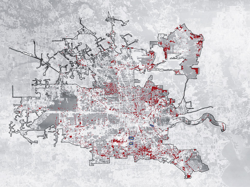
Vacant land in Houston in 2017 and locations of three case sites (© Zhu Rui)
1.3. Vacant Land as Pores - A Prototype for the Sponge City
Despite the challenges associated with the flood vulnerability, social conditions and disconnected typology of urban vacant land, careful research and design efforts toward regenerating vacant land prove to be a huge opportunity for cities. The idea of “Sponge City” has raised attention to adaptive water management as a critical part of urban planning and policy-making [9][10]. For a sponge to absorb and hold water, the composition of numerous small pores is essential. For cities that have been built based on traditional grey infrastructure to get water off site as soon as possible, siting and implementing these pores are often difficult without impeding the economic, social and other functions [11][12]. Therefore, for existing cities that are either growing or shrinking, urban vacant land regeneration presents great suitability and feasibility to serve as the pores to enhance the water adaptivity of cities. Rather than creating conflicting environmental and economic objectives, as is noted with literature outlining the challenges of Sponge City, transforming vacant land offers unprecedented opportunities for ecosystem services, as well as a variety of economic and social co-benefits [13][14].
2. Research Objectives and Design Process
2.1. Objectives
“Resilience through Regeneration” refers to a design approach which seeks to mitigate community-scaled flood effects through repurposing efforts of vacant properties around green infrastructure (GI). Using this approach, this research examines the economic costs and benefits of retrofitting GI into community growth plans as a strategy for vacant land regeneration. The paper describes three design projects in Houston, which utilize the “Resilience through Regeneration” approach: South Park, Manchester, and Sunnyside. Each neighborhood is characterized by flood issues and elevated proportions of vacant land. Within each, a master plan which retrofits vacant lots and proposes new development and GI is developed by our team from Department of Landscape Architecture and Urban Planning, Texas A&M University. Each plan was created following a participatory design approach which utilized feedback loops between university personnel and community members to assist in design decision making. Then, we evaluated and compared the economic return and hydrologic benefits of each design. These plans have been given to the communities and local planning agencies and are being used to develop official construction documents for portions of each plan.
2.2. Performance Assessment
The performance evaluation process utilizes consistent landscape performance tools to capture the hydrologic and economic performance of the three master plans. The Landscape Architecture Foundation (LAF) has developed and recommended a series of landscape performance tools to measure the effectiveness with which existing or designed / planned solutions fulfill their intended purpose [15]. The LAF’s Toolkit offers a broad range of calculators to analyze social, hydrologic, and economic performance of designs and plans. Economic rationale of GI is emerging as an essential component of flood provision strategies [16]. As one of the tools included in the LAF’s Toolkit, the Center for Neighborhood Technology’s (CNT) National Stormwater Management Calculator, also known as the National Green Values Calculator (GVC), is an interactive tool for comparing the performance, costs, and benefits of GI to conventional stormwater practices. This tool has been used to assist in assessing the effectiveness of stormwater management practices on water quality [17] and flood proofing [18], predicting runoff capture [19], and evaluating stormwater runoff storage [20].The strengths of this calculator include its ability to be applied at the community scale, its emphasis on the performance of GI, and its integration of datasets regarding local storm events and other conditions. Through 1) determining the average precipitation of the site under investigation, 2) selecting a stormwater runoff volume reduction goal, 3) defining the impervious areas under development with no GI, and 4) inputting the types of GI utilized within the site plan, the GVC can be used to determine the cost-efficiency of runoff volume reduction. The GVC offers a range of GI facilities to be chosen from including green roofs, planter boxes, rain gardens, cisterns / rain barrels, native vegetation, filter strips, amended soil, roadside swales, trees, parking lot swales, and permeable pavement. In this research, the GVC was used to compare costs, benefits, and performance of GI compared to conventional stormwater management practices [21]. And the performance evaluation included the land cover change, the increased amount of green space for utilitarian and recreational purposes, the amount of stormwater retention, and economic benefits. The economic benefits are evaluated based on stormwater retention, carbon dioxide sequestration, reduced air pollutants, compensatory value of trees, groundwater replenishment, reduced energy use, and reduced treatment costs.
2.3. Vacant Land Drivers and Selection
For this research, identical definitions of vacant land were used by all sites under investigation. Vacant land data was obtained by the Houston-Galveston Area Council Land Use Portal [22]; it defines vacant land as “land which was cleared but had no current land use.” Vacant parcels were coded as a separate land use within the dataset. Defined as still largely vegetated with no major apparent alterations, “undeveloped land” was also differentiated from “vacant land” within the dataset. Lands with lower development potential were listed as “vacant” while others were listed as “undeveloped,” making vacant land prime parcels for non-developmental repurposing through means such as GI. However, we also included some developmental program on selected vacant lands because each of these neighborhoods was considered underserved and / or marginalized, and it was important to try to increase their local economy, job opportunities, and social cohesion.
Because the same dataset was used to map all vacant lands across all three neighborhoods and the same tool (GVC) was used to measure landscape performance of each master plan, valid conclusions and comparisons across all projects can be made to generalize the potential effects of the “resilience through regeneration” approach. Purposeful efforts were made to 1) utilize the same definition and inventory method for vacant properties, 2) utilize similar design processes and equivalent engagement procedures, and 3) utilize the same performance assessment methodology to increase the generalizability of conclusions.
3. Design and Evaluation Outcomes
3.1. South Park, TX
3.1.1. Background
South Park is located in southern Houston along Clear Creek which connects to the Gulf of Mexico Ship Channel and makes it highly vulnerable to flood-related disasters. However, most of the floodings in South Park during Hurricane Harvey occurred because of ineffective and outdated open ditch drainage infrastructure, not from overtopping from the bayou. High vacancy rate has been a long-term problem in South Park, despite intense population growth in Houston. While the vacancy rate of Houston decreased from 20% to 11% from 2006 to 2017, the South Park community maintained a vacancy rate near 16%. Currently, a majority of lots have remained vacant for more than 3 years within the neighborhood. The land value in this neighborhood is 82% lower than the Houston average and 61% lower than Houston median (Fig. 2).
Figure 2.
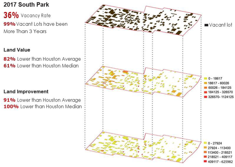
Vacant land conditions within the design site in South Park (© Zhu Rui)
3.1.2. Master Plan
The design retrofits vacant land and proposes a majority of new development along the major arterial as well as larger-scaled community parks, to spur future economic growth (Fig. 3). Diverse housing types including townhouses, apartments, and affordable single family are dispersed throughout the residential areas. New functions such as live-work houses, a family center, and religious structures along secondary arterials are also proposed. Two-sided sidewalks and community gardens increase outdoor recreational opportunities for community members. In order to efficiently reduce the impact of floods, several bio- swales are built to enhance the inadequate open ditch system and convey stormwater from the most flood-vulnerable areas to two existing detention ponds. Several low impact bio-swales and rain gardens are integrated within severe flood-areas to promote infiltration and evapotranspiration. Improvements and connections are made for all designed bio-swales, rain gardens, open ditches, detention areas, and sewers to create an interconnected stormwater management system.
Figure 3.
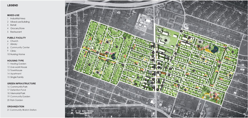
Master plan for South Park (© Zhu Rui)
3.1.3. Projected Performance
According to the GVC, 85% of the site’s existing vacant lots will be regenerated and 90% of existing abandoned structures will be refurbished, redeveloped, or demolished. Fifteen percent of the vacant properties will be regenerated into GI. Seventeen acres of new GI will protect residents and properties and provide both ecological and economic benefits. The GVC shows that, compared with conventional approaches, this design increases the site’s permeable area by 15% and captures more than 45% of the runoff volume. Simultaneously, the design can capture about 65.7 million ft3 of runoff, creating over 2.6 million dollars in annual green benefits (Fig. 4).
Figure 4.
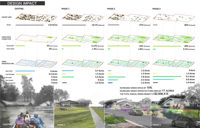
Projected performance summary of the master plan for South Park (©Zhu Rui)
3.2. Manchester, TX
3.2.1. Background
Manchester is located in southeast of Houston, surrounded by industries, and has one of the highest river impairments and lowest water qualities in the state. It is also one of the most flood-prone neighborhoods in the U.S. Local authorities provide sightseeing ventures named “Toxic Tours” for visitors and residents to raise awareness of the serious flooding and pollution conditions in the neighborhood [23]. The site is composed of 16% vacant parcels / abandoned structures; 68% of the neighborhood’s surface is currently impervious. A significant lack of open space makes the current infrastructure ineffective in preventing flooding caused by both frequent and intense storms.
3.2.2. Master Plan
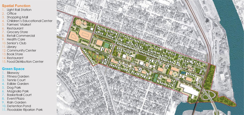
According to the design (Fig. 5), most of the vacant properties are repurposed as GI. Based on community feedback, new functionality of green spaces includes event space, recreational opportunities, edible gardens, and parks along with a mixture of stormwater management facilities. Each residential block was incorporated with its own fitness garden, which is retrofitted from existing vacant parcels. To satisfy the demand of various age groups, more community support services are also designed into the vision, including a community center, a children’s center, a senior club, health care facilities, a bookstore, and a library. The market and community center are two anchors to spur development, generate local business revenue, increase activities in the neighborhood, and strengthen residents’ sense of belonging to the community. Event spaces and the community center provide a site for residents to hold their traditional cultural celebrations / festivals while a popup market allows for selling local crafts and goods. A proposed food distribution center will connect local farmers with grocery stores and food markets, as well as offer nutrition assistance to disadvantaged households. Streetscape improvements and new stormwater mitigation facilities are proposed to counteract effects of any proposed development. Because the flow paths and ponding areas of stormwater are primarily located on the streets, streetscape amenities to deal with flooding issues are of primary concern. A series of low impact stormwater mitigation techniques are proposed along the roadways to help the current insufficient gutters and sewers collect stormwater. Curb cuts are also strategically located to direct the water to bio-swales along the streets. Excess rain water that cannot be collected is directed into the other proposed facilities as parts of a flood attenuation system. And designed rain gardens can serve as green space for residents in dry times.
Figure 5.
Master plan for Manchester (© Galen Newman)
3.2.3. Projected Performance
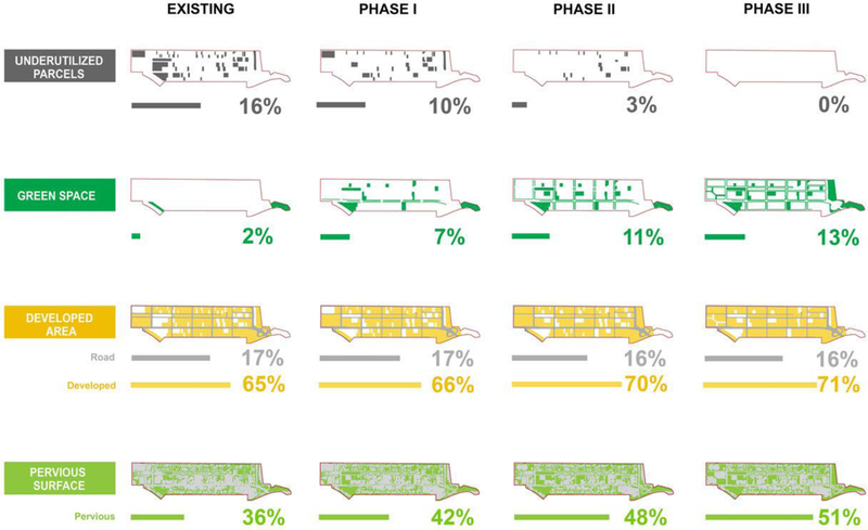
After the design is implemented, a majority of the existing underutilized parcels will be regenerated. Simultaneously, the amount of green space increases to nearly 7 times of its current amount while the percentage of pervious surface increases from 36% to 51% (Fig. 6). This change will strengthen the capability of water infiltration. According to the GVC, over 40 million gallons of stormwater can be retained annually, with over 5 million dollars of annual green benefits are generated from the multi-functional GI.
Figure 6.
Projected performance summary of the master plan for Manchester (© Galen Newman)
3.3. Sunnyside, TX
3.3.1. Background
Sunnyside is a marginalized and flood-prone super- neighborhood in south Houston, TX which is located tangent to South Park. Due to outdated and ineffective infrastructure, Sunnyside is severely impacted by large rainfall events and a majority of the floods were due to the inability of the open ditch system to provide adequate drainage. Four major issues affect Sunnyside: floodwaters, excessive vacant land, physical inactivity, and a lack of ecological infrastructure. The top five reasons these issues exist, as proclaimed by residents, were due to low housing conditions (9%), infrastructure inadequacies (31%), lack of maintenance (26%), security and crime concerns (22%), and local economic downturns (12%). Fifty percent of the design site is within the 100-year floodplain. It was noted by residents that in order to avoid flooding, new construction in the site is built at a higher elevation, which leads to new and increased flooding issues for existing housing. Due to the inadequate open ditch system and a lack of effective GI, many of the stormwater ponds are along the roads and within single- family residences.
3.3.2. Master Plan
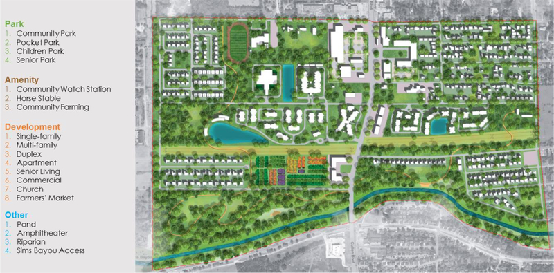
The master plan (Fig. 7) proposes a GI system that will help mitigate the impact of future severe rainfall events. The system is formed through an interconnected network of bio-swales, rain gardens, detention ponds, retention ponds, riparian corridors, and parking lot renovations. Most of the existing vacant lots will be repurposed as GI in stormwater ponding areas, due to the current low development potential for high probability of flood damage, the relatively low land value, the lack of jobs, and high poverty. All newly proposed pocket parks on site will serve as flood attenuation pockets. In the single-family districts where identified standing water exists, a system of rain gardens is proposed. Outdoor structures store stormwater during flood events while bio-swales within backyards of single-family homes distribute stormwater to the existing open ditch and sewer system.
Figure 7.
Master plan for Sunnyside (© Ren Dingding)
Four existing detention ponds are also improved through the design. Recreation decks along detention ponds increase physical activity time, while proposed GI facilities tangent to these ponds capture spillover during future flood events. A proposed religious structure also serves as a flood shelter during disaster events. The bio-swale system helps to capture stormwater exceeding current capacities and distribute it into the current system. The commercial center with large exposed permeable parking lot is also a good opportunity for stormwater management where excess impervious surfaces exist.
3.3.3. Projected Performance
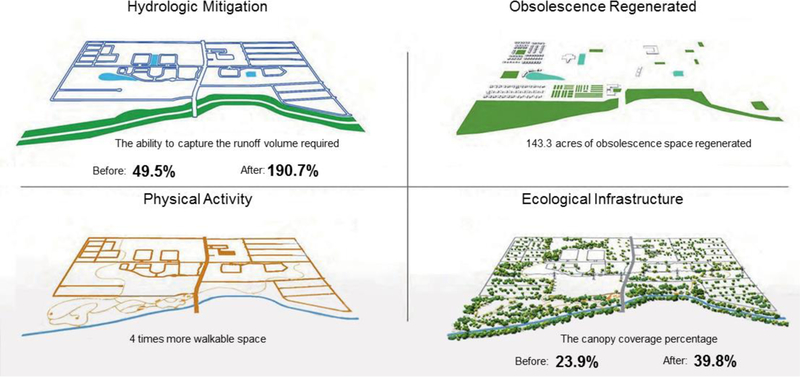
The GVC was used to calculate the runoff volume captured in pre and post scenarios as well as the overall benefits to the community. Overall, the ability of the proposed design to capture runoff volume increased from 49.6% to 190.7%. One-hundred and forty-three acres of vacant space will be regenerated, four times more walkable space will be created, and dense canopy coverage increases from 23.9% to 39.8% (Fig. 8).
Figure 8.
Projected performance summary of the master plan for Sunnyside (© Ren Dingding)
4. Discussion and Conclusions
This research examined the hydrological and economic effects of GI as a strategy for vacant land regeneration. Three design projects were carried out independently in three underserved neighborhoods in Houston, following a “Resilience through Regeneration” approach. This approach incorporates both public engagement and site-specific programming. For the landscape performance evaluation, we applied the GVC to the three master plans to assess the impacts.
Although the three projects focused on the same “Resilience through Regeneration” framework, they diverged in terms of the critical problems related to vacant land and the solutions to the problems. However, consistent patterns were revealed from comparing the impacts of the three projects calculated by the GVC and shown in Tables 1–3.
Table 1:
GI Types and Their Average Costs Used in Three Case Sites
| South Park | Manchester | Sunnyside | |||||||
|---|---|---|---|---|---|---|---|---|---|
| GI Type | Construction Costs (USD) |
Annual Maintenance Costs (USD) | Total 100-Year Life Cycle Costs (USD) |
Construction Costs (USD) |
Annual Maintenance Costs (USD) |
Total 100-Year Life Cycle Costs (USD) |
Construction Costs (USD) |
Annual Maintenance Costs (USD) |
Total 100-Year Life Cycle Costs (USD) |
| Green Roof | --- | --- | --- | 63,000 | 150 | 79,859 | 323,678 | 514 | 410,294 |
| Native Plants | 909,108 | 34,570 | 5,510,911 | --- | --- | --- | 81,729 | 6,864 | 29,867,697 |
| Rain Garden | 2,493,960 | 51,135 | 6,874,389 | 7,000,112 | 41,147 | 15,918,221 | 709,618 | 32,467 | 2,956,002 |
| Permeable Pavement | --- | --- | --- | --- | --- | --- | 213,017 | 880 | 390,046 |
| Swales in Parking Lots | --- | --- | --- | --- | --- | --- | 157,500 | 4,260 | 381,652 |
| Rain Water Harvesting | --- | --- | --- | 410 | 14 | 1,041 | --- | --- | --- |
| Trees | 2,532,000 | 40,000 | 3,748,082 | --- | --- | --- | --- | --- | --- |
| Tree Box Filters | 19,444,160 | 52,320 | 26,537,918 | --- | --- | --- | --- | --- | --- |
| Roadside Swales | 495,300 | 2,072 | 328,700 | 1,053,145 | 3,361 | 2,567,969 | 4,566,180 | 50,944 | 7,928,579 |
Table 3.
GI Performance and Return on Investment of Three Case Sites
| South Park | Manchester | Sunnyside | |
|---|---|---|---|
| Vacant Land Decrease | 85% | 100% | 100% |
| Green Space Increase | 15% | 8% | 11% |
| Annual Stormwater Retention | 73,806 m2 19,497,528 gal |
25,512 m2 6,739,497 gal |
152,899 m2 40,391,716 gal |
| GI Construction Cost | USD 29,874,528 | USD 6,501,722 | USD 8,116,667 |
| GI Annual Maintenance Cost | USD 180,097 | USD 95,929 | USD 44,672 |
| GI Life Cycle Cost | USD 43,000,000 | USD 41,934,270 | USD 18,567,090 |
| Total Annual Green Benefits | USD 2,606,415 | USD 1,099,719 | USD 5,053,001 |
| Life Cycle Green Benefits | USD 60,020,100 | USD 87,150,810 | USD 116,359,684 |
| Return on Investment Time | 70 years | 30 years | 20 years |
First, our strategy to regenerate vacant properties is more easily performed because of less developmental expenses. In fact, 95% of pre-design vacant lands were regenerated, on average across all three sites. Because a large proportion of the repurposed vacant properties were not based on developmental pursuits but GI, we could still transform the lands of GI into development lands in the future if needed. The green spaces can provide temporary or permanent functions to assist with social or hydrological needs. These newly created nodes will spur diverse interaction and networks of people, resources, and activities, which will potentially contribute to urban vitality and land use optimization.
Second, this increase in green space significantly assists in stormwater retention. Across all sites, the plans called for an average of over 11% of increase in green space. This results in over 22.2 million gallons of stormwater retained annually, which equals approximately 40% of the storage capacity of one of Houston’s two major reservoirs, Addicks Reservoir [24].
Third, the economic benefits created by this increase in green space and GI over a 100-year life cycle greatly outweigh the upfront construction and maintenance costs. With an average total cost (including construction and maintenance) of 34.5 million dollars but an 87.8 million dollar economic benefit across all three sites. These benefits generally take around 40 years to produce a return on investment. Construction costs appear to claim a bulk of the overall cost total, green roofs have the highest overall costs (about USD 250 / m3) to construct while rain gardens provide the most benefits for the least cost (about USD 180 / m3).
In many cases, upfront costs are extremely high, so marginalized communities will need to seek additional funding and phase in such projects. However, this research shows that when using GI to assist in regenerating vacant properties, upfront economic costs increase in the short term while the long-term return on investment is much higher. It should be noted that this total cost-benefit comparison, however, does not include jobs created, local economy increases, social and public health savings, and savings from flood recovery costs. Although these benefits are not immediately capitalized, they are likely to serve as catalysts for growth and sustainability of the city.
Fourth, although all three designs explore the strategy of regenerating vacant land with GI and stormwater management, they propose different strategies for regeneration, based on the pre-design vacant land conditions and design priorities identified by residents. Future designers can draw lessons from the three prototypes. The South Park design represents a solution for an inland neighborhood that faces severe challenges in high percentages of vacant land (more than 35%); The Manchester design demonstrates a solution for a riverfront neighborhood that is impacted by flooding and low physical and mental health; And the Sunnyside design provides an example for a neighborhood that has an outdated open ditch drainage system, which caused inland flooding during excessive rainfall.
As one of the first attempts to apply and evaluate the Sponge City principles as incremental strategies in existing cities, these projects demonstrated the prototype of utilizing and repurposing vacant land as the pores within the Sponge City. Based on the improved hydrological and economic performance across three different projects, it is indicated that these prototypes have the potential to be applied in cities that face similar challenges in increased vacancy rate and flood hazard.
Table 2.
GI Benefits in Three Case Sites
| South Park | Manchester | Sunnyside | ||||
|---|---|---|---|---|---|---|
| GI Benefits | Annual Benefits (USD) | 100-Year Life Cycle Benefits (USD) |
Annual Benefits (USD) | 100-Year Life Cycle Benefits (USD) |
Annual Benefits (USD) | 100-Year Life Cycle Benefits (USD) |
| Reduced Air Pollutants | 1,448 | 35,201 | --- | --- | --- | --- |
| Reduced Treatment Benefits | 80,787 | 1,629,625 | 2,071,085 | 65,402,290 | 60,646 | 19,050,168 |
| Reduced Energy Use | --- | --- | 1,323,885 | 40,597,038 | 1,036,103 | 40,008,531 |
| Carbon Dioxide Sequestration | 960 | 30,420 | --- | --- | --- | --- |
| Compensatory Value of Trees | 1,913,000 | 48,212,702 | --- | --- | --- | --- |
| Groundwater Replenishment | 610,220 | 10,112,152 | 1,729,116 | 10,360,356 | 2,970 | 28,092,111 |
Acknowledgments
The authors would like to thank the Institute for Sustainable Communities, The Hazard Reduction and Recovery Center, and the Center for Housing and Urban Development at Texas A&M University for their support on this research.
Research Funding: Superfund Research Program of National Institute of Environmental Health Sciences of the National Institutes of Health of America (No. P42ES027704).
References
- [1].Pagano M, & Bowman A (2000). Vacant land in cities: An urban resource. Brookings Institution, Center on Urban and Metropolitan Policy Retrieved from https://www.brookings.edu/wp-content/uploads/2016/06/paganofinal.pdf
- [2].Hollander JB (2010). Moving toward a shrinking cities metric: Analyzing land use changes associated with depopulation in Flint, Michigan. Cityscape, 12, 133–151. [Google Scholar]
- [3].Newman G, Bowman AO, Lee RJ, & Kim B (2016). A current inventory of vacant urban land in America. Journal of Urban Design, 21(3), 302–319. doi: 10.1080/13574809.2016.1167589 [DOI] [Google Scholar]
- [4].Newman G, Hollander JB, Lee J, Gu D, Kim B, Lee RJ, …, & Li YX (2018). Smarter shrinkage: A neighborhood-scaled rightsizing strategy based on land use dynamics. Journal of Geovisualization and Spatial Analysis, 2(11): in-press. doi: 10.1007/s41651-018-0018-6 [DOI] [Google Scholar]
- [5].Highfield WE, Norman SA and Brody SD, 2013. Examining the 100‐year floodplain as a metric of risk, loss, and household adjustment. Risk Analysis: An International Journal, 33(2), 186–191. [DOI] [PubMed] [Google Scholar]
- [6].Newman G, Brody SD, & Smith AL (2017). Repurposing vacant land through landscape connectivity. Landscape Journal, 36(1), 37–57. doi: 10.3368/lj.36.1.37 [DOI] [PMC free article] [PubMed] [Google Scholar]
- [7].Sohn W, Kim J-H, & Newman G (2014). A BLUEprint for Stormwater Infrastructure Design: Implementation and Efficacy of LID. Landscape Research Record, 2(1), 50–61. Retrieved from https://www.thecela.org/pdfs/LRR%20No.%2002.pdf [Google Scholar]
- [8].Berke P, Newman G, Lee J, Combs T, Kolosna C, & Salvesen D (2015). Evaluation of networks of plans and vulnerability to hazards and climate change: A resilience scorecard. Journal of the American Planning Association, 81(4), 287–302. doi: 10.1080/01944363.2015.1093954 [DOI] [Google Scholar]
- [9].Chan FKS, Griffiths JA, Higgitt D, Xu SY, Zhu FF, Tang YT, & Thorne CR (2018). “Sponge City” in China - A breakthrough of planning and flood risk management in the urban context. Land Use Policy, 76, 772–778. doi: 10.1016/j.landusepol.2018.03.005 [DOI] [Google Scholar]
- [10].Yu KJ (2016). Ecology-based water management: “Sponge City” and “Sponge Land”. Frontiers, (21), 6–18. doi: 10.16619/j.cnki.rmltxsqy.2016.21.001 [DOI] [Google Scholar]
- [11].Brody SD, & Highfield WE (2013). Open space protection and flood mitigation: A national study. Land use policy, (32), 89–95. [Google Scholar]
- [12].Kabisch N (2015). Ecosystem service implementation and governance challenges in urban green space planning - The case of Berlin, Germany. Land Use Policy, (42), 557–567. [Google Scholar]
- [13].Newman G, Lee J, & Berke P (2016). Using the land transformation model to forecast vacant land. Journal of Land Use Science, 11(4), 450–475. [Google Scholar]
- [14].Xia J, Zhang YY, Xiong LH, He S, Wang LF, & Yu ZB (2017). Opportunities and challenges of the Sponge City construction related to urban water issues in China. Science China Earth Sciences, 60(4), 652–658. [Google Scholar]
- [15].Yang B, Li SJ, & Binder C (2016). A research frontier in landscape architecture: landscape performance and assessment of social benefits. Landscape Research, 41(3), 314–329. doi: 10.1080/01426397.2015.1077944 [DOI] [Google Scholar]
- [16].Jayasooriya VM, & Ng AWM (2014). Tools for modeling of stormwater management and economics of green infrastructure practices: A review. Water, Air, & Soil Pollution, 225(8), 2055. doi: 10.1007/s11270-014-2055-1 [DOI] [Google Scholar]
- [17].Liu YZ, Theller LO, Pijanowski BC, & Engel BA (2016). Optimal selection and placement of green infrastructure to reduce impacts of land use change and climate change on hydrology and water quality: An application to the Trail Creek Watershed, Indiana. Science of the Total Environment, 553, 149–163. doi: 10.1016/j.scitotenv.2016.02.116 [DOI] [PubMed] [Google Scholar]
- [18].Wen M, Zhang XY, Harris CD, Holt JB, & Croft JB (2013). Spatial disparities in the distribution of parks and green spaces in the USA. Annals of Behavioral Medicine, 45(Suppl. 1), 18–27. doi: 10.1007/s12160-012-9426-x [DOI] [PMC free article] [PubMed] [Google Scholar]
- [19].Carson T, Keeley M, Marasco DE, McGillis W, & Culligan P (2017). Assessing methods for predicting green roof rainfall capture: A comparison between full-scale observations and four hydrologic models. Urban Water Journal 14(6), 589–603. doi: 10.1080/1573062X.2015.1056742 [DOI] [Google Scholar]
- [20].Gittleman M, Farmer CJQ, Kremer P, & McPhearson T (2017). Estimating stormwater runoff for community gardens in New York City. Urban Ecosystems 20(1), 129–139. doi: 10.1007/s11252-016-0575-8 [DOI] [Google Scholar]
- [21].Foster J, Lowe A, & Winkelman S (2011). The value of green infrastructure for urban climate adaptation. Center for Clean Air Policy Retrieved from http://ccap.org/assets/The-Value-of-Green-Infrastructure-for-Urban-Climate-Adaptation_CCAPFeb-2011.pdf
- [22].Houston-Galveston Area Council. (2010). Land Use and Land Cover Data: H-GAC Land Cover Data Sets Retrieved from http://www.h-gac.com/community/socioeconomic/land-usedata/default.aspx. Accessed August 14, 2018.
- [23].Newman G, Kim J-H, Berke P, Merrill J, Wang YD & Li Q Sh. (2016). From idle grounds to ecological infrastructure: The resilient design of Manchester neighborhood in Houston. Landscape Architecture Frontiers, 4(5), 68–83. Retrieved from http://journal.hep.com.cn/laf/EN/Y2016/V4/I5/68 [Google Scholar]
- [24].Sebastian A, Juan A, Gori A, Maulsby F, & Bedient PB (2017, December). Quantification of Interbasin Transfers into the Addicks Reservoir during Hurricane Harvey. Paper presented at the 2017 AGU Fall Meeting, New Orleans, LA: Abstract retrieved from https://agu.confex.com/agu/fm17/meetingapp.cgi/Paper/333122 [Google Scholar]


