Abstract
We assessed the fire trends from Moderate Resolution Imaging Spectroradiometer (MODIS) (2003–2016) and Visible Infrared Imaging Radiometer Suite (VIIRS) (2012–2016) in South/Southeast Asia (S/SEA) at a country level and vegetation types. We also quantified the fire frequencies, anomalies and climate drivers. MODIS data suggested India, Pakistan, Indonesia and Myanmar as having the most fires. Also, the VIIRS-detected fires were higher than MODIS (AQUA and TERRA) by a factor of 7 and 5 in S/SEA. Thirty percent of S/SEA had recurrent fires with the most in Laos, Cambodia, Thailand, and Myanmar. Statistically-significant increasing fire trends were found for India (p = 0.004), Cambodia (p = 0.001), and Vietnam (p = 0.050) whereas Timor Leste (p = 0.004) had a decreasing trend. An increasing trend in fire radiative power (FRP) were found for Cambodia (p = 0.005), India (0.039), and Pakistan (0.06) and declining trend in Afghanistan (0.041). Fire trends from VIIRS were not significant due to limited duration of data. In S/SEA, fires in croplands were equally frequent as in forests, with increasing fires in India, Pakistan, and Vietnam. Specific to climate drivers, precipitation could explain more variations in fires than the temperature with stronger correlations in Southeast Asia than South Asia. Our results on fire statistics including spatial geography, variations, frequencies, anomalies, trends, and climate drivers can be useful for fire management in S/SEA countries.
Subject terms: Ecology, Natural hazards
Introduction
Vegetation fires are a common phenomenon in many different regions of the world including South/Southeast Asia (S/SEA). Fuel type, topography, climate, weather, lightning, and other factors govern fire occurrence and spread1–4. Of the different natural factors, drought-induced fires due to El Niño-Southern Oscillation (ENSO) in southeast Asia and more specifically Indonesia are most common5–7. In addition to these natural factors, most of the fires in S/SEA are human initiated. For example, fire is used as a land clearing tool during the slash and burn agriculture in the Eastern Ghats and northeast India4,8–10, Chittagong hill tracts of Bangladesh11, Myanmar12,13, Sarawak in Malaysia14 Philippines15, Jambi, Sumatra and others in Indonesia16,17, northern Thailand18, northern Laos19,20, Cambodia21, and northern Vietnam22. Fires are also extensively used for clearing land for oil palm expansion in Indonesia23,24. In addition, most of the countries in S/SEA are agrarian where farmers use fire for the burning of agricultural residues to clear the land for the next crop25–28.
The impacts of fire on ecosystems vary as a function of severity and management29. Forest fires can result in the loss of biodiversity including the disruption of soil microbial processes during vegetation combustion and alter biogeochemical cycles30,31. Fires can create landscape disturbance resulting in a mosaic of burned and unburned forest patches, leaving complex heterogeneous patterns across the landscape32. The resulting landscape heterogeneity can further influence successional processes, which in turn may affect the spatial spread of subsequent fires33. In addition, vegetation fires can release large greenhouse gas emissions such as CO2, CO, NOx, CH4, non-methane hydrocarbons and other chemical species including aerosols impacting radiative budget, air quality and health at both local and regional scales28,34–38. Further, the pollutants can be transported over long distances impacting not only local climate, but also regional climate39,40. Considering these impacts, characterizing fires in different regions of the world is important, including in S/SEA countries. In particular, quantifying vegetation fire trends and anomalies can help in identifying countries where fires have been increasing or decreasing and subsequently relating the fire occurrences to driving factors such as climate, topography, vegetation and anthropogenic factors. An in-depth analysis of the type of vegetation burnt, fire intensities and also timing can help inform fire management at different spatial scales.
Specific to mapping and monitoring of fires and related vegetation changes, remote sensing technology has been playing a vital role over the past several decades41. Some of the most commonly used satellite fire data sets include active fire detection and burnt area mapping products. In addition to the Earth Observing System Moderate Resolution Imaging Spectroradiometer (MODIS) fire products available since 2002 (http://modis-fire.umd.edu/index.php), fire products from the Joint Polar Satellite System Visible Infrared Imaging Radiometer Suite (VIIRS) data have been readily available since 2012 (http://VIIRSfire.geog.umd.edu/). These satellite fire data records provide a unique opportunity to assess fire trends in different regions of the world.
Using the above satellite fire data, we address the following questions specific to vegetation fire trends in S/SEA countries: Are vegetation fires increasing or decreasing in Asian countries? Which of those countries show the highest vegetation fire concentration? Are the vegetation fire trends consistent between the MODIS and VIIRS data? How do fire trends vary across land cover types (agriculture, forests, grasslands, and shrublands?) How does fire radiative power (FRP), which is an indicator of fire intensity, vary across different vegetation types and what are the trends? We address these questions using both the MODIS and VIIRS fire datasets. Understanding the similarities and discrepancies between the MODIS and the VIIRS is important as their spatial resolutions are different. Also, the MODIS sensor on Aqua and Terra satellites are nearing the end of their lives42 thus, the potential of the other sensors designed for their continuity should be explored. The results on the vegetation fire trends can help to address fire management and mitigation related issues including drivers in different countries.
Datasets and Methods
MODIS active fire Products
We used the latest collection 6 MODIS active fire products (MCD14ML) from the University of Maryland (http://modis-fire.umd.edu/index.php). The active fire dataset is at a 1 km nominal spatial resolution; however, it can detect flaming fires as small as 50 m2 under ideal observing conditions41. The MODIS fire product provides the latitude and longitude of the fire pixels, the date and time of the fire detection, FRP including confidence levels of fire detection. Specific to this study, we used fires with confidence greater than forty percent. The FRP parameter is a quantitative measure of radiant heat output commonly used to approximate fire intensity, which is proportional to its combustion rate and smoke emissions43–45.
VIIRS I-band fire product
The first VIIRS instrument was launched in October 2011 aboard the Suomi-National Polar-orbiting Partnership (S-NPP) satellite. The VIIRS instrument carries two separate sets of multi-spectral channels providing global coverage at both 375 m and 750 m nominal resolutions every 12 h or less depending on the latitude. The VIIRS satellite incorporates fire-sensitive channels, including a dual-gain, high-saturation temperature 4 µm channel enabling active fire detection and characterization. Active fire products based on the 375 m (I-bands) and 750 m (M-bands) VIIRS data are currently being generated46 (https://viirsland.gsfc.nasa.gov/Products/NASA/FireESDR.html; https://www.star.nesdis.noaa.gov/jpss/fires.php). In this study, we specifically used the VIIRS 375 m active fire product (VNP14IMG) reprocessed by NASA. The algorithm for this product builds on the well-established MODIS Fire and Thermal Anomalies product using a contextual approach to detect thermal anomalies41. Due to its higher spatial resolution, the VNP14IMG active fire product captures more fire pixels than MODIS MCDML product46. The confidence information is given in the data at three different levels, i.e., low, nominal and high. We used nominal and high level sorted fire data in this study. Specific to the FRP, the VNP14IMG FRP is calculated through a combination of both VIIRS 375 m and 750 m data. The former is used to identify fire, cloud (solid blue), water (dashed blue), and valid background pixels. The co-located M13 channel radiance data (750 m) coinciding with fire pixel and valid background pixels are used in the FRP calculation (https://viirsland.gsfc.nasa.gov/PDF/VIIRS_activefire_375m_ATBD.pdf).
Fire radiative power products
FRP is the rate of radiative fire energy released per unit time, measured in megawatts43. Fire radiative energy (FRE) is therefore FRP integrated over time and space, with units of mega joules (MJ). For the VNP14IMG product, 375 m mid-IR (I4) radiance data are not used for FRP retrieval due to frequent saturation/folding and incorrect assignment of quality flags during L1B onboard data aggregation46. Instead, FRP is retrieved using co-located dual-gain mid-IR M13 channel (750 m) for all fire pixels detected using the 375 m data. Both MODIS and VIIRS FRP (MW) retrievals are use the47 approach in which FRP is approximated as,
where L4 is the 4-μm radiance of the fire pixel, is the 4-μm background radiance, Apix is the area of the pixel (which varies as a function of scan angle), σ is the Stefan-Boltzmann constant (5.6704 × 10⁻⁸ W m−2 K−4), τ4 is the atmospheric transmittance of the 4-μm channel, and a is a sensor-specific empirical constant (a = 2.88 × 10⁻⁹ W m−2 sr−1 μm−1 K−4 for VIIRS, and a = 3.0 × 10⁻⁹ W m−2 sr−1 μm−1 K−4 for MODIS, when radiance is expressed in units of Wm–2 sr–1 μm–1).
FRP measurements have been previously related to the amount of biomass burnt47, the strength of fires48 and aerosol emissions44,49,50. In this study, we used FRP as an indicator of the intensity of fires. We used trend analysis to infer if the fire intensities increased or decreased over a period in different ecosystems and countries. Details about the trend analysis are given below.
Vegetation fire analysis
We used the latest European Space Agency Climate Change Initiative 300 m land cover product version 2.0.7 derived from a time series of MEdium Resolution Imaging Spectrometer (MERIS) surface reflectance data51,52. We acquired the product from the ESA-CCI website for 2012–2015 (http://maps.elie.ucl.ac.be/CCI/viewer/). Because no data are available beyond 2015, we used 2015 data for 2016 in order to match it to the 2012–2016 active fire record analyzed in this study. Subsequently, we simplified the land cover classes creating five broad groups including: croplands (classes 10, 20, 30), forest (classes 12, 40–100, 160, 170), shrubland(classes 11, 110, 120, 121, 122, 180), grassland/sparsely vegetated (130, 140, 150, 151, 152, 153, 200, 201, 202), and other (190, 201, 220). Specific to Indonesia, the forests also include peatlands. Land cover information was then extracted for each corresponding MODIS and VIIRS active fire datasets and used in the trend analysis.
Trend analysis
We used both the MODIS Aqua and Terra (2003–2016) and VIIRS fire data (2012–2016) and vegetation types retrieved from the MERIS data to assess the fire trends in S/SEA countries. For the trend analysis, we applied the non-parametric seasonal Mann-Kendall statistical test, which doesn’t require a normally-distributed sample. The method is less influenced by outliers since its calculation is based on the sign of the differences, and not directly on the variable values. Another advantage of this test is its low sensitivity to abrupt breaks due to in-homogenous time series53. Sen’s slope estimator, which gives the trend magnitude, complemented our analysis54. The seasonal trend test is used since it assesses the data for different seasons (individual months in our case) over a period.
The Mann Kendall test consists of comparing each value of the data series with the subsequent values, calculating the number of times that the remaining terms are greater than the analyzed value55. The nonparametric test is used to analyze the existence of a monotonically increasing or decreasing trend. According to this test, the null hypothesis H0 states that the deseasonalized data (x1, …, xn) is a sample of n independent and identically distributed random variables. The alternative hypothesis H1 of a two-sided test is that the distributions of xk and xj are not identical for all k, j ≤ n with k ≠ j. The test statistic S, which has mean zero and variance is given as,
with sgn denoting the signum function, and where xj and xk are values (annual/seasonal/monthly) in years j and k respectively; n is the size of the data series. The variance of S, denoted by [VAR (S)], assumes the value of 1 when xj − xk > 0; 0 when xj − xk = 0; and −1 when xj − xk < 0, and is defined as,
The notation t is the extent of any given tie, and denotes the summation over all ties. In cases, where sample size n > 10, the standard normal variable Z is computed as,
Positive values of Z indicate increasing trends, while negative values of Z show decreasing trends. When testing either increasing or decreasing monotonic trends at the significance level, the null hypothesis was rejected for an absolute value of Z greater than Z1- α/2, obtained from the standard normal cumulative distribution tables.
In addition, we also calculated the Sen’s54 slope. The slope estimates of N pairs of data are first computed by,
where xj and xk are data values at times j and k (j > k), respectively. The median of the N values of Qi represents the Sen’s estimator of slope. If N is odd, the Sen’s estimator is computed as
If N is even, it is computed as,
The Qmed is tested with a two-sided test at the 100 (1 − α) % confidence interval and the true slope may be obtained with the non-parametric test56,57. The confidence interval (Cα) is given as,
where Var (S) is given as equation (3)
Fire standardized anomalies
Using the MODIS active fire data from 2003–2016, we computed the standardized anomalies (SD) for different countries as,
where X is the active fire count for specific year and country, and and are the respective mean and standard deviation of active fire counts from 2003–2016. Standardized anomalies were useful to delineate specific years where fires were prevalent.
Climate datasets
We also assessed the long-term relationship between the fires and the corresponding precipitation and temperature datasets. Specifically, we used the 4.01 release of the Climate Research Unit (CRU) CY dataset available from 1901–2016. The dataset consists of country averages at a monthly, seasonal and annual frequency, for ten different variables. For the study, we used a mean monthly temperature and precipitation data from CRU and mean monthly fires from MODIS (2003–2016) for different countries to assess the fire-climate relationships.
Results and Discussion
MODIS fires in different countries
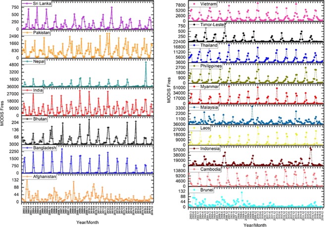
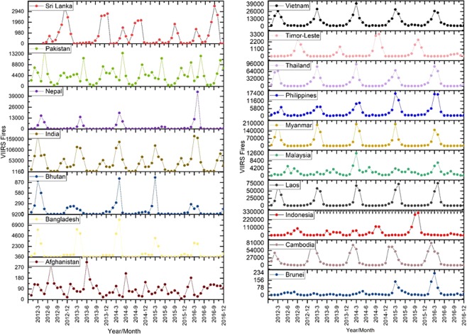
Results from averaging the MODIS fire data from 2003–2016 showed India with the highest number of annual fire counts of 73836 followed by Pakistan (8761), Nepal (3049), Bangladesh (3029) and the lowest in Afghanistan (298). Averaging the VIIRS fire data from 2012–2016 suggested India having the highest number of annual fire counts of 551649, Pakistan (53998), Nepal (32018), Bangladesh (10972), Sri Lanka (9185), Bhutan (1411), and least for Afghanistan (1075) (Fig. 1).
Figure 1.
(a,b) Trends in vegetation fires in South Asian countries retrieved using MODIS Aqua and Terra combined data (2003–2016). A relatively higher number of fires can be seen for India in South Asia and Indonesia and Myanmar in Southeast Asia every year.
In Southeast Asia, averaging the MODIS fire data from 2003–2016 suggested highest fire counts for Indonesia (79476), followed by Myanmar (70084), Laos (39666) and the lowest for Brunei (75). VIIRS detected fires (2012–2016) showed the highest number of fires for Indonesia (412080) followed by Myanmar (368533), Cambodia (199646), others and least for Singapore (32).
Trends in vegetation fires in South and Southeast Asia countries retrieved using VIIRS 375 I-band data (2012–2016) are shown in Fig. 2. Table 1 highlights the differences in MODIS (Aqua and Terra combined) and VIIRS active fires. Of the different countries in South Asia, VIIRs detected fires were 17.71 higher in Nepal than the MODIS. This is a significant improvement considering the hilly terrain in Nepal. In overall, the VIIRS detected fires were higher than MODIS by a factor of 7.2 in South Asian countries and 5.12 factor higher in Southeast Asian countries. The higher detection of fires by VIIRS can be primarily attributed to its finer spatial resolution and higher pixel fidelity along the swath due to pixel aggregation scheme compared to MODIS46. The results can have significant implications concerning increased smoke release and contribution to GHG emissions and aerosols.
Figure 2.
(a,b) Trends in vegetation fires in South Asian countries retrieved using VIIRS 375 I-band data (2012–2016). A relatively higher number of fires can be seen for India in South Asia and Indonesia and Myanmar in Southeast Asia every year.
Table 1.
MODIS Fires (Aqua and Terra Combined) in comparison to VIIRS.
| Country | MODIS | VIIRS | Factor |
|---|---|---|---|
| Afghanistan | 298 | 1075 | 3.60 |
| Bangladesh | 3029 | 10972 | 3.62 |
| Bhutan | 347 | 1411 | 4.07 |
| India | 73836 | 551649 | 7.47 |
| Nepal | 3049 | 53998 | 17.71 |
| Pakistan | 8761 | 32018 | 3.65 |
| Sri Lanka | 1417 | 9185 | 6.48 |
| South Asia Average | 12962 | 94330 | 7.28 |
| Brunei | 75 | 253 | 3.37 |
| Cambodia | 32806 | 199646 | 6.09 |
| Indonesia | 79476 | 412080 | 5.18 |
| Laos | 39666 | 142354 | 3.59 |
| Malaysia | 6068 | 24470 | 4.03 |
| Myanmar | 70084 | 368533 | 5.26 |
| Philippines | 5977 | 35038 | 5.86 |
| Singapore | 7 | 32 | 4.63 |
| Thailand | 32533 | 194262 | 5.97 |
| Timor-Leste | 857 | 5118 | 5.97 |
| Vietnam | 20346 | 90917 | 4.47 |
| Southeast Asia Average | 26172 | 133882 | 5.12 |
Fire data from 2003–2016 for MODIS and 2012–2016 for VIIRS has been averaged for different countries. VIIRS detected fires were much higher than MODIS as shown in the factor column.
MODIS fire return frequency
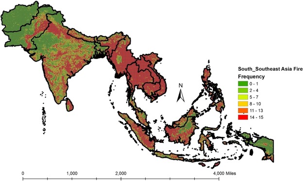
Spatially-gridded fire return frequencies at 10-minute grid intervals for the entire S/SEA from 2003–2017 are shown in Fig. 3. The scale varies from 0–15, indicating the lowest value of 0 with cells without fires during fifteen-years (2003–2016) and a maximum value of 15 for grid cells with fires every year. Table 2 highlights the percentage of 10-minute grid cells impacted by fires in different S/SEA countries. Thus, for example, of the total cells of 9555 grid cells in India, 1701 cells (17.80%) were impacted by fires every year (i.e., frequency = 15). Of the different countries, Laos, Cambodia, Thailand, and Myanmar had the highest percentage of recurring fires. Further, 30% of grid cells in S/SEA countries (Table 3) had fires occurring every year.
Figure 3.
Fire frequencies in South and Southeast Asia at 10-minute grid intervals. The scale varies from 0–15, indicating the lowest value of 0 with grid cells without fires and a maximum value of 15 with the grid cells having fires every year during the fifteen years (2003–2017) time period. Relatively higher fire frequencies can be found for Myanmar, Thailand, Cambodia, and Laos in Southeast Asia.
Table 2.
MODIS Fires (Aqua and Terra combined) at 10-minute grid intervals depicting cells impacted by fires every year over a fifteen year time period (2003–2017).
| Country | Total 10 m Grid cells | Cells with a fire frequency of 15 | % of grid cells |
|---|---|---|---|
| India | 9555 | 1701 | 17.802 |
| Bangladesh | 323 | 37 | 11.455 |
| Bhutan | 101 | 7 | 6.931 |
| Myanmar | 1849 | 1389 | 75.122 |
| Cambodia | 471 | 371 | 78.769 |
| Indonesia | 4572 | 974 | 21.304 |
| Laos | 575 | 551 | 95.826 |
| Malaysia | 785 | 124 | 15.796 |
| Nepal | 410 | 64 | 15.610 |
| Pakistan | 2747 | 397 | 14.452 |
| Philippines | 577 | 208 | 36.049 |
| Srilanka | 178 | 80 | 44.944 |
| Thailand | 1345 | 1009 | 75.019 |
| Vietnam | 792 | 494 | 62.374 |
| Total | 24280 | 7406 | 30.502 |
Thirty percent of 10-minute grid cells in south/southeast Asia had recurrent fires (2003–2017).
Table 3.
Trends in MODIS Fires (Aqua and Terra Combined) for different Countries (2003–2016).
| Country | FC Seasonal Kendall Test | FC Sens slope Estimator | FRP Seasonal Kendall Test | FRP Sens Slope Estimator |
|---|---|---|---|---|
| Cambodia | 426 (0.001) | 19.733 | 340 (0.005) | 307.4 |
| Indonesia | 28 (0.8) | 9.92 | −44.0 (0.695) | −449 |
| Laos | 15 (0.773) | 0 | 22 (0.688) | 22.0 |
| Malaysia | −59 (0.455) | −3.0 | −42.0 (0.515) | −58.19 |
| Maldives | −86 (0.251) | 0 | −112 (0.183) | −0.743 |
| Myanmar | 23 (0.736) | 0.127 | −14 (0.817) | −2.906 |
| Philippines | −75 (0.435) | −1.917 | −82 (0.429) | −39 |
| Thailand | −69 (0.224) | −2.667 | −100 (0.254) | −48.86 |
| Timor Leste | −163 (0.004) | −0.40 | −169 (0.99) | −6.844 |
| Vietnam | 126 (0.050) | 12.8 | 30 (0.597) | 68.64 |
| Afghanistan | −103 (0.214) | −0.5 | −116 (0.041) | −15.77 |
| Bangladesh | 145 (0.078) | 0.222 | 57 (0.446) | 0.747 |
| Bhutan | −22.0 (0.685) | 0.724 | −22.0 (0.638) | 0 |
| India | 218 (0.004) | 20.857 | 102 (0.039) | 131.49 |
| Nepal | 21 (0.714) | 0 | −12.0 (0.841) | 0 |
| Pakistan | 136 (0.074) | 6.417 | 130 (0.066) | 116.09 |
| Sri Lanka | −153 (0.072) | −0.50 | −166 (0.049) | −10.54 |
MODIS fire and FRP trends in different countries
Trends in MODIS fires for different countries are given in Table 3. Of the different countries, increasing trend in fires were found for India (p = 0.004), Cambodia (p = 0.001), and Vietnam (p = 0.050) and decreasing trend for Timor Leste (p = 0.004). Thiel’s Sen’s slope which indicates the magnitude in trend was relatively high for countries with increasing fires, i.e., India, Vietnam, and Cambodia. Pakistan and Bangladesh had higher p-values of 0.074 and 0.078 for fires with a positive slope. In case of FRP, Afghanistan and Sri Lanka had a negative slope value of 0.04 and 0.049 whereas Cambodia, India, and Pakistan had a positive slope with highly significant (p) values (Table 3). These results suggest increased fires as well as FRP for India and Cambodia as depicted in highly significant p values in M-K test as well as Sen’s slope estimator.
MODIS fires in different land cover categories
Using MERIS data (300 m), MODIS fire data has been partitioned into different land cover types to assess the major land cover types with the highest percentage of fires. In South Asia, Pakistan (91%), Sri Lanka (59.70%), and India (47.92%) had the highest percentage of fires in croplands mainly attributed to agricultural residue burning. Most of the agricultural fires in India and Pakistan are due to rice-wheat and sugarcane crop residue burning in the Indo-Ganges region26,34,58. In Sri Lanka, information on agricultural residue burning is meagre however one of the recent studies suggests Rice straw as the most commonly burnt residue59. In contrast, Nepal (82.84%) and Bhutan (75.56%) had the highest percentage of fires in forest land cover types which are mostly human initiated. The primary causes include agricultural fires spreading from farms to forests, abandoned cooking fires, carelessness due to smokers, firewood collectors60. In Afghanistan, 43.75% of total fires were in grasslands/sparsely vegetated category mostly in the Hindu Kush alpine meadow as well as the Ghorat-Hazarajat alpine meadow. In Bangladesh (42.17%) and Sri Lanka (22.39%) had relatively higher percent fires were found in shrublands suggesting degraded nature of forests which are highly vulnerable to fires (Fig. 4a,b).
Figure 4.
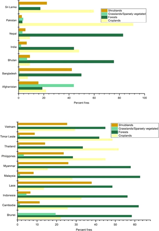
(a,b) MODIS (Aqua and Terra) retrieved fires in different land cover types in South Asia and Southeast Asian countries. MERIS (300 m) data has been used to retrieve land cover types in different countries. Fires in croplands and forests dominate different countries.
In Southeast Asia, Thailand (51.75%), followed by Timor Leste (48.75%) and the Philippines (44.99%) had the highest percentage of fires in croplands due to rice, maize and sugarcane agricultural residue burning27,61,62, whereas Malaysia (62.65%), Cambodia (61.94%), Brunei (58.37%) and Myanmar (57.82%) had the highest percentage of fires in forests mainly due to slash and burn agriculture, and timber harvesting. Brunei also had the highest percent of fires in grassland/sparsely vegetated category, whereas, Laos (37.88%), Myanmar (25.95%), Vietnam (25.33%) and the Philippines (23.58%) had the highest percentage of fires in the shrublands category.
MODIS fire and FRP trends in different land cover types
We also assessed the fire and FRP trends in different land cover types (Supplementary Material). MERIS (300 m) data has been used for vegetation partition into four major categories, i.e., croplands, forests, grasslands, and shrublands. Increasing fire trends in croplands are found for India, Pakistan and Vietnam attributed to agricultural residue burning whereas decreasing trend has been found for Malaysia. In the case of forests, except Cambodia which had a positive trend, Afghanistan, Thailand, Pakistan, and Sri Lanka showed a negative trend. India, Pakistan, Indonesia, and Cambodia showed a positive fire trend in grasslands, whereas, Maldives, Nepal and Sri Lanka showed a negative trend. Further, in the case of shrub lands, Pakistan and India showed a positive trend whereas Sri Lanka, Timor Leste and Myanmar showed a negative trend. In the case of FRP, positive trends were found for forests in the Philippines and grasslands in Thailand. For rest of the countries, FRP trends in different land cover types were not significant.
VIIRS fire and FRP trends in different countries
Except for the Philippines which showed an increasing trend in fires as well as FRP, for all other countries, the VIIRS fire data trends were not significant. We attribute the insignificant statistical trends from VIIRS to short period (2012–2016) of available data (Supplementary Material).
VIIRS fire and FRP trends in different land cover types
VIIRS data did not show significant trends at a country level as well as across different land cover types. However, we found a decreasing trend in fires for Laos croplands, an increasing trend in Thailand forests and a decreasing trend in Afghanistan grasslands (Fig. 3; Supplementary Material). FRP in Philippines showed significant positive trends for forests whereas Thailand showed increasing trends in FRP for grasslands (Supplementary Material). Additional years of data are needed to assess trends using VIIRS.
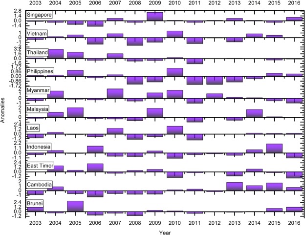
Anomalies in fires
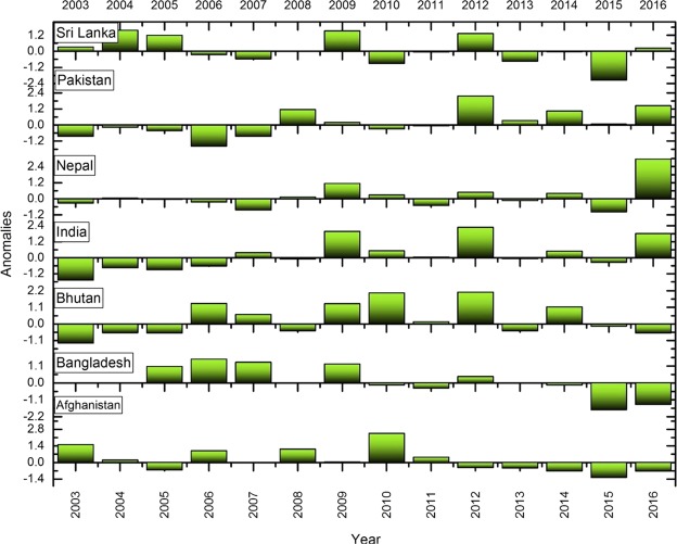
We used fire anomalies, i.e., the departure from an average value of fire counts over a fourteen-year time in different countries to capture fire variations. A positive anomaly means that the fires were higher in a specific year than normal and a negative anomaly indicates fewer fires than normal for the specific year. Figures 5, 6 depicts the anomalous years where fires are profoundly low. For example, in India, relatively high positive anomalies were found during 2009, 2012 and 2016 whereas negative anomalies are seen during 2003. In Cambodia, high positive anomalies are found during 2013 and 2015. The anomaly statistics can be used to infer drivers of fires. In the case of Indonesia, the positive fire anomalies found during 2006 and 2015 (Fig. 6) can be related to the El Nino induced droughts and positive dipole6,63,64. El Nino is associated with an abnormal warming of surface waters in the east and central equatorial Pacific which negatively impacts the monsoon, whereas, La Nina results in abnormal cooling of waters aiding monsoon. However, the influence of El Nino/La Nina can be inconsistent. For example, the El Nino years include 2002, 2004, 2009 and 2015; except for 2009, which showed a significant positive anomaly with higher number of fires, 2004 and 2015 had negative fire anomalies. Thus, relating El Nino events to fire events should be done cautiously. In addition to the anomalies, we also performed an in-depth analysis to explore the relationships between mean monthly fires, temperate and precipitation.
Figure 5.
Standardized fire anomalies in South Asia. A positive anomaly means that the fires were higher in a specific year than normal and a negative anomaly indicates that the lesser fires than normal for the specific year.
Figure 6.
Standardized fire anomalies in Southeast Asia. A positive anomaly means that the fires were higher in a specific year than normal and a negative anomaly indicates that the lesser fires than normal for the specific year.
Climate-precipitation relationships
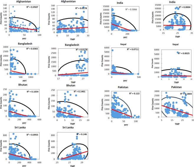
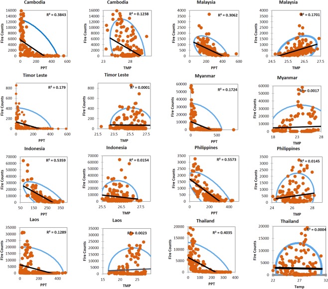
The relationship between monthly fires, precipitation, and temperature in South and South East Asian countries is shown in Figs 7, 8 and 9. Most of the countries showed a negative slope with decrease in fire counts with an increase in precipitation, however, the r2 values were not strong except for India and Bhutan where precipitation could explain 30% and 16% of the variation in fires. Mean monthly temperature showed poor correlations and, in some cases, had no relationship as in Nepal or negative slope as in Pakistan.
Figure 7.
The relationship between monthly fires, precipitation (PPT) and temperature (TMP) in South Asia countries. The blue dots represent MODIS fires, black ellipse correspond to a 95% confidence interval whereas the red line represents the regression line. The r2 value also given in the plot.
Figure 8.
The relationship between monthly fires, precipitation, and temperature in Southeast Asia countries. The orange dots represent MODIS fires, blue ellipse correspond to a 95% confidence interval whereas the black line represents the regression line. The r2 value also given in the plot.
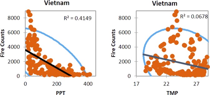
Figure 9.
The relationship between monthly fires, precipitation, and temperature for Vietnam. The orange dots represent MODIS fires, blue ellipse correspond to a 95% confidence interval whereas the black line represents the regression line. The r2 value also given in the plot.
Relatively, in Southeast Asian countries, precipitation showed strong negative correlations with fire counts. For example, in the Philippines, 55% of variations in fires could be explained by the precipitation; similarly, 53% in Indonesia, 40% in Thailand, 41% in Vietnam, 38% percent in Cambodia, and 17% in Timor Leste. However, similar to South Asian countries, correlations between the fire counts and temperature were poor. Our results highlighting monthly precipitation as an essential driver of fires is consistent with similar results reported in the literature35,65,66. The results reported in this study can contribute to a better characterization of fires based on precipitation and feeding into fuel-behavior models of fire suppression.
In contrast to the climate drivers, our literature review suggests that most of the fires in S/SEA are anthropogenic. A variety of reasons have been documented for example, forests are set on fire for inducing the growth of new grass for grazing1, clearing the land for agriculture such as through slash and burn20,67–70, for collecting minor forest produce such as honey, edible and non-edible oil seeds, and flowers, to hunt wild animals71, in addition to crop residue burning in agricultural landscapes27,71. Incorporating these drivers for predicting fire risk in different landscapes of S/SEA countries is a challenging task. Since some of the countries in S/SEA still hold precious forests, protecting them from further fire disasters should be a higher priority for conservation.
Conclusions
Fire management in S/SEA countries is an increasingly complex and challenging problem that requires detailed information about the occurrence, geographic variation, trends, anomalies, and main drivers of fire within the region. Our current study provides a comprehensive analysis of the above metrics. In South Asia, India had the highest number of annual fires followed by Pakistan and others whereas in Southeast Asia, Indonesia had the highest followed by Myanmar, Laos, etc. Frequency analysis was useful to identify hotspots of grid cells having recurrent fires. Frequency analysis suggested nearly 30.5% of South/Southeast Asia with recurrent fires every year within a fifteen year time period with highest percentage in Laos (95.82%), Cambodia (78.7%), Thailand (75.0%), and Myanmar (75.1%). The frequency data can be integrated into emission models to address biomass burning impacts including transboundary air pollution. Of the different countries, increasing trend in fires were found for India (p = 0.004), Cambodia (p = 0.001), and Vietnam (p = 0.050) and decreasing trend for Timor Leste (p = 0.004). In case of FRP, Afghanistan and Sri Lanka had a negative slope value of 0.04 and 0.049 whereas Cambodia, India, and Pakistan had a positive slope with highly significant (p) values.
Partitioning of fires into different land cover categories suggested agricultural fires are as equally recurrent as forest fires, requiring immediate attention specifically in India (p = 0.006), Pakistan (p = 0.047), and Vietnam (p = 0.004) where they are increasing. Agricultural fires can be controlled through stringent and enforced policies and by promoting incorporation of residues into the soil rather than burning. Specific to forest fires, Nepal (82.84%) and Bhutan (75.56%) had the highest percentage of fires in forest land cover types which are mostly human initiated. In the hilly regions, human dependence on forests is significant, thus developing sustainable forest management plans involving local people (community based fire management) should be the priority. Also, our results suggest increasing shrub land fires in India (p = 0.054) and Pakistan (p = 0.073) and we attribute these to forest degradation and fragmentation.
We also characterized anomalies in fires. In India, relatively high positive anomalies were found during 2009, 2012 and 2016 whereas negative anomalies during 2003. For Cambodia, high positive anomalies are found during 2013 and 2015. The anomaly statistics can be used to infer drivers of fires. Also, our results suggests precipitation as an important fire suppressing agent in Southeast Asian countries compared to the South Asian countries. For example, in the Philippines, 55% of variations in fires could be explained by the precipitation; similarly, 53% in Indonesia, 40% in Thailand, 41% in Vietnam, 38% percent in Cambodia, and 17% in Timor Leste. Thus, integrating precipitation data into fire-behavior models for quantifying fire risk can yield promising results. Collectively, our findings highlight essential fire metrics useful for fire management and mitigation in S/SEA countries.
Supplementary information
Acknowledgements
We are grateful to the MODIS and VIIRS fire product developers for freely sharing the data. The work contributes to the South/Southeast Asia Research Initiative (www.sari.umd.edu) and NASA Land Cover/Land Use Change Program research (www.lcluc.umd.edu).This work is supported by the NASA grant NNX10AU77G to the first author.
Author Contributions
K.V. conceived, analyzed data and wrote the manuscript. K.L. helped in data cross-checking and editing. S.B. helped in manuscript formatting and editing. L.G., W.S. and C.J. provided important science suggestions to strengthen the manuscript, helped in refining and editing.
Data Availability
All data and materials used the study are open access. We will be glad to share the same freely on request.
Competing Interests
The authors declare no competing interests.
Footnotes
Publisher’s note: Springer Nature remains neutral with regard to jurisdictional claims in published maps and institutional affiliations.
Supplementary information
Supplementary information accompanies this paper at 10.1038/s41598-019-43940-x.
References
- 1.Stott, P. A., Goldammer, J. G. & Werner, W. L. The role of fire in the tropical lowland deciduous forests of Asia. In Fire in the tropical biota 32–44 (Springer, 1990).
- 2.Stolle F, Chomitz KM, Lambin EF, Tomich TP. Land use and vegetation fires in Jambi Province, Sumatra, Indonesia. For. Ecol. Manag. 2003;179:277–292. doi: 10.1016/S0378-1127(02)00547-9. [DOI] [Google Scholar]
- 3.Prasad VK, Badarinath KVS, Eaturu A. Biophysical and anthropogenic controls of forest fires in the Deccan Plateau, India. J. Environ. Manage. 2008;86:1–13. doi: 10.1016/j.jenvman.2006.11.017. [DOI] [PubMed] [Google Scholar]
- 4.Vadrevu KP, Badarinath KVS, Anuradha E. Spatial patterns in vegetation fires in the Indian region. Environ. Monit. Assess. 2008;147:1. doi: 10.1007/s10661-007-0092-6. [DOI] [PubMed] [Google Scholar]
- 5.Siegert F, Ruecker G, Hinrichs A, Hoffmann AA. Increased damage from fires in logged forests during droughts caused by El Nino. Nature. 2001;414:437. doi: 10.1038/35106547. [DOI] [PubMed] [Google Scholar]
- 6.Field RD, Van Der Werf GR, Shen SS. Human amplification of drought-induced biomass burning in Indonesia since 1960. Nat. Geosci. 2009;2:185. doi: 10.1038/ngeo443. [DOI] [Google Scholar]
- 7.Miettinen J, Shi C, Liew SC. Fire distribution in Peninsular Malaysia, Sumatra and Borneo in 2015 with special emphasis on peatland fires. Environ. Manage. 2017;60:747–757. doi: 10.1007/s00267-017-0911-7. [DOI] [PubMed] [Google Scholar]
- 8.Toky, O. P. & Ramakrishnan, P. S. Secondary succession following slash and burn agriculture in North-Eastern India: I. biomass, litterfall and productivity. J. Ecol. 735–745 (1983).
- 9.Raman TS. Effect of slash-and-burn shifting cultivation on rainforest birds in Mizoram, northeast India. Conserv. Biol. 2001;15:685–698. doi: 10.1046/j.1523-1739.2001.015003685.x. [DOI] [Google Scholar]
- 10.Prasad VK, et al. Biomass and combustion characteristics of secondary mixed deciduous forests in Eastern Ghats of India. Atmos. Environ. 2001;35:3085–3095. doi: 10.1016/S1352-2310(01)00125-X. [DOI] [Google Scholar]
- 11.Borggaard OK, Gafur A, Petersen L. Sustainability appraisal of shifting cultivation in the Chittagong Hill Tracts of Bangladesh. AMBIO J. Hum. Environ. 2003;32:118–123. doi: 10.1579/0044-7447-32.2.118. [DOI] [PubMed] [Google Scholar]
- 12.Blanford HR. Highlights of one hundred years of forestry in Burma. Emp. For. Rev. 1958;37:33–42. [Google Scholar]
- 13.Biswas S, Vadrevu KP, Lwin ZM, Lasko K, Justice CO. Factors controlling vegetation fires in protected and non-protected areas of Myanmar. PLoS One. 2015;10:e0124346. doi: 10.1371/journal.pone.0124346. [DOI] [PMC free article] [PubMed] [Google Scholar]
- 14.Kleinman PJA, Pimentel D, Bryant RB. The ecological sustainability of slash-and-burn agriculture. Agric. Ecosyst. Environ. 1995;52:235–249. doi: 10.1016/0167-8809(94)00531-I. [DOI] [Google Scholar]
- 15.Olofson H. Swidden and kaingin among the southern Tagalog: a problem in Philippine Upland ethno-agriculture. Philipp. Q. Cult. Soc. 1980;8:168–180. [Google Scholar]
- 16.Ketterings QM, Wibowo TT, Van Noordwijk M, Penot E. Farmers’ perspectives on slash-and-burn as a land clearing method for small-scale rubber producers in Sepunggur, Jambi Province, Sumatra, Indonesia. For. Ecol. Manag. 1999;120:157–169. doi: 10.1016/S0378-1127(98)00532-5. [DOI] [Google Scholar]
- 17.Tacconi L, Vayda AP. Slash and burn and fires in Indonesia: A comment. Ecol. Econ. 2006;56:1–4. doi: 10.1016/j.ecolecon.2005.03.034. [DOI] [Google Scholar]
- 18.Grandstaff, T. B. Shifting cultivation in northern Thailand. Possibilities for development. (1980).
- 19.Roder W, Phengchanh S, Keobulapha B. Weeds in slash-and-burn rice fields in northern Laos. Weed Res. 1997;37:111–119. doi: 10.1046/j.1365-3180.1996.d01-6.x. [DOI] [Google Scholar]
- 20.Inoue, Y. Ecosystem Carbon Stock, Atmosphere, and Food Security in Slash-and-Burn Land Use: A Geospatial Study in Mountainous Region of Laos. In Land-Atmospheric Research Applications in South and Southeast Asia 641–665 (Springer, 2018).
- 21.Scheidel, A. & Work, C. Large-scale forest plantations for climate change mitigation? New frontiers of deforestation and land grabbing in Cambodia. Glob. Governance Politics Clim. Justice Agrar. Justice Link. Chall. 11 (2016).
- 22.Nguyen TL, Vien TD, Lam NT, Tuong TM, Cadisch G. Analysis of the Sustainability with the Composite Swidden Agroecosystem: 1. Partial Nutrient Balance and Recovery Times of Uplands Swiddens. Agric. Ecosyst. Environ. 2008;128:37–51. doi: 10.1016/j.agee.2008.05.004. [DOI] [Google Scholar]
- 23.Carlson KM, et al. Carbon emissions from forest conversion by Kalimantan oil palm plantations. Nature Climate Change. 2013;3(3):283. doi: 10.1038/nclimate1702. [DOI] [Google Scholar]
- 24.Marlier ME, et al. Fire emissions and regional air quality impacts from fires in oil palm, timber, and logging concessions in Indonesia. Environ. Res. Lett. 2015;10:085005. doi: 10.1088/1748-9326/10/8/085005. [DOI] [Google Scholar]
- 25.Vadrevu KP, Lasko K, Giglio L, Justice C. Vegetation fires, absorbing aerosols and smoke plume characteristics in diverse biomass burning regions of Asia. Environ. Res. Lett. 2015;10:105003. doi: 10.1088/1748-9326/10/10/105003. [DOI] [Google Scholar]
- 26.Vadrevu K, Ohara T, Justice C. Land cover, land use changes and air pollution in Asia: a synthesis. Environ. Res. Lett. 2017;12:120201. doi: 10.1088/1748-9326/aa9c5d. [DOI] [PMC free article] [PubMed] [Google Scholar]
- 27.Oanh, N. T. K., Permadi, D. A., Dong, N. P. & Nguyet, D. A. Emission of Toxic Air Pollutants and Greenhouse Gases from Crop Residue Open Burning in Southeast Asia. In Land-Atmospheric Research Applications in South and Southeast Asia 47–66 (Springer, 2018).
- 28.Lasko K, Vadrevu K. Improved rice residue burning emissions estimates: Accounting for practice-specific emission factors in air pollution assessments of Vietnam. Environ. Pollut. 2018;236:795–806. doi: 10.1016/j.envpol.2018.01.098. [DOI] [PMC free article] [PubMed] [Google Scholar]
- 29.Vadrevu KP, Justice CO. Vegetation fires in the Asian region: satellite observational needs and priorities. Glob Env. Res. 2011;15:65–76. [Google Scholar]
- 30.Ojima DS, Schimel DS, Parton WJ, Owensby CE. Long-and short-term effects of fire on nitrogen cycling in tallgrass prairie. Biogeochemistry. 1994;24:67–84. doi: 10.1007/BF02390180. [DOI] [Google Scholar]
- 31.Bruun TB, De Neergaard A, Lawrence D, Ziegler AD. Environmental consequences of the demise in swidden cultivation in Southeast Asia: carbon storage and soil quality. Hum. Ecol. 2009;37:375–388. doi: 10.1007/s10745-009-9257-y. [DOI] [Google Scholar]
- 32.Baker, P. J. & Bunyavejchewin, S. Fire behavior and fire effects across the forest landscape of continental Southeast Asia. In Tropical Fire Ecology 311–334 (Springer, 2009).
- 33.Turner MG, Romme WH, Gardner RH, O’Neill RV, Kratz TK. A revised concept of landscape equilibrium: disturbance and stability on scaled landscapes. Landsc. Ecol. 1993;8:213–227. doi: 10.1007/BF00125352. [DOI] [Google Scholar]
- 34.Gupta, P. K. et al. Study of trace gases and aerosol emissions due to biomass burning at shifting cultivation sites in East Godavari District (Andhra Pradesh) during INDOEX IFP-99. Curr. Sci. 186–196 (2001).
- 35.Van Der Werf, G. R., Randerson, J. T., Giglio, L., Gobron, N. & Dolman, A. J. Climate controls on the variability of fires in the tropics and subtropics. Glob. Biogeochem. Cycles22 (2008).
- 36.Badarinath KVS, Sharma AR, Kharol SK, Prasad VK. Variations in CO, O3 and black carbon aerosol mass concentrations associated with planetary boundary layer (PBL) over tropical urban environment in India. J. Atmospheric Chem. 2009;62:73–86. doi: 10.1007/s10874-009-9137-2. [DOI] [Google Scholar]
- 37.Wang, S.-H., Lin, N.-H., Chou, M.-D. & Woo, J.-H. Estimate of radiative forcing of Asian biomass-burning aerosols during the period of TRACE-P. J. Geophys. Res. Atmospheres112 (2007).
- 38.Itahashi, S., Uno, I., Irie, H., Kurokawa, J.-I. & Ohara, T. Impacts of Biomass Burning Emissions on over Tropospheric Continental NO Southeast 2 Vertical Asia Column Density. Land-Atmospheric Res. Appl. South Southeast Asia 67 (2018).
- 39.Huang, J. et al. Long-range transport and vertical structure of Asian dust from CALIPSO and surface measurements during PACDEX. J. Geophys. Res. Atmospheres113 (2008).
- 40.Hyer EJ, Chew BN. Aerosol transport model evaluation of an extreme smoke episode in Southeast Asia. Atmos. Environ. 2010;44:1422–1427. doi: 10.1016/j.atmosenv.2010.01.043. [DOI] [Google Scholar]
- 41.Giglio L, Schroeder W, Justice CO. The collection 6 MODIS active fire detection algorithm and fire products. Remote Sens. Environ. 2016;178:31–41. doi: 10.1016/j.rse.2016.02.054. [DOI] [PMC free article] [PubMed] [Google Scholar]
- 42.Li F, Zhang X, Kondragunta S, Csiszar I. Comparison of fire radiative power estimates from VIIRS and MODIS observations. J. Geophys. Res. Atmospheres. 2018;123:4545–4563. doi: 10.1029/2017JD027823. [DOI] [Google Scholar]
- 43.Wooster, M. J., Roberts, G., Perry, G. L. W. & Kaufman, Y. J. Retrieval of biomass combustion rates and totals from fire radiative power observations: FRP derivation and calibration relationships between biomass consumption and fire radiative energy release. J. Geophys. Res. Atmospheres110 (2005).
- 44.Ichoku C, Ellison L. Global top-down smoke-aerosol emissions estimation using satellite fire radiative power measurements. Atmospheric Chem. Phys. 2014;14:6643–6667. doi: 10.5194/acp-14-6643-2014. [DOI] [Google Scholar]
- 45.Wooster MJ, et al. Meteosat SEVIRI Fire Radiative Power (FRP) products from the Land Surface Analysis Satellite Applications Facility (LSA SAF): Part 1-algorithms, product contents & analysis. Atmospheric Chem. Phys. 2015;15:13217–13239. doi: 10.5194/acp-15-13217-2015. [DOI] [Google Scholar]
- 46.Schroeder W, Oliva P, Giglio L, Csiszar IA. The New VIIRS 375 m active fire detection data product: Algorithm description and initial assessment. Remote Sens. Environ. 2014;143:85–96. doi: 10.1016/j.rse.2013.12.008. [DOI] [Google Scholar]
- 47.Wooster MJ, Zhukov B, Oertel D. Fire radiative energy for quantitative study of biomass burning: derivation from the BIRD experimental satellite and comparison to MODIS fire products. Remote Sens. Environ. 2003;86:83–107. doi: 10.1016/S0034-4257(03)00070-1. [DOI] [Google Scholar]
- 48.Wooster, M. J. & Zhang, Y. H. Boreal forest fires burn less intensely in Russia than in North America. Geophys. Res. Lett. 31 (2004).
- 49.Vermote, E. et al. An approach to estimate global biomass burning emissions of organic and black carbon from MODIS fire radiative power. J. Geophys. Res. Atmospheres114 (2009).
- 50.Vadrevu KP, et al. Vegetation fires in the himalayan region–Aerosol load, black carbon emissions and smoke plume heights. Atmos. Environ. 2012;47:241–251. doi: 10.1016/j.atmosenv.2011.11.009. [DOI] [Google Scholar]
- 51.Defourny, P. et al. GLOBCOVER: a 300 m global land cover product for 2005 using Envisat MERIS time series. In Proceedings of the ISPRS commission VII mid-term symposium: remote sensing: from pixels to processes (Citeseer, 2006).
- 52.Bicheron, P. et al. Products Description and Validation Report. (Toulouse, France: Medias France, 2008).
- 53.Jaagus J. Climatic changes in Estonia during the second half of the 20th century in relationship with changes in large-scale atmospheric circulation. Theor. Appl. Climatol. 2006;83:77–88. doi: 10.1007/s00704-005-0161-0. [DOI] [Google Scholar]
- 54.Sen PK. Estimates of the regression coefficient based on Kendall’s tau. J. Am. Stat. Assoc. 1968;63:1379–1389. doi: 10.1080/01621459.1968.10480934. [DOI] [Google Scholar]
- 55.Santos M, Fragoso M. Precipitation variability in Northern Portugal: data homogeneity assessment and trends in extreme precipitation indices. Atmospheric Res. 2013;131:34–45. doi: 10.1016/j.atmosres.2013.04.008. [DOI] [Google Scholar]
- 56.Partal T, Kahya E. Trend analysis in Turkish precipitation data. Hydrol. Process. 2006;20:2011–2026. doi: 10.1002/hyp.5993. [DOI] [Google Scholar]
- 57.Modarres R, Da Silva V, De PR. Rainfall trends in arid and semi-arid regions of Iran. J. Arid Environ. 2007;70:344–355. doi: 10.1016/j.jaridenv.2006.12.024. [DOI] [Google Scholar]
- 58.Ullah A, Khan D, Khan I, Zheng S. Does agricultural ecosystem cause environmental pollution in Pakistan? Promise and menace. Environ. Sci. Pollut. Res. 2018;25:13938–13955. doi: 10.1007/s11356-018-1530-4. [DOI] [PubMed] [Google Scholar]
- 59.Nanayakkara, M. P. A., Pabasara, W. G. A., Samarasekara, A. B., Amarasinghe, D. A. S. & Karunanayake, L. Synthesis and characterization of cellulose from locally available rice straw. In Engineering Research Conference (MERCon), 2017 Moratuwa 176–181 (IEEE, 2017).
- 60.Nepal’s forest fires - CIFOR Forests News. Available at, https://forestsnews.cifor.org/48187/nepals-forest-fires?fnl=en (Accessed: 19th November 2018).
- 61.Sirithian D, Thepanondh S, Sattler ML, Laowagul W. Emissions of volatile organic compounds from maize residue open burning in the northern region of Thailand. Atmos. Environ. 2018;176:179–187. doi: 10.1016/j.atmosenv.2017.12.032. [DOI] [Google Scholar]
- 62.Bhattacharyya, P. & Barman, D. Crop Residue Management and Greenhouse Gases Emissions in Tropical Rice Lands. In Soil Management and Climate Change 323–335 (Elsevier, 2018).
- 63.Gaveau DL, et al. Major atmospheric emissions from peat fires in Southeast Asia during non-drought years: evidence from the 2013 Sumatran fires. Sci. Rep. 2014;4:6112. doi: 10.1038/srep06112. [DOI] [PMC free article] [PubMed] [Google Scholar]
- 64.Pan X, Chin M, Ichoku CM, Field RD. Connecting Indonesian Fires and Drought With the Type of El Niño and Phase of the Indian Ocean Dipole During 1979–2016. J. Geophys. Res. Atmospheres. 2018;123:7974–7988. [Google Scholar]
- 65.Andela N, et al. A human-driven decline in global burned area. Science. 2017;356:1356–1362. doi: 10.1126/science.aal4108. [DOI] [PMC free article] [PubMed] [Google Scholar]
- 66.Turco M, et al. Skilful forecasting of global fire activity using seasonal climate predictions. Nat. Commun. 2018;9:2718. doi: 10.1038/s41467-018-05250-0. [DOI] [PMC free article] [PubMed] [Google Scholar]
- 67.Padoch C, Pinedo-Vasquez M. Saving slash-and-burn to save biodiversity. Biotropica. 2010;42:550–552. doi: 10.1111/j.1744-7429.2010.00681.x. [DOI] [Google Scholar]
- 68.Ramakrishnan, P. S. Shifting agriculture and sustainable development: an interdisciplinary study from north-eastern India. (Parthenon Publishing Group, 1992).
- 69.Sanchez PA, Bandy DE. Alternatives to slash and burn: A pragmatic approach to mitigate tropical deforestation. An. Acad. Bras. Ciênc. 1992;64:7–34. [Google Scholar]
- 70.Van Vliet MT, et al. Vulnerability of US and European electricity supply to climate change. Nat. Clim. Change. 2012;2:676. doi: 10.1038/nclimate1546. [DOI] [Google Scholar]
- 71.Badarinath, K. V. S., Chand, T. K. & Prasad, V. K. Agriculture crop residue burning in the Indo-Gangetic Plains–a study using IRS-P6 AWiFS satellite data. Curr. Sci. 1085–1089 (2006).
Associated Data
This section collects any data citations, data availability statements, or supplementary materials included in this article.
Supplementary Materials
Data Availability Statement
All data and materials used the study are open access. We will be glad to share the same freely on request.


