Abstract
Since in most mapping models geometric mean of different criteria are used to determine the desertification intensity, one of the most important issues in desertification studies is understanding the similar areas, which require similar management after determining the desertification intensity map. Two similar classes of desertification intensity may require different management due to differences in the criteria that affect its desertification severity. Therefore, after determining the geomorphological facies as the working units in Sistan plain, we used hierarchical cluster analysis to identify the homogeneous environmental management units (HEMUs) based on indices of MEDALUS model. According to the MEDALUS model, the studied area was divided into two categories namely medium and high desertification classes. Working units (geomorphological facies) are classified into five clusters according to HEMUs analysis based on climate, soil, vegetation, and wind erosion criteria. The first cluster (C11) include six facies with moderate and severe desertification; in all of these units the main effective factor was wind erosion, so they need the same management decisions controlling wind erosion. Two working units (1 and 4) with the same desertification severity were placed in two different clusters due to the main factors affecting each other. The results of the Mann-Whitney test showed that the value of the test statistics was 79. Also, the value of Asymp.Sig was obtained to be 0.018, which is less than 0.025 (two-tailed test), and it can be concluded that the classification of work units in the two models, clustering and desertification, is not equal (P<0.05). So It seems that using cluster analysis to identify the same units, which need the same management decision after preparing the desertification intensity, is necessary.
Introduction
A unique strategy for utilization of natural resources is commensurating with the physical power and the economic and social characteristics of the dominant region that is necessary to prevent land degradation and its geographic spread. In other words, protection, restoration, and reconstruction of natural areas will be possible when their natural and biological capacity is evaluated regarding restrictions [1,2]. Therefore, various zoning methods have been innovated and used from the past up to now as the methods evolved synchronously with the progress of science and technology development.
Ahmadi (1995) believed that the working unit could be considered as a study unit so that all studies and samples accomplished in that [3]. After facies were identified, he stated that the sequence could be concluded with the help of GIS and then working units are obtained. Then, maps of hydrology, soil, vegetation, and erosion can be used in a GIS environment to distinguish the characteristics of each work unit. Verstappen (1983) reported that geomorphological map is a valuable scientific tool and has two theoretical and practical functions [4]. The importance of geomorphological mapping is dependent on the recent progress and digital processes. Definition, description, and scientific value of the homogeneous unit’s map have attracted the researchers’ attention. Maps of landform units made applying geomorphology concepts elementary and understandable [5].
Managing the environmental regions in accordance with the sustainable regional development mandate is not an easy process since balancing the socioeconomic development and environmental conservation is often challenging [6]. This balance possibly will vary based on the high variability of the prime elements of the ecological system, i.e., the natural and socioeconomic subsystems [7].
The aim of the integrated environmental management is keeping the relationship between the resources of these two subsystems and their exploitation sustainable while avoiding (or alleviating) possible struggles and decreasing the uncertainties in terms of planning and decision-making [6]. Nevertheless, the appropriate management of a desert region requires a clear picture of the desertification model criteria in terms of each specific unit of territory. By sharing and accepting this vision, it would be possible to develop specific criteria to adapt uses of desert areas, settle possible conflicts, and ease the decision-making process.
It is possible to justify the spatially heterogeneous environment by selecting the homogeneous environmental management units (HEMUs), distinct homogeneous areas, or groups with comparable features (for similar approaches, See) [3,8,9]. Then, it would be necessary to link up these territorial units to a strategic national plan for operational management units [10]. These units lay the foundation for research and gathering data, and consequently, they will turn into the limits defining areas with similar land characteristics selected as decision criteria to plan and assessment [11]. Some analytical methods have been applied including multivariate classifications/clustering, factor analysis, fuzzy logic, multi-criteria analysis, and spatial overlapping [11–19].
Biophysical features like geomorphology, climate, vegetation, and biodiversity have been used to have the most comprehensive definitions of HEMU [6]. Nevertheless, developing an integrated vision of the desert zone requires the integration of the desertification model criteria into the process. It is possible to recognize groups having comparable environmental features by applying the clustering method. The analytical process that results in regionalization could be classified into separate approaches: hierarchical unit grouping and segmenting [19]. Typically, these two approaches elevate the regions according to a hierarchical criterion of higher scale unit; therefore, units are detectable as either belonging to a more upper area or forming one [15].
In most desertification studies, following the preparation of desertification intensity map and determination of desertification intensity classes in the study units, the management type is recommended based on the desertification intensity class [20–23]. In all these studies, management plans have been presented and developed following the preparation of desertification intensity maps based on common desertification models and determination of desertification risk classes in work units. In these studies, the same desertification intensity and desertification risk classes were the basis of the management plan, and the similarities between work units in terms of the indices studied have not been considered in any studies in the literature. This study is designed to answer the question whether work units with the same desertification class necessarily need to have the same management plan or not?
In this study, we propose using cluster analysis in different working units after determining the desertification intensity map to identify the units that require the same management decisions. Thus, we examined four desertification criteria (climate, soil, vegetation and wind erosion with different indices) based on the MEDALUS model in the dry east region of Iran, and then used cluster analysis to examine if the two different classes of desertification require the same management decision or not.
Materials and methods
Study area
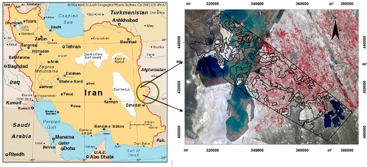
The Sistan plain, with an extension of about 15197 km2, is located in the Northeast of Sistan and Baluchistan Province (Iran) and at the end of the Hirmand River Basin and near the Afghanistan border (Fig 1).
Fig 1. Study area[Image source from public domain: USGS EarthExplorer (https://earthexplorer.usgs.gov/)].
This plain has specific geomorphological unevenness in spite of relative homogeneity. The climate of this region is xerothermic according to all of the climatic classifications. The geographical position of the study area is 21° 20΄ Northern latitudes and 61° 29΄ of Eastern longitudes. The average altitude of the plain is 490m. The average annual rainfall is 61.4 mm/year while the average annual temperature is 21°C [24]. The percentage of relative humidity is 38 percent [25]. Potential evaporation and transpiration are between 4196 mm and 5700 mm [26]. The most rainfall was concentrated in fall and winter seasons (more than that indicated in the present study), and species were classified according to their growth habit. According to Domarten climate classification method, this region has desert climate [27].
Hierarchical cluster analysis
Cluster analysis is a significant technique for classifying a ‘mountain’ of information into manageable, meaningful piles. It is a data reduction tool that creates subgroups that are more manageable than individual datum. It examines the full complement of inter-relationship between variables. In cluster analysis, it is not known which elements fit into which clusters. The data is reviewed to define the grouping or clusters.
Cluster analysis, like factor analysis, makes no distinction between dependent and independent variables. The entire set of interdependent relationships is examined. Cluster analysis is the obverse of the factor analysis. Factor analysis reduces the number of variables by grouping them into a smaller set of factors, but cluster analysis reduces the number of observations or cases by consolidating them into a smaller set of clusters. Hierarchical cluster analysis is the major statistical method for finding homogeneous groups of cases based on the measured characteristics [28]. It starts with each case as a separate cluster, i.e., there are as many clusters as cases, and then combines the clusters sequentially, reducing the number of clusters at each step until only one cluster is left. The clustering method uses the dissimilarities or distances between objects when forming the clusters. The SPSS software calculates ‘distances’ between data points regarding the specified variables.
A summary of the clustering as a general process is as follows:
The distance is calculated between all initial clusters. In most analyses, individual cases will build up the initial clusters.
Then, the distances are calculated again following the fusion of the two most similar clusters.
Step 2 is done over repeatedly until all cases ultimately turn into one cluster.
Distance can be measured in a variety of ways [28].
There are some distance measures within SPSS. The squared Euclidean distance has been applied most frequently. The Euclidean distance between two values is the arithmetic difference [28].
The squared Euclidean distance is applied more frequently than the simple Euclidean distance to impose gradually greater weight on objects that are further apart. To determine how distance is measured, it is necessary to select the clustering algorithm, namely, the rules governing which points distances are determined to specify cluster membership [28,29].
Many methods have been introduced. SPSS has five clustering algorithms; Ward’s method is the most frequently used algorithms, which differs from other methods because of applying an analysis of variance approach to assess the inter-clusters distances. Generally, this method is very effective. The total sum of squared deviations from the mean of a cluster is computed to evaluate cluster membership. The criterion for fusion is yielding the minimum likely increase in the error sum of squares.
Euclidean distance coefficient specifies the distance between units; the greater distance implies making diverse managerial decisions. This method can be advantageous especially where the region has been a large extent and divided into various geomorphological units.
Instead of spending a lot of time and money for applying desertification strategies in single units, similar approaches have been used for units in a cluster; so, more reasonable results have been achieved. Some researchers used geomorphology levels to get the particular lines of distinction between areas [30–34]. Grouping similar or very different areas was their studies result.
In this study We used Agglomerative hierarchical clustering. This is a "bottom-up" approach, each observation starts in its own cluster, and pairs of clusters are merged as one moves up the hierarchy. This method builds the hierarchy from the individual elements by progressively merging clusters [28]. The first step is to determine which elements to merge in a cluster. Usually, we want to take the two closest elements, according to the chosen distance. To do that, we need to take the distance between elements and therefore define the distance between two clusters [29]. We used Ward's method (The increase in variance for the cluster being merged) to estimate the distance between two clusters. Ward's minimum variance method is a special case of the objective function approach originally presented by Joe H. Ward [35]. Ward suggested a general agglomerative hierarchical clustering procedure, where the criterion for choosing the pair of clusters to merge at each step is based on the optimal value of an objective function [29].
Methodology
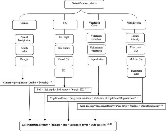
Major indices of desertification were determined based on the IMDPA (Iranian Model of Desertification Potential Assessment) and assessment of desertification intensity classified according to the MEDALUS model [36]. The MEDALUS model is one of the world's desertification assessment methods introduced by the European Commission in 1999 for desertification and land degradation studies. Higher accuracy is one of the important advantages of this method compared with other desertification assessment models. In this model, four indicators of soil quality, climate quality, vegetation quality and management are considered for desertification mapping. Each criterion has different indices. Each index gets a weight of 1 to 2, depending on its impact on desertification, according to experts and ground truth. Finally, each criterion's score is derived from the geometric mean weight of its indices. The desertification intensity (severity) map is also calculated from the geometric mean of the criteria and classified into four classes from low to very severe [37–38].
In this research, four indicators including soil, wind erosion, climate, and vegetation were selected based on the instructions of the MEDALUS model and according to the native conditions of the area presented under the IMDPA model. The weight of each indicator was calculated based on its indices. The procedure is that each indicator should be examined within the work unit.
IMDPA is a comprehensive desertification model that was developed by the University of Tehran to study the land degradation in arid and semi-arid regions of Iran [39]. Many studies have been done using this model in Iran [37–45]. The work units are determined according to slope, geology and land-use maps; however, since the slope was less than 2% in the study area, the geomorphological facies map was used to determine the work units. In this study, geobiofacies work units were considered. These work units are one of the environmental planning units, in which vegetation characteristics and land use type are considered in addition to the geomorphology of the area.
Desertification in each geomorphological facies was assessed using geographic information system (GIS) and MEDALUS model. In work units, all indicators were evaluated and the layer for each criterion was specified by calculating the geometric mean (Eq 1).
| (1) |
X: the desired criterion
Layer: Indicators of each criterion
N: Number of indicators for each criterion
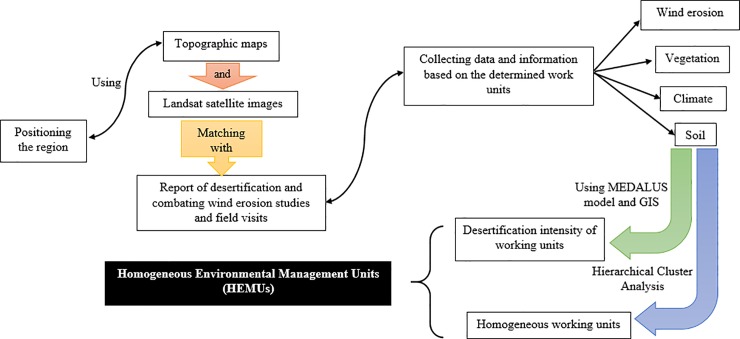
To achieve the desired goal in this study, which is determining the homogeneous environmental management units (HEMUs) of the area, we did the following steps that are briefly described.
Positioning the region and existing phenomena such as geomorphology facies in the area that were determined using the topographic maps (1:50000 and 1:250000) and Landsat satellite images (TM with the requirement combined bands) and matching them with the report of desertification and combating wind erosion studies in Sistan region [46] and field visits.
Collecting data and information on climatology, geomorphology, vegetation and soil issues based on the determined work units.
Identifying and determining the dominant processes of land degradation through the field visits according to the sub-criteria and criteria derived from the analysis of MEDALUS procedures associated with the criteria and sub-factors consistent with the study area in each working units (Fig 2).
Determining the appropriate criteria and sub-factors for the evaluation of the land degradation process in each studied working units. Tables 1 to 4 show all indicators in this study.
Fig 2. Flowchart and different steps of determining the intensity of desertification based on IMDPA model in each working unit.
Table 1. Indicators of climate criterion.
| Range Of Score | Annual Precipitation (mm) | Aridity Index (WDa) | Drought Period (Year) |
|---|---|---|---|
| Low (1–1.24) | 280< | 150–180 | 3–4 |
| Medium (1.25–1.49) | 150–280 | 150–120 | 5–6 |
| High (1.5–1.74) | 75–150 | 120–90 | 6–7 |
| Very High (1.75–2) | <75 | 0–90 | >7 |
a: Wet Days
Table 4. Indicators of wind erosion criterion.
| Range of Score | Erosion intensity | Plant cover percentage | Mulches percent(gravel >2mm) | Dust storm index(days) |
|---|---|---|---|---|
| Low (1–1.24) | 80< | PC>40 | MC>80 | <10 |
| Medium (1.25–1.49) | 50–80 | 20<PC<40 | 40<MC<80 | 10–30 |
| High (1.5–1.74) | 20–50 | 10<PC<20 | 20<MC<40 | 30–60 |
| Very High (1.75–2) | <20 | <10 | MC<20 | >60 |
Table 2. Indicators of soil criterion.
| Range Of Score | Soil depth (cm) | Soil texture | Electrical conductivity(dsm-1) | Gravel (%) |
|---|---|---|---|---|
| Low (1–1.24) | 80< | Clay, clay loam | <5 | <15 |
| Medium (1.25–1.49) | 50–80 | Fine loam | 5–8 | 15–35 |
| High (1.5–1.74) | 20–50 | Coarse loam | 9–16 | 35–75 |
| Very High (1.75–2) | <20 | Sand, sandy loam | >16 | >75 |
Table 3. Indicators of vegetation cover criterion.
| Range Of Score | Vegetation condition | Utilization of vegetation cover | Reproduction |
|---|---|---|---|
| Low (1–1.24) | Invader species are<5% of vegetation cover and annual plants >25%, Surface litter is >90%, Foliage cover of perennials is >85% | cutting of brush and uproot of the shrub is not seen, Stocking rate is equal to the rang capacity | Reproduction of plants are done naturally, The region does need not to reclamation projects, Decreases and increaser species are 70 and 30% respectively, and invaders ones are not seen |
| Medium (1.25–1.49) | Invader species are5-20% of vegetation cover annual plants 25–50%, Surface litter is70-90%, Foliage cover of perennials is 15–30% | trees are more than annual biomass, Stocking rate is a little more than annual production | Reproduction of plants are access able with low expense, Range improvement projects are successfull and effective, Decreases and increaser species are dominant, and invaders ones are seen seldom |
| High (1.5–1.74) | Invader species are20-50% of vegetation cover and annual plants are dominant, Surface litter is 30–70%, Foliage cover of perennials is 5–15% | cutting of brush, bush, and trees are apparent, Grazing is more than capacity | Regeneration of plants involve high expense, Range improvement plans are a success to some extent, Invaders and increaser species are dominant and decrease ones are not seen |
| Very High (1.75–2) | Invader species are>50% of vegetation cover, and annual plants are dominant, Surface litter is <30% foliage cover of perennials is <5% | Heavy cutting of brush, bush, and trees, Heavy stocking rate | Regeneration of plants are impossible (ecological problem), Range improvement projects have not successes till now, Invaders species are dominant, and increaser ones are not seen |
To determine the homogeneous environmental management units (HEMUs) of the area, we carried out a hierarchical cluster analysis by the use of Ward’s Minimum Variance method and applying Squared Euclidean Distance as the distance or similarity measure. It is effective in calculating the optimum number of clusters.
The data were analyzed and compared using SPSS23. The Graphical abstract of the methodology is shown in Fig 3.
Fig 3. Graphical abstract of the methodology.
Results
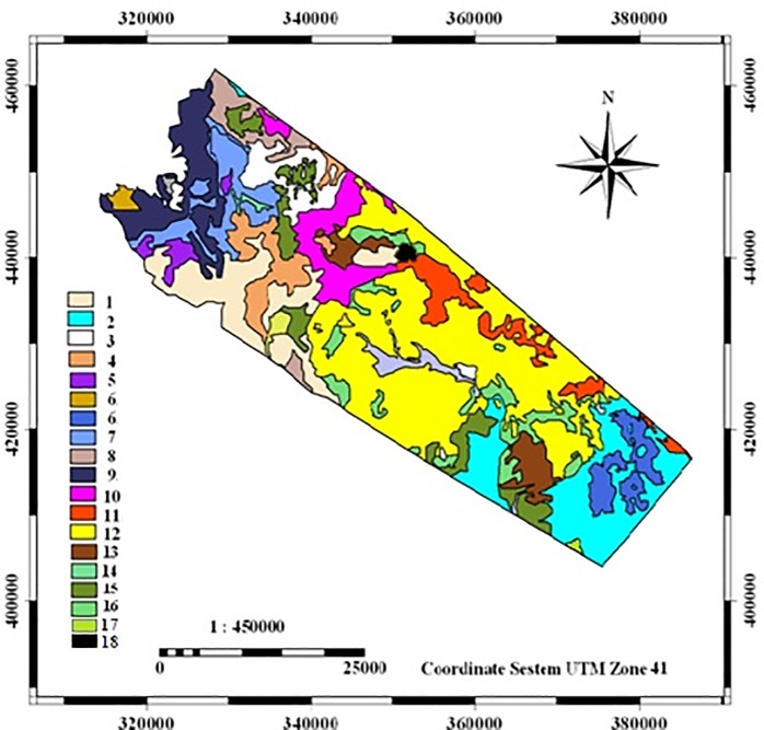
In this research geomorphological units were identified according to the basic maps of the region and in each group, four main criteria that were effective in desertification in the study area were checked out and classified with cluster analysis. The distribution of geomorphological facies in the study area, code and the names of geomorphological facies are shown in Fig 4 and Table 5, respectively.
Fig 4. Location of geomorphological facies in the area.
Table 5. Code and names of geomorphological facies in the area.
| Facies Code | Facies Name |
|---|---|
| 1 | Playa fans with fine sediment |
| 2 | Eroded marl terrace with low vein combined with claypan and hole basin |
| 3 | Relatively stiff silty clay lands |
| 4 | Relatively hard clay zone with low halophyte vegetation |
| 5 | Salina |
| 6 | Salt and bloated lands |
| 7 | Gravelly plain with large vein and high density combined with the ups and downs |
| 8 | Salt and bloated lands combined with a hard clay pan |
| 10 | Gravelly plain with medium vein and high density combined with clay pans |
| 11 | Dry and hard shell with Tamarix |
| 12 | Abandoned lands and sandy agricultural lands |
| 13 | Agricultural lands (mainly abandoned in drought) |
| 14 | Sand dunes and zone |
| 15 | Medium gravelly plain and low to medium density |
| 16 | Sand dunes |
| 17 | Hard clay lands with low Tamarix and halophyte vegetation |
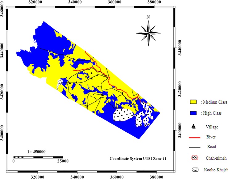
As shown in Tables 1 to 4, the current desertification status was mapped according to four criteria including climate, soil, vegetation, wind erosion, and the final scores. The results of desertification map are shown in Table 6 and Fig 5.
Table 6. The geometric mean of the quantitative values of each criterion on geomorphological facies and its cluster group.
| Facies code | Geometric mean of each criteria | Desertification severity | Cluster number | |||
|---|---|---|---|---|---|---|
| climate | soil | wind erosion | vegetation | |||
| 1 | 1.57 | 1.32 | 1.53 | 1.55 | Medium | C2 |
| 2 | 1.57 | 1.52 | 1.69 | 1.55 | high | C1222 |
| 3 | 1.57 | 1.34 | 1.75 | 1.54 | high | C1221 |
| 4 | 1.57 | 1.3 | 1.69 | 1.45 | Medium | C11 |
| 5 | 1.57 | 1.52 | 1.83 | 1.52 | high | C2 |
| 6 | 1.57 | 1.44 | 1.49 | 1.49 | Medium | C11 |
| 7 | 1.57 | 1.32 | 1.75 | 1.49 | high | C2 |
| 8 | 1.57 | 1.3 | 1.78 | 1.49 | high | C11 |
| 9 | 1.57 | 1.45 | 1.71 | 1.52 | high | C11 |
| 10 | 1.57 | 1.30 | 1.48 | 1.52 | Medium | C1221 |
| 11 | 1.57 | 1.30 | 1.48 | 1.52 | Medium | C2 |
| 12 | 1.57 | 1.42 | 1.66 | 1.52 | high | C121 |
| 13 | 1.57 | 1.28 | 1.65 | 1.48 | Medium | C121 |
| 14 | 1.57 | 1.51 | 1.75 | 1.52 | high | C1221 |
| 15 | 1.57 | 1.37 | 1.52 | 1.61 | high | C2 |
| 16 | 1.57 | 1.38 | 1.7 | 1.64 | high | C11 |
| 17 | 1.57 | 1.51 | 1.74 | 1.52 | high | C1221 |
Fig 5. Map of current desertification severity caused by climate, soil, vegetation and wind erosion.
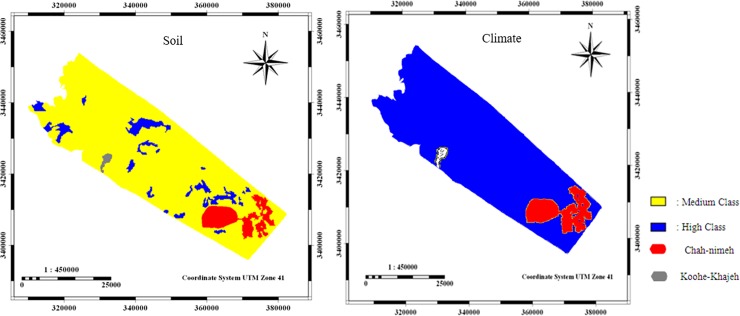
The soil and climatic criteria with an average score of 1/36 and 1/57, respectively, were categorized in moderate and severe classes of desertification (Fig 6).
Fig 6. Maps of soil and climate layer criteria.
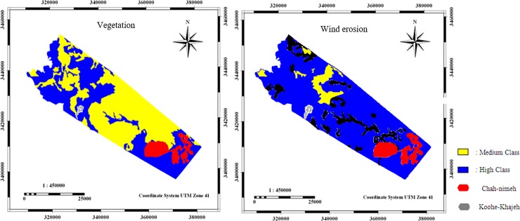
The vegetation and wind erosion criteria had an average score of 1/51 and 1/67, respectively, which were categorized in high class of desertification (Fig 7).
Fig 7. Maps of vegetation, and wind erosion layer criteria.
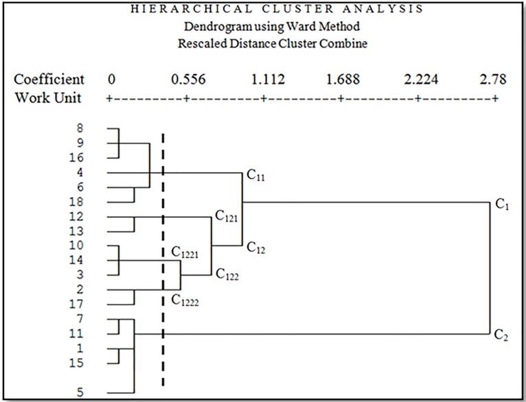
The results showed that geomorphological units were classified into five clusters based on four main criteria including climate, soil, vegetation, and wind erosion. Fig 8 shows the dendrogram of all geomorphological units based on four criteria including climate, soil, vegetation, and wind erosion. The horizontal axis represents the Euclidean Distance between units.
Fig 8. Dendrogram of all working units based on four criteria climate, soil, vegetation, and wind erosion.
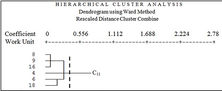
In Fig 8, all units are classified in C11, C121, C1221, C1222 and C2 clusters (the cutting line is from where there is a maximum distance between groups) based on analyzed criteria. Cutting line was chosen lower than the average Euclidean Distance (0.1853). C11 cluster contains six geomorphological units; C121 cluster contains two geomorphological units; C1221 cluster contains three geomorphological units; C1222 cluster contains two geomorphological units, and C2 cluster contains five geomorphological units. Fig 9 shows cluster C11 geomorphological facies (4, 6, 8, 9, 16, and 18).
Fig 9. Dendrogram of the first cluster.
Facies 4 is the relatively hard clay zone with low halophyte vegetation. The dominant vegetation type in this facies is Tamarix aphylla with 32 percent canopy. Other Species with this vegetation type are Salsola canescens, Suaeda fruticosa, Aeluropus littoralis, Calligonum sp. and Ephedra Strobilaceum. Facies 6 is Salt and bloated lands. The dominant vegetation type in this facies is Tamarix aphylla. Facies 8 is Salt and bloated lands combined with hard clay pan. The overriding vegetation type in this facies is degraded Aeluropus littoralis and species like Tamarix aphylla, Haloxylon persicum, and Alhagi camelorum have been observed too. Facies 9 is a dry and hard shell without vegetation or with shallow vegetation. The dominant vegetation types in this facies are Tamarix aphylla and Alhagi camelorum with 17 percent canopy. You can also see Salsola canescens, Suaeda fruticosa in this facies. Facies 16 is mainly sand dunes. The dominant vegetation types in this facies are Tamarix aphylla and Alhagi camelorum. Facies 18 is abandoned salt and bloated lands sometimes with Nebka. The dominant vegetation types in this facies are Tamarix aphylla, Haloxylon persicum, and Seidlitzia rosmarinus. The second cluster (C121) included two working units, facies 12 and 13 (Fig 10).
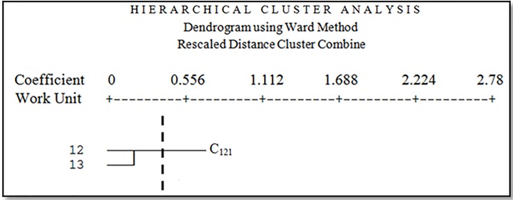
Fig 10. Dendrogram of the second cluster.
Facies 12 is abandoned lands and sandy agricultural lands. The dominant vegetation types in this facies are Tamarix aphylla, Salsola canescens and Alhagi camelorum with 20 percent canopy. Facies 13 is agricultural lands that mainly abandoned in drought. The dominant vegetation types in this facies are Alhagi camelorum, Tamarix aphylla, and Prosopis sp. The third cluster (C1221) included three working units, facies 3, 10 and 14 (Fig 11).
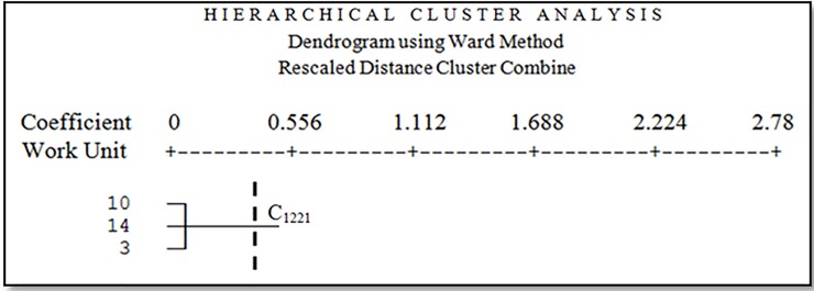
Fig 11. Dendrogram of the third cluster.
Facies 3 is relatively stiff silty clay lands. The dominant vegetation types in this facies are Salsola canescens, Prosopis sp. and Cyperus sp. with 35 percent canopy. Species with this vegetation types are Tamarix aphylla, Alhagi camelorum, and Aeluropus littoralis. Facies 10 is gravelly plain with medium vein and high density combined with clay pans. The dominant vegetation types in this facies are Ephedra strobilaceum and Zygophyllum eurypterum with 11 percent canopy. Species with this vegetation types are Aeluropus littoralis, Tamarix aphylla, Alhagi camelorum, Haloxylon persicum, and Artemisia scoparia. Facies 14 is sand dunes and zone. The dominant vegetation types in this facies are Tamarix aphylla, Cyperus sp. Alhagi camelorum with 35 percent canopy. Species with this vegetation types are Prosopis sp. and Salsola canescens. The fourth cluster (C1222) included facies 2 and 17 (Fig 12).
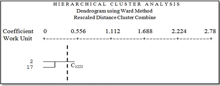
Fig 12. Dendrogram of the fourth cluster.
Facies 2 is eroded marl terrace and low vein combined with claypan and basin hole. The dominant vegetation types in this facies are Tamarix aphylla, Alhagi camelorum and Salsola canescens with 12 percent canopy, and also you can see Aeluropus littoralis in this facies.
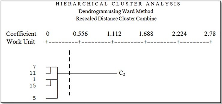
Facies 17 is hard clay lands with low Tamarix and halophyte vegetation. The dominant vegetation types in this facies are Tamarix aphylla and Aeluropus littoralis with 28 percent canopy, and you can see Haloxylon persicum, Ephedra strobilaceum, Seidlitzia rosmarinus, and Calligonum sp. The fifth cluster (C2) included facies 1, 5, 7, 11 and 15 (Fig 13).
Fig 13. Dendrogram of the fifth cluster.
Facies 1 is playa fans with fine sediment. The dominant vegetation types in this facies are Tamarix aphylla and Aeluropus littoralis with 12 percent canopy, and you can see Ephedra strobilaceum, Calligonum sp. and Artemisia scoparia. Facies 5 is Salina. The dominant vegetation type in this facies is Tamarix aphylla with 30 percent canopy, and you can see Haloxylon persicum and Salsola canescens. Facies 7 is gravelly plain with large vein and high density combined with the ups and downs. The dominant vegetation type in this facies is Tamarix aphylla with 45 percent canopy, and you can see Salsola canescens, Suaeda fruticosa, Haloxylon persicum, and Zygophyllum eurypterum. Facies 11 is a dry and hard shell with Tamarix. The dominant vegetation types in this facies are Tamarix aphylla and Aeluropus littoralis, and you can see Alhagi camelorum, Salsola canescens, Haloxylon persicum and Atriplex canisens. Facies 15 is medium gravelly plain and low to medium density. The dominant vegetation types in this facies are Tamarix aphylla and Suaeda fruticosa with 35 percent canopy.
Discussion
As shown in the cluster analysis, working units in each cluster were similar in some characteristics such as soil and vegetation type, but not equal. Webster and Oliver, (1990) confirmed the performance of cluster analysis on test and differentiation of geomorphological units and soil specifications in Brazil [47]. Working units in adjacent clusters are more similar than working units in further clusters. Multivariate analysis can specify minor differences within a group to major differences between groups [48]. According to Adam et al., (1992) in soil studies, cluster analysis is very suitable to organize the degree of similarity, so it is used to achieve classification goals [49].
Cluster analysis in geomorphological studies shows further details of the relationship between soil properties that cannot be estimated at the ground level [50]. Milton et al., (2012) analyzed physicochemical properties of the soil in three regions with multivariate analysis and confirmed the results of cluster analysis of the regions based on the first pattern [51].
In a first cluster, there are six facies that all of them have weak halophyte vegetation and the dominant vegetation type in these facies is Tamarix aphylla, Suaeda fruticosa, Haloxylon persicum, and Alhagi camelorum. All of these facies include clay pan, dry shell and salt and bloated lands due to their geomorphology. These facies have the same conditions in the process of planning for implementation of desertification due to the mentioned similarities. In this cluster, although the facies 8, 9, 16, 18, and the facies 4 and 6 are classified in the high and medium class of desertification, they are placed in the similar cluster because these facies need the same management for wind erosion and vegetation cover. Therefore, to reduce the risk of desertification in this cluster (C11), the pebble mulch and spreading of vegetation residues are used on the surface to prevent the deterioration of surface erosion and maintenance of surface soil is the best and appropriate function.
In the second cluster (C121), there are two facies, both of them include agricultural lands abandoned in drought, the dominant vegetation types are Prosopis sp., Alhagi camelorum and Tamarix aphylla. In this cluster, the best management proposal is using biological windbreak and prevent livestock entry.
Three facies were classified in the third cluster. These facies include relatively stiff clay lands and gravelly plain combined with clay pan and sand areas. The dominant vegetation types in these facies are Zygophyllum eurypterum, Ephedra strobilaceum, and Cyperus sp. with about 30 percent canopy. Due to the high sensitivity of surface soil in all homogeneous units located in C1221 cluster, we suggest using methods to increase the adhesion of aggregate particles such as clay mulch.
In the fourth cluster (C1222), there are two facies including eroded marl terrace combined with hard clay pan. In these facies, you can see low vegetation of Salsola canescens, Tamarix aphylla, Aeluropus littoralis, Calligonum sp. and Seidlitzia rosmarinus. In this cluster, which includes two work units with a low percentage of some delicate species, the management plan should be focused on restoring vegetation and using the exclusion of the area to give sufficient opportunity for plant regeneration.
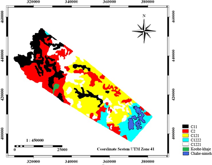
Finally, the last cluster has five working units including fine sediments, salina, gravelly plain with the ups and downs and dry and hard shell and often Artemisia scoparia, Tamarix aphylla, Zygophyllum eurypterum, Suaeda fruticosa and Atriplex canisens with about 30 percent canopy are seen in these facies. In the C2 cluster, improving vegetation, seedling, and saplings in the favorite years and consideration to economic issues and livelihoods of villagers located near these regions are the management priorities. Furthermore, measures must be taken to prevent collecting branches in these areas. The results of cluster analysis showed different classification of working units or geomorphologic facies (Fig 14).
Fig 14. Map of work units based on cluster analysis for similar management decision (C11: facies 4,6,8,9,16; C2: facies 1,5,7,11,15; C121: facies 12,13; C1222; facies 2; C1221: facies 3,10,14,17).
The prepared map of desertification intensity showed that all study units were classified in two classes of moderate and severe. However, field visits and evidence indicated that the work units located in the moderate or severe classes had significant differences. Regarding the scores given to the indicators and indices based on the desertification model, the results of cluster analysis showed that the initial work units studied fell into five different clusters. The units in each cluster have similarities in terms of all the indices studied.
We used Mann-Whitney nonparametric test in spss23 software to assess the accuracy of the results of desertification model and clustering (Fig 15). The results of the Mann—Whitney test showed that the value of the test statistics was 79. Also, the value of Asymp.Sig was obtained to be 0.018, which is less than 0.025 (two-tailed test), and it can be concluded that the classification of work units in the two models, clustering and desertification, is not equal (P<0.05).
Fig 15. The uncertainty estimation of two methods (hierarchical cluster and desertification model) using Mann-Whitney test.
It is easy to see that although desertification intensity mapping is very common to identify the same intensity classes, performing field surveys and providing methods for managing the units located in the same class will encounter problems. Therefore, in addition to using desert intensity mapping models, it is recommended to use clustering method based on similarity recognition.
According to obtained results variations of MEDALUS classification and cluster in different working units depend on climate, soil, vegetation and wind erosion criteria, and their indicators.
The results of this classification can be used to determine geomorphological groups based on soil properties [52] and reduce the classification errors in planning and implementation of management projects in desert regions [53]. In this case, the implementation of desertification in working units of the same cluster can be done as the same. We can save the time, administrative and personnel costs with the same activities in homogenous units determined by cluster analysis. Therefore, it can be concluded that using cluster analysis has a good performance in grouping homogeneous environmental management units (HEMUs).
Conclusions
In this study, the combination of a desertification mapping model and hierarchical analysis showed that different working units with the same desertification severity require different management decision. In most desertification severity mapping, the combination of different criteria is used, so the effective criterion in two similar work units may be different. Two working units (1 and 4), in this study, were categorized as medium severity of desertification but were subjected to different clusters (respectively C2 and C11) due to different affected criteria. Therefore, we suggest using cluster analysis to identify the same units, which need the same management decision after preparing the desertification intensity maps based on the conventional models.
The main basis of the proposed management plans in this study was the use of the UNEP ecosystem management program (UNEP 2004), with some modifications. According to the conditions of the study area and based on desertification intensity classes, some management plans, proportional to the conditions of each group of the same work units in the same cluster, were provided and recommended by experts (Table 7).
Table 7. The management plans recommended by experts for geobiofacies located in the same cluster.
| Cluster Number | Facies Code | Proposed Management Plans |
|---|---|---|
| C11 | 4,6,8,9,16,18 | the pebble mulch and spreading of vegetation residues are used on the surface to prevent the deterioration of surface erosion and maintenance of surface soil is the best and appropriate function. |
| C121 | 12,13 | using biological windbreak and prevent livestock entry. |
| C1221 | 3,10,14 | clay mulch. |
| C1222 | 2,17 | restoring vegetation and using the exclusion of the area to give sufficient opportunity for plant regeneration. |
| C2 | 1,5,7,11,15 | improving vegetation, seedling, and saplings in the favorite years and consideration to economic issues and livelihoods of villagers located near these regions are the management priorities |
Acknowledgments
We would like to thank all collaborating partners of the Sistan Agricultural and Natural Resources Research Centre for the support in field trials.
Data Availability
All relevant data are within the manuscript
Funding Statement
The author(s) received no specific funding for this work.
References
- 1.Eskandari H, Borji M, Khosravi H, Mesbahzadeh T (2016). Desertification of forest, range and desert in Tehran province, affected by climate change. Solid Earth, 7(3): 905–915. 10.5194/se-7-905-2016 [DOI] [Google Scholar]
- 2.Sadeghravesh M H, Khosravi H, Ghasemian S (2015). A pplication of fuzzy analytical hierarchy process for assessment of combating-desertification alternatives in central Iran. Natural Hazards, 75(1): 653–667. 10.1007/s11069-014-1345-7 [DOI] [Google Scholar]
- 3.Ahmadi H (1995). Applied geomorphologyVol.1 (water erosion). University of Tehran Press. [Google Scholar]
- 4.Verstappen H T (1983). Applied Geomorphology: Geomorphological Surveys for Environmental Development, Elsevier, Amsterdam, 450p. [Google Scholar]
- 5.Chamapira G H, Taghavi Goudarzi S (2011). Geomorphological Facies Zonation, Using GIS and RS and its Application in Natural Resources. (Case Study of Kouhdasht Watershed). Journal of Rangeland Science, 1(2): 143–151. [Google Scholar]
- 6.Brenner J, Jimenez A, Sarda R (2006). Definition of Homogeneous Environmental Management Units for the Catalan Coast. Environmental Management, 38: 993–1005. 10.1007/s00267-005-0210-6 [DOI] [PubMed] [Google Scholar]
- 7.Van der Weide J. (1993). A systems view of integrated coastal management. Ocean Coast Manage, 21: 129–148. 10.1016/0964-5691(93)90023-R [DOI] [Google Scholar]
- 8.Christian C S (1958). The concept of land units and land systems. Proc Ninth Pacific Congress, 20: 74–81. [Google Scholar]
- 9.UNESCO (1997). Definition of the coherent management units: Stage 2. In Methodological guide to integrated coastal zone management. Manuals & guides 36. Intergovernmental Oceanographic Comisio´ n, France, pp: 16–19.
- 10.Mee L D (2005). Assessment and monitoring requirements for the adaptive management of Europe’s Regional Seas In Salomons W, Vermaat J, K. Turner (eds), Managing European coasts: past, present and future. Environmental Sciences Series, Springer-Verlag, Berlin, Germany, 227–237 pp. [Google Scholar]
- 11.Baja S, Chapman D M, Dragovich D (2002). A conceptual model for defining and assessing land management units using a fuzzy modeling approach in a GIS environment. Envir Manage, 29: 647–661. 10.1007/s00267-001-0053-8 [DOI] [PubMed] [Google Scholar]
- 12.Fricker A, Forbes D L (1988). A system for coastal description and classification. Coast Manage, 16: 111–137. 10.1080/08920758809362052 [DOI] [Google Scholar]
- 13.Gornitz V (1990). Vulnerability of the East Coast, U.S.A. to future sea level rise. Journal of Coast Research, special issue, 9: 201–237. [Google Scholar]
- 14.Bartley J A, Buddemeier R W, Bennett D A (2001). Coastline complexity: a parameter for functional classification of coastal environments. Journal of Sea Research, 46: 87–97. 10.1016/S1385-1101(01)00073-9 [DOI] [Google Scholar]
- 15.Escofet A (2002). Alternativas para la regionalizacio´n del espacio marino de Me´ xico. Working document prepared for the Mapping Marine and Estuarine Ecosystems of North America Project. Centro de Investigacio´n Cientı´fica y de Educacio´n Superior de Ensenada & Commission for Environmental Cooperation, NAFTA, Ensenada, Mexico, 13 pp.
- 16.Maxwell B A, Buddemeier R W (2002). Coastal typology development with heterogeneous data sets. Regional Environmental Change, 3: 77–87. 10.1007/s10113-001-0034-8 [DOI] [Google Scholar]
- 17.Henocque Y, Andral B (2003). The French approach to managing water resources in the Mediterranean and the new European Water Framework Directive. Marine Pollut Bull, 47: 155–161. 10.1016/S0025-326X(02)00413-7 [DOI] [PubMed] [Google Scholar]
- 18.Vafeidis A T, Nicholls R J, McFadden L, Hinkel J, Grashoff P S (2004). Developing a global database for coastal vulnerability analysis: design issues and challenges. In XX ISPRS Congress, The international archives of the photogrammetry, remote sensing and spatial information sciences, July, Istanbul, Turkey, 801–805.
- 19.Ya´n˜ EZ-Arancibia A, Day J W (2004). Environmental subregions in the Gulf of Mexico coastal zone: the ecosystem approach as an integrated management tool. Ocean Coast Manage, 47: 727–757. 10.1016/j.ocecoaman.2004.12.010 [DOI] [Google Scholar]
- 20.Davari S, Rashki A, Akbari M, Talebanfard A (2017). Assessing intensity and risk of desertification and management programs (Case study: Ghasemabad plain of Bajestan, Khorasan Razavi Province). Desert Management Journal. No. 9, Spring & Summer, pp 91–106. [Google Scholar]
- 21.Arami S A and Ownagh M (2017). Assessment of desertification hazard, risk and development of management plans. Desert journal, No 22–1, pp: 51–67. [Google Scholar]
- 22.Akbari M, Ownagh M, Asgari H R, Sadodin A, Khosravi H (2016). Desertification risk assessment and management program. Global J. Environ. Sci. Manage. No 2(4), pp: 365–380. 10.22034/gjesm.2016.02.04.006 [DOI] [Google Scholar]
- 23.Arami A H, Ownagh M, Bardishikh V (2013). Desertification Risk Management Program in Agh Band area of Golestan province. Geographical Studies of Arid Regions Journal. No 4, pp: 103–118. [Google Scholar]
- 24.Anon (2006). The annual reports of meteorological data (1982–2005) Iran Meteorological Organization; Tehran, Iran. [Google Scholar]
- 25.Negaresh H, Khosravi M (2000). Evaluation of Agricultural Climate of Sistan and Baluchestan province. Sistan and Baluchestan press. 277p. [Google Scholar]
- 26.Ganji M H (1974). Temporary concerns about evaporation in Iran. Sahab press, 256p. [Google Scholar]
- 27.Jabbary M, Shahriari A R, Zolfaghari F (2013). Evaluation of flora and life forms and chorology of plant species in Sistan region, Iran. Advanced Crop Science, l3(4): 273–279. [Google Scholar]
- 28.Zhang Z, Murtagh F, Van Poucke S, Lin S, Lan P (2017). Hierarchical cluster analysis in clinical research with heterogeneous study population: highlighting its visualization with R. Ann Transl Med, 5(4):75 10.21037/atm.2017.02.05 [DOI] [PMC free article] [PubMed] [Google Scholar]
- 29.Varouchakis E A, Theodoridou P G, Karatzas G P (2019). Spatiotemporal geostatistical modeling of groundwater levels under a Bayesian framework using means of physical background. Journal of Hydrology, 10.1016/j.jhydrol.2019.05.055 [DOI] [Google Scholar]
- 30.Sadeghravesh M H, Khosravi H, Ghasemian S (2016). Assessment of combating-desertification strategies using the linear assignment method. Solid Earth, 7: 673–683. 10.5194/se-7-673-2016 [DOI] [Google Scholar]
- 31.Campos M C C, Marques J, De souza Z M, Siqueira D S (2012). Discrimination of geomorphic surfaces with multivariate analysis of soil attributes in sandstone—basalt lithosequence. Revista Ciência Agronômica, 43: 429–438. 10.1590/S1806-66902012000300003 [DOI] [Google Scholar]
- 32.Cunha Pedro. et al. (2005). Geomorphic surfaces and Latosol (Oxisol) characteristics on a Sandstone/Basalt sequence from the Jaboticabal region, São Paulo State, Brazil. Rev. Bras. Ciênc. Solo. v. 29, n. 1, p. 81–90. 10.1590/S0100-06832005000100009 [DOI] [Google Scholar]
- 33.Sanchez R. B. et al. (2005). Spatial variability of Latosol properties in different geomorphic surfaces of coffee cultivation. Rev. bras. eng. agríc. ambient. v. 9, n. 4, p. 489–495. 10.1590/S1415-43662005000400008 [DOI] [Google Scholar]
- 34.Teramoto E. R.; Lepsch I. F.; Vidal-torrado P. (2001). Soil, geological substrate and geomorphic surface relationships for the Marins river basin (Piracicaba, SP, Brazil). Sci. agric., v. 58, n. 2, p. 361–371. 10.1590/S0103-90162001000200021 [DOI] [Google Scholar]
- 35.Ward Joe H (1963). Hierarchical Grouping to Optimize an Objective Function. Journal of the American Statistical Association, 58 (301): 236–244. 10.2307/2282967 [DOI] [Google Scholar]
- 36.Lahlaoi H, Rhinane H, Hilali A, Lahssini S, Moukrim S (2017). Desertification Assessment Using MEDALUS Model in Watershed Oued El Maleh, Morocco. Geosciences. 7:50, 10.3390/geosciences7030050 [DOI] [Google Scholar]
- 37.Boudjemline F, and Semar A (2018). Assessment and mapping of desertification sensitivity with MEDALUS model and GIS—Case study: Basin of Hodna, Algeria. Journal of Water and Land Development. 36 17–26. 10.2478/jwld-2018-0002 [DOI] [Google Scholar]
- 38.Momirović N, Kadović R, Perović V, Marjanović M, Baumgertel A (2019). Spatial assessment of the areas sensitive to degradation in the rural area of the municipality Čukarica. International Soil and Water Conservation Research. 7:(1) 71–80. 10.1016/j.iswcr.2018.12.004 [DOI] [Google Scholar]
- 39.Zehtabian Gh R, Khosravi H, Masoudi R (2014). Models of Desertification Assessment (Criteria and indices). University of Tehran Press. 268pp. [Google Scholar]
- 40.Shakerian N, Zehtabian Gh R, Azarnivand H, Khosravi H (2011). Evaluation of desertification intensity based on soil and water criteria in Jarghooyeh region. Desert, 16: 23–32. 10.22059/jdesert.2011.23019 [DOI] [Google Scholar]
- 41.Jafari M, Zare Chahouki M A, Ahmadi H, Abbasi H R (2011). Evaluation of the effects of soil properties on desertification (Case study: Segzi Pediment of Isfahan, Iran). Desert. 16: 1–4. 10.22059/jdesert.2011.23015 [DOI] [Google Scholar]
- 42.Khosravi H, Zehtabian G R, Ahmadi H, Azarnivand H (2014). Hazard assessment of desertification as a result of soil and water recourse degradation in Kashan Region, Iran. Desert, 19(1): 45–55. 10.22059/jdesert.2014.51053 [DOI] [Google Scholar]
- 43.Zolfaghari F, Shahriyari A, Fakhireh A, Rashki A R, Noori S, Khosravi H (2011). Assessment of desertification potential using IMDPA model in Sistan plain. Watershed Management Research (Pajouhesh & Sazandegi), 91: 97–107. [Google Scholar]
- 44.Pahlavanravi A, Bahreini F (2013). Evaluation of Current Desertification Status Based on IMDPA with Emphasis on Climate, Wind Erosion, Water, Soil and Vegetation: Case Study of Bordekhun Region of Boushehr. Desert journal, 18: 53–62. 10.22059/jdesert.2013.36275 [DOI] [Google Scholar]
- 45.Azarnivand H, Zare Chahouki M A, Joneidi H (2012). Evaluation of the Effects of Vegetation Characteristics on Desertification (Case Study: Northern Hableh Roud, Iran). Desert, 17: 9–13. 10.22059/jdesert.2012.32006 [DOI] [Google Scholar]
- 46.FRWO (2004). Forests, Range and Watershed Management Organization of iran Integrated report of desertification and combating wind erosion studies in Sistan region. [Google Scholar]
- 47.Webster R, Oliver M A (1990). Statistical methods in soil and land resource survey. Spatial Information Systems New York: Oxford University Press, 316 p. [Google Scholar]
- 48.FU B J, Liu S L, Ma K M, Zhu Y G (2004). Relationships between soil characteristics, topography and plant diversity in a heterogeneous deciduous broad-leaved forest near Beijing, China. Plant and Soil, 261(1); 47–54. 10.1023/B:PLSO.0000035567.97093.48 [DOI] [Google Scholar]
- 49.Adams M B, Turner R S, Schmoyer D D (1992). Evaluation of direct delayed response project soil sampling classes: Northeastern United States. Soil Science Society of America Journal, 56: 177–187. 10.2136/sssaj1992.03615995005600010028x [DOI] [Google Scholar]
- 50.Young F J, Hammer R D (2000). Defining geographic soil bodies by landscape position, soil taxonomy, and cluster analysis. Soil Science Society of America Journal, vol: 64: 989–998. 10.2136/sssaj2000.643989x [DOI] [Google Scholar]
- 51.CAMPOS, Milton César Costa et al. (2012). Discrimination of geomorphic surfaces with multivariate analysis of soil attributes in sandstone—basalt lithosequence. Revista Ciência Agronômica, vol.43, n. 3, pp. 429–438. 10.1590/S1806-66902012000300003 [DOI] [Google Scholar]
- 52.Borujeni E, Salehi M H, Toomanian N, Mohammadi J, Poch R M. (2009). The effect of survey density on the results of geopedological approach in soil mapping: A case study in the Borujen region, Central Iran. Catena, vol.79, pp.18–26. 10.1016/j.catena.2009.05.003 [DOI] [Google Scholar]
- 53.Minasny B. Mcbratney A. B. (2007). Incorporating taxonomic distance into spatial prediction and digital mapping of soil classes. Geoderma, 142: 285–293. 10.1016/j.geoderma.2007.08.022 [DOI] [Google Scholar]
Associated Data
This section collects any data citations, data availability statements, or supplementary materials included in this article.
Data Availability Statement
All relevant data are within the manuscript


