

Abstract
Globally, continuing environmental degradation is leading many countries to strengthen their systems of protected areas. However, this may not be sufficient to halt degradation and conserve biodiversity and ecosystem services. To supplement its growing system of protected areas, the Chinese government is adopting a strategy of Ecological Conservation Redlines (ECRs). The ECRs define limits to human encroachment into ecologically sensitive and vulnerable areas and enforce strict conservation in order to guarantee national ecological security. ECRs are integrated in their design, are based on sound science, and provide a systemic management mechanism. ECR supports the formation of a comprehensive ecological conservation system that will lead to effective conservation for the most ecologically valuable and fragile ecosystems. The ECR approach seeks to improve China’s ecological security and guide nature conservation in the future. It could also provide a valuable example of an effective approach for improving nature conservation worldwide.
Keywords: Application, Delimitation, Ecological conservation redline, Nature conservation, Protected area system
Introduction
The services provided by ecosystems support the development of human society so it is not surprising that linking nature conservation to sustainable development has become a popular tactic worldwide (Pacheco et al. 2012; Burmatova 2015; Weeks and Adams 2017). Many countries have strengthened the protection of natural ecosystems through establishing protected areas, an approach that now includes over 202 000 sites that cover 14.7% of the planet’s terrestrial area (UNEP-WCMC and IUCN 2016). This international effort is supported by ten multilateral environmental conventions, the UN Millennium Development Goals, the Sustainable Development Goals, numerous conservation organizations, and the World Bank, among others (Lei and Zeng 2014; United Nations 2014).
Since the 1950s, countries in Europe and North America have adopted policies for returning farmland to forest, thereby transforming hundreds of thousands of hectares of arable land into forests and protected areas (Li 2002; Hao et al. 2005). Returning farmland to forest has had little effect on the food supply (NBSRG 2004), showing that this policy could be applied more widely. In addition, some countries are enhancing biodiversity conservation by establishing large-scale green corridors, trans-boundary protected areas, and ecological networks linking protected areas in extensive protected landscapes. European examples include Natura 2000, the Emerald Network, the European Green Belt, and the Pan-European Ecological Network. These conservation measures have significantly improved the effectiveness of ecological protection (Yan et al. 2010; Wang et al. 2014; Mu et al. 2014; Liu et al. 2015a, b).
However, the global ecosystem protection effort remains worrying. WWF (2016) reports that from 1970 to 2012, population of vertebrate species had decreased by 58%, with an average decline of 2% a year, and if this rate of decline continues, the global wildlife population is likely to have decreased by two-thirds from 1979 to 2020. Facing this looming disaster urgently calls for establishing a more effective ecosystem protection system.
With rapid development of industrialization and urbanization, China’s environment situation has become increasingly alarming. The demand for resources continues to increase, environmental pollution is still damaging, ecological problems are more complicated, and the trend of ecological deterioration has yet to be reversed (Fu et al. 2012; Chang et al. 2014; Zhao et al. 2015; Bai et al. 2016). In response, China has implemented a wide range of national policies for ecological protection, including for nature reserves, afforestation and reforestation, returning cultivated land to forest and grassland, forbidding grazing in some areas, and zoning of rural landscapes (Cao 2008; Wang et al. 2008; Bai et al. 2016). However, these policies focus mainly on degraded and vulnerable areas at local level, especially in western China, rather than addressing the country as a whole (Wang et al. 2017).
China has established multiple types and levels of protected areas that are governed and financed by departments at different levels. Local governments sometimes give multiple names to a single parcel of land in order to acquire financial support from different departments (Su 2004). Applying different management modes to different types of PAs leads to different protection results and complex administrative systems impair management effectiveness. In addition, mismatch and isolation of nature reserves lead to inadequate conservation of species and ecosystems (Fox et al. 2009; Liu et al. 2015a, b; Liang et al. 2018). Some zoning policies for strategic spatial planning were developed, but they cannot be executed directly because of the lack of definite conservation boundaries and unclear management measures (Bai et al. 2016). For example, using the boundaries of county administrative regions, 436 counties in development-restricted zones were included in China’s National Key Ecological Function Zones. That was not sufficient for ecological compensation and for stable and sustainable ecosystem protection (Li et al. 2013). China needed to establish cross-sector integration of ecological protection systems to correct the current problem of decentralization and implement effective management of ecosystems across China’s vast geographic range (He et al. 2018).
Facing these challenges, the Chinese government is implementing a top-level ecological conservation strategy by delimiting Ecological Conservation Redlines (ECRs) at the national level to establish a more scientific, reasonable, and feasible system of conservation.
ECR policy is designed to constrain human activities in areas that are maintaining national ecological security and providing essential ecosystem services such as soil and water conservation, biodiversity protection, wind protection, sand fixation, coastal stabilization, soil erosion control, desertification control, and soil desalinization control (CGP 2017; Wang et al. 2017). Based on the ecosystem services provided, terrestrial ECRs can be divided into the following types: water conservation ECR such as the sources of rivers and important sources of drinking water; water and soil loss prevention ECR such as the upper reaches of rivers, the Loess Plateau, and many northern hills and mountains; windbreaks and sand-fixing ECR such as Hulunbuir Grasslands, Mu Us Desert, and Altun Mountains in northern sandstorm area; biodiversity conservation ECR such as national parks, nature reserves, important wetlands, and tropical rain forest; and the other types which of the main ecological function has local characteristics such as geological heritage protection. Based on the vulnerability and sensitivity of ecosystems, ECRs can be mainly divided into the following kinds: soil and water loss control ECR such as the Hengduan Mountains of southwest, hilly-gully area of Loess Plateau, and hilly region of southeast China; land desertification control ECR such as the lower reaches of Heihe River, Horqin Sand Land, and edge of the desert; stony desertification control ECR such as the karst areas; salinization control ECR such as coastal reclamation area and intertidal flats; and the others such as geological disaster-sensitive ECR (MEP and NDRC 2017). The ECR program was first proposed in 2011 and formally adopted in 2017; the national delimitation of ECRs is expected to be finished by 2020.
Nature conservation policy in China
China hosts abundant natural resources, but has a long history of ecological vulnerability. Mountainous regions, plateaus, and hills account for more than 2/3 of the country’s terrestrial area, and moderately vulnerable ecological regions account for 55% of this area (SC 2011). Sandy areas and desert land account for 17.9 and 27.2% of the total area, respectively (SFU 2015).
Beginning in 1953, the Five-Year Plan has been China’s most important program for economic and social development, with the early Five-Year Plans focusing on the economic dimensions. The Tenth Five-Year Plan (2001–2005) began to coordinate the development of the economy, society, and environment. During the Eleventh Five-Year Plan (2006–2010), the government proposed “building ecological civilization,” which attracted international attention. Priority areas for the conservation of biodiversity and key ecological functions were defined during the Twelfth Five-Year Plan (2011–2015), leading to an unprecedented increase in the government’s enthusiasm for the conservation and improvement of the environment in the current Thirteenth Five-Year Plan (2016–2020), which further accelerated the pace of investments toward an ecological civilization. As part of this initiative, the ECR system is the result of a three-stage process that was gradually strengthened and improved. The first stage was mainly about raising the awareness of protection and carrying out local ecological protection projects, such as natural forest protection projects and returning farmland to forest; the second stage focused on the identification of priority areas for biodiversity conservation and key ecological function areas; and the third stage was based on integrated, systematic, efficient, and unified management as needed in previous stages and led to the establishment of the national ECR system.
The protected area system in China has developed rapidly. By the end of 2017, China had set up 2750 nature reserves, with a total area of 1.47 million km2 (excluding Hong Kong, Macao, and Taiwan), accounting for 14.9% of China’s terrestrial area (MEP 2018). These nature reserves are intended to protect China’s 34 450 species of higher plants (11.6% of the world total species), 4357 species of vertebrates (9.3% of the world total species), and numerous endemic species (MEP 2018). Various types of landscape conservation areas have also been developed concurrently (NDRC and NTA 2016). China has also established 10 national parks, with Qilian Mountain National Park and Wuyi Mountain National Park as notable examples (NDRC and NTA 2016) (Table 1).
Table 1.
Various types of landscape conservation areas
| Type | Number | Name |
|---|---|---|
| Scenic spot | 962 | Zhangjiajie Scenic Spot, Wulingyuan Scenic Spot, Mountain Huangshan Scenic Spot, Mountain Jiuhuashan Scenic Spot, Mountain Lushan Scenic Spot etc. |
| Forest park | 3234 | Shennongjia National Forest Park, Jianfengling National Forest Park, Longyan National Forest Park, Nanling National Forest Park etc. |
| Geological park | 485 | Wudalianchi Geological Park, Dunhuang Geological Park, Mountain Tai Geological Park, Yandan Geological Park etc. |
| Wetland park | 979 | Zhangye National Wetland Park, Ruoergai National Wetland Park, Danjiangyuan National Wetland Park, Heiheyuan National Wetland Park etc. |
| Water conservancy scenic spot | 2500 | Ming Tombs Reservoir Scenic Spots, Yansai Lake Scenic Spots, Xuanwu Lake Scenic Spots, Baiyun Lake Scenic Spots etc. |
| Desert park | 55 | Yuli National Desert Park, Shanshan National Desert Park, Kubuqi National Desert Park, Shapotou National Desert Park etc. |
| Marine park | 33 | Xiamen National Marine Park, Penglai National Marine Park, Meizhou Island National Marine Park, Putuo National Marine Park etc. |
While the protected area system in China has progressed significantly, the overall system remains incomplete and a network of protected areas to maintain national ecological security has not yet been fully formed for three main reasons. First, the objectives of nature reserves in China are dominated by the conservation of biodiversity, with some conservation of landscape resources. However, ecologically fragile regions such as wetlands formed in coal mine subsidence areas, karst areas, forest-grassland ecotones, and coastal zones, together account for more than half of China’s land area but have received little attention as protected areas. Second, many ecologically important areas are not receiving conservation attention even though many important rivers and lakes make important contributions to regional water supplies and floodwater storage. Inadequate conservation has led to unfavorable changes in water quality and quantity (Ming et al. 2016; Ren et al. 2016). And third, early protected areas had some deficiencies, particularly the lack of scientific assessment during their establishment. These PAs help to conserve biodiversity but national-level design, scientific assessment, and overall planning have been inadequate. The system for conserving China’s ecosystems thus remains incomplete.
ECRs can help complete the country’s ecosystem conservation. Compared with the existing protected areas, ECRs have the following advantages:
The system is more comprehensive. In addition to the biodiversity and landscape protection objectives of most PAs, ECRs also include important areas for provision of ecosystem services such as water and soil conservation as well as including ecologically sensitive and vulnerable areas. Paying more attention to the functions of ecosystems and their benefits to people is expected to lead to more effective conservation of important ecosystems and further improve the PA system;
The delineation is more scientific. Unlike most existing PAs whose boundaries were established by documents and limited field surveys, ECRs determine boundaries based on scientific assessment by multiple methods such as high-precision remote sensing imagery, land-use data, and extensive field surveys, so that the results are more scientific and objective;
The management of ECR is more systematic. Different from the multi-sector mixed supervision of the existing PAs, ECRs establish a unified supervision system from the national scale to make management more efficient, replacing the separate design of individual PAs by a more systematic management approach.
Large-scale, intense development and construction have constantly encroached on important areas for conservation of ecosystem services, often destroying these ecological spaces. The last two national land surveys in China indicated that the area of grassland had been reduced by 10 670 km2; and mud flats and swamps that deliver important ecosystem services have been reduced by 10.7% (Liu 2004). The areas of six major urban regions (the Beijing–Tianjin–Hebei region, Yangtze River Delta, Pearl River Delta, Wuhan, Chengdu-Chongqing, and Changsha–Zhuzhou–Xiangtan) increased from a total of 23 500 km2 in 1980 to 62 400 km2 in 2010. And natural ecosystems lost 40 600 km2 from 2000 to 2010 because of the re-establishment of farmland (MEP and CAS 2014).
The contradiction between ecological conservation and regional development and construction is increasingly obvious. The overall trend of the deterioration of the natural systems that provide ecosystem services has not yet been completely reversed because of the contradictions between regional development and ecological protection. It seems reasonable to solve this contradiction by balancing the relationship between local development and ecological protection scientifically, determining the basic demand for ecosystem service protection, environmental quality, and natural resources utilization, and carrying out strict and unified management to meet this demand.
ECRs seek to clarify trade-offs between environmental quality and development by directly constraining land-use change in the whole region to provide the needed ecosystem services. In addition, ECR can promote the transformation of degraded land in ecologically vulnerable and sensitive areas to land that delivers important ecosystem services (Fan et al. 2008; Yan et al. 2017; Bai et al. 2018). For example, land-use scenarios for 2040 in Shanghai found that ecosystem services would increase significantly under ECR, which would lead stakeholders to increase terrestrial habitat protection by 174%, including carbon sequestration by 0.42 million tonnes, water retention by 0.30 thousand millions m3, nutrient removal by 0.50 million kg, and soil retention by 0.01 million tonnes, which would play an important role in slowing down climate change, increasing water supply, and reducing water pollution caused by eutrophication for society (Bai et al. 2018). After ECR delineation, ecosystem services including food production, raw material production, gas regulation, climate regulation, water supply, waster treatment, soil formation, and protection, biodiversity protection, as well as recreation and culture in the Wenjiang District in Chengdu increased by 13.78% compared to that without delineation (Yang et al. 2015). And the transformation of degraded land within ECR of Kunming City could increase ecosystem services including gas regulation, climate regulation, water supply, soil formation and protection, waster treatment, biodiversity protection, food production, raw material production, as well as recreation and culture by an average of 12.4% (Fan et al. 2008).
ECR reflects growing political support for policies to conserve China’s natural ecosystems and the services they deliver, moving these from the margin to the core of the national political development agenda. Today, China is poised to establish a political framework that harmonizes natural, economic, and social progress.
Areas that are particularly important for the ECR approach include the following:
Landscapes that deliver valuable ecosystem services, such as water conservation, soil conservation, wind breaks, and biodiversity conservation;
Ecologically sensitive areas, such as areas of land sandification, water and soil loss, stony desertification, and salinization;
Legally established protected ecological areas, such as nature reserves, national parks, forest parks, and wetland parks; and
Other areas that need protection, such as habitats of species with dangerously low populations, natural coastlines, and plateaus with permafrost.
One way to determine a landscape’s suitability for ECR is to assess the amount of biomass covering the land, either at present or project when the area has recovered its natural vegetation (de Groot et al. 2002). This measure of Net Primary Productivity (NPP) can be used as an indicator of the spatial distribution of ecosystem services (Barral and Oscar 2012; Lü et al. 2017). This method is convenient for rapid assessment but can only indicate the relative status of ecosystem services function importance. Another way is to assess ecological functions through commonly used mechanism models which can be used to obtain the actual function size, but the number of parameters is large and the operation difficulty is relatively high. Once an optimal ECR has been identified, a stakeholder negotiation process led by the local government is conducted, stressing the prevention of future development activities in and around the proposed ECR. Ideally, the local government leaders refine the optimal ECRs using local expertize to determine manageable landscapes. In essence, the delineation of ECR adopts a combined top-down and bottom-up approach to consolidate land based on the ECR delineation schemes of each province (region or city) and together to form the national result (Fig. 1). Details of the specific methodology are available (MEP and NDRC 2017).
Fig. 1.

Framework of ECR delimitation
Currently, 15 of China’s 31 provinces (Beijing, Tianjin, Hebei, Shanghai, Jiangsu, Zhejiang, Anhui, Jiangxi, Hubei, Hunan, Chongqing, Sichuan, Guizhou, Yunnan, and Ningxia) have completed their ECR delineation (Figs. 2, 3, 4). The total area enclosed within the delineated ECR is about 610 000 km2. The ECRs include national and provincial nature reserves, scenic areas, forest parks, geological parks, world cultural and natural heritage, wetland parks, and various other types of protected areas. The goal of “covering all areas that are expected to protect by delineation” has basically been achieved (MEP and NDRC 2017). Research for local ECR delimitation covers Liaoning Province, Zibo in Shandong Province, Yihe town in Chongqing, Chishui River Basin in Guizhou Province, and so on (Wang et al. 2015, 2017; Yang et al. 2016).
Fig. 2.
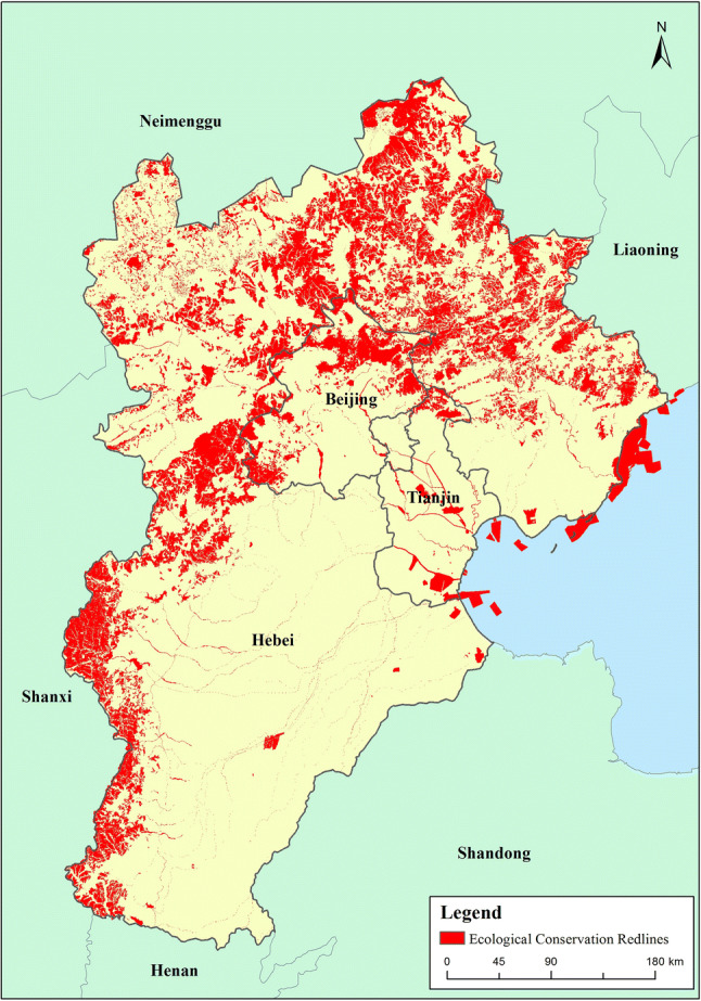
Distribution of ECR in Beijing–Tianjin–Hebei region
Fig. 3.

Distribution of ECR in Yangtze River economic zone
Fig. 4.

Distribution of ECR in Ningxia Hui Autonomous Region
In ECR delineation, coordination with local planning and local conditions is essential. The final determination of ECR is completed by local government through administrative power after coordination with various kinds of planning within the jurisdiction based on scientific delineation. The final ECR distribution results are issued by the provincial governments.
Shanghai provides a comprehensive example of ECR delineation. After assessment, land areas delivering important ecosystem services such as biodiversity conservation, water conservation, and soil and water conservation have areas of 1477, 298 and 158 km2, respectively. Land areas with significant environmental such as salinization and soil and water erosion have the areas of 274 and 154 km2, respectively. Combined with zones where development is prohibited including natural reserves, national forest parks, national geological parks, national wetland parks, and first-grade water source conservation areas, as well as the other ecological protection areas such as important wetlands and habitats of species with extremely small populations, the preliminary scope for ECR is 2731 km2 through comprehensive superposition. On this basis, urban space, agricultural space, independent small patches (< 1 km2), and other inadaptable areas are deducted to obtain ECR. After integration with the existing planning, the final area within the Shanghai ECR is 2083 km2 (accounting for 11.84% of the city’s total area). The ECR covers more than 80% of the important habitats highlighted by the Yangtze River Estuary Wetland, including the habitats of all existing protected species in the city, such as Hydropot, Alligator sinensis, and 79 kinds of birds. It also protects all centralized water sources, benefitting 25 million people. The ECR thus effectively guarantees the bottom line of Shanghai’s ecological safety (SPG 2018).
Another example is Yunnan province, which has allocated 30.90% of its land area into ECR (PGYP 2018). The delineation of ECR has strengthened the protection of more than 90% of the typical ecosystems and more than 85% of the important species in the province, and encloses about 70% of the upper reaches of six major river systems, especially the Jinsha River, Nujiang River, Lancang River, and Ayeyarwady River, and key protection areas of the nine plateau lakes. This will maintain the water conservation function of the upper reaches of big rivers and ensure the drinking water safety for about 80% of the urban population in the province. The ECR delimitation promotes the intensive and economical use of various resources and provides ecological support for sustainable economic and social development (PGYP 2018).
And Sichuan province has delimited 30.45% of its land area under ECR designation (PGYP 2018). It involves about 80% of herbaceous wetlands and lake wetlands area and more than 60% of forest ecosystem area (PGSP 2018). Over 60% of water conservation function, 50% of water and soil conservation function, and 95% of species resources of the whole province are effectively protected by ECR (PGSP 2018).
Experience to date suggests that implementing the borders of ECR, formulating supporting policies, and establishing effective management systems are urgently needed. Chinese government has clearly defined ECR as the foundation and basis for all development and construction activities. This has improved the effectiveness of protection combined with the integrated monitoring and control system and strict supervision and management (SC 2011; He et al. 2018).
The delimitation of ECR by local governments gives them authority to prohibit arbitrary exploitation and construction which they consider would have a negative impact on economic development. So the coordination with economic development may limit the ECR delineation to some extent. Moreover, the area of some important landscapes delivering ecosystem services is relatively large, sometimes including the existing industrial and mining enterprises, transportation lands, and other lands for artificial construction; it is difficult to withdraw these economically important lands from their current uses.
Future perspectives for ECR determination
Much of the policy discourse on the need for valuation of nature’s contributions to people relies on either a utilitarian economic perspective or an environmental ethics stance of nature–human relationships (Pascual et al. 2017). ECR draws from both of these perspectives by meeting the needs of environmental protection while promoting the long-term sustainable development of the local economy. For example, Anji County in Zhejiang province was the first ECR delimitation area in China. After ECR was determined, the one-year strict management enabled the standard-reaching rate of surface water monitoring section and centralized drinking water source quality to reach 100%, with the good air quality rate 90.8%, up 4.3% over the same period in the previous year (Xinhua 2017). The continuous environmental improvement and natural resources distribution have encouraged the re-planning of the village, allowing it to become the first national ecological county and a “Beautiful Countryside” model that attracts many non-polluting enterprises and even the world’s top 500 enterprises to invest and settle down there. In addition, ECR delineation has renewed the industrial structure, transforming polluting industries to “green economy” approaches like eco-agriculture or eco-tourism. In 2018, the per capita income of farmers reached RMB 30 541 Yuan, 4.34 times more than that in 2005 (ACBS 2010; ACPG 2019).
Some people are concerned that the ECR is a “forbidden zone” or “non-people land” which doesn’t allow any implementation of human activities and projects. From the perspective of protection and utilization, ECR is indeed an extremely important, sensitive, and protection-needed area which must be “strictly controlled.” In the ECR management currently being formulated, a list of dos and don’ts is specified. After the introduction of the management, human activities within ECR should be in strict accordance with the activity list and management requirement, under which those already existent can be carried forward as before. If some restricted activities make regional development lag behind, “reasonable compensation” would fall into place.
Many ECR areas are located in remote mountainous zones suffering from inconvenient transportation, difficult development and construction, and severe poverty. The eco-compensation brought about by ECR delineation can help improve the income of the local poor. In addition, the “scientific utilization” of ECR can transform ecological advantages into economic edges in places like Anji. How to take advantage scientifically of ECR according to local conditions will be the focus of future research. It follows that, rather than restrict the local economy, ECR aims to serve as the most solid foundation of sustainable development in the long run. After ECR delineation, it can both improve the quality of the local environment quality and promote grass and forest coverage which can be rationally utilized to develop ecological tourism and many sidelines. In this way, the ecological environment is maintained, and clean waters and lush mountains become invaluable assets.
Since ECR policy addresses relatively large areas, the management of ECR often faces greater challenges than do the smaller protected areas. But compared with traditional PAs, ECR has three important characteristics in terms of ecological conservation. First, for the protection of key species and habitats, ECRs include regions with important ecological functions and ecologically fragile areas that contribute to a more complete PA system. Second, in terms of the scope of conservation, compared with the relatively small nature reserves, the entire important ecological PAs are placed in ECR using scientific evaluation, in which the scope of conservation is expanded from fragmented “spots” to continuous “landscapes,” providing more complete and significant ecosystem conservation. Third, more stringent conservation through ECR ensures the permanent conservation of important ecological areas which cannot be converted to farmland, towns, and mines. Therefore, China’s ECR could be used as a reference for the design and development of an international nature conservation system in the future, to protect the integral natural ecosystems, bring benefits to future generations, and achieve the goal of sustainable development.
As a relatively new environmental policy at the national level, ECR currently focuses on its delineation outcomes, coordination among local authorities, and the technical specifications of surveying and mapping. ECR delineation outcomes are being optimized, the research on designation technical specifications has made headway, and the technical specifications have been issued (MEE 2019). The plan of the Chinese government stipulates that ECR will be demarcated by 2020, after which their management and maintenance will come to the fore. It will become the main direction of future research to explore the interaction and evolution mechanism between nature environment and the living environment, quantitatively evaluate the ecological protection effect, improve the research on eco-compensation methods, and identify the positive and negative effects of human activities within ECR for effective and informed guidance of human activities.
The current top-level design expects that 2 400 000 km2 will be delimited by ECR, strictly protecting nearly one-quarter of the terrestrial area of China (CPC and SC 2018). The completed system of ECR will protect more than 95% of China’s most valuable ecosystems, 100% of animal and plant habitats under state key conservation, 95% of the best natural landscape resources, 210 important river source areas, and all ecologically fragile and important areas of ecological function, which will greatly improve China’s ecological security.
Conclusion
Delimiting and strictly observing ECR has become a new strategy for ecological conservation with Chinese characteristics (Sang and Axmacher 2016). The core of the new strategy lies in controlling important ecological spaces by designing ECR that cannot be encroached and agreeing one map of national ecological conservation. By delineation, ECR complements the existing PA systems and expands from protecting biodiversity and natural landscapes to protecting ecosystem structure and function. The important ecologically functional, sensitive, and vulnerable areas are also included in the protected lands so that the national protection system is more complete.
So far, three regions including 15 provinces have finished ECR delimitation in China. The total area is 610 000 km2, accounting for about 1/4 of their total area. However, the coordination with economic development in the delineation process limits ECR results. In addition, some important ecological functional areas are relatively large, including existing industrial and mining enterprises, transportation lands, and other lands for artificial construction, which are difficult to withdraw from the ecological function areas in a timely manner. These hinder ECR delineation.
The Chinese government has clearly defined ECR as the foundation and basis for all development and construction activities, representing an institutional innovation for nature conservation. The improvement in effectiveness of protection has been gained through combination with the integrated monitoring and control system and strict supervision and management. The strategy will play a key role in nature conservation in China and may also inspire other countries to adopt similar approaches for a more productive relationship between natural ecosystems and sustainable development.
Acknowledgements
This work was jointly supported by the National Key Research and Development Program of China (2017YFC0506606) and the Municipal Natural Science Foundation (BK20170112). We are very grateful to Dr. Jeffrey A. McNeely for going to great lengths in revising the language.
Biographies
Jixi Gao
is the chief expert of the National Ecological Conservation Redline (ECR) Expert Committee of China and the chief executive for delimiting ECR. His work focuses on regional ecological protection. He is the initiator and chief expert for the management of ECR in China and has high academic achievements in this field. He first proposed the concept of ECR in 2000 and then established a technological system for them, which has been used to protect and control important ecological spaces in China. He presides over the delimitation of ECR for the entire country and has formulated the top-level design of ECR nationally.
Yan Wang
is an associate research fellow of Nanjing Institute of Environmental Sciences, Ministry of Ecology and Environment of the People’s Republic of China. Her expertise is delimitation and management of ECR, ecosystem services, and ecological asset assessment. She has produced more than 30 peer-reviewed publications.
Changxin Zou
is the director of Department of Ecological Protection and Climate Change Response of Nanjing Institute of Environmental Sciences, Ministry of Ecology and Environment of the People’s Republic of China. His interests include delimitation and management of ECR, ecological conservation and restoration, and regional ecological security assessment and early warning. He is the head of the Technical Team of the Ministry of Ecology and Environment leading group office for ecological conservation redline delimitation.
Delin Xu
is an associate research fellow of Nanjing Institute of Environmental Sciences, Ministry of Ecology and Environment of the People’s Republic of China. Her interests include ecosystem services assessment, ecological security pattern construction, and ecological system structure research.
Naifeng Lin
is a senior engineer of Nanjing Institute of Environmental Sciences, Ministry of Ecology and Environment of the People’s Republic of China. His interests include ECR demarcation and management, regional climate change research, and geographic information systems and remote sensing applications.
Lixia Wang
is a senior engineer of Satellite Environment Center, Ministry of Ecology and Environment of the People’s Republic of China. Her interests include delimitation of ECR, ecosystem services assessment, and geographic information systems and remote sensing applications.
Kun Zhang
is an assistant researcher fellow of Nanjing Institute of Environmental Sciences, Ministry of Ecology and Environment. His interests include ECR delineation, ecosystem services assessment, and ecological restoration assessment.
Footnotes
Publisher's Note
Springer Nature remains neutral with regard to jurisdictional claims in published maps and institutional affiliations.
Contributor Information
Jixi Gao, Email: gjx@nies.org, Email: gaoeco@163.com.
Yan Wang, Email: wangyan@nies.org.
Changxin Zou, Email: zcx@nies.org.
Delin Xu, Email: xudelin11@163.com.
Naifeng Lin, Email: linkaola_1986@163.com.
Lixia Wang, Email: wanglixia2034@163.com.
Kun Zhang, Email: zhangkun@nies.org.
References
- Anji County Bureau of Statistics (ACBS). 2010. National economic and social development statistical bulletin of Anji County in 2005. Retrieved September 14, 2018, from http://www.tjcn.org/tjgb/11zj/7118_2.html. (in Chinese).
- Anji County People’s Government (ACPG). 2019. National economic and social development statistical bulletin of Anji County in 2018. Retrieved September 28, 2019, from http://www.anji.gov.cn/zwgk/tjsj/ndsj/20190604/i2424319.html. (in Chinese).
- Bai Y, Jiang B, Wang M, Li H, Alatalo JM, Huang S. New ecological redline policy (ERP) to secure ecosystem services in China. Land Use Policy. 2016;55:348–351. doi: 10.1016/j.landusepol.2015.09.002. [DOI] [Google Scholar]
- Bai Y, Wong C, Jiang B, Hughes AC, Wang M, Wang Q. Developing China’s Ecological Redline Policy using ecosystem services assessments for land use planning. Nature Communications. 2018;9:3034. doi: 10.1038/s41467-018-05306-1. [DOI] [PMC free article] [PubMed] [Google Scholar]
- Barral MP, Oscar MN. Land-use planning based on ecosystem service assessment: A case study in the Southeast Pampas of Argentina. Agriculture, Ecosystems & Environment. 2012;154:34–43. doi: 10.1016/j.agee.2011.07.010. [DOI] [Google Scholar]
- Burmatova OP. Nature conservation strategy for regional socioeconomic development. Regional Research of Russia. 2015;5:286–297. doi: 10.1134/S207997051503003X. [DOI] [Google Scholar]
- Cao S. Why large-scale afforestation efforts in China have failed to solve the desertification problem. Environmental Science and Technology. 2008;42:1826–1831. doi: 10.1021/es0870597. [DOI] [PubMed] [Google Scholar]
- Chang Q, Liu X, Wu J, He P. MSPA-Based urban green infrastructure planning and management approach for urban sustainability: Case study of Longgang in China. Journal of Urban Planning & Development. 2014;141:A5014006. [Google Scholar]
- Communist Party of China (CPC) Central Committee and the State Council (SC). 2018. Opinions of the Central Committee of the Communist Party of China and the State Council on comprehensively strengthening ecological and environmental protection and resolutely fighting pollution prevention and control. Retrieved September 14, 2018, from http://www.gov.cn/zhengce/2018-06/24/content_5300953.htm. (in Chinese).
- de Groot R, Wilson MA, Boumans RM. A typology for the classification, description and valuation of ecosystem functions, goods and services. Ecological Economics. 2002;41:393–408. doi: 10.1016/S0921-8009(02)00089-7. [DOI] [Google Scholar]
- Fan X, Li Y, Jiao Y. Ecological benefits analysis of the ecology red-line areas in Kunming District before and after changing the non-ecological use lands into ecological ones. Research of Soil and Water Conservation. 2008;15:179–188. [Google Scholar]
- Fox JL, Dhondup K, Dorji T. Tibetan antelope Pantholops hodgsonii conservation and new rangeland management policies in the western Chang Tang Nature Reserve, Tibet: is fencing creating an impasse? Oryx. 2009;43:183–190. doi: 10.1017/S0030605308001774. [DOI] [Google Scholar]
- Fu B, Lü Y, Gao G. Major research progresses on the ecosystem service and ecological safety of main terrestrial ecosystems in China. Chinese Journal of Nature. 2012;5:261–272. [Google Scholar]
- Hao T, Xu J, Zhang L. Chinese environmental economy policy and the preferential policy of reforestation and revegetation. Chinese Agricultural Science Bulletin. 2005;21:349–363. [Google Scholar]
- He P, Gao J, Zhang W, Rao S, Zou C, Du J, Liu W. China integrating conservation areas into red lines for stricter and unified management. Land Use Policy. 2018;71:245–248. doi: 10.1016/j.landusepol.2017.11.057. [DOI] [Google Scholar]
- Lei G, Zeng Q. Perspectives on national parks: enlightenment from the development of global nature conservation. Biodiversity Science. 2014;22:423–424. doi: 10.3724/SP.J.1003.2014.14124. [DOI] [Google Scholar]
- Li S. Comparison on conversion of cropland to forest and grassland in the world. World Forestry Research. 2002;15:22–27. [Google Scholar]
- Li G, Li X, Wang H. Ecological compensation effect of national key ecological function area’s transfer payment policy. Modern Economic Science. 2013;35:58–64. [Google Scholar]
- Liang J, He X, Zeng G, Zhong M, Gao X, Li X, Li X, Wu H, et al. Integrating priority areas and ecological corridors into national network for conservation planning in China. Science of the Total Environment. 2018;626:22–29. doi: 10.1016/j.scitotenv.2018.01.086. [DOI] [PubMed] [Google Scholar]
- Liu Y. Say “no” to encroaching on ecological space. Land Resources. 2004;2:12–13. [Google Scholar]
- Liu G, Yang Z, Chen B, Zhang L, Zhang Y, Su M. An ecological network perspective in improving reserve design and connectivity: A case study of Wuyishan Nature Reserve in China. Ecological Modelling. 2015;306:185–194. doi: 10.1016/j.ecolmodel.2014.10.004. [DOI] [Google Scholar]
- Liu D, Lin N, Zou C, You G. Development of foreign ecological protected areas and linkages to ecological protection redline delineation and management in China. Biodiversity Science. 2015;23:708–715. doi: 10.17520/biods.2015131. [DOI] [Google Scholar]
- Lü, Y., L. Zhang, Y. Zeng, B. Fu, C. Whitham, S. Liu, and B. Wu. 2017. Representation of critical natural capital in China. Conservation Biology 31: 894–902. [DOI] [PubMed]
- Ming D, Yan Z, Li G. Temporal and spatial characteristics of the water pollutant concentration in Huaihe River Basin from 2003 to 2012. China. Environmental Monitoring & Assessment. 2016;188:522. doi: 10.1007/s10661-016-5503-0. [DOI] [PubMed] [Google Scholar]
- Ministry of Ecological and Environment of the People’ Republic of China (MEE). 2019. Issue on the technical regulations on surveying and mapping of borderline of ECR. Retrieved September 28, 2019, from http://www.mee.gov.cn/xxgk2018/xxgk/xxgk05/201909/t20190910_733265.html. (in Chinese).
- Ministry of Environmental Conservation (MEP). 2018. China environmental status bullet in 2017. Retrieved September 28, 2019, from http://www.gov.cn/guoqing/2019-04/09/content_5380689.htm. (in Chinese).
- Ministry of Environmental Conservation of China, Chinese Academy of Sciences (MEP and CAS). 2014. Survey and assessment of national ecosystem changes between 2000 and 2010, China. (in Chinese).
- Ministry of Environmental Conservation of China, National Development and Reform Commission (MEP and NDRC). 2017. Technical guidelines for the delimitation of ecological conservation redlines. Retrieved September 14, 2018, from http://www.mee.gov.cn/gkml/hbb/bgt/201707/W020170728397753220005.pdf. (in Chinese).
- Mu S, Zhou K, Fang Y, Zhu C. The need and the prospects for developing large-scale green corridors to protect biodiversity. Biodiversity Science. 2014;22:242–249. doi: 10.3724/SP.J.1003.2014.13188. [DOI] [Google Scholar]
- National Bureau of Statistics Research Group (NBSRG) The impact of “farmland re-turning into forest” upon grain production, supply and demand in west China. Management World. 2004;11(97–100):108. [Google Scholar]
- National Development and Reform Commission (NDRC and NTA). 2016. National ecological tourism development plan (2016–2025). Retrieved September 14, 2018, from http://www.gov.cn/gongbao/content/2017/content_5194900.htm. (in Chinese).
- Pacheco L, Fraixedas S, Fernández LÁ, Estela N, Mominee R, Guallar F. Perspectives on sustainable resource conservation in community nature reserves: A case study from Senegal. Sustainability. 2012;4:3158–3179. doi: 10.3390/su4113158. [DOI] [Google Scholar]
- Pascual U, Balvanera P, Díaz S, Pataki G, Roth E, Stenseke M, Watson RT, Dessane EB, et al. Valuing nature’s contributions to people: The IPBES approach. Current Opinion in Environmental Sustainability. 2017;26–27:7–16. doi: 10.1016/j.cosust.2016.12.006. [DOI] [Google Scholar]
- Prople’s Government of Yunnan Province (PGYP). 2018. Interpretation of Yunnan ecological conservation redline. Retrieved September 14, 2018, from https://www.ynmh.gov.cn/files/2019/10/20191021082757951.pdf. (in Chinese).
- Prople’s Government of Sichuan Province (PGSP). 2018. Notice of Sichuan provincial people’s government on the issuance of the ecological conservation redline plan. Retrieved September 14, 2018, from http://www.sc.gov.cn/10462/10464/10797/2018/7/25/10455723.shtml. (in Chinese).
- Ren C, Wang L, Zheng B, Qian J, Ton H. Ten-year change of total phosphorous pollution in the Min River, an upstream tributary of the Three Gorges Reservoir. Environmental Earth Sciences. 2016;75:1–11. doi: 10.1007/s12665-015-4873-x. [DOI] [Google Scholar]
- Sang WG, Axmacher JC. China draws lines to green future. Nature. 2016;531:305–305. doi: 10.1038/531305b. [DOI] [PubMed] [Google Scholar]
- Shanghai Municipal People’s Government (SPG). 2018. Delimitation of ECR in Shanghai. Retrieved September 14, 2018, from http://wap.sh.gov.cn/nw2/nw2314/nw2319/nw12344/u26aw56305.html. (in Chinese).
- State Forestry Bureau (SFU). 2015. Bulletin about the fifth desertification and sandification situation in China. China Green Times. 2015-12-30.
- Su, Y. 2004. Which certification is the best for a natural heritage? Market Daily. Feb 9. pp. 15. (in Chinese).
- The Central People’s Government of the People’s Republic of China (CGP). 2017. Opinions on the delimitation and adherence to the ecological protection redlines. Retrieved September 14, 2018, from http://www.gov.cn/gongbao/content/2017/content_5174504.htm. (in Chinese).
- The State Council (SC). 2011. Notice of State Council about printing the plan of national main functional area. Retrieved September 14, 2018, from http://www.gov.cn/zwgk/2011-06/08/content_1879180.htm. (in Chinese).
- UNEP-WCMC and IUCN. 2016. Protected Planet Report 2016. UNEP-WCMC and IUCN, Cambridge, UK, and Gland, Switzerland.
- United Nations . The value of forests: Payments for ecosystem services in a green economy. Geneva: UNECE; 2014. [Google Scholar]
- Wang C, Sun G, Dang L. Identifying ecological red lines: A case study of the coast in Liaoning Province. Sustainability. 2015;7:9461–9477. doi: 10.3390/su7079461. [DOI] [Google Scholar]
- Wang W, Tian Y, Chang M, Li J. A review of transboundary protected areas network establishment. Acta Ecologica Sinica. 2014;34:1391–1400. [Google Scholar]
- Wang Y, Gao J, Zou C, Xu D, Wang L, Jin Y, Wu D, Lin N, et al. Identifying ecologically valuable and sensitive areas—A case study analysis from China. Journal for Nature Conservation. 2017;40:49–63. doi: 10.1016/j.jnc.2017.08.005. [DOI] [Google Scholar]
- Wang Y, Gan Y, Fei D, Tai F. Study on restoration effects of enclosed pasture in pastureland rehabilitation areas in northwestern Sichuan province. Pratacultural Science. 2008;25:15–19. [Google Scholar]
- Weeks R, Adams VM. Research priorities for conservation and natural resource management in Oceania’s small-island developing states. Conservation Biology. 2017;32:72–83. doi: 10.1111/cobi.12964. [DOI] [PubMed] [Google Scholar]
- World Wide Fund for Nature (WWF). 2016. Living planet report 2016. Retrieved September 14, 2018, from https://www.worldwildlife.org/pages/living-planet-report-2016.
- Xinhua. 2017. “Protect ecology like eyes” – Zhejiang has designated more than 700 “redline zones” to build “high-voltage lines” for ecological protection. Retrieved September 14, 2018, from http://www.xinhuanet.com/local/2017-02/20/c_1120497612.htm. (in Chinese).
- Yan S, Zhang H, Li H, Tang H. Ecosystem service values of the entire land area and ecological redlines in Jiangsu Province. Acta Ecologica Sinica. 2017;37:4511–4518. [Google Scholar]
- Yan W, Li H, Meng W. European and American ecological network planning enlightenment to China’s. Environmental Protection. 2010;18:64–66. [Google Scholar]
- Yang S, An Y, Wang P, Ma L, Hu F, Sun Q. Study of ecological red-line zones in Guizhou Chishui River Basin. Resources and Environment in Yangtze Basin. 2016;24:1405–1410. [Google Scholar]
- Yang M, Fang Z, Xie Q, Wang M, Wang P. Rapid evaluation on the ecological service benefits according ecological red line drawing during urbanization. Resources and Environment in the Yangtze Basin. 2015;24:1–8. [Google Scholar]
- Zhao G, Liu J, Kuang W, Ouyang Z. Disturbance impacts of land use change on biodiversity conservation priority areas across China during 1990-2010. Journal of Geographical Sciences. 2015;25:515–529. doi: 10.1007/s11442-015-1184-9. [DOI] [Google Scholar]