Abstract
The present work aims to investigate seasonal variations in air pollution levels in Lucknow and assess the ambient air quality of the city together with highlighting the health impacts of major pollutants like PM10, PM2.5, SO2, NO2, Pb, Ni and aerosols from 2010 to 2019. The maximum and minimum values of PM10, PM2.5, SO2, NO2, Pb and Ni were found to be 270.75 and 122.45 μg/m3, 124.95 and 95.52 μg/m3, 25.60 and 8.05 μg/m3, 75.65 and 23.85 μg/m3, 0.66 and 0.03 μg/m3 and 0.07 and 0.01 ng/m3, respectively. Health impact of particulate matter has also been assessed with AirQ+, and it was estimated that long-term exposure of PM10 was attributed to between 37 and 48% for post-neonatal (age 1–12 months) mortality rate due to all causes, whereas long-term attributable proportions in mortality due to exposure of PM2.5 were to about 19 to 28% from all causes. Further, an attempt has also been made to evaluate the impact of lockdown amid COVID-19 on the ambient air quality of Lucknow. During the lockdown, PM2.5 levels reduced by 65% (at Gomti Nagar), 23% (at central school), 79% (at Lalbagh) and 35% (at Talkatora), due to which, air quality index of Gomti Nagar came down to 43, well below 50 which falls in the healthy range. NO2 levels also came down. However, levels of SO2 did not show significant reduction. Correlating the data between aerosol optical depth and Angstrom exponent by Pearson correlation analysis revealed a significant positive correlation (r = 0.65, P < 0.001).
Keywords: Air pollution, Aerosol, AirQ+, Lockdown, AQI, Health effect
Introduction
Infamous for being one of the most polluted cities in the world, Lucknow, the capital city of Uttar Pradesh, has witnessed unprecedentedly high levels of air pollution over the past few years. Clean air should be an unlimited free natural resource and the basic need of all living beings. Against a daily requirement of 2 kg of food and 3 L of water, an adult inhales and exhales about 8 L of air every single minute. But when this life-sustaining air gets polluted, it can have dire effects not only on humans but also on plants, animals and all living organisms (Ghorani-Azam et al. 2016). Today, the air we breathe is being polluted by various natural and anthropogenic sources like accelerated industrialization, haphazard urbanization, rapid increase in human population and ever-burgeoning number of automobiles on the roads (Satterthwaite et al. 2010). Natural processes absorb these pollutants to a certain extent and air quality is restored, but when the limits are exceeded, pollutants accumulate in the environment and air quality deteriorates. As per WHO data of 2006, more than 80% of urban dwellers are exposed to air quality levels that exceed WHO guideline limits (WHO 2006). However, as per recent 2016 data of WHO, it has now been observed in 90% of total world population (WHO 2016). Over the past few decades, human involvement has drastically modified Earth’s chemistry and climate. The emissions from automobiles, prolific burning of fossil fuels, industrial activities and intensification of agricultural practices have escalated the ambient concentration levels of harmful gases like SO2, NO2 and CO and of O3 and particulate matter (PM) to worrying levels (Gurjar et al. 2016; Wu et al. 2020). Effect of SO2 on ecosystem and human health is well known. Short-term exposure harms the respiratory system, particularly in children and elderly people (Pandey et al. 2011, 2013). It reacts with other gaseous particles in the air to form haze and thereby reduces visibility. Longer exposures to elevated concentrations of SO2 can aggravate existing heart and lung diseases. Epidemiological studies associate NO2 and CO with increased cardiovascular mortality, cerebrovascular diseases and ischaemic heart diseases (Atkinson et al. 2018). High concentration of CO in air reduces oxygen supply to critical organs like heart and brain, causing dizziness, unconsciousness and even death. As per the Indian Nitrogen Assessment report 2018, between 1991 and 2001, NOx emissions grew at 52% and at 69% from 2001 to 2011 (Pathak and Bhatia 2018). The sources of heavy metals in urban air include vehicular exhaust, untreated industrial effluents, street dust and other anthropogenic activities. Elevated concentrations of all the metals are harmful to living organisms. Though there are various routes by which these metals can enter inside the body, inhalation of particles (≤ 10 μm) is the commonest (Winkler et al. 2018; Zhang and Batterman 2013). The inorganic components constitute only a small portion by mass of the particulates; however, they contain some toxic elements which are potential carcinogens even in trace amounts (Shukla et al. 2008).
There is not an iota of doubt in the fact that deteriorating environment with worsening air quality, damaged landscapes and degraded towns would cost us dearly not only in economic terms but also in terms of our physical health and quality of life (Seinfeld and Pandis 1998). Lucknow, the state capital of Uttar Pradesh, was ranked as the ninth most polluted city in the world, as per the report published in March 2019. Within a very short period of time, the city could face serious problems if sincere efforts are not made to regulate and control pollution. There is, therefore, an urgent need to undertake proper carrying capacity studies and planned development of the city.
The use of clean fuel with low sulphur content is considered an effective measure to arrest the rising level of pollution in urban areas (Markandeya et al. 2016a, b). Prompted by the deteriorating air quality in Indian cities like Lucknow, the government has launched several flagship initiatives including implementation of stringent emission norms, strict pollution control measures, improved technology for combustion engines and phasing out of polluting 2-stroke engines. The government has also introduced compressed natural gas (CNG) in public transport system, which is 50% cleaner than coal on carbon emissions and significantly cleaner on SOx and NOx and has virtually non-existent PM2.5. Despite these efforts, vehicular pollution continues to remain the primary source of increasing air pollution in Lucknow City (Barman et al. 2008; assessment report CSIR-IITR 2010–2019), leading to generation of a vast amount of PM, noxious gases and heavy metals that push the pollution in the city to unbearable levels.
Atmospheric aerosols consist of solid or liquid particles suspended in the atmosphere and include a wide range of phenomena such as dust, smoke, haze, fume, smog, fog and mist (Seinfeld and Pandis 1998; Markandeya et al. 2017). PM refers just to the suspended solid or liquid matter, whereas an aerosol is a collection of suspended particles and the surrounding gases. Aerosols are produced from a variety of anthropogenic and natural sources with a typical size ranging from 0.001 to 10 μm. Natural aerosol particle includes sulphate aerosols from volcanic eruption, sea salt particle from ocean surface, mineral dust aerosols and wind borne dust (Shen et al. 2019; You et al. 2020). Aerosol loading or the amount of aerosols in the atmosphere is usually quantified by mass concentration or by an optical measure, i.e. aerosol optical depth (AOD). Thus, AOD is the qualitative measure of extinction of solar radiation by aerosol scattering and absorption between the points of observation and top of the atmosphere (Kumar et al. 2019; Tiwari et al. 2014, 2015). Angstrom exponent (AE) is a qualitative indicator of aerosol particle size. Higher AE values are a reflection of the fact that fine-mode aerosols are dominating, while lower AE values indicate dominance of coarse-mode aerosols (Das and Jayaraman 2011). Due to coagulation, the size of fine-mode particles is altered, resulting in increasing aerosol loading under suitable atmospheric condition, thereby leading to an increase of the concentration of coarse-mode particles (Das et al. 2015). The Moderate Resolution Imaging Spectroradiometer onboard two Earth Observing System (EOS) Terra and Aqua satellites at an altitude of 705 km measures reflected solar radiance and terrestrial emission in 36 bands ranging from 0.4 to 14.4 μm wavelength with the different spatial resolutions of 0.25 and 1 km (Gupta et al. 2013). All the above-mentioned facts necessitate the assessment of ambient air quality with respect to respirable suspended particulate matter (PM10 and PM2.5), SO2, NO2, metals (lead (Pb) and Ni) and aerosols in Lucknow City area. In this study, we observed long-term temporal and spatial variations of different ambient air pollutants and health impacts of particulate matters by using AirQ+ software. The study also investigates the impact of lockdown on the air quality of Lucknow City.
Materials and methods
Monitoring location
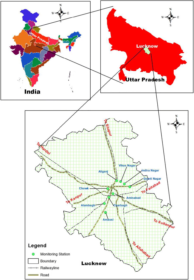
A total of nine air quality monitoring locations in different areas, i.e. four in residential (Aliganj, Indira Nagar, Vikas Nagar, Gomti Nagar), four in commercial cum traffic (Charbagh, Aminabad, Alambagh, Chowk) and one industrial area (Amausi) were selected for this study (Fig. 1).
Fig. 1.
Monitoring location of the study area in Lucknow City
Data collection
Air quality data
Particulate matters (PM10 and PM2.5) were measured using a gravimetric method, sulphur dioxide (SO2) was measured using the improved West-Gaeke method, nitrogen dioxide (NO2) was measured using the modified Jacobs-Hochheiser (Na-arsenite) method and trace metals (Pb and Ni) were measured using an AAS method after sampling on EPM 2000. Air quality data was obtained from our past Institute CSIR-IITR, Lucknow, which has the responsibility to assess the ambient air quality of Lucknow City in two phases: pre-monsoon (November to May, report released on June 5) and post-monsoon (June to October, report released on November 5). The sampling frequency was 24 hourly, twice in a month. Ten-year data from 2010 to 2019 was used in this study.
Data during lockdown
For assessment of day-to-day real-time air quality, a total number of four Continuous Ambient Air Quality Monitoring Stations (CAAQMS) have been installed in Lucknow. Out of these four stations, two CAAQMS are installed in residential areas, i.e. Gomti Nagar and Aliganj (central school). The remaining two have been installed in commercial and industrial areas, i.e. Lalbagh and Talkatora. To assess the impact of lockdown on the air quality, fortnight data before lockdown (February 21, 2020, to March 21, 2020) and during lockdown (March 22, 2020, to April 20, 2020) have been taken into consideration.
AOD and AE data
The remote sensing instrument called Moderate Resolution Imaging Spectroradiometer (MODIS) permits the scientist to monitor various characteristics of the Earth’s terrestrial and oceanic surfaces with a single instrument, also facilitating the analysis of aerosols from the space with maximum accuracy. AE and AOD datasets used in this study were retrieved from both MODIS Terra and Aqua satellites and downloaded from NASA Giovanni website (https://giovanni.gsfc.nasa.gov/giovanni/) of level 3 Collection 6.1, which is globally available with 1° × 1° resolution, and averaged values of the daily mean of area were employed in the range of latitude from 26.35 to 27.35° N and longitude of 80.45–81.45° E, centralized at Lucknow (26.85° N, 80.95° E) for the period January 2010 to March 2020. In the present study, AOD data at a wavelength of 550 nm and AE at 412 nm/470 nm over land are used as they are associated with major radiative effects and are close to the peak of solar spectrum.
Data analyses
Air quality data
Data was divided into three segments: first was residential area (Aliganj, Indira Nagar, Vikas Nagar and Gomti Nagar), second was commercial area (Charbagh, Aminabad, Alambagh and Chowk) and third was industrial area (Amausi). The data is collected from CSIR-Indian Institute of Toxicology Research as our Institute covers whole-year data, and published in the form of report as pre-monsoon (November to May) and post-monsoon (June to October). It is the whole-year data. The sampling frequency was twice in a month for 24 hourly. Data was summarized as average, minimum and maximum of the pre-monsoon and post-monsoon average data.
Lockdown data
A map of Lucknow has been digitized, and different layers, i.e. continuous air monitoring stations, major roads and railway lines, have been generated. Three criteria of pollutants (PM2.5, SO2 and NO2) have been selected, and their fortnight data before and during lockdown has been collected from the CAAQMS real-time data bank of Central Pollution Control Board (CPCB). Average values of all three pollutants have been calculated for before and during lockdown period. For air quality index (AQI), the methodology adopted by CPCB, the sub-index against each pollutant and the resultant AQI will be the maximum of these sub-indexes (AQI-CPCB 2020). The sub-index (Ip) is calculated for individual pollutants (Cp) based on ‘linear segment principle’ by using the following equation (Eq. (1)):
| 1 |
where BHI is the breakpoint concentration greater or equal to the given concentration, BLO is the breakpoint concentration smaller or equal to the given concentration, IHI is the AQI value corresponding to BHI and ILO is the AQI value corresponding to BLO; subtract one from ILO, if ILO is greater than 50, and finally, AQI is the max (Ip) (where p is 1, 2,…, n; n denotes pollutants).
In the present study, during AQI calculation at all 4 locations, it has been observed that every time the sub-index of PM2.5 was maximum compared to SO2 and NO2. Average pollutant data along with AQI values before and during lockdown were mapped to monitoring stations’ database, and spatial maps were generated in ArcGIS, version 10.7.1.
Data analysis between AOD and AE
Aerosol data was summarized as mean ± SD. AOD and AE groups were compared by one-way analysis of variance (ANOVA). Pearson correlation analysis was done to assess the association between AOD and AE datasets. The statistical software Origin (version 9.1) was used for the analysis of data (Markandeya et al. 2015).
Health effects
The AIRQ+ software developed by WHO, updated in 2018, was used for the estimation of health impact assessment of PM10 and PM2.5 in this study. Relative rise (RR) is the estimation of the magnitude of an association between exposure and disease. It indicates the probability of developing the disease in the exposed group relative to those who are not exposed. Probability is the ratio of developing the disease in the exposed group to that in the non-exposed group. It also indicates the probability of developing the disease in the exposed area at the given time period. Here, we assumed RR to be equal to 1.04 (95% CI = 1.02 to 1.07) for the neonatal age group at baseline PM10 (50 μg/m3). On the other hand, the RR taken for PM2.5 was 1.07 (95% CI = 1.05 to 1.09) for all causes of mortality at baseline PM2.5 (40 μg/m3).
RR is usually modelled with a log-linear function as given in Eq. (2)
| 2 |
where Xi is the pollutant concentration (μg/m3) and X0 is the cut-off or counterfactual (μg/m3). In the log-linear model, β is the change in the RR for a 1-unit change in the concentration Xi.
Results and discussion
Analysis of air quality data
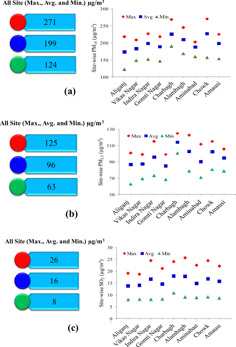
The maximum average values for PM10 and PM2.5 were 271 and 125 μg/m3, respectively, and the yearly average values of both these pollutants for the stated period (2010 to 2019) were 199 and 96 μg/m3, respectively (Fig. 2a, b). These are much higher than those prescribed by the National Ambient Air Quality Standards (NAAQS) (60 μg/m3 for PM10 and 40 μg/m3 for PM2.5). Area-wise, almost all the considered areas reported high particulate pollution, but two commercially important areas, namely Charbagh and Chowk, were worst affected. Charbagh had the highest values for both PM10 and PM2.5, where the average level was always higher than 199.33 μg/m3 for PM10 and 95.52 μg/m3 for PM2.5, much above the permissible limits.
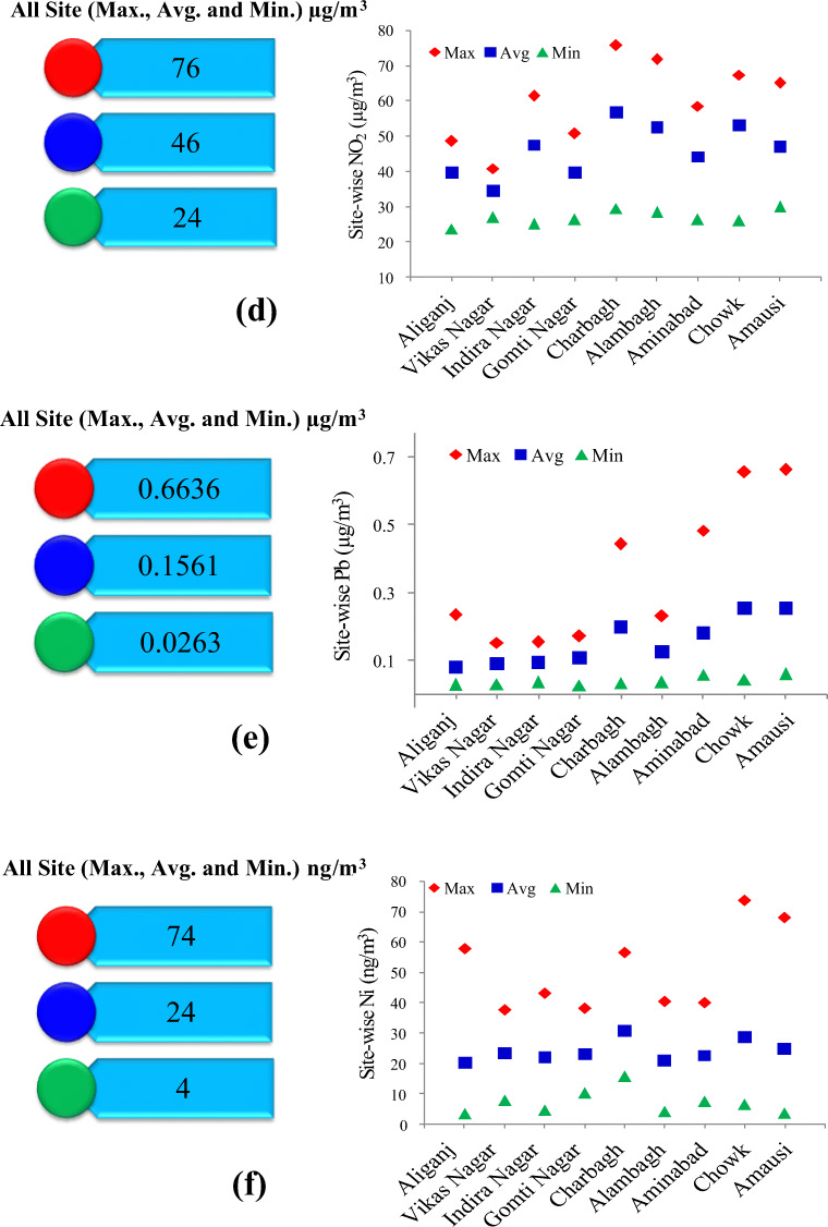
Fig. 2.
Variations of the concentration of pollutants (a PM10, b PM2.5, c SO2, d NO2, e Pb and f Ni) in air quality at different areas of Lucknow City
Since particulate matter is the dominant pollutant in most areas of the city, AQI values are directly linked to the level of particulate matter in the air. AQI values from 150 to 200 fall in the unhealthy category (CPCB 2006–2007). At such level of pollution, everyone may begin to experience health effects; especially, members of sensitive groups may experience more serious health problems, and active children and adults and people with a respiratory disease, such as asthma, should avoid prolonged outdoor exertion. Such high particulate pollution in Lucknow is in line with the findings of the IQ Air report (2019) which highlights that, on average, most Indian cities exceed the WHO guidelines for the amount of PM2.5 in the atmosphere by nearly 500% (IQAir report 2019).
Pollutants settle down on the ground with the raindrops. As a result, their level in the air decreases drastically during the monsoon season. From Table 1, it can be observed that post-monsoon PM10 levels were less than pre-monsoon levels for all the years from 2010 to 2019, with 2015 being the only exception. This may be due to the reason that 2015 was a strong El Nino year due to which there was much less rainfall during the south-west monsoon season. Less rain results in less scavenging of the pollutants from the atmosphere (Shukla et al. 2008).
Table 1.
Seasonal concentration of air pollutants
| Parameter | Location | 2010 | 2011 | 2012 | 2013 | 2014 | 2015 | 2016 | 2017 | 2018 | 2019 | ||||||||||
|---|---|---|---|---|---|---|---|---|---|---|---|---|---|---|---|---|---|---|---|---|---|
| Pre-M | Post-M | Pre-M | Post-M | Pre-M | Post-M | Pre-M | Post-M | Pre-M | Post-M | Pre-M | Post-M | Pre-M | Post-M | Pre-M | Post-M | Pre-M | Post-M | Pre-M | Post-M | ||
| PM10 (μg/m3) | Average of 4 residential locations | 155.9 | 129.1 | 181.7 | 167.2 | 216.3 | 167.1 | 205.8 | 178.2 | 209.1 | 192.4 | 182.5 | 195.3 | 201.4 | 180.9 | 223.6 | 192.0 | 201.9 | 208.2 | 180.1 | 154.0 |
| PM2.5 (μg/m3) | 68.0 | 68.9 | 69.6 | 94.8 | 88.3 | 83.5 | 90.0 | 97.1 | 88.4 | 83.5 | 90.0 | 97.1 | 100.8 | 91.0 | 107.5 | 96.1 | 93.7 | 103.2 | 85.2 | 79.3 | |
| SO2 (μg/m3) | 12.4 | 16.0 | 14.9 | 26.2 | 15.5 | 20.3 | 19.2 | 14.0 | 18.0 | 16.0 | 13.2 | 18.3 | 12.0 | 17.0 | 11.1 | 13.1 | 8.7 | 10.6 | 7.0 | 9.3 | |
| NO2 (μg/m3) | 27.6 | 23.9 | 27.0 | 38.5 | 32.8 | 48.4 | 41.9 | 49.7 | 36.4 | 48.0 | 43.3 | 55.4 | 39.5 | 54.1 | 46.9 | 46.8 | 37.8 | 44.2 | 34.0 | 32.2 | |
| Pb (μg/m3) | 0.1 | 0.1 | 0.1 | 0.1 | 0.1 | 0.1 | 0.1 | 0.1 | 0.2 | 0.1 | 0.1 | 0.1 | 0.1 | 0.1 | 0.2 | 0.2 | 0.1 | 0.1 | 0.1 | 0.1 | |
| Ni (ng/m3) | 14.8 | 16.0 | 21.9 | 8.6 | 13.9 | 45.8 | 14.9 | 10.2 | 43.3 | 31.5 | 17.1 | 17.5 | 37.3 | 47.9 | 41.1 | 15.3 | 8.8 | 13.9 | 3.1 | 19.4 | |
| PM10 (μg/m3) | Average of 4 commercial locations | 206.5 | 180.4 | 225.3 | 193.2 | 248.9 | 230.9 | 235.3 | 223.9 | 219.7 | 217.5 | 212.4 | 243.9 | 230.1 | 211.1 | 231.7 | 199.6 | 196.3 | 209.8 | 174.3 | 165.4 |
| PM2.5 (μg/m3) | 82.5 | 133.6 | 83.9 | 103.5 | 90.5 | 107.3 | 104.8 | 120.9 | 90.7 | 107.3 | 104.8 | 120.9 | 110.2 | 97.5 | 114.5 | 108.7 | 96.9 | 104.7 | 84.7 | 80.9 | |
| SO2 (μg/m3) | 14.0 | 19.3 | 16.8 | 31.4 | 19.6 | 22.6 | 21.1 | 17.4 | 20.3 | 18.5 | 14.6 | 21.9 | 13.4 | 21.3 | 11.8 | 14.3 | 10.3 | 10.8 | 8.1 | 11.0 | |
| NO2 (μg/m3) | 31.1 | 24.0 | 34.1 | 61.9 | 39.4 | 67.0 | 51.4 | 60.4 | 54.4 | 66.8 | 62.4 | 72.4 | 44.1 | 66.4 | 54.6 | 56.6 | 51.6 | 57.1 | 42.8 | 35.0 | |
| Pb (μg/m3) | 0.5 | 0.1 | 0.4 | 0.1 | 0.1 | 0.1 | 0.2 | 0.2 | 0.1 | 0.4 | 0.2 | 0.2 | 0.2 | 0.3 | 0.2 | 0.3 | 0.1 | 0.1 | 0.1 | 0.1 | |
| Ni (ng/m3) | 17.5 | 26.5 | 21.0 | 11.8 | 14.6 | 41.3 | 19.1 | 14.7 | 38.8 | 37.8 | 33.1 | 20.4 | 42.4 | 60.0 | 45.9 | 21.8 | 10.5 | 17.8 | 6.4 | 12.2 | |
| PM10 (μg/m3) | Average of industrial location: Amausi | 160.9 | 156.5 | 163.0 | 145.0 | 227.2 | 217.9 | 224.3 | 226.9 | 217.3 | 186.6 | 199.4 | 214.2 | 238.3 | 212.9 | 210.1 | 203.1 | 196.9 | 223.3 | 189.2 | 153.7 |
| PM2.5 (μg/m3) | 66.0 | 136.0 | 67.6 | 90.0 | 87.0 | 85.2 | 96.9 | 114.3 | 87.1 | 85.2 | 96.9 | 114.3 | 111.3 | 99.6 | 106.3 | 94.4 | 89.4 | 107.7 | 79.8 | 80.1 | |
| SO2 (μg/m3) | 9.6 | 15.8 | 14.3 | 25.7 | 17.1 | 27.2 | 22.8 | 18.0 | 23.5 | 17.3 | 10.2 | 20.6 | 11.9 | 17.2 | 12.2 | 14.7 | 7.9 | 9.5 | 7.8 | 10.7 | |
| NO2 (μg/m3) | 37.6 | 22.4 | 29.0 | 48.8 | 46.8 | 48.3 | 55.9 | 49.9 | 39.6 | 70.6 | 54.4 | 75.5 | 45.3 | 55.6 | 47.6 | 41.3 | 41.7 | 50.5 | 29.8 | 49.7 | |
| Pb (μg/m3) | 1.0 | 0.1 | 0.4 | 0.1 | 0.1 | 0.2 | 0.8 | 0.5 | 0.2 | 0.1 | 0.1 | 0.2 | 0.1 | 0.2 | 0.5 | 0.1 | 0.1 | 0.2 | 0.1 | 0.1 | |
| Ni (ng/m3) | 7.4 | 10.9 | 15.7 | 4.9 | 12.1 | 41.0 | 23.7 | 14.8 | 41.0 | 20.0 | 17.8 | 18.3 | 36.9 | 98.9 | 46.8 | 52.3 | 9.5 | 16.8 | 2.4 | 4.7 | |
Pre-M pre monsoon, Post-M post monsoon
In contrast to all other considered pollutants, the levels of SO2 in commercial areas were not much different from those observed in residential and industrial areas. The commercial area of Alambagh reported higher average SO2 levels than Charbagh, Chowk and Amausi (Fig. 2c). Though the concentrations of SO2 reported from all the sampling stations are well below the prescribed NAAQS level (80 μg/m3), consistently high levels in the early post monsoon could be attributed to the stable meteorological conditions. Ghosh et al. (2018) also found that the concentration of SO2 was higher in post monsoon, which is similar to the present study.
Just like SO2, NO2 concentrations peaked during November to January and were minimum during July to August (Fig. 2c, d), possibly due to a large number of factors like low solar intensity resulting in decreased photochemical loss, anthropogenic emissions, boundary layer processes and local surface wind pattern. Similar observations have been reported from other urban locations like Ahmedabad and Pune, in India (Beig et al. 2013). For almost all the considered areas, the levels of NO2 were higher than 40 μg/m3 (NAAQS 2009). The silver lining is that the NO2 concentrations at Lucknow were still comparatively lower than those observed at other urban regions of the country.
Pollution levels in most regions of North India during the onset of winters reach unbearable levels, engulfing huge areas in thick smog, Lucknow being no exception. This is due to a combination of factors like increased biomass burning, festive season that culminates with the bursting of firecrackers on the night of Deepawali and a weather pattern which according to experts brings dust-bearing winds from West Asian countries like Iraq, Saudi Arabia and Kuwait. These winds collide with the moisture-bearing wind system coming from the east. Moisture locks in the dust and becomes a cloud. At the same time, there is no wind at the ground level. This creates suffocating conditions (Havens et al. 2018).
As a result of EPA’s regulatory efforts including the removal of Pb from motor vehicle gasoline, levels of Pb in the air decreased by 98% between 1980 and 2014 (Hai et al. 2018). Still high level of Pb pollution is an important issue in Lucknow. From Fig. 2e, it can be observed that the level of aerial Pb in commercial and industrial areas is almost double that of residential areas. Chowk and Amausi are the two main areas grappling with Pb pollution, where the recorded levels were as high as 0.664 μg/m3. These are higher than the NAAQS-prescribed limit of 0.5 μg/m3. The average value is 0.16 μg/m3, but since Pb as a pollutant has no known safe threshold (there is no known sufficiently small amount of Pb that does not cause harm).
Environmental Ni levels depend particularly on natural sources, pollution from nickel-manufacturing industries and airborne particles from combustion of fossil fuels (US EPA 1999). There was a huge variation observed between the highest and lowest average values of Ni, the former being as high as 74 ng/m3 and the latter 4 ng/m3 (Fig. 2f). The average value of 24 ng/m3 for the stated period of the study was higher than the permissible limit of 20 ng/m3 (NAAQS). Chowk and Amausi were the worst affected areas.
Data analysis before and during lockdown
Lockdown brought everything to a grinding halt, advocating blanket ban on all types of construction activities and restricting non-essential travels. As a result, vehicle density on the roads reduced drastically, ensuring a substantial drop in air pollution levels. Table 2 shows the comparison of the ambient air quality of Lucknow City before and after lockdown.
Table 2.
AQI before and during lockdown
| Locations | Before lockdown | During lockdown | ||||||
|---|---|---|---|---|---|---|---|---|
| Sub-index | AQI | Sub-index | AQI | |||||
| PM2.5 | SO2 | NO2 | PM2.5 | SO2 | NO2 | |||
| Gomti Nagar | 71 | 18 | 35 | 71 | 43 | 14 | 11 | 43 |
| Central School | 79 | 10 | 35 | 79 | 64 | 9 | 8 | 64 |
| Lalbagh | 213 | 5 | 30 | 213 | 119 | 5 | 20 | 119 |
| Talkatora | 174 | 4 | 35 | 174 | 129 | 4 | 15 | 129 |
Based on Eq. (1), AQI has been calculated for all the four locations before and during lockdown. The details of AQI values are given in Table 2.
In the present study during AQI calculation at all 4 locations, it has been observed that every time the sub-index of PM2.5 was maximum compared to SO2 and NO2. Average pollutant data along with AQI values before and during lockdown were mapped to monitoring stations’ database, and spatial maps were generated.
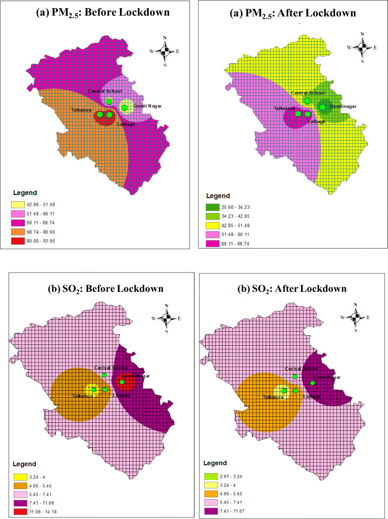
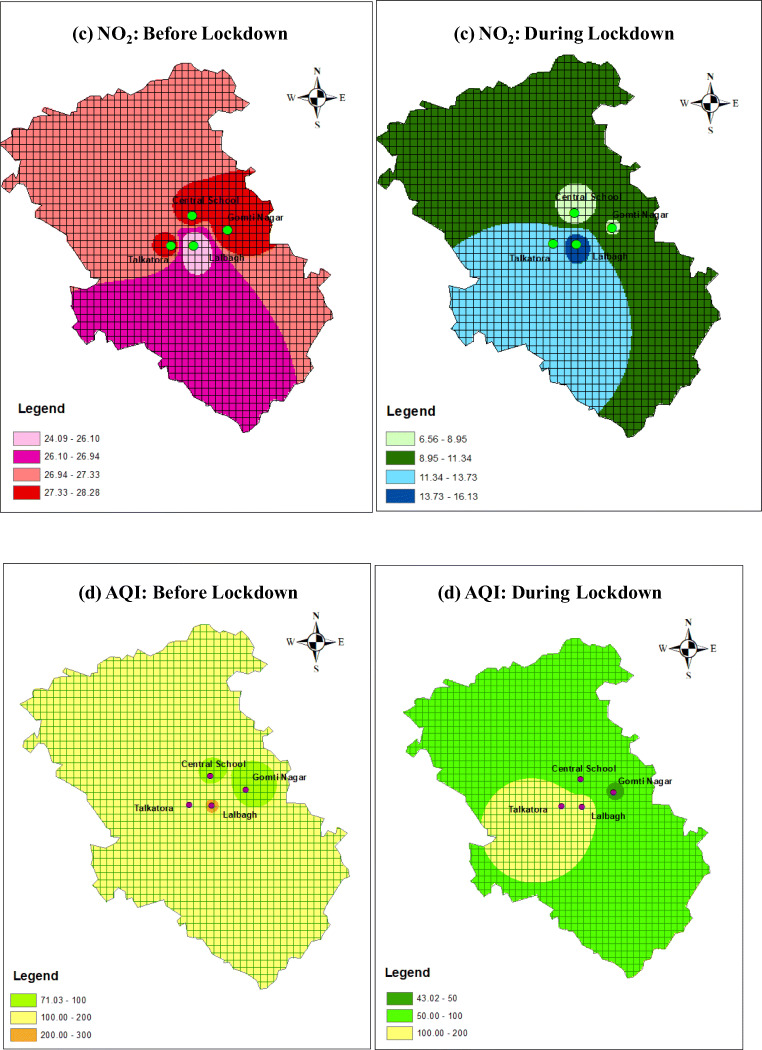
Figure 3a shows that, during lockdown, a gradual uniform reduction of PM2.5 has been observed at all locations, whereas from Fig. 3b, it can be observed that no such significant variation has been observed in values of SO2 before and during lockdown. Before lockdown, the values of NO2 were higher in residential areas compared to industrial areas (Fig. 3c). But during lockdown, NO2 values in residential areas were less than those in industrial areas. It may be due to the fact that, in residential areas, the major and prime source of NO2 is vehicular pollution. In high-traffic density areas, NO2 concentration was higher at all residential locations before lockdown, but during lockdown, all vehicular movements got suspended due to which a sharp decline was observed in the values of NO2. But in industrial area, the activity continued with little reduction of the man power. From Fig. 3d, it can be observed that, before lockdown, the major areas of Lucknow were severely and moderately polluted, whereas during lockdown, major areas of Lucknow had satisfactory air quality index.
Fig. 3.
Variations in PM2.5 (a), SO2 (b), NO2 (c) and AQI (d) in air quality before and during lockdown at different areas of Lucknow City
Relationship between AOD and AE values
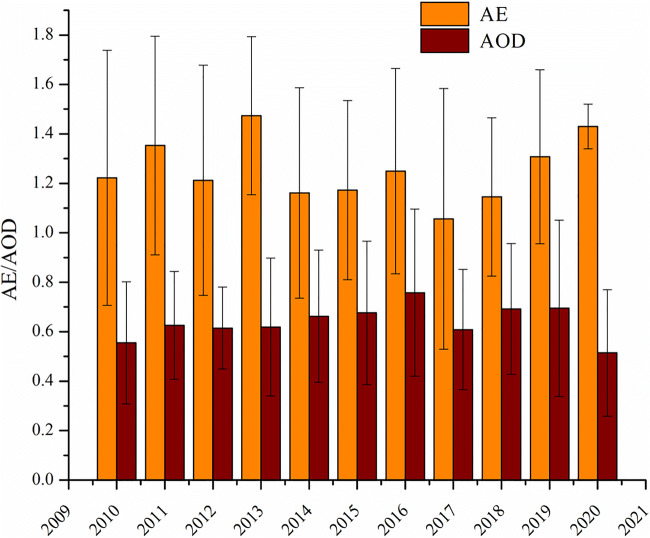
The spectral characteristics of AOD suggest about potential aerosol particles (course and fine) and their size distribution. The annual mean distribution of AOD and AE for the period of 2010 to 2019 over Lucknow City is presented in Fig. 4. The highest value of AOD was observed in 2016 while lowest was observed in 2010 with a range of 0.76 ± 0.34 to 0.56 ± 0.25. Tiwari et al. (2018) also reported nearly similar AOD value (0.64) over Kanpur City.
Fig. 4.
Annual variations of AOD550 nm and AE412–470 nm (annual mean AOD and AE are calculated by averaging all AOD and AE values for the same month during 2010 to 2019)
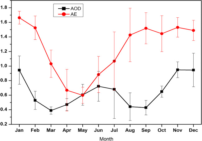
Srivastava et al. (2012) value was 0.63 ± 0.21, and the current study (with a value of 0.64) presented nearly similar results for annual average. Larger value of AOD in November, December and January may be due to high burning of biomass/agriculture residue and atmospheric condition, while in June and July, it may be due to less data availability of AOD due to cloud interference and water-absorbing type of aerosols. Analysis showed that the highest monthly mean value of AOD was found in the month of November (0.95 ± 0.11) and December (0.95 ± 0.23) followed by January (0.95 ± 0.19), while the lowest monthly mean value of AOD was observed in March (0.39 ± 0.05). Observation further showed that the decadal mean of AOD value during the study period is 0.65 ± 0.27, which is nearly similar to the decadal AOD value of Varanasi (0.67 ± 0.28), Patna (0.65 ± 0.30) and Kolkata (0.5 ± 0.21) (Kumar et al. 2018). AOD during monsoon season (0.80 ± 0.18) is high as compared to that during summer season (0.54 ± 0.19), possibly due to the hygroscopic growth of water-soluble aerosols.
The annual mean value of AE ranging from 1.47 ± 0.32 to 1.06 ± 0.53 was observed over Lucknow during 2010 to 2019, suggesting the presence of mostly fine-mode particles (emitted from anthropogenic sources, e.g. vehicular, industrial and biomass burning). Further, analysis showed the highest value of monthly mean AE in January (1.66 ± 0.09), but the lowest value in May (0.60 ± 0.11), with a wide range due to daily variations in weather condition and diverse emission sources. Figure 5 shows the monthly mean relation between AOD and AE during 2010 to 2019. Analysis showed that AOD and AE followed the same trend, except August, September and October that are opposite. Tiwari et al. (2018) observed that AE values 1.16 ± 0.11 and 1.2 ± 0.09 for type I and type II, respectively, indicates the dominance of fine-mode aerosol due to anthropogenic activity.
Fig. 5.
Time series plot of AOD550 nm and AE412–470 nm with standard deviation over Lucknow for the period 2010 to 2019
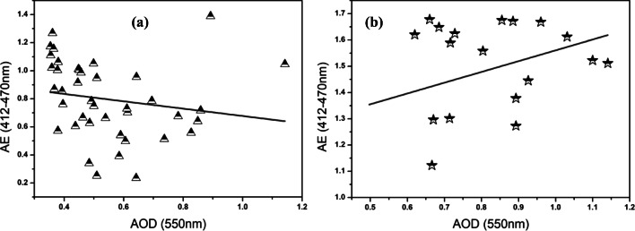
Figure 6 represents the seasonal annual correlation between AOD and AE, pre monsoon (Fig. 6a) and post monsoon (Fig. 6b). AE is the size indicator: small for coarse-mode aerosol particles and large for fine-mode aerosol particles. From Fig. 6, it is clear that AOD correlated with AE in both seasons and in summer due to high dust loading, in which AOD increases but AE decreases because of the larger size of dust particles (course), while in post monsoon/winter, it was due to burning of biomass and bursting of crackers in Diwali festival which increase fine-mode aerosol particles that show a positive correlation. Correlating the data between AOD and AE by Pearson correlation analysis revealed a significant positive correlation (r = 0.65, P < 0.001). High AE value is observed in October to November because of stubble burning during the harvest season in Northern India. Also, bursting of crackers during the festival of Deepawali increases the fine-mode aerosol loading in the atmosphere.
Fig. 6.
Correlation between AOD550 nm and AE412–470 nm over Lucknow for the period 2010 to 2019
Health effects
Air pollution now represents a considerable global pandemic and is one of the largest environmental health threats humanity faces. Though ambient air pollution affects developed and developing countries alike, low- and middle-income countries like India bear the maximum brunt. This silent killer is responsible for about 8 million premature deaths every year, mainly due to increasing incidents of cardiac arrests, compromised lung function, chronic obstructive pulmonary disease, asthma attacks and acute respiratory infections. The crux is that this devil called air pollution has created a total global panic and India as a developing country remains highly vulnerable.
PM is the most critical pollutant among all others from the health perspective. According to Global Burden of Disease Study 2015, exposure to fine particulate (PM2.5) is the 5th leading cause of death globally, causing 4.2 million deaths and 103.1 million disability-adjusted life-years in 2015. Reinmuth-Selzle et al. (2017) also observed that PM was responsible for various types of allergies. Fourteen percent of all new cases of diabetes reported in 2016 were linked to air pollution, especially PM2.5, which enters the bloodstream through lungs and reduces insulin production and triggers inflammation. Small-sized particles ranging from 0.001 to 0.1 μm act as the carrier of pathogenic bacteria and viruses which may cause various types of lung infections including pneumonia. Moreover, these particles increase the rate of blood flow, damage the endothelial cell walls and may even cause cancer. They are also associated with elevated clotting activity, constriction of the airways and fever initiation. Ultrafine particles may cause imbalance between oxygen and carbon dioxide in the lungs. They also inhibit the function of alveolar ducts which basically assist the alveoli to collect the air that has been inhaled, and help in dispersing it to the alveolar sac.
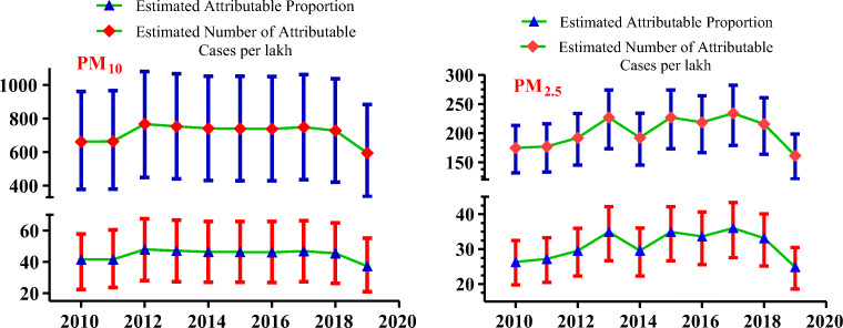
It has been observed (Fig. 7) that the annual mean values of PM10 are more than three times the prescribed standard on PM10, i.e. 60 μg/m3 except 2019. Health impact of PM10 on post-neonatal mortality has been determined, and it has been observed that out of the total post-neonatal deaths, more than 1/4 is due to exposure of PM10. This study also investigates the impact of PM2.5 which is more than twice of prescribed standards. It has been observed that the higher value of PM2.5 is responsible for 32% of deaths over the study period (2010–2019). On average, the attributable death rate per lakh population has been observed to be 202 which is much higher than the nation’s and state’s attributable death rates, i.e. 89.9 and 111.1, respectively (Weiss et al. 2019).
Fig. 7.
Health impacts attributable to long-term exposure to PM10 (post-neonatal infant mortality) and PM2.5 (mortality from all causes). The confidence intervals (lower and upper) for the number of excess cases are indicated using bars
SO2 is a highly reactive gas and is soluble in water so when inhaled via nose or mouth during breathing, it is mostly absorbed by mucosa and causes various types of allergies. It also causes coughing, wheezing, asthma and a tight feeling around the chest. Concentrations greater than 100 μg/m3 cause inflammation and irritation on the skin. Sometimes, the gas also reacts with other carcinogenic chemicals present in the atmosphere and changes into smaller-sized particles capable of penetrating deep into the lungs and inhibiting the process of gaseous exchange (Pool et al. 1988).
NO2 exposure may lead to increased asthma attacks and aggravated respiratory illnesses. Lesions in tissues connecting airways with the region of gaseous exchange may be formed with continuous exposure. There is inadequate evidence regarding NO2 as a potential carcinogen. However, it is considered that NO2 could produce nitrates and nitrites by reacting with amines forming nitrosamines which are carcinogenic agents (Song et al. 2015).
Pb poisoning is called as plumbism, colica pictorial or painter’s colic. It is one such pollutant which, when enters the human body, is hard to flush out. Pb interferes with many body processes and affects almost all organ systems. It damages the central nervous system and is therefore particularly toxic to children who absorb the pollutant at a faster rate than adults. It binds with the sulphydryl group present on many enzymes and mimics other metals which act as cofactors in enzymatic reactions. It also interferes in heme synthesis leading to anaemia. In the brain, it is able to pass the blood-brain barrier by substituting the calcium ions causing a neuromuscular disease called as Pb palsy. Pb tends to accumulate in the environment and enters the food chain.
Ni is particularly toxic to human beings and is a known carcinogen. Incidences of lung, kidney and prostate cancers have been reported in workers exposed to high concentrations of Ni. Ni in combination with carbon group forms a highly poisonous gas (Ni(CO)4). Sensitive people may develop allergy to nickel which affects their skin (US EPA 1999). This condition is known as contact dermatitis. Ni may also impair the development of embryo, leading to congenital defects.
Aerosols have an enormous effect on the Earth’s climate system and air quality, which significantly affects human health. Various epidemiological studies associate aerosols with dire health effects like increased mortality, respiratory illness and cardiovascular diseases. Ultrafine particle (dp < 100 nm) are particularly hazardous to humans as these are small enough to pass through the membranes of the respiratory tract and enter the bloodstream. They can also be transported along olfactory nerves into the brain. Bio-aerosols are segment of atmospheric particulate matter that are released from terrestrial and marine ecosystems into the atmospheres. These include a wide variety of living and dead components like bacteria, viruses, fungi, dispersal units like pollen grains and fungal spores and also cellular material from animals and plants. Fröhlich-Nowoisky et al. (2016) also suggested that aerosols work as a carrier of various living and dead components. There is still a dearth of evidence to establish a clear correlation between the physical and chemical properties of ultrafine and large aerosols that actually have adverse health effects on human beings. Bio-aerosols may be allergenic and infectious to living organisms, which influence human health and agriculture on regional and global levels (Reinmuth-Selzle et al. 2017). The health effect of aerosols can be broadly classified into two categories, namely short-term and acute effects like asthmatic attacks and bronchitis and long-term chronic effects like infectious diseases, respiratory allergies and cancer.
Conclusions
The present research concluded that the level of atmospheric particulate matter in all considered locations remained much above the standard prescribed limits, all throughout the stated period. The maximum average concentration of PM10 and PM2.5 were 226.55 and 115.0 μg/m3, 270.75 and 111.55 μg/m3 and 225.60 and 124.95 μg/m3 for residential, commercial and industrial areas, respectively. Charbagh and Chowk had the highest particulate pollution possibly due to excessive vehicular movement, increased construction activities, open garbage burning, commercial and industrial activities, etc. Saving SO2, the observed values of all the other pollutants were higher than the NAAQS standards and this is what has fast transformed the city into an air pollution epicenter, grappling with diseases like ischaemic heart disease, stroke, lung cancer, COPD and acute respiratory infections. On an average, the attributable death rate per lakh population has been observed as 202 in the case of PM2.5 for all causes and 714 in the case of PM10 for post-neonatal death which is much higher than the nation’s and state’s attributable death rates. Amid the consequences of the coronavirus lockdown, the ambient air quality of the city improved considerably, bringing the AQI score into the safe and healthy category. The maximum impact was seen in the PM values of the areas in which high PM levels were reported earlier, historically. Since this is a temporary relief, the need of the hour is to implement long-term measures like strengthening the public transport system, discouraging the use of private vehicles by imposing healthy congestion charges, checking dieselization, offering scrappage schemes for most polluting vehicles, providing for compulsory tarpaulin or protective canvas around construction sites and blanket ban on burning of waste to keep the health hazards at bay.
Acknowledgements
The first author is highly grateful to the Director, CSIR-IITR, Lucknow, for providing the necessary facilities for this research. Furthermore, we would like to thankfully acknowledge the MODIS Terra and Aqua part of NASA team for providing the satellite data on online visualization and analysis infrastructure (Giovanni).
Authors’ contributions
The main investigator was Markandeya, who designed the manuscript. The technical drafting of the manuscript was done by NKS, while VM and PKV helped in the writing and data collection, respectively. Moreover, SPS and DM were advisors of the present research. All the authors have read and approved the manuscript.
Data availability
The datasets used and/or analyzed during the current study are available from the corresponding author on reasonable request.
Compliance with ethical standards
Competing interests
The authors declare that they have no competing interests.
Ethical approval and consent to participate
Not applicable
Consent for publication
Not applicable
Footnotes
Highlights
• Spatio-temporal assessment of various pollutants like PM10, PM2.5, SO2, NO2, Pb, Ni and atmospheric aerosols from 2010 to 2019 was performed.
• AQI score for most of the studied locations was found in the poor category.
• During the lockdown, AQI scores decreased to well below 50, in the healthy range.
• High AE value was observed in October to November because of stubble burning during the harvest season in Northern India.
• The health impact of air pollutants was estimated using AirQ+ software.
• Long-term exposure to PM2.5 to ambient air increased the risk of stroke by 20%.
Publisher’s note
Springer Nature remains neutral with regard to jurisdictional claims in published maps and institutional affiliations.
Contributor Information
Markandeya, Email: mktiwariiet@gmail.com.
Devendra Mohan, Email: devmohan9@gmail.com.
References
- Air Quality Index by Central Pollution Control Board (2020) http://www.cpcb.gov.in/CAAQM/frmCurrentDataNew.aspx?StationName=Ihbas&StateId=6&CityId=85 Accessed 25-5 April-May 2020
- Assessment of ambient air quality of Lucknow City (2010–2019) CSIR Indian Institute of Toxicology Research (CSIR-IITR), Lucknow. http://iitrindia.org/En/environmental_status_reports.aspx. Accessed 25-5 April-May 2020
- Atkinson RW, Butland BK, Anderson HR, Maynard RL. Long-term concentrations of nitrogen dioxide and mortality: a meta-analysis of cohort studies. Epidemiology. 2018;29(4):460–472. doi: 10.1097/EDE.0000000000000847. [DOI] [PMC free article] [PubMed] [Google Scholar]
- Barman SC, Singh R, Negi MPS, Bhargava SK. Ambient air quality of Lucknow City (India) during use of fireworks on Diwali festival. Environ Monit Assess. 2008;137:495–504. doi: 10.1007/s10661-007-9784-1. [DOI] [PubMed] [Google Scholar]
- Beig G, Chate DM, Ghude SD, Mahajan AS, Srinivas R, Ali K, Sahu SK, Parkhi N, Surendran D, Trimbake HR. Quantifying the effect of air quality control measures during the 2010 Commonwealth Games at Delhi, India. Atmos Environ. 2013;80:455–463. doi: 10.1016/j.atmosenv.2013.08.012. [DOI] [Google Scholar]
- Central Pollution Control Board (CPCB) annual report, 2006–2007. http://164.100.107.13/upload/AnnualReports/AnnualReport_34_Annual-Report-06-07.pdf
- Das SK, Jayaraman A. Role of black carbon in aerosol properties and radiative forcing over Western India during premonsoon period. Atmos Res. 2011;102(3):320–334. doi: 10.1016/j.atmosres.2011.08.003. [DOI] [Google Scholar]
- Das S, Dey S, Dash SK, Giuliani G, Solmon F. Dust aerosol feedback on the Indian summer monsoon: sensitivity to absorption property. J Geophys Res-Atmos. 2015;120(18):9642–9652. doi: 10.1002/2015JD023589. [DOI] [Google Scholar]
- Fröhlich-Nowoisky J, Christopher JK, Weber B, Huffman JA, Pöhlker C, Andreae MO, Lang-Yona N, Burrows SM, Gunthe SS, Elbert W, Su H, Hoor P, Thines E, Hoffmann T, Després VR, Pöschl U. Bioaerosols in the earth system: climate, health, and ecosystem interactions. Atmos Res. 2016;182:346–376. doi: 10.1016/j.atmosres.2016.07.018. [DOI] [Google Scholar]
- Ghorani-Azam A, Riahi-Zanjani B, Balali-Mood M (2016) Effects of air pollution on human health and practical measures for prevention in Iran. J Res Med Sci 21:–65. 10.4103/1735-1995.189646 [DOI] [PMC free article] [PubMed]
- Ghosh R, Chakraborty A, Nanjundiah RS. Relative role of pre-monsoon conditions and intra-seasonal oscillations in determining early-vs-late Indian monsoon intensity in a GCM. Theor Appl Climatol. 2018;131:319–333. doi: 10.1007/s00704-016-1970-z. [DOI] [Google Scholar]
- Gupta P, Khan MN, da Silva A, Patadia F. MODIS aerosol optical depth observations over urban areas in Pakistan: quantity and quality of the data for air quality monitoring. Atmos Pollut Res. 2013;4:43–52. doi: 10.5094/APR.2013.005. [DOI] [Google Scholar]
- Gurjar BR, Ravindra K, Nagpure AS. Air pollution trends over Indian megacities and their local-to-global implications. Atmos Environ. 2016;142:475–449. doi: 10.1016/j.atmosenv.2016.06.030. [DOI] [Google Scholar]
- Hai DN, Tung LV, Van DK, Binh TT, Phuong HL, Trung ND, Son ND, Giang HT, Hung NM, Khue PM (2018) Lead environmental pollution and childhood lead poisoning at Ban Thi Commune, Bac Kan Province, Vietnam. Biomed Res Int:5156812. 10.1155/2018/5156812 [DOI] [PMC free article] [PubMed]
- Havens D, Pham MH, Karr CJ, Daniell WE (2018) Blood lead levels and risk factors for lead exposure in a pediatric population in Ho Chi Minh City, Vietnam. Int J Environ Res Public Health 15(1). 10.3390/ijerph15010093 [DOI] [PMC free article] [PubMed]
- Kumar M, Parmar KS, Kumar DB, Mhawish A, Broday DM, Mall RK, Banerjee T. Long-term aerosol climatology over Indo-Gangetic Plain: trend, prediction and potential source fields. Atmos Environ. 2018;180:37–50. doi: 10.1016/j.atmosenv.2018.02.027. [DOI] [Google Scholar]
- Kumar S, Srivastava AK, Pathak V, Bisht DS, Tiwari S. Surface solar radiation and its association with aerosol characteristics at an urban station in the Indo-Gangetic Basin: implication to radiative effect. J Atmos Sol Terr Phys. 2019;193:105061. doi: 10.1016/j.jastp.2019.105061. [DOI] [Google Scholar]
- Markandeya, Shukla SP, Kisku GC. Linear and non-linear kinetic modeling for the adsorption of disperse dye in a batch process. Res J Environ Toxicol. 2015;9(6):320–331. doi: 10.3923/rjet.2015.320.331. [DOI] [Google Scholar]
- Markandeya, Pratap D, Kumar V, Shukla NK. Seasonal variation of ozone in industrial area of Singrauli, India. Middle-East J Sci Res. 2016;24(1):11–14. doi: 10.5829/idosi.mejsr.2016.24.01.22566. [DOI] [Google Scholar]
- Markandeya, Shukla SP, Kisku GC. A clean technology for future prospective: emission modeling of gas based power plant. Open J Air Pollut. 2016;5:144–159. doi: 10.4236/ojap.2016.54011. [DOI] [Google Scholar]
- Markandeya, Kisku GC, Shukla SP. Role of aerosols in climate change and cloud formation emission released from coal based power plant. SF J Glob Warm. 2017;1(1):1–7. [Google Scholar]
- National ambient air quality standards by Central Pollution Control Board. Notification New Delhi. 2009. https://scclmines.com/env/DOCS/NAAQS-2009.pdf. Accessed 25-5 April-May 2020
- Pandey P, Khan AH, Verma AK, Singh KA, Mathur N, Kisku GC, Barman SC. Seasonal trends of PM2.5 and PM10 in ambient air and their correlation in ambient air of Lucknow City, India. B Environ Contam Tox. 2011;88(2):265–270. doi: 10.1007/s00128-011-0466-x. [DOI] [PubMed] [Google Scholar]
- Pandey P, Patel DK, Khan AH, Barman SC, Murthy RC, Kisku GC. Temporal distribution of fine particulates (PM2.5, PM10), potentially toxic metals, PAHs and metal-bound carcinogenic risk in the population of Lucknow City, India. Journal of Environmental Science and Health, Part A: Toxic/Hazardous Substances and Environmental Engineering. 2013;48(7):730–745. doi: 10.1080/10934529.2013.744613. [DOI] [PubMed] [Google Scholar]
- Pathak H, Bhatia A (2018) Reactive nitrogen and its impacts on climate change: an Indian synthesis. The Indian Nitrogen Assessment Elsevier 383–401. 10.1016/B978-0-12-811836-8.00024-0
- Pool BL, Janowsky I, Klein P, Klein RG, Schmezer P, Vogt-Leucht G, Zeller WJ. Effects of SO2 or NOx on toxic and genotoxic properties of chemical carcinogens. I. In vitro studies. Carcinogenesis. 1988;9(7):1237–1245. doi: 10.1093/carcin/9.7.1237. [DOI] [PubMed] [Google Scholar]
- Reinmuth-Selzle K, Kampf CJ, Lucas K, Lang-Yona N, Fröhlich-Nowoisky J, Shiraiwa M, Lakey PSJ, Lai S, Liu F, Kunert AT, Ziegler K, Shen F, Sgarbanti R, Weber B, Bellinghausen I, Saloga J, Weller MG, Duschl A, Schuppan D, Pöschl U. Air pollution and climate change effects on allergies in the anthropocene: abundance, interaction, and modification of allergens and adjuvants. Environ Sci Technol. 2017;51(8):4119–4141. doi: 10.1021/acs.est.6b04908. [DOI] [PMC free article] [PubMed] [Google Scholar]
- Satterthwaite D, McGranahan G, Tacoli C. Urbanization and its implications for food and farming. Philos Trans R Soc Lond Ser B Biol Sci. 2010;365(1554):2809–2820. doi: 10.1098/rstb.2010.0136. [DOI] [PMC free article] [PubMed] [Google Scholar]
- Seinfeld JH, Pandis SN. From air pollution to climate change. Atmospheric chemistry and physics. 3. 1998. p. 1152. [Google Scholar]
- Shen X, Bilal M, Qiu Z, Sun D, Wang S, Zhu W. Long-term spatiotemporal variations of aerosol optical depth over Yellow and Bohai Sea. Environ Sci Pollut Res. 2019;26:7969–7979. doi: 10.1007/s11356-019-04203-4. [DOI] [PubMed] [Google Scholar]
- Shukla JB, Misra AK, Sundar S, Naresh R. Effect of rain on removal of a gaseous pollutant and two different particulate matters from the atmosphere of a city. Math Comput Model. 2008;48(5–6):832–844. doi: 10.1016/j.mcm.2007.10.016. [DOI] [Google Scholar]
- Song P, Wu L, Guan W. Dietary nitrates, nitrites, and nitrosamines intake and the risk of gastric cancer: a meta-analysis. Nutrients. 2015;7(12):9872–9895. doi: 10.3390/nu7125505. [DOI] [PMC free article] [PubMed] [Google Scholar]
- Srivastava AK, Singh S, Tiwari S, Bisht DS. Contribution of anthropogenic aerosols in direct radiative forcing and atmospheric heating rate over Delhi in the Indo-Gangatic Basin. Environ Sci Pollut Res. 2012;19:1144–1158. doi: 10.1007/s11356-011-0633-y. [DOI] [PubMed] [Google Scholar]
- Tiwari M, Shukla SP, Shukla NK, Singh RB, Mumtaz N, Gupta VK, Singh V. Emission profile of pollutants due to traffic in Lucknow City, India. Int Res J Public Environ Health. 2014;1(7):150–157. doi: 10.15739/irjpeh.001. [DOI] [Google Scholar]
- Tiwari S, Srivastava AK, Singh AK, Singh S. Identification of aerosol types over Indo-Gangetic Basin: implications to optical properties and associated radiative forcing. Environ Sci Pollut Res. 2015;22:12246–12260. doi: 10.1007/s11356-015-4495-6. [DOI] [PubMed] [Google Scholar]
- Tiwari S, Singh RK, Srivastava AK, Soni VK, Tiwari S, Singh RS, Srivastava MK, Singh AK. Identification of aerosol sources and its characterization at Varanasi: an air mass based study. Int J Earth Atmos Sci. 2018;5(1):19–35. [Google Scholar]
- U.S. Environmental Protection Agency . Integrated Risk Information System (IRIS) on nickel carbonyl. Washington, DC: National Center for Environmental Assessment. Office of Research and Development; 1999. [Google Scholar]
- Weiss DJ, Lucas TCD, Nguyen M, Nandi AK, Bisanzio D, Battle KE, Cameron E, Twohig KA, Pfeffer DA, Rozier JA, Gibson HS, Rao PC, Casey D, Bertozzi-Villa Amelia, Collins EL, Dalrymple U, Gray N, Harris JR, Howes RE, Kang SY, Keddie SH, May D, Rumisha S, Thorn MP, Barber R, Fullman N, Huynh CK, Kulikoff X, Kutz, MJ, Lopez AD, Mokdad AH, Naghavi M, Nguyen G, Shackelford K, Vos AT, Wang H, Smith DL, Lim SS, Murray CJL, Bhatt S, Hay SI, Gething PW (2019) Mapping the global prevalence, incidence, and mortality of Plasmodium falciparum, 2000–17: a spatial and temporal modelling study, The Lancet 394(10195):322–331. 10.1016/S0140-6736(19)31097-9
- WHO (2006) Use of air quality guidelines in protecting public health: global update. Available at http://www.who.int/mediacentre/factsheets/fs313/enS. Accessed 25-5 April-May 2020
- WHO, Global Urban Ambient Air Pollution Database (2016) Ambient air pollution: a global assessment of exposure and burden of disease. In: World Health Organization https://www.who.int/phe/publications/air-pollution-global-assessment/en/. Accessed 25-5 April-May 2020
- Winkler SL, Anderson JE, Garza L, Ruona WC, Vogt R, Wallington TJ (2018) Vehicle criteria pollutant (PM, NOx, CO, HCs) emissions: how low should we go? NPJ Clim Atmos Sci 1:26. 10.1038/s41612-018-0037-5
- World air quality report–IQAir (2019) https://www.iqair.com/world-most-polluted-cities/world-air-quality-report-2019-en.pdf. Accessed 25-5 April-May 2020
- Wu SP, Cai MJ, Xu C, Zhang N, Zhou JB, Yan JP, Schwab JJ, Yuan CS. Chemical nature of PM2.5 and PM10 in the coastal urban Xiamen, China: insights into the impacts of shipping emissions and health risk. Atmos Environ. 2020;227:117383. doi: 10.1016/j.atmosenv.2020.117383. [DOI] [Google Scholar]
- You Y, Zhao T, Xie Y, Zheng Y, Zhu J, Xia J, Cao L, Wang C, Che H, Liao Y, Duan J, Zhou J, Zhou X (2020) Variation of the aerosol optical properties and validation of MODIS AOD products over the eastern edge of the Tibetan Plateau based on ground-based remote sensing in 2017. Atmos Environ. 10.1016/j.atmosenv.2019.117257
- Zhang K, Batterman S. Air pollution and health risks due to vehicle traffic. Sci Total Environ. 2013;450–451:307–316. doi: 10.1016/j.scitotenv.2013.01.074. [DOI] [PMC free article] [PubMed] [Google Scholar]
Associated Data
This section collects any data citations, data availability statements, or supplementary materials included in this article.
Data Availability Statement
The datasets used and/or analyzed during the current study are available from the corresponding author on reasonable request.


