

Abstract
Indigenous people play an integral role in shaping natural environments, and the disruption to Indigenous land management practices has profound effects on the biosphere. Here, we use pollen, charcoal and dendrochronological analyses to demonstrate that the Australian landscape at the time of British invasion in the 18th century was a heavily constructed one—the product of millennia of active maintenance by Aboriginal Australians. Focusing on the Surrey Hills, Tasmania, our results reveal how the removal of Indigenous burning regimes following British invasion instigated a process of ecological succession and the encroachment of cool temperate rainforest (i.e. later-stage vegetation communities) into grasslands of conservation significance. This research provides empirical evidence to challenge the long-standing portrayal of Indigenous Australians as low-impact ‘hunter-gatherers’ and highlights the relevance and critical value of Indigenous fire management in this era of heightened bushfire risk and biodiversity loss.
Keywords: Cultural heritage, Dendrochronology, Fire, Indigenous Australia, Palaeoenvironments, Western Tasmania
Introduction
European and British invasions of the New World and the Antipodes between the 15th and 19th centuries wrought devastation on Indigenous cultures, communities, and their land management practices (Paterson 2013; Koch et al. 2019). Massive landscape changes resulted, with effects that reverberated around the globe (Dull et al. 2010; Liebmann et al. 2016; Loughlin et al. 2019) and which continue to impact the environment today (Romanin et al. 2016; Archer et al. 2017; Moura et al. 2019). One such problem is the post-invasion rapid loss of anthropogenic ecosystems, such as grasslands that were maintained for millennia by people and which are now endangered in many places on Earth (Norman and Taylor 2005; Coop and Givnish 2007; Butler et al. 2014; Sühs et al. 2020). The contraction of grassland ecosystems globally represents a critical loss of floral and faunal biodiversity (Partel et al. 2005; Murphy et al. 2016), habitat diversity and connectivity (Coppedge et al. 2002), foraging grounds for native herbivores and livestock, and cultural landscapes significant to indigenous communities (Blackstock and McAllister 2004; Gammage 2008; Onfray 2012). Additionally, the loss of grasslands can alter hydrological cycles (Nadal-Romero et al. 2013), carbon cycling, soil nutrient budgets (Jackson et al. 2002; McKinley and Blair 2008) and fire regimes through increased fuel loading and the closing of fire breaks (Bond and Parr 2010).
In Australia, many landscapes that were described as open and grassy under indigenous management are now forested, yet debate rages over the full role of Aboriginal people in the creation and maintenance of their landscape, with views ranging from benign opportunism to wilful mastery (Horton 1982; Bowman 1998; Langton 1998; Gammage 2011; Pascoe 2014). This problem is difficult to assess, given that the timing of the initial arrival of people to Australia is uncertain, owing to technical advancements and site discoveries continually pushing back human arrival dates (Clarkson et al. 2017). More than just academic, this dispute has real implications for informing appropriate and sustainable landscape management regimes.
While uncertainty surrounding the initial impact signal of human arrival in Australia persists, there is potential instead to investigate the impact of the rapid and severe decimation of Aboriginal communities and the loss of their management regimes at the hands of the British invaders in the 18th and 19th centuries. Australia faces several significant environmental challenges that stem from both global climatic change and the legacy of substituting Indigenous with colonial landscape management following British invasion after 1788. In contrast to the veritable Eden described by the first British invaders to Australia (Gammage 2011), the continent has proved to be incompatible with European management paradigms (Kirkpatrick 1999; Bradshaw 2012; Glanznig and Kennedy 2019). Increasing rates of soil salinization from over-irrigation (Lambers 2003), soil erosion from landscape denudation (Bui et al. 2010), catastrophic wildfire facilitated by unhindered fuel accumulation (Enright and Thomas 2008) and rapid rates of species loss (Woinarski et al. 2015) all point to a catastrophic management failure of the Australian landscape since the British invasion.
Early written depictions of Australian landscapes are full of superlatives, depicting a bountiful landscape reminiscent of England and well suited to European agriculture—a landscape in which we find an apparent paradoxical flourishing of sedentary Aboriginal communities in the heart of what is now considered Australia’s harshest deserts (Pascoe 2014). Indeed, the first impressions of the botanical draughtsman onboard Captain James Cook’s “First Fleet” in 1788 were the following:
The country looked very pleasant and fertile, and the trees, quite free from underwood, appeared like plantations in a gentleman’s park (cited in Gammage 2011).
Depictions like the one above are numerous in the ethnographic record of Australia and are echoed in landscape art from the early post-invasion period (the ethno-pictorial record) (Gammage 2011). Moreover, clear written accounts of permanent Aboriginal settlements, large-scale Aboriginal agriculture and aquaculture, and sophisticated Aboriginal religious practices abound in the writings of British settlers, all pointing to highly successful Aboriginal management of the Australian continent stolen by the British (Pascoe 2014). Despite the clear evidence of Aboriginal environmental manipulation, resource exploitation and sedentism, the unconscious and often wilful amnesia of mainstream Australian culture has forever cast Australian Aboriginal people in the mould of the noble savage (Rowland 2004)—the most base of humans that represented a “missing link” between apes and the most advanced humans, 19th Century Europeans (Waitt 1999), people that were incapable of landscape modification, let alone the concept of land ownership. The emerging counter-narrative of Australian Aboriginal societies, cast into the public arena by efforts of people like Bill Gammage and Bruce Pascoe (Gammage 2011; Pascoe 2014), challenges the central tenet underpinning the concept of terra nullius (vacant land) on which the tenuous and uneasy claims of sovereignty of white Australia over Aboriginal lands rests (Fitzmaurice 2007). Moreover, this counter-narrative reveals the Australian landscape to be a construct of human agency and provides critical insights into the factors underlying Australia’s modern environmental dilemmas.
While the written and painted record of Australia’s early colonial history has presented a recent challenge and rebuke of the noble savage/hunter-gatherer moniker, the scientific community has been comparatively silent on this topic. With some exceptions, the analysis of the archaeological and palaeo-environmental records of Australia have generally failed to shed significant light on the role of Aboriginal people in the origin and maintenance of the Australian landscape (Builth et al. 2008; Fletcher and Thomas 2010; Butler et al. 2014). The poor preservation of non-lithic (stone) remains in archaeological deposits in Australia’s harsh environment and an overwhelming bias toward the archaeology of cave-dwelling economies over much of the continent, particularly in the southeast (e.g. Bird and Frankel 1991; Cosgrove 1999), has limited the ability of archaeology to contribute to this discourse meaningfully. Likewise, the paucity of continuous palaeo-environmental records that span the assumed period of arrival of people to this continent, coupled with the increasing uncertainty over when people actually arrived in Australia and the large uncertainties in dating cultural material beyond the limits of conventional methods (such as radiocarbon > 40 000 years old) (e.g. Kershaw et al. 2007a, b; Mooney et al. 2011), precludes an understanding of how Aboriginal people modified the Australian landscape and how that modification is manifested under the very different climatic regime that has prevailed over the most recent millennia (Fletcher and Thomas 2010). To better understand Aboriginal land use and landscape modification, therefore, we focus instead on analysing the recent past—specifically, the vegetation response of the 18th and 19th century reduction of Aboriginal land uses. We argue that the extent to which Australian ecosystems had been constrained and/or constructed by Indigenous Australians at the time of British invasion will be reflected in the nature and degree to which the vegetation landscape has ‘rebounded’ following the cessation of Indigenous land management practices.
Here, we document the rapid expansion of forest into grasslands that represents the loss of an Aboriginal constructed landscape following the British invasion and conquest of Tasmania, demonstrating a deep human imprint on an Australian landscape and underscoring the clearly relevant role of Aboriginal land management in the contemporary Australian landscape. This knowledge is critical for understanding the context of several of Australia’s most pressing environmental concerns, most notably the recent and ongoing bushfire emergency and the role in which long-term fuel accumulation in the absence of Aboriginal fire management plays in this very serious problem (Wilman 2015). Fire was an important landscape management tool employed by Aboriginal people in Australia. Among a range of cultural uses, fire is used by Aboriginal people to protect and enhance resources essential to survival. One such method is to suppress woody species that are intolerant of frequent burning in favour of faster-growing and fire-tolerant grass species, which provide seed for harvest and food for fauna (Jones 1969; Pascoe 2014), as well as reducing landscape fuel loads that mitigates against large uncontrolled wildfire in flammable biomes (Murphy et al. 2009).
In this paper, we use the Surrey Hills in temperate northwest Tasmania, Australia, as a case study. The Surrey Hills was described and mapped in detail by Henry Hellyer in 1828 (Fig. 1) as a mix of grassland and Eucalypt-savanna (Eucalyptus sp. trees over a grassy understorey), with abundant evidence for recent Aboriginal burning and with pyrophobic rainforest representing a minor component of the vegetation restricted to the banks of rivers (Thomas 2011). Today, areas not overtaken by silviculture are predominantly rainforest, with a few isolated patches of grassland managed for conservation with fire. We employ indicators of past vegetation change (pollen) and fire activity (charcoal) stored in organic-rich soils and an indicator of tree establishment date (tree-rings) to track the response of forest to the shift from Aboriginal to British tenure and management. We hypothesise that if the grasslands observed in the early post-British invasion phase in the Surrey Hills (circa 1828) were an Aboriginal construct produced by systematic and sophisticated landscape burning by local Aboriginal communities, that the shift to British management in which fire was not a key component would have resulted in a replacement of grassland and Eucalypt-savanna by pyrophobic rainforest (sensu Bowman et al. 2013). In this case, pollen and charcoal records will depict a shift from fire-maintained grassland or Eucalypt-savanna to fire-free rainforest vegetation. Further, we hypothesise that the establishment date of the vast majority of rainforest trees in this landscape will post-date the first arrival of British settlers to the region (the early 1830s). We specifically ask the following questions:
What vegetation type occupied modern rainforest patches prior to the British invasion?;
What is the establishment age pattern of trees within modern rainforest?;
Does the historical vegetation and tree demography data support the notion that the Surrey Hills was an Aboriginal constructed landscape?
Fig. 1.

a Global view showing location of Tasmania, Australia. b Map of Tasmania showing the location of The Surrey Hills region. c Hellyer’s (1828) map of The Surrey Hills, showing extent and location of grassland plains (Thomas, 2011). d Extent of basalt lava flow that has produced the fertile soils of The Surrey Hills region. Location of field sites used in this study [Dairymaid Plain (DMP) and Racecourse Plain (RCP)] are also indicated (Background satellite imagery source: Esri, DigitalGlobe, GeoEye, Earthstar Geographics, CNES/Airbus DS, USDA, USGS, AeroGRID, IGN, and the GIS User Community. Basalt geology unit source: obtained from the 1:250 000 Scale Digital Geology of Tasmania dataset provided by the Mineral Resources Tasmania; displayed under the CC Attribution 3.0 Australia licence)
Materials and methods
Study site
Northwest Tasmania is host to some of the most extensive later-stage rainforest communities remaining in southeast Australia today. The Surrey Hills (Fig. 1) is a gently undulating terrain formed on an extensive ancient lava flow (Basalt Unit in Fig. 1d), which produces comparatively fertile soils when compared to the broader region. On these soils, rainforest is the expected vegetation type in the absence of fire (Jackson 1968).
Upon observing the Surrey Hills in 1828, Henry Hellyer, the principle surveyor for the newly formed Van Diemen’s Land Company (VDL) who was in search of lands to run sheep, remarked as follows:
an excellent country, consisting of gently rising, dry, grassy hills, divided from each other by brooks, the sides of which are adorned with blackwood and other elegant trees and shrubs…The plains, or rather hills, I call the Surrey Hills…They resemble English enclosures in many respects, being bounded by brooks between each, with belts of beautiful shrubs in every vale…The whole country here is grassy…The timber found on these hills is, in general, of fine growth, very tall and straight; some of it would measure more than 100 feet to the lowest branch. The trees are in many places 100 yards apart… They are principally peppermint and stringy bark, —. It will not in general average ten trees on an acre. There are many plains of several square miles without a single tree. (cited in Thomas 2011).
And further of the Surrey Hills:
The chase has a cultivated and diversified appearance… from its having been lately burnt in several extensive tracts, looking fresh and green in those places, and in others so completely covered with fields of blooming heath that it resembled vast fields of clover divided by shrubs… It is possible that the natives by burning only one set of plains are enabled to keep the kangaroos more concentrated for their use, and I can in no way account for their burning only in this place, unless it is to serve them as a hunting place (cited in Thomas 2011).
The landscape Hellyer consistently describes is a mix of temperate grasslands, temperate Eucalypt-savanna, with rainforest and shrub communities confined to the banks of creeks and rivers (Gammage 2008; Onfray 2012), a landscape that was deliberately managed and maintained by Aboriginal people with fire, while the familiarity of the kangaroo to humans and the clear and abundant evidence of Aboriginal occupation in the area (Thomas 2011) implies that these animals were more akin to livestock than “wild” animals. Hellyer produced a detailed map of the “Surrey Hills” grasslands (Fig. 1c), indicating substantial areas of grassland in 1828 where rainforest now grows (Bowman et al. 2013). The region mapped by Hellyer corresponds almost precisely (given the accuracy of the day) to a large basaltic lava flow that extends to the north of the Surrey Hills to the coast (Fig. 1c, d). This coastward extension of the basalt flow corresponds to what Hellyer named the “Hampshire Hills”, an equally impressive grassy/savanna landscape (Thomas 2011; Onfray 2012). Hellyer’s observations prompted the VDL to send sheep to the Surrey Hills in what would eventually be a failed venture (Onfray 2012). The Surrey Hills are relatively high-elevation grasslands seasonally covered in snow and the area proved too cold for a viable operation that suited high-profit ambitions of the VDL (Evans 2010). Nevertheless, the observations of Hellyer set in motion a chain of events that led to the rapid and violent extirpation of Aboriginal people from the Surrey Hills region during the 1830s (Evans 2010).
The period between 1830 and 1960 was marked by the failed VDL venture and subsequent occupation of the Surrey Hills by wild mobs of cattle, stockmen and snarers living in dilapidated huts along with ad hoc burning and hunting, while the period after 1960 ushered in the silvicultural estate that persists until the present day and which saw the total exclusion of landscape burning in the Surrey Hills (Evans 2010; Onfray 2012). Today, the region is leased by Forico Pty Ltd and is run as an active silviculture estate. Part of the leasing agreement from the Tasmanian government requires Forico to manage the remnant patches of grassland in the estate with prescribed burning regimes ranging from > 25 to 3 year fire return intervals in an effort, among other things, to maintain populations of the endangered Ptunarra Brown Butterfly (Oreixenica ptunarra) that depends on these grasslands for reproduction and survival (Bell 1998).
Previous investigation into post-British invasion vegetation dynamics on the Surrey Hills focussed on repeat image analysis of aerial photographs compared to hand-drawn maps from post-British invasion surveyors (Bowman et al. 2013). While this work argued for a loss of grassland area in some parts of the Surrey Hills following the cessation of Aboriginal fire management, potential errors between hand-drawn maps and georeferenced aerial imagery limit the accuracy of the conclusions (Bowman et al. 2013). The Surrey Hills lies within the hyperhumid climate zone of Tasmania, where rainforest dominated by Nothofagus cunninghamii (Myrtle Beech) and Phyllocladus aspleniifolius (Celery-top Pine) is the later-stage vegetation community on any substrate in the absence of fire disturbance. Uniquely for this region, the basalt geology produces a relatively flat, well-drained and fertile substrate on which the succession from non-forest to forest vegetation is more rapid than on the topographically complex landscapes comprising less-fertile geology that dominate other parts of the hyperhumid rainforest zone (Bowman and Jackson 1981; Bowman et al. 1986; Bowman and Wood 2009). The dominant ecological model for the region places primacy on the role of the fire return interval (FRI) in determining what type of vegetation occupies a location, with low FRIs (i.e. frequent fires) favouring grassland and high FRIs (i.e. infrequent fires) allowing the development of rainforest (Gilbert 1959; Jackson 1968; Bowman and Jackson 1981; Wood and Bowman 2012). Thus, maintenance of a grassland or savanna vegetation state in this high-rainfall landscape requires a high fire frequency to prevent colonisation by rainforest.
To test the response of the Surrey Hills vegetation to the shift from Aboriginal to British tenure and management, we focussed on two remnant grasslands (Fig. 1): Dairymaid Plain (3–5 year fire return interval (FRI); 41° 25′40″ S, 145° 42′49″ E) and Racecourse Plain (7–9 FRI; 41° 29′16″ S, 145° 43′10″ E). Both locations feature grassland (Poa labillardierei) dominance surrounded by rainforest vegetation. In the case of Dairymaid Plain, the rainforest is dominated by Nothofagus cunninghamii (Myrtle Beech), while at Racecourse Plain, the rainforest dominant is Phyllocladus aspleniifolius (Celery-top Pine).
Pollen and charcoal analysis
A sediment core was extracted from within organic sediments on the banks of Twyford Creek under a canopy of pure Nothofagus cunninghamii (Myrtle Beech) rainforest at Dairymaid Plain (Fig. 2). The sediment core was subsampled at 1-cm intervals for subsequent analysis of pollen, spores and charcoal. For pollen and spore analysis, 0.5 cc of sediment selected at 3 cm intervals was treated with a series of acid and base treatments following standard protocols to isolate the pollen, spores and microscopic charcoal (Faegri and Iversen 1989). The resulting residue was mounted on a microscope slide and pollen, spores and charcoal were tallied until a total of 200 pollen grains from terrestrial (land) plants was reached (hereon called the terrestrial pollen sum—TP). The pollen counts were converted to percentages using the TP, while percentage values for aquatic plants and spores were calculated from a sum that included these palynomorphs. Macroscopic charcoal (> 125 µm) was isolated from 1.25 cc samples at 1 cm intervals using 10% H2O2 to digest all non-charcoal organic material and sieving (Whitlock and Larsen 2001). All charcoal fragments were then tallied, and concentration values were calculated by dividing the charcoal count by the volume of sediment. Relative age control was established by counting the first occurrence of invasive European plant species, such as Pinus sp. (Pine), Rumex acetosella (Red Sorrel), and Plantago lanceolata (Ribwort). These plants must post-date initial invasion by the British in 1772 and most likely post-date the arrival of livestock to the area in the early 1830s (Onfray 2012).
Fig. 2.

The relationship between tree ages (binned to ten year intervals) and distance along the transect, plotted against schematics showing the location of dated trees leading to the transition from rainforest to grassland. Racecourse Plain (RCP) and Dairymaid Plain (DMP). Vertical grey dashed line indicates the timing of Hellyer’s mapping of the region. Location of sediment core retrieved from the Dairymaid Plain site is also shown
Tree establishment
The establishment ages of trees at both Dairymaid Plain and Racecourse Plain was determined by using an increment borer to extract a tree core from both Nothofagus cunninghamii (Myrtle Beech) (at Dairymaid Plain) and Phyllocladus aspleniifolius (Celery-top Pine) (at Racecourse Plain), both are long-lived (> 500 years) species. Sampled trees (N. cunninhammi, n = 30; P. aspleniifolius, n = 40) were located along a transect at both sites (115 m at Dairymaid Plain; 88.9 m at Racecourse Plain) spanning the core of the forest to the forest-grassland boundary (Fig. 2). The closest tree to the transect line was sampled continuously along the transect from core to forest edge. Cores were taken at 1.2 m height above ground and two cores were obtained from each tree at right angles, to ensure capture of the central ring. The cores were mounted, dried and polished prior to counting, with each tree ring estimated to correlate to an individual calendar year (Simkin and Baker 2008). The ages represent the time at which the trees reached sampling height (1.2 m) and not the exact year of establishment.
Results
Pollen and charcoal
Percentage change in key pollen taxa is presented alongside charcoal (representing fire history) in Fig. 3. Introduced plant species occur for the first time at 13 cm, providing a minimum estimate of the post-British invasion period (BIP) and estimated here to indicate the introduction of livestock into the local region in the early 1830s (Onfray 2012). Fire at the site decreases sharply in magnitude and variability in line with the commencement of the BIP (40.1 ± 31.1 particles cm−3 pre-BIP—24–14 cm; 6.3 ± 5.2 particles cm−3 post-BIP—14–0 cm). The pre-BIP phase of the sequence is dominated by Eucalypt, grass and tea tree pollen, while the BIP is characterised by an initial increase in tea tree, followed by the rainforest shrub Tasmannia lanceolata (Mountain Pepper), and finally by the rainforest tree Nothofagus cunninghamii (Myrtle Beech) (which dominated the pollen flora in the uppermost samples (ca. 70% of the terrestrial sum)).
Fig. 3.
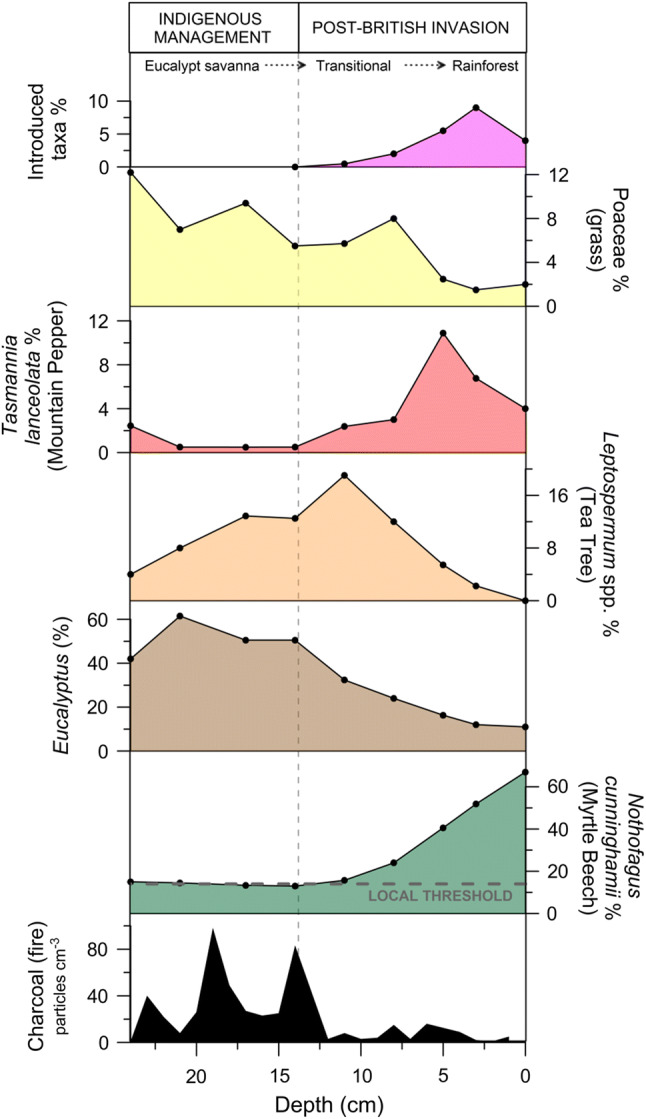
Selected pollen and charcoal results. Vertical grey dashed line indicates timing of British invasion—marked by the introduction of exotic taxa to the region. Horizontal dashed line on myrtle beech represents the threshold above which a local presence of the tree can be inferred (Fletcher and Thomas 2007)
Dendrochronology
Dendrochronological results are presented in Figs. 2 and 4. Figure 4a shows the year of establishment for Nothofagus cunninghamii (Myrtle Beech) and Phyllocladus aspleniifolius (Celery-top Pine) trees surveyed at Dairymaid and Racecourse Plain, respectively. At Dairymaid Plain, two trees are recorded as establishing less than two decades after Hellyer’s 1828 survey of the region, while continual, successful establishment of Nothofagus cunninghamii trees began after 1920. Phyllocladus aspleniifolius began to colonise Racecourse Plain from the late 1800s, with an apparent peak in recruitment occurring just prior to 1900. Collated results (Fig. 4b) reveal that rainforest re-establishment occurred at both sites in the decades immediately following the post-BIP decline in number of Aboriginal people in Tasmania.
Fig. 4.

Dendrochronology results. (top) shows the frequency distribution of tree ages (binned to 10-year intervals) separated by species/site (RCP: Racecource Plain; DMP: Dairymaid Plain). The time Hellyer’s survey conducted is also indicated (1828 CE). (bottom) Shows the collated results in conjunction with an estimated Indigenous population curve [estimated numbers of people are derived from Jones (1971)]
Discussion
The environmental impact of British invasion
Our results highlight the de-stabilising effect that British invasion and the subsequent removal of Indigenous fire regimes had on the Tasmanian vegetation landscape. Rainforest now dominates the non-silvicultural sections of the Surrey Hills, in place of the Eucalypt-savanna depicted in our pollen results and the grassy savanna landscape described and mapped by Hellyer in 1828 (Fig. 1). Before the British invasion, frequent, low-intensity burns by the Indigenous custodians had decoupled the vegetation landscape from climate, discouraging rainforest establishment in favour of a mix of grasslands and Eucalypt-savanna across this high-rainfall and fertile basalt plain (Ellis 1985; Gammage 2008; Onfray 2012). The arrival of British settlers to the Surrey Hills and the systematic and forced removal of Aboriginal people from not only the Surrey Hills, but the entire island, removed traditional fire controls on vegetation, allowing forest to expand.
The period between the 1830s–1960s saw an ad hoc occupation and management of the Surrey Hills by settlers, convicts, trappers, graziers and finally silviculturists, with a range of different uses of fire (Onfray 2012), with total fire exclusion in effect by the 1960s (Needham 1960; Onfray 2012). No tree encountered in our study pre-dates the British invasion (Figs. 2, 4), despite both Nothofagus cunninghamii (Myrtle Beech) and Phyllocladus aspleniifolius (Celery-top Pine) living in excess of 500 years (Ogden 1978), reflecting a clear vegetation response to the change in fire regime. Further, continuous rainforest recruitment has occurred since 1880 (Fig. 4) within the previously open savanna landscape (Fig. 3), suggesting that this recruitment represents forest expansion rather than stand replacement. This combined dendrochronological and palynological evidence signals a major shift in the fire regime of the Surrey Hills that has allowed rainforest to continuously expand at the expense of grassy vegetation.
The removal of systematic Indigenous burning at our core site on the banks of Twyford Creek resulted in a shift from Eucalypt-savanna to a Nothofagus cunninghamii-dominated rainforest, punctuated by increases in Leptospermum (tea tree) sp. and Tasmannia lanceolata (Mountain Pepper) (Fig. 3). This sequence is consistent with the grassland-Leptospermum-rainforest succession pathway described by Ellis (1985) for the Paradise Plains in northeast Tasmania (another cool climate temperate grassland) (Ellis 1985), and with observations of Leptospermum lanigerum (Woolly Tea tree) acting as a rainforest pioneer on the Surrey Hills (Bowman et al. 2013; Wood et al. 2017). Leptospermum lanigerum currently grows along forest margins and facilitates further woody growth (such as Tasmannia lanceolata and Nothofagus cunninghamii) by out-competing (i.e. shading) grasses—instigating a feedback loop that encourages further forest expansion (Wood et al. 2017). This sequence in the pollen record from Twoford Creek likely reflects an increase of Leptospermum lanigerum along the banks of the creek under a savanna canopy in response to the change in fire regime, subsequently facilitating the establishment and expansion of rainforest.
The loss of a constructed landscape
The results of this study reveal two key aspects of the environmental history of the Surrey Hills:
Prior to the British invasion, a Eucalypt-savanna occupied the Dairymaid Plain site under a higher burning regime than present;
Rainforest expansion occurred following the British invasion and the removal of Aboriginal people from the region at both study sites.
These findings are significant, as they unequivocally prove that the shift from Aboriginal to British management of the Surrey Hills saw a rapid shift from a grassy ecosystem to rainforest in complete accordance with the proposed fire-dependent ecological model for this region (Jackson 1968). Our results clearly demonstrate that the Surrey Hills landscape that inspired Hellyer to encourage his employers at the VDL to annex the region for their livestock interests, and in the process forcibly removing the Aboriginal owners and accelerating a process of extirpation that was occurring throughout Australia at the time, was a human-made landscape. This constructed landscape was the product of purposeful and skilful landscape manipulation with fire aimed at decoupling the landscape from its climatic potential (rainforest) to provide a predictable and productive landscape for human occupation: a “farm without fences” (Gammage 2011) (Fig. 5). Indeed, the sophisticated manipulation of high-altitude cold climate grasslands by Aboriginal communities has a very long history in Tasmania, with the incredibly rich cave archaeological deposits of Tasmania’s west recording a targeted economy focussed on the seasonal exploitation of mammals via management of grasslands formed on limestone during the last ice age (Pike-Tay et al. 2008). The Surrey Hills provides potential evidence for the continuation of this ancient seasonal exploitation of cool climate grasslands into the late Holocene, with burning of the Surrey Hills grassland acting to both encourage new grass growth to feed fauna and suppress the establishment of woody vegetation. This vocation clearly requires continual and systematic effort to combat the encroachment of rainforest in this wet climate landscape comprising the fertile (basaltic) soils suited to rapid rainforest growth.
Fig. 5.

Schematic of the changes at Dairymaid Plain inferred from the pollen, charcoal, and dendrochronological data presented in this paper. The blue section represents Twyfold Creek and the location of the core taken for this study. Number of people estimates are derived from Jones (1971)
While only representative of a tiny portion of Australia, this case study from Tasmania provides critical insight into the influence of Aboriginal people on the Australian environment. The park-like savanna landscape depicted in word and paint over and over in the Australian ethnographic and ethnopictorial record stands in stark contrast to the same landscapes we view today (Gammage 2011). The unequivocal case of landscape construction by Aboriginal people we have presented for the Surrey Hills in Tasmania is undoubtedly representative of other parts of Australia. Other examples of the impacts of a cessation of traditional Aboriginal fire management on the Australian landscape include the following: (1) a tenfold increase in woody plant coverage following British invasion of the Bellarine Peninsula in southwest Victoria, mainland southeast Australia (Lunt 1998); (2) a shrub invasion of spinifex grasslands around the great monument of Uluru in the interior of Australia that has had clear knock-on effects for flora and fauna biodiversity (Masters 1993); and (3) a shift to massive and catastrophic late dry season wildfires in the absence of Aboriginal management in the tropical savannas of northern Australia (Russell-Smith et al. 2013).
These examples above, coupled with the clear evidence for Aboriginal landscape construction presented here in Tasmania, stand in stark contrast to the hunter-gatherer narrative that dominates the mainstream depiction of pre-British invasion Aboriginal societies. The Tasmanian case provides empirical support for the strong ethnographic and ethnopictorial record presented by Bill Gammage and Bruce Pascoe that rebukes the hunter-gatherer moniker and asserts Aboriginal agency over the landscape in a deliberate, controlled and sophisticated manner (Gammage 2011; Pascoe 2014). Aboriginal people flourished across most environments in Australia, many of which present significant barriers to European-style management paradigms. Regions called deserts today hosted permanent or semi-permanent villages at the time of invasion (Pascoe 2014) and regions that are now dominated by thick rainforest, such as parts of the Surrey Hills, were once key parts of the Aboriginal economy. Far from occupying the lowest rung or “missing link” of the antiquated enlightenment era Social Darwinist ladder (Gough 2000), Aboriginal people were potentially at their zenith in the Australian landscape, with sophisticated land, water and sea management, complex environmentally embodied religious practices and sedentary, semi-sedentary and non-sedentary dwellings that catered to the ebbs and flows of environmental variability in this very different landscape when compared to Britain, Europe or any other landmass.
An appreciation of the history of not only Australian landscapes, but all landscapes invaded and conquered by British and European people, is critical for sustainable landscape management. The wresting of control of fire back by Aboriginal land owners in the tropical savannas of Australia is a clear example of the power of Aboriginal management in combatting environmental problems (Russell-Smith et al. 2013). Moreover, a re-engagement of Aboriginal people with their land through burning has not only reduced the incidence of catastrophic wildfire in that landscape, but this act has had measurable positive impacts on the physical and psychological health of Aboriginal people (Fitzsimons et al. 2012; Green and Minchin 2014). Denial of Aboriginal agency in the face of the increasing amount of irrefutable evidence presented here and elsewhere is born from a cultural imperialist attitude toward what constitutes and what does not constitute human agency and land management. Viewed through a British or European lens, recognition of the true nature and origin of constructed landscapes, then, has the power to tackle many of the environmental challenges facing post-colonial landscapes and the challenges facing the very people who created the landscapes.
Conclusion
Our research presents integrated palaeo-environmental, dendrochronological and ethnographic evidence of a landscape in transition. When British land prospectors arrived in Surrey Hills in the early 19th century, they encountered a landscape constructed over millennia by an Aboriginal culture that employed highly sophisticated land management techniques that sustained livelihoods and biodiversity. The disruption to Indigenous land ownership—and the resulting cessation of low-intensity, high-frequency fire management—has enabled the spread of woody pioneer species and, in turn, later-stage rainforest communities into native grasslands and Eucalypt-savanna previously maintained by strategic burning in this cool, temperate and fertile region of western Tasmania. These changes represent the loss of cultural heritage and the profound environmental impact incurred by the forced removal of Indigenous land management practices in Tasmania. Our results contribute to a growing body of evidence documenting dramatic shifts in natural environments across Australia following British invasion and thus the extent to which Indigenous Australians shaped their environment. Continued research across the spectrum of Australian environments is required to further our understanding of how ecosystems are evolving under British tenure, and the social and ecological benefits to be gained from re-introducing Indigenous landscape management principles.
Acknowledgements
We acknowledge an Australian Research Council Grant to Fletcher (IN170100063). We thank Scott Nichols, Amy Hessl and students from the University of Melbourne class GEOG30025: Biogeography and Ecology of Fire (2019) for help in the field. Fletcher is an Associate Investigator with the ARC Centre of Excellence for Australian Biodiversity and Heritage (CABAH).
Biographies
Michael-Shawn Fletcher
is an Associate Professor at the University of Melbourne. His research interests include interactions between humans, climate, disturbance and vegetation at local, regional and global scales.
Tegan Hall
is a postdoctoral researcher at the University of Melbourne. Her research interests include the interactions between humans and the environment in both ancient and contemporary settings.
Andreas Nicholas Alexandra
is an Honours student at the University of Melbourne. His research interests include understanding the impact of community engagement on land users and their social networks.
Footnotes
Publisher's Note
Springer Nature remains neutral with regard to jurisdictional claims in published maps and institutional affiliations.
Contributor Information
Michael-Shawn Fletcher, Email: michael.fletcher@unimelb.edu.au.
Tegan Hall, Email: tegan.hall@unimelb.edu.au.
Andreas Nicholas Alexandra, Email: aalexandra@student.unimelb.edu.au.
References
- Archer SR, Andersen EM, Predick KI, Schwinning S, Steidl RJ, Woods SR. Woody plant encroachment: causes and consequences. In: Briske DD, editor. Rangeland systems. Processes, management and challenges. Cham: Springer; 2017. [Google Scholar]
- Bell P. Ptunarra Brown butterfly recovery plan 1998–2003. Tasmania: Department of Primary Industries, Water and Environment; 1998. [Google Scholar]
- Bird CF, Frankel D. Problems in constructing a prehistoric regional sequence: Holocene southeast Australia. World Archaeology. 1991;23:179–192. [Google Scholar]
- Blackstock MD, McAllister R. First Nations perspectives on the grasslands of the interior of British Columbia. Journal of Ecological Anthropology. 2004;8:24–46. [Google Scholar]
- Bond WJ, Parr CL. Beyond the forest edge: Ecology, diversity and conservation of the grassy biomes. Biological Conservation. 2010;143:2395–2404. [Google Scholar]
- Bowman D, Wood S, Neyland D, Sanders G, Prior L. Contracting Tasmanian montane grasslands within a forest matrix is consistent with cessation of A boriginal fire management. Australia Ecology. 2013;38:627–638. [Google Scholar]
- Bowman DMJS. Tansley review No. 101: The impact of Aboriginal landscape burning on the Australian biota. New Phytologist. 1998;140:385–410. doi: 10.1111/j.1469-8137.1998.00289.x. [DOI] [PubMed] [Google Scholar]
- Bowman DMJS, Jackson WD. Vegetation succession in southwest Tasmania. Search. 1981;12:358–362. [Google Scholar]
- Bowman DMJS, Maclean AR, Crowden RK. Vegetation–soil relationships in the lowlands of south-west Tasmania. Australian Journal of Ecology. 1986;11:141–153. [Google Scholar]
- Bowman DMJS, Wood SW. Fire driven land cover change in Australia and W.D. Jackson’s theory of the fire ecology of southwest Tasmania. In: Cochrane MA, editor. Tropical fire ecology: Climate change, land use and ecosystem dynamics. Heidelberg: Springer-Praxis; 2009. pp. 87–111. [Google Scholar]
- Bradshaw CJ. Little left to lose: Deforestation and forest degradation in Australia since European colonization. Journal of Plant Ecology. 2012;5:109–120. [Google Scholar]
- Bui, E., Hancock, G., Chappell, A. and Gregory, L. 2010. Evaluation of tolerable erosion rates and time to critical topsoil loss in Australia.
- Builth H, Kershaw AP, White C, Roach A, Hartney L, McKenzie M, Lewis T, Jacobsen G. Environmental and cultural change on the Mt Eccles lava-flow landscapes of southwest Victoria, Australia. The Holocene. 2008;18:413–424. [Google Scholar]
- Butler DW, Fensham RJ, Murphy BP, Haberle SG, Bury SJ, Bowman DM. Aborigine-managed forest, savanna and grassland: Biome switching in montane eastern Australia. Journal of Biogeography. 2014;41:1492–1505. [Google Scholar]
- Clarkson C, Jacobs Z, Marwick B, Fullagar R, Wallis L, Smith M, Roberts RG, Hayes E. Human occupation of northern Australia by 65,000 years ago. Nature. 2017;547:306. doi: 10.1038/nature22968. [DOI] [PubMed] [Google Scholar]
- Coop JD, Givnish TJ. Spatial and temporal patterns of recent forest encroachment in montane grasslands of the Valles Caldera, New Mexico, USA. Journal of Biogeography. 2007;34:914–927. [Google Scholar]
- Coppedge BR, Engle DM, Fuhlendorf SD, Masters RE, Gregory JM. Landscape cover type and pattern dynamics in fragmented southern Great Plains grasslands, USA. Landscape Ecology. 2002;16:677–690. [Google Scholar]
- Cosgrove R. Forty-two degrees south: the archaeology of Late Pleistocene Tasmania. Journal of World Prehistory. 1999;13:357–402. [Google Scholar]
- Dull RA, Nevle RJ, Woods WI, Bird DK, Avnery S, Denevan WM. The Columbian encounter and the Little Ice Age: Abrupt land use change, fire, and greenhouse forcing. Annals of the Association of American Geographers. 2010;100:755–771. [Google Scholar]
- Ellis R. The relationships among eucalypt forest, grassland and rainforest in a highland area in north-eastern Tasmania. Australian Journal of Ecology. 1985;10:297–314. [Google Scholar]
- Enright NJ, Thomas I. Pre-European fire regimes in Australian ecosystems. Geography Compass. 2008;2:979–1011. [Google Scholar]
- Evans, K. 2010. Drought, fires and flood on the pastoral frontier: 1820 to 1855. Tasmanian Historical Research Association Papers and Proceedings, pp. 28–39.
- Faegri K, Iversen J. Textbook of pollen analysis. New York: Wiley; 1989. [Google Scholar]
- Fitzmaurice A. The genealogy of terra nullius. Australian Historical Studies. 2007;38:1–15. [Google Scholar]
- Fitzsimons J, Russell-Smith J, James G, Vigilante T, Lipsett-Moore G, Morrison J, Looker M. Insights into the biodiversity and social benchmarking components of the Northern Australian fire management and carbon abatement programmes. Ecological Management and Restoration. 2012;13:51–57. [Google Scholar]
- Fletcher M-S, Thomas I. Modern pollen–vegetation relationships in western Tasmania, Australia. Review of Palaeobotany and Palynology. 2007;146:146–168. [Google Scholar]
- Fletcher M-S, Thomas I. The origin and temporal development of an ancient cultural landscape. Journal of Biogeography. 2010;37:2183–2196. [Google Scholar]
- Gammage B. Plain facts: Tasmania under aboriginal management. Landscape Research. 2008;33:241–254. [Google Scholar]
- Gammage B. The biggest estate on earth. Allen and Unwin: Melbourne; 2011. [Google Scholar]
- Gilbert JM. Forest Succession in the Florentine Valley, Tasmania. Papers and Proceedings of the Royal Society of Tasmania. 1959;93:129–151. [Google Scholar]
- Glanznig, A. and Kennedy, M. 2019. Land degradation and native vegetation clearance in the 1990 s: Addressing biodiversity loss in Australia. Response to Land Degradation, 395.
- Gough J. History, representation, globalisation and indigenous cultures: A Tasmanian perspective. Sydney: Allen and Unwin; 2000. [Google Scholar]
- Green D, Minchin L. Living on climate-changed country: Indigenous health, well-being and climate change in remote Australian communities. EcoHealth. 2014;11:263–272. doi: 10.1007/s10393-013-0892-9. [DOI] [PubMed] [Google Scholar]
- Horton DR. The burning question: Aborigines, fire and Australian ecosystems. Mankind. 1982;3:237–251. [Google Scholar]
- Jackson WD. Fire, air, water and earth—an elemental ecology of Tasmania. Proceedings of the Ecological Society of Australia. 1968;3:9–16. [Google Scholar]
- Jackson RB, Banner JL, Jobbágy EG, Pockman WT, Wall DH. Ecosystem carbon loss with woody plant invasion of grasslands. Nature. 2002;418:623–626. doi: 10.1038/nature00910. [DOI] [PubMed] [Google Scholar]
- Jones R. Fire-stick farming. Australian Natural History. 1969;16:224–228. [Google Scholar]
- Jones, R. 1971. The demography of hunters and farmers in Tasmania. Aboriginal Man and Environment in Australia, 271.
- Kershaw AP, Bretherton SC, van der Kaars S. A complete pollen record of the last 230 ka from Lynch’s Crater, north-eastern Australia. Palaeogeography, Palaeoclimatology, Palaeoecology. 2007;251:23–45. [Google Scholar]
- Kershaw AP, McKenzie GM, Porch N, Roberts RG, Brown J, Heijnis H, Orr ML, Jacobsen G, et al. A high-resolution record of vegetation and climate through the last glacial cycle from Caledonia Fen, southeastern highlands of Australia. Journal of Quaternary Science. 2007;22:481–500. [Google Scholar]
- Kirkpatrick JB. A continent transformed: Human impact on the natural vegetation of Australia. Oxford: Oxford University Press; 1999. [Google Scholar]
- Koch A, Brierley C, Maslin MM, Lewis SL. Earth system impacts of the European arrival and Great Dying in the Americas after 1492. Quaternary Science Reviews. 2019;207:13–36. [Google Scholar]
- Lambers, H. 2003. Introduction: Dryland salinity: A key environmental issue in southern Australia. Plant and Soil, v–vii.
- Langton M. Burning questions: Emerging environmental issues for indigenous peoples in Northern Australia. Darwin: Centre for Indigenous Natural and Cultural Resource Management, Northern Territory University; 1998. [Google Scholar]
- Liebmann MJ, Farella J, Roos CI, Stack A, Martini S, Swetnam TW. Native American depopulation, reforestation, and fire regimes in the Southwest United States, 1492–1900 CE. Proceedings of the National Academy of Sciences. 2016;113:E696–E704. doi: 10.1073/pnas.1521744113. [DOI] [PMC free article] [PubMed] [Google Scholar]
- Loughlin NJD, Gosling WD, Mothes P, Montoya E. Ecological consequences of post-Columbian indigenous depopulation in the Andean-Amazonian corridor. Nature Ecology and Evolution. 2019;2:1233–1236. doi: 10.1038/s41559-018-0602-7. [DOI] [PubMed] [Google Scholar]
- Lunt ID. Allocasuarina (Casuarinaceae) invasion of an unburnt coastal woodland at Ocean Grove, Victoria: Structural Changes 1971–1996. Australian Journal of Botany. 1998;46:649–656. [Google Scholar]
- Masters P. The effects of fire-driven succession and rainfall on small mammals in spinifex grassland at Uluru National Park, Northern Territory. Wildlife Research. 1993;20:803–813. [Google Scholar]
- McKinley DC, Blair JM. Woody plant encroachment by Juniperus virginiana in a Mesic native grassland promotes rapid carbon and nitrogen accrual. Ecosystems. 2008;11:454–468. [Google Scholar]
- Mooney SD, Harrison SP, Bartlein PJ, Daniau A-L, Stevenson J, Brownlie KC, Buckman S, Cupper M, et al. Late quaternary fire regimes of Australasia. Quaternary Science Reviews. 2011;30:28–46. [Google Scholar]
- Moura LC, Scariot AO, Schmidt IB, Beatty R, Russell-Smith J. The legacy of colonial fire management policies on traditional livelihoods and ecological sustainability in savannas: Impacts, consequences, new directions. Journal of Environmental Management. 2019;232:600–606. doi: 10.1016/j.jenvman.2018.11.057. [DOI] [PubMed] [Google Scholar]
- Murphy BP, Andersen AN, Parr CL. The underestimated biodiversity of tropical grassy biomes. Philosophical Transactions of the Royal Society B. 2016;371:20150319. doi: 10.1098/rstb.2015.0319. [DOI] [PMC free article] [PubMed] [Google Scholar]
- Murphy, B.P., Russell-Smith, J., Watt, F.A. and Cook, G.D. 2009. Fire management and woody biomass carbon stocks in mesic savannas. In Managing fire regimes in north Australian savannas: ecology, culture, economy. ed. J. Russell-Smith and P Whitehead. 361–378 pp.
- Nadal-Romero E, Lasanta T, García-Ruiz JM. Runoff and sediment yield from land under various uses in a Mediterranean mountain area; long term results from an experimental station. Earth Surface Processes and Landforms. 2013;38:346–355. [Google Scholar]
- Needham R. Problems associated with regeneration of Eucalyptus gigantea in the Surrey Hills [Tasmania] area. APPITA, Melbourne. 1960;13:136–140. [Google Scholar]
- Norman SP, Taylor AH. Pine forest expansion along a forest-meadow ecotone on northeastern California, USA. Forest Ecology and Managment. 2005;215:51–68. [Google Scholar]
- Ogden J. On the dendrochronological potential of Australian trees. Australian Journal of Ecology. 1978;3:339–356. [Google Scholar]
- Onfray, R. 2012. Cultural artefacts or ‘neglected old parks’: the colonisation of rainforests in north-western Tasmania. Australia’s ever changing forests VI: Proceedings of the eighth national conference on Australian Forest History, 1–24 pp.
- Partel M, Bruun HH, Sammul M. Biodiversity in temperate European grasslands: Origin and conservation. Grassland Science in Europe. 2005;10:1–14. [Google Scholar]
- Pascoe B. Dark emu black seeds: Agriculture or accident? Broome: Magabala Books; 2014. [Google Scholar]
- Paterson A. Enduring contact: Australian perspectives on environmental and social change. Occasion Interdisciplinary Studies in the Humanities. 2013;5:1–17. [Google Scholar]
- Pike-Tay A, Cosgrove R, Garvey J. Systematic seasonal land use by late Pleistocene Tasmanian Aborigines. Journal of Archaeological Science. 2008;35:2532–2544. [Google Scholar]
- Romanin LM, Hopf F, Haberle SG, Bowman DMJS. Fire regime and vegetation change in the transition from Aboriginal to European land management in a Tasmanian eucalypt savanna. Australian Journal of Botany. 2016;64:427–440. [Google Scholar]
- Rowland MJ. Return of the ‘noble savage’: Misrepresenting the past, present and future. Australian Aboriginal Studies. 2004;2004:2. [Google Scholar]
- Russell-Smith J, Cook GD, Cooke PM, Edwards AC, Lendrum M, Meyer C, Whitehead PJ. Managing fire regimes in north Australian savannas: Applying Aboriginal approaches to contemporary global problems. Frontiers in Ecology and the Environment. 2013;11:e55–e63. [Google Scholar]
- Simkin R, Baker PJ. Disturbance history and stand dynamics in tall open forest and riparian rainforest in the Central Highlands of Victoria. Australia Ecology. 2008;33:747–760. [Google Scholar]
- Sühs RB, Giehl ELH, Peroni N. Preventing traditional management can cause grassland loss within 30 years in southern Brazil. Scientific Reports. 2020;10:1–9. doi: 10.1038/s41598-020-57564-z. [DOI] [PMC free article] [PubMed] [Google Scholar]
- Thomas, B.M. 2011. Henry Hellyer’s observations: journals of life in the Tasmanian bush 1826–1827. North Down Press.
- Waitt G. Naturalizing the ‘primitive’: A critique of marketing Australia’s indigenous peoples as ‘hunter-gatherers’. Tourism Geographies. 1999;1:142–163. [Google Scholar]
- Whitlock C, Larsen C. Charcoal as a fire proxy. In: Smol JP, Birks HJB, Last WM, editors. Tracking environmental change using lake sediments, Terrestrial, algal, and Siliceous Indicators. Dodrecht Dodrecht: Kluwer Academic Publishers; 2001. pp. 75–97. [Google Scholar]
- Wilman EA. An economic model of aboriginal fire-stick farming. Australian Journal of Agricultural and Resource Economics. 2015;59:39–60. [Google Scholar]
- Woinarski JC, Burbidge AA, Harrison PL. Ongoing unraveling of a continental fauna: decline and extinction of Australian mammals since European settlement. Proceedings of the National Academy of Sciences. 2015;112:4531–4540. doi: 10.1073/pnas.1417301112. [DOI] [PMC free article] [PubMed] [Google Scholar]
- Wood SW, Bowman DMJS. Alternative stable states and the role of fire–vegetation–soil feedbacks in the temperate wilderness of southwest Tasmania. Landscape Ecology. 2012;27:13–28. [Google Scholar]
- Wood SW, Ward C, Bowman DM. Substrate controls growth rates of the woody pioneer Leptospermum lanigerum colonizing montane grasslands in northern Tasmania. Australia Ecology. 2017;42:9–19. [Google Scholar]