

The Greater Angkor Region was home to approximately 700,000 to 900,000 inhabitants at its apogee in the 13th century CE.
Abstract
Angkor is one of the world’s largest premodern settlement complexes (9th to 15th centuries CE), but to date, no comprehensive demographic study has been completed, and key aspects of its population and demographic history remain unknown. Here, we combine lidar, archaeological excavation data, radiocarbon dates, and machine learning algorithms to create maps that model the development of the city and its population growth through time. We conclude that the Greater Angkor Region was home to approximately 700,000 to 900,000 inhabitants at its apogee in the 13th century CE. This granular, diachronic, paleodemographic model of the Angkor complex can be applied to any ancient civilization.
INTRODUCTION
Studies of tropical urban societies have long acknowledged the importance of dispersed or agro-urban landscapes, sometimes referred to as low-density urbanism, in which agricultural or garden spaces are intertwined with urban infrastructure and activities (1–3). Angkor (Fig. 1) is anomalous in terms of its scale and structure, surpassing any other settlement complex in the premodern world in terms of its spatial extent (4). Angkor is one of the world’s most visible ancient cities, as it has largely been left intact; this state of preservation allows us to produce a comprehensive archaeologically based demographic history. Archaeological mapping of the settlement complex in the 3000-km2 Greater Angkor Region over the past 30 years has documented tens of thousands of features in the extensive hinterland zone or metropolitan area (4, 5), and recent lidar surveys have highlighted the higher density of features located in the civic-ceremonial center (CCC), which housed the royal residence and most of the large stone state temples (6, 7). Combined, these factors contribute to Angkor’s place as a critical reference point for comparative studies of urbanism in the past and present (2).
Fig. 1. Archaeological map of the Greater Angkor Region by C.P., D.E., J.-B. Chevance, P.W., and S.K.

The top portion shows the entire 3000-km2 Greater Angkor Region, and the bottom shows the details of the CCCs.
The question of Angkor’s demographic growth has been a source of persistent speculation and controversy since the beginnings of modern scholarship in the region. In the mid-19th century, the French naturalist Henri Mouhot, who provided one of the first detailed accounts of Angkor for European audiences, cites an oral tradition that the Khmer Empire “kept up an army of five or six million soldiers” (8). The first reasonably systematic attempt to calculate the population of Angkor was undertaken by archaeologist Bernard-Philippe Groslier, who cautiously suggested a total population of 1.9 million in a region around Angkor in the last half of the 12th century CE (9). More recent attempts based on the carrying capacity of the landscape estimate have estimated a population of approximately 750,000 people (10).
Estimating Angkor’s population has been an enduring challenge, as conventional methods for estimating population size and density in urban areas (11, 12) are not easily applied at Angkor, where nonreligious architecture was composed almost entirely of organic materials that decayed centuries ago, leaving no structural remains (13). Since the 1990s, however, an interdisciplinary effort has brought new approaches and methods to bear on the problem of Angkor’s population, focusing on the subtle, remnant traces of the nondurable urban environment, much of which had been previously obscured by dense vegetation (14). Here, we present the culmination of that 30-year effort, combining multiple lines of evidence at a landscape scale, including historical archives and maps (4), measurements from multiple airborne lidar acquisitions (6, 7), fine-grained archaeological excavation data (13, 15, 16), and machine learning algorithms (17) and present the first granular, diachronic, paleodemographic model of the Angkor complex. This modeling of the growth of an urban center can be used for diachronic paleodemographic modeling of premodern cities elsewhere. It also provides an opportunity for future fine-grained analyses in response to many of the grand challenges of archaeology (18), such as the emergence and decline of social complexity, and the implications of such analyses for understanding contemporary trajectories of human systems.
RESULTS
Figures 2 and 3 and Table 1 display our estimates for total population and population density in the Greater Angkor Region through time. Angkor’s population took several centuries to reach its peak after its founding and grew at different rates in the CCCs, Angkor metropolitan area (AMA), and embankments (BANKs). During the earliest phases, the population growth rates within the three occupation zones were comparable. However, by the early 10th century CE, the population in the AMA had nearly quadrupled, additional investments in infrastructure could have led to increased populations on the BANKs, and Angkor’s overall population had doubled in less than a century. The AMA continued expanding until period 4, when population growth began to slow. Conversely, the CCC population did not begin its major expansion until the 11th century CE (period 3). Population density markedly increased in period 5, which we associate with the establishment of the walled civic-ceremonial enclosure of Angkor Thom [~50 persons per hectare (p/ha)] (Fig. 1 and table S4). There are multiple historical reasons for these developments, such as policies toward land ownership and tax policies on temples (19, 20).
Fig. 2. Total population of the Greater Angkor Region in the CCCs, BANKs, and AMA.
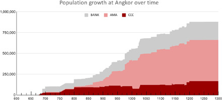
Fig. 3. Densities of people per hectare in the Greater Angkor Region over time.
For information on the density analysis see the Supplementary Materials.
Table 1. Population estimates, growth rate, and densities in the CCCs, BANKs, and AMA over time.
| Period | Date | Population | Growth rate* | Density† | |||||||||
| CCCs | AMA | BANKs‡ | Total | CCCs | AMA | BANKs | TOTAL |
CCC area |
AMA area (ha) |
CCC (p/ha) | AMA (p/ha) | ||
| 1 | 770–888 | 89,137 | 70,668 | 88,891 | 248,696 | – | – | – | – | 5847 | 294,153 | 15.2 | 0.2 |
| 2 | 889–1001 | 76,796 | 318,439 | 139,191 | 525,313 | −0.001 | 0.013 | 0.004 | 0.007 | 8498 | 291,502 | 13.8 | 1.1 |
| 3 | 1002–1112 | 117,288 | 431,181 | 183,399 | 761,663 | 0.004 | 0.003 | 0.003 | 0.003 | 3200 | 296,800 | 36.7 | 1.5 |
| 4 | 1113–1180 | 122,534 | 491,322 | 203,949 | 847,600 | 0.001 | 0.002 | 0.002 | 0.002 | 3868 | 296,132 | 31.7 | 1.7 |
| 5 | 1181–1300 | 159,852 | 497,949 | 216,215 | 903,811 | 0.002 | 0.000 | 0.000 | 0.001 | 4207 | 295,793 | 38.0 | 1.7 |
*Growth rate = (Natural log(Population 2) − Natural log(Population 1))/Number of years.
†Average density for the entire study area (3000 km2), divided between the CCCs and AMA (AMA includes BANKs).
‡The population of the embankment ranges from 0 to the numbers shown here.
At its 12th to13th century CE height, our model predicts that between 700,000 and 900,000 people inhabited the 3000-km2 Greater Angkor Region (Table 1). This range is due to uncertainty regarding variations in the density of occupation on the BANKs; it is likely that population density decreased farther from the CCCs. The lower end of this estimate is in line with a previous population estimate of 750,000 people based on the amount of rice that could have been produced in the region without irrigation (10). The economic catchment of the Greater Angkor Region is not clear, and inscriptions do not clearly state that provincial regions were provisioning the capital with additional food as populations increased (10). In the future, our model would benefit from research designed to quantify the economic linkages between the Greater Angkor Region and outlying provincial areas.
DISCUSSION
It is the integration of the AMA with the CCCs through water management infrastructure (BANKs) and transportation networks that makes Angkor a massive agro-urban complex (19, 21). Our models demonstrate, however, that population density varied across the site. Contrasting our models with other comparable preindustrial urban traditions in the tropics and subtropics suggests, for example, that while the range of AMA population densities (1.5 p/ha) are much lower than the estimated overall population densities of the agro-urban landscape at the Classic Maya city of Caracol at its 7th century CE peak (ca. 6 p/ha), approximately half of the space included in our analysis was not cultivated and may not have been occupied. Meanwhile, the CCCs have densities (~13 to 75 p/ha) that are consistent with Teotihuacan or Anyang (50 p/ha) (table S4) (see table S3 for further details and citations).
Distinguishing between CCC and AMA population density is vital for producing accurate population estimates that limit the impact of sampling bias. For example, CCC areas are often favored over metropolitan areas for intensive investigation when resources are limited (e.g., the high cost of acquiring lidar data or undertaking extensive surface surveys). This is true in the Greater Angkor Region, where the lidar surveys focused on the CCCs in more heavily vegetated terrain than the AMA, and has been true of many other archaeological lidar surveys of ancient cities and epicenters [e.g., (22)]. Hence, it is not appropriate to extrapolate the densities calculated in these areas across the entire sites. By considering different occupation zones, we provide a more nuanced approach to demographic analyses that accounts for variation in density across sites.
Combining multiple lines of data, we have been able to show the logistic growth of one of the world’s largest agro-urban center. Over several centuries, elites in the CCC zones developed a sprawling water management and transportation infrastructure that integrated much of the landscape, facilitating the growth of the population to perhaps up to 900,000 people in the 13th century. However, note that Angkor began its gradual decline shortly after reaching its apogee (23). Scholars have noted the fragility of such expensive urban systems (24); however, ongoing work suggests that the Angkor region was not completely depopulated (15, 25).
This study has demonstrated the dynamic nature of agro-urban settlements and provides a model for future comparative analyses. For example, we note that the CCC and AMA zones evolved at different times and independently of one another. Are such dynamics found in other low-density cities? The role of bottom-up land management within AMA communities may speak to the heterarchical social organization of these communities, as seen in other agro-urban settlements (19, 26). Future work could also further consider the role of migration, especially during period 5 when density in Angkor’s CCC was at its most intense [e.g., (27)]. We look forward to future studies that add further nuance to the rise of this urban form.
MATERIALS AND METHODS
Areas of occupation
We identify three primary areas of occupation at Angkor: the CCCs, the AMA, and the BANKs (fig. S10). In all zones, communities were established on earthen mounds and BANKs, which elevated residential areas from annual floodwater levels.
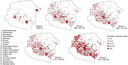
The CCCs encompass an overall area of 30 km2, including many of the massive stone temples for which Angkor is famous. Adding the older capitals of Mahendraparvata and Hariharālaya expands the CCCs to 75 km2 (Fig. 4). This urban core of Angkor included large populations associated with the royal court and the major religious institutions; traders; and specialized workforces of craftsmen, bureaucrats, and officials (28). The landscape of the CCCs is a complicated palimpsest representing many centuries of accumulated development. We have subdivided this landscape into 17 diachronic districts, named after their most prominent temple (Fig. 4 and figs. S1 to S8). For areas that were built over in subsequent periods, we drew from studies on the chronology of the urban core [e.g., (29)] to delimit the extent of the CCCs at different points in time.
Fig. 4. The sequential CCCs within the Greater Angkor Region.

There are 17 CCC zones within the Greater Angkor Region. Each zone is shown here, either as a polygon encompassing the features associated with each CCC (red) or an estimated area of CCCs that were built over in later time periods (black dotted).
In contrast to the CCCs, AMA temples do not have a high density of occupation mounds and are instead identified by a particular configuration known as prasat-trapeang (temple-reservoir) (19). These temples are known to be the center of Angkor period communities that were located on associated occupation mounds and whose inhabitants were engaged primarily in farming activities (30). More than 1100 of these configurations have been identified and mapped in the Greater Angkor Region (17).
A third form of occupation was on the BANKs of large water management features and roads. Evidence for occupation on the BANKs includes scatters of domestic debris such as ceramics on the surface and similar debris in the channels along with dark organic deposits (31). The communities that occupied these BANKs had access to trade opportunities along the roadways and were also able to access adjacent rice fields. As this state-sponsored infrastructural network of BANKs expanded across the Greater Angkor Region from the 9th to 13th centuries CE, it offered elevated land for housing that was not controlled by the long-established residential clusters associated with temple communities in the rice fields. The initial occupants on the BANKs may therefore have been people migrating into the city (31).
Dating the landscape
Intensive mapping projects over the past 30 years have led to a comprehensive map of the Greater Angkor Region (4–7, 32). The study area for this work encompasses an area of approximately 3000 km2, a somewhat arbitrary boundary that is based on the watershed catchment boundaries of Angkor’s rivers (4). The extent and density of settlement beyond this area is the subject of ongoing research, although it is clear that the low-density distribution of local temples extends in a wide arc across modern-day Cambodia, spanning many thousands of square kilometers beyond the Greater Angkor Region (4). To visualize diachronic change, we divided Angkor’s growth into five periods on the basis of major historical and infrastructural developments (see summary table S2).
Dating the CCC landscape
In the CCCs, temples are constructed of stone and brick and are often associated with inscriptions that give their consecration dates. Most temples without inscriptions have distinctive diagnostic architectural features that have been dated through reliable art historical stylistic analyses refined since the beginnings of scholarship on Angkor (33, 34). The chronological information that we used for this study can be found in data S1, including recalibrated 14C dates (see data S16 and S17 dates and the Supplementary Materials for methodology). Temples in the CCCs often have clear spatial, functional, and chronological relationships with grids of occupation mounds that surround them (6, 7, 13, 16). In our analyses, we gave these occupation mounds the same dates as the temples with which they were associated.
Dating the AMA landscape
Less than 10% of the temples in the AMA have been dated from inscriptions and art historical analyses. Using these dates and known attributes for the remaining temples (see data S1), dates for 1177 temples were predicted using multiple linear regression and a graph-based semisupervised machine learning algorithm with a 49- to 66-year average absolute error [see full discussion in (17)]. The dating method for each temple is listed in the “Notes” column of data S1.
In addition to more than 1100 temples and tens of thousands of occupation mounds that are scattered across the Greater Angkor Region, more than 3000 reservoirs are located in proximity (~1.5 km) to individual temples. Previous studies have used quantitative and qualitative assessments to establish spatial and functional relationships between these elements and to link collections of mounds, reservoirs, and local temples into groups. These groups are the fundamental building blocks of premodern settlement across much of Cambodia’s Lower Mekong basin (35, 36), including Angkor’s dispersed agro-urban landscape (9, 37–39). Using a dissimilarity formula incorporating proximity and orientation (see the Supplementary Materials for full discussion), we were able to group 2437 reservoirs with temples and assign dates accordingly (data S15; see also figs. S1 to S8).
Dating the BANKs
The BANKs and channels of the Greater Angkor Region were developed over time as elements in a series of networks that gathered, stored, and distributed water. Using the simple logic of the flow of water through the system, from higher areas to lower, we can reconstruct functional hydraulic networks with a reasonable degree of confidence, including systems to aggregate and disperse water from the vast moats and reservoirs of Angkor’s urban core. In addition to the lateral coherence of the network, changes were made to it over time, which produced superpositioning, from which we can identify relative chronological relationships and model the spatiotemporal development of the landscape. Some elements of the hydraulic network (e.g., the massive East Baray) can be dated from inscriptions, while other elements can be indirectly dated by their spatial and functional relationship with well-dated temples, providing chronological anchor points for major components of the network (see data S1) (40).
Last, for the CCCs, AMA, and BANKs, we assigned dates to features with unknown dates using a relative system of grouping features with other features that either date to the same time period or date to an earlier time period (see further discussion of the sorting algorithm in the Supplementary Materials). This allowed us to systematically associate otherwise undated features to features with dates, such as the BANKs of a channel with the date of the channel. It also allowed for inferential assessments of features based on relative spatial relationships. For example, if a mound was built over an embankment, then it is assumed that the mound was built after the embankment. In total, we recorded more than 30,000 of such relationships (Fig. 4 and data S3). There are over 30,000 mapped features in the Greater Angkor Region (data S2), and with the methods described above, we were able to determine dates for approximately 21,000 of these features (figs. S1 to S7).
Estimating population growth over time
Estimating population in the CCCs
To estimate the population of the CCCs over time, we first calculated the total area in square meters of mounded occupation features mapped on the modern ground surface in each CCC for each period including discrete mounds, pond BANKs, and linear BANKs (hereafter referred to as the “mound method”). Evidence suggests that Angkorians built dwellings on all such features (31). Houses in the Angkorian period, similar to those today, were raised on piles or stilts above the ground surface. In some cases, such as at Angkor Wat, mounds are discrete and of the same general size with a pond immediately next to it (13). On the basis of our 2015 excavations, A.K.C. believes that they likely contained a single household. In other cases, occupation mound spaces were larger and may have contained numerous households. In our mound method, we use Angkor Wat’s mounds, each approximately 20 m by 30 m (600 m2), as a proxy for the approximate size of a household in the Greater Angkor Region, with the 600-m2 surface area encompassing both a house structure and the surrounding living space. To estimate the number of households within the CCCs, we calculated the total square meters of mound and embankment features mapped on the modern ground surface in each CCC zone for each period and then divided this number by 600 m2 to approximate the total number of houses. We acknowledge that house size likely varied and that further excavations will refine our estimate for household size in different contexts (13). This method does not preclude the ability to conduct density analyses because earlier urban landscapes have more agricultural space among archaeological features than later urban landscapes (table S4 and fig. S3).
Population estimates were made using the household size of 600 m2 and ethnographic assumptions that each household consisted of five members (12, 41, 42). Zhou Daguan, a Chinese visitor to Angkor in 1296–1297, reported that from 10 to 100 slaves served many Angkorian households and lived under the houses or perhaps outside the city (43). No evidence of occupation under houses has yet been identified in excavations. If slaves had separate living quarters inside or outside the city, then this would be accounted for in our model.
Estimating population in the AMA
Mid-20th century AMA communities in Cambodia, similar to those of the Angkor period, were engaged in subsistence rice agriculture in seasonally inundated fields, in a period before the arrival of mechanization. They were typically organized in village-level units called phum, built on elevated earthen mounds, and have temple and reservoir (prasat-trapeang) configurations analogous to those of the Angkor period (16, 35, 42). Ethnographic reports indicate that these village-level temples serviced approximately 100 families (41).
Unfortunately, approximately half the occupation mounds surrounding AMA temples are missing or disturbed, likely because of their destruction for agricultural purposes. Because of the lack of preservation, we are unable to use the mound method to accurately estimate population as in the CCCs. In addition, archaeological studies indicate that rural community household spaces were larger than those in the CCCs (37), with occupation density increasing with proximity to the center of communities (41).
To provide spatial resolution to the temples with surviving occupation mounds, we adapted the method developed by Hanson and Ortman (44) to the 7216 occupation mounds that we can associate with AMA temple communities. This method builds on theoretical and cross-cultural empirical work, which suggests that, on average, the resident population of small and spatially unorganized settlements varies with area according to A = aN2/3, where A is the settlement area, N is the resident population, and a is a baseline area per person in the smallest settlements in a system (44). This relation can be rearranged to solve for population in terms of area, N = (1/a)3/2A3/2, to provide a means of estimating the population of an occupational mound based on its area and the baseline area per person in the smallest settlements.
Absent direct evidence for the value of a, we set this value so that the resulting mean population of temple communities across the dataset would match that of ethnohistoric Khmer communities (100 families with five people). We found that setting a = 0.05 led to a mean (497) at 623 temple communities, so we used this value to estimate the resident population of each occupational mound. With this method, the largest temple communities have fewer than 5000 people. We then estimated the total temple community populations by summing the resident populations of all mounds associated spatially with its central temple (see further explanation in the “Estimating AMA population” section in the Supplementary Materials). For temples without surviving occupation mounds, we assigned the mean population of 497 people.
These estimates are based on the terminus post quem (earliest potential date) of the temple. Without fine-grained analyses at each site, it is difficult to determine the length of occupation. Archaeological evidence suggests that smaller temples may have been replaced by or superseded by larger temples (37), which suggests that prime land held by small communities and non-elite families were frequently taken over by elites (20). Our model assumes that once founded, the associated temple populations remain on the landscape, even if their population was subsumed into that of a larger temple over time.
Estimating population on the BANKs
To calculate the population on the BANKs, we first measured the length of features. Our model assumes that the widest surviving part of the embankment is likely similar to the width of the embankment at the time of construction and that families were likely to be living on the BANKs at the same density as they were in the CCCs, with each household occupying approximately 600 m2 (See table S5 and data S4 to S14 for results). Preliminary surveys suggest that population density on the BANKs decreased with distance to the nearest CCCs. Consequently, we present the results of this analysis as a range until further research can be done to determine variable population density along the BANKs.
Acknowledgments
We wish to thank the APSARA National Authority for permission to conduct remote sensing and collaborative field investigations. We thank M. So and M. Dana for administrative support. We thank E. Lustig and T. Lustig for comments and suggestions on aspects of economic geography and M. E. Smith and C. Isendahl for reading and offering comments on an earlier draft of this paper. Funding: Much of the work on research, planning, and writing of this manuscript was undertaken with the support of the University of Oregon Global Oregon Faculty Collaboration Fund, supported by the Global Studies Institute in the UO Office of International Affairs. Parts of this research have been funded by the Rust Family Foundation, the Social Sciences and Humanities Research Council of Canada Postdoctoral Fellowship, the National Science Foundation Doctoral Dissertation Research Improvement Awards (no. 1638137), the ACLS-Robert H. N. Ho Family Foundation Program in Buddhist Studies, Australian Research Council Discovery Grant DP1092663, Australian Research Council Discovery Early Career Researcher Award DE150100756, Australian Research Council Discovery Grant DP170102574, and the European Research Council (ERC) under the European Union’s Horizon 2020 research and innovation programme (grant agreement nos. 639828 and 866454). Author contributions: S.K. and A.K.C. contributed to the planning of this research. S.K., A.K.C., M.H., and S.O. drafted the manuscript. S.K., A.K.C., D.E., M.T.S., M.P., G.P.M., R.F., and P.H. edited the manuscript. S.K., A.A.L., M.H., J.N.-W., D.E., P.W., and S.O. contributed to the analysis. S.K., A.K.C., P.H., and M.P. compiled the data. S.K., A.K.C., P.H., G.P.M., R.F., D.E., C.P., and M.P. contributed data. S.K., M.H., and A.A.L. designed the figures. All authors discussed the results and commented on the manuscript. Competing interests: The authors declare that they have no competing interests. Data and materials availability: All data needed to evaluate the conclusions in the paper are present in the paper and/or the Supplementary Materials. Additional data related to this paper maybe requested from the authors.
SUPPLEMENTARY MATERIALS
Supplementary material for this article is available at http://advances.sciencemag.org/cgi/content/full/7/19/eabf8441/DC1
REFERENCES AND NOTES
- 1.E. Graham, C. Isendahl, The Resilience of Heritage: Cultivating a Future of the Past. Essays in Honour of Professor Paul J.J. Sinclair, A. Ekblom, C. Isendahl, K.-J. Lindholm, Eds. (Uppsala University, 2018). [Google Scholar]
- 2.R. Fletcher, in The Archaeology of Complex Societies, M. E. Smith, Ed. (Cambridge Univ. Press, 2012), pp. 285–320. [Google Scholar]
- 3.Stark B. L., Urban gardens and parks in pre-modern states and empires. Camb. Archaeol. J. 24, 87–115 (2014). [Google Scholar]
- 4.Evans D., Pottier C., Fletcher R., Hensley S., Tapley I., Milne A., Barbetti M., A comprehensive archaeological map of the world’s largest preindustrial settlement complex at Angkor, Cambodia. Proc. Natl. Acad. Sci. U.S.A. 104, 14277–14282 (2007). [DOI] [PMC free article] [PubMed] [Google Scholar]
- 5.C. Pottier, “Carte archéologique de la region d’Angkor-Zone Sud,” thesis, Université Paris III Sorbonne Nouvelle, Histoire et archéologie du Monde Indien (1999). [Google Scholar]
- 6.Evans D., Airborne laser scanning as a method for exploring long-term socio-ecological dynamics in Cambodia. J. Archaeol. Sci. 74, 164–175 (2016). [Google Scholar]
- 7.Evans D. H., Fletcher R. J., Pottier C., Chevance J.-B., Soutif D., Tan B. S., Im S., Ea D., Tin T., Kim S., Cromarty C., De Greef S., Hanus K., Bâty P., Kuszinger R., Shimoda I., Boornazian G., Uncovering archaeological landscapes at Angkor using lidar. Proc. Natl. Acad. Sci. U.S.A. 110, 12595–12600 (2013). [DOI] [PMC free article] [PubMed] [Google Scholar]
- 8.H. Mouhot, Travels in Siam, Cambodia, Laos and Annam (White Lotus, 2000). [Google Scholar]
- 9.Groslier B.-P., VII. La cité hydraulique angkorienne: Exploitation ou surexploitation du sol? Bulletin de l’École française d’Extrême-Orient 66, 161–202 (1979). [Google Scholar]
- 10.E. Lustig, “Water and the transformation of power at Angkor, 10th to 13th centuries A.D.” thesis, University of Sydney (2001). [Google Scholar]
- 11.A. Chamberlain, Demography in Archaeology (Cambridge Univ. Press, 2006). [Google Scholar]
- 12.Hassan F. A., Demographic archaeology. Adv. Archeol. Method Theory 1, 49–103 (1978). [Google Scholar]
- 13.Carter A., Heng P., Stark M., Chhay R., Evans D., Urbanism and residential patterning in Angkor. J. Field Archaeol. 43, 492–506 (2018). [Google Scholar]
- 14.Fletcher R., Pottier C., The Gossamer city: A new inquiry. Museum Int. 54, 23–27 (2002). [Google Scholar]
- 15.Carter A. K., Stark M. T., Quintus S., Zhuang Y., Wang H., Heng P., Chhay R., Temple occupation and the tempo of collapse at Angkor Wat, Cambodia. Proc. Natl. Acad. Sci. U.S.A. 116, 12226–12231 (2019). [DOI] [PMC free article] [PubMed] [Google Scholar]
- 16.Stark M., Evans D., Rachna C., Piphal H., Carter A., Residential patterning at Angkor Wat. Antiquity 89, 1439–1455 (2015). [Google Scholar]
- 17.Klassen S., Weed J., Evans D., Semi-supervised machine learning approaches for predicting the chronology of archaeological sites: A case study of temples from medieval Angkor, Cambodia. PLOS ONE 13, e0205649 (2018). [DOI] [PMC free article] [PubMed] [Google Scholar]
- 18.Kintigh K. W., Altschul J. H., Beaudry M. C., Drennan R. D., Kinzig A. P., Kohler T. A., Limp W. F., Maschner H. D. G., Michener W. K., Pauketat T. R., Peregrine P., Sabloff J. A., Wilkinson T. J., Wright H. T., Zeder M. A., Grand challenges for archaeology. Am. Antiq. 79, 5–24 (2014). [DOI] [PMC free article] [PubMed] [Google Scholar]
- 19.Klassen S., Evans D., Top-down and bottom-up water management: A diachronic model of changing water management strategies at Angkor, Cambodia. J. Anthropol. Archaeol. 58, 101166 (2020). [Google Scholar]
- 20.Lustig E., Lustig T., Losing ground: Decline of Angkor’s middle-level officials. J. Southeast Asian Stud. 50, 409–430 (2019). [Google Scholar]
- 21.Hendrickson M., Historic routes to Angkor: Development of the Khmer road system (ninth to thirteenth centuries AD) in mainland Southeast Asia. Antiquity 84, 480–496 (2010). [Google Scholar]
- 22.Canuto M. A., Estrada-Belli F., Garrison T. G., Houston S. D., Acuña M. J., Kováč M., Marken D., Nondédéo P., Auld-Thomas L., Castanet C., Chatelain D., Chiriboga C. R., Drápela T., Lieskovský T., Tokovinine A., Velasquez A., Fernández-Díaz J. C., Shrestha R., Ancient lowland Maya complexity as revealed by airborne laser scanning of northern Guatemala. Science 361, eaau0137 (2018). [DOI] [PubMed] [Google Scholar]
- 23.Penny D., Hall T., Evans D., Polkinghorne M., Geoarchaeological evidence from Angkor, Cambodia, reveals a gradual decline rather than a catastrophic 15th-century collapse. Proc. Natl. Acad. Sci. U.S.A. 116, 4871–4876 (2019). [DOI] [PMC free article] [PubMed] [Google Scholar]
- 24.Lucero L. J., Fletcher R., Coningham R., From ‘collapse’ to urban diaspora: The transformation of low-density, dispersed agrarian urbanism. Antiquity 89, 1139–1154 (2015). [Google Scholar]
- 25.Castillo C. C., Polkinghorne M., Vincent B., Suy T. B., Fuller D. Q., Life goes on: Archaeobotanical investigations of diet and ritual at Angkor Thom, Cambodia (14th–15th centuries CE). Holocene 28, 930–944 (2018). [Google Scholar]
- 26.McIntosh S. K., Floodplains and the development of complex society: Comparative perspectives from the West African semi-arid tropics. Archaeol. Papers Am. Anthropol. Assoc. 9, 151–165 (1999). [Google Scholar]
- 27.Smith M. E., Peasant mobility, local migration and premodern urbanization. World Archaeol. 46, 516–533 (2014). [Google Scholar]
- 28.M. Coe, D. Evans, Angkor and the Khmer Civilization (Thames and Hudson, 2018). [Google Scholar]
- 29.J. Gaucher, in Deux Décennies de Coopération Archéologique Franco-Cambodgienne à Angkor, A. Beschaouch, F. Verellen, M. Zink, Eds. (Académie des Inscriptions et Belles-Lettres, 2017), pp. 27–41. [Google Scholar]
- 30.L. A. Sedov, in The Early State, H. Claessen, P. Skalnik, Eds. (Mouton Publishers, 1978), pp. 111–130. [Google Scholar]
- 31.Fletcher R. J., Barbetti M., Evans D., Than H., Sokrithy I., Chan K., Penny D., Pottier C., Somaneath T., Redefining Angkor: Structure and environment in the largest, low density urban complex of the pre-industrial world. Udaya 4, 107–121 (2003). [Google Scholar]
- 32.Chevance J.-B., Evans D., Hofer N., Sakhoeun S., Chhean R., Mahendraparvata: An early Angkor-period capital defined through airborne laser scanning at Phnom Kulen. Antiquity 93, 1303–1321 (2019). [Google Scholar]
- 33.M. Polkinghorne, Thesis. University of Sydney, Sydney (2007). [Google Scholar]
- 34.P. Stern, Le Bayon d’Angkor et l’évolution de l’art khmer: Étude et discussion de la chronologie des monuments khmers (Paul Geuthner, 1927).
- 35.Stark M. T., Pre-Angkorian settlement trends in Cambodia’s Mekong Delta and the Lower Mekong Archaeological Project. Bull. Indo-Pacific Prehistory Assoc. 26, 98–109 (2006). [Google Scholar]
- 36.Evans C., Chang N., Shimizu N., Sites, survey and ceramics: Settlement patterns of the first to ninth centuries CE in the Upper Mun River Valley, northeast Thailand. J. Southeast Asian Stud. 47, 438–467 (2016). [Google Scholar]
- 37.P. Bâty, “Extension de l’aéroport de Siem Reap 2004: Rapport de fouille archéologique,” APSARA-INRAP, Siem Reap–Paris, 2005.
- 38.Hawken S., Designs of kings and farmers: Landscape systems of the greater Angkor urban complex. Asian Perspect. 52, 347–367 (2013). [Google Scholar]
- 39.Pottier C., Some evidence of an inter-relationship between hydraulic features and rice field patterns at Angkor during ancient times. J. Sophia Asian Stud. 18, 99–120 (2000). [Google Scholar]
- 40.Penny D., Pottier C., Fletcher R., Barbetti M., Fink D., Hua Q., Vegetation and land-use at Angkor, Cambodia: A dated pollen sequence from the Bakong Temple Moat. Antiquity 80, 599–614 (2006). [Google Scholar]
- 41.J. Delvert, Le Paysan Cambodgien (Mouton, 1961), pp. 740. [Google Scholar]
- 42.M. M. Ebihara, Svay: A Khmer Village in Cambodia (Southeast Asia Program Publications, 2018). [Google Scholar]
- 43.Z. Daguan, A Record of Cambodia: The Land and its People (Silkworm Books, 2007). [Google Scholar]
- 44.Hanson J. W., Ortman S. G., A systematic method for estimating the populations of Greek and Roman settlements. J. Roman Archaeol. 30, 301–324 (2017). [Google Scholar]
- 45.G. Coedès, The Indianized States of Southeast Asia, S. B. Cowing, Ed. (The University of Hawaii Press, ed. 3, 1968). [Google Scholar]
- 46.C. Pottier, Under the Western Baray Waters. In Uncovering Southeast Asia’s Past: Selected Papers from the 10th International Conference the European Association of Southeast Asian Archaeologists, E. Bacus, I. C. Glover, V. C. Pigott, Eds. (NUS Press, Singapore, 2006), pp. 298–309. [Google Scholar]
- 47.Pottier C., Sachara P. V., Than H., Rachna C., Chan K., Demeter F., Koh Ta Méas, un site préhistorique dans le Baray occidental, Rapport préliminaire. Udaya 5, 167–191 (2004). [Google Scholar]
- 48.C. Pottier, in Deux Décennies de Coopération Archéologique Franco-Cambodgienne à Angkor, A. Beschaouch, F. Verellen, M. Zink, Eds. (Académie des Inscriptions et Belles-Lettres, 2017), pp. 43–80. [Google Scholar]
- 49.M. Vickery, Society, Economics, and Politics in Pre-Angkor Cambodia. The 7th and 8th Centuries (The Centre for East Asian Cultural Studies for Unesco, 1998). [Google Scholar]
- 50.C. Pottier, A. Bolle, E. Llopis, D. Soutif, C. Tan, J. B. Chevance, K. Vireak, C. Socheat, S. Sang, et al., “Mission Archéologique Franco-Khmère sur l’Aménagement du Territoire Angkorien (MAFKATA): Campagne 2005 Rapport,” Authority for the Protection and Management of Angkor and the Region of Siem Reap–Ministère des Affaires Étrangeres (France)–l’Ecole Française d’Extrême-Orient, Siem Reap, 2005.
- 51.Pottier C., Bolle A., Le Prasat Trapeang Phong à Hariharâlaya: Histoire d’un temple et archéologie d’un site. Aséanie 24, 61–90 (2009). [Google Scholar]
- 52.R. Fletcher, C. Pottier, The Oxford Handbook of Southeast Asian Archaeology, C. Higham, N. C. Kim, Eds. (Oxford Univ. Press, 2021). [Google Scholar]
- 53.C. Pottier, in The Buddhist Monastery: A Cross Cultural Survey, P. Pichard, F. Lagirarde, Eds. (École Français D’Extrême-Orient, 2003), pp. 199–208. [Google Scholar]
- 54.C. Jacques, in Phnom Bakheng Workshop on Public Interpretation, J. C. Chermayeff, Ed. (Center for Khmer Studies, 2005), pp. 23–40. [Google Scholar]
- 55.J. Dumarçay, The Site of Angkor (Oxford Univ. Press, 1998). [Google Scholar]
- 56.Polkinghorne M., Ideals and architects: Khmer Temple Pyramids (eighth to eleventh century). Aséanie 21, 65–88 (2008). [Google Scholar]
- 57.Buckley B. M., Anchukaitis K. J., Penny D., Fletcher R., Cook E. R., Sano M., Nam L. C., Wichienkeeo A., Minh T. T., Hong T. M., Climate as a contributing factor in the demise of Angkor, Cambodia. Proc. Natl. Acad. Sci. U.S.A. 107, 6748–6752 (2010). [DOI] [PMC free article] [PubMed] [Google Scholar]
- 58.R. Fletcher, B. Buckley, C. Pottier, S.-Y. S. Wang, in Megadrought and Collapse: From Early Agriculture to Angkor, H. Weiss, Ed. (Oxford Univ. Press, 2017), pp. 275–314. [Google Scholar]
- 59.Hall T., Penny D., Vincent B., Polkinghorne M., An integrated palaeoenvironmental record of Early Modern occupancy and land use within Angkor Thom, Angkor. Quat. Sci. Rev. 251, 106710 (2021). [Google Scholar]
- 60.B. L. Stark, in Making Ancient Cities: Space and Place in Early Urban Societies, A. T. Creekmore III, K. D. Fisher, Eds. (Cambridge Univ. Press, 2014), pp. 370–406. [Google Scholar]
- 61.Campbell R. B., Toward a networks and boundaries approach to early complex polities. Curr. Anthropol. 50, 821–848 (2009). [Google Scholar]
- 62.M. E. Smith, in Oxford Handbook of the Aztecs, D. L. Nichols, E. Rodríguez-Alegría, Eds. (Oxford Univ. Press, 2016), pp. 201–217. [Google Scholar]
- 63.Isendahl C., Smith M. E., Sustainable agrarian urbanism: The low-density cities of the Mayas and Aztecs. Cities 31, 132–143 (2013). [Google Scholar]
- 64.Milner G. R., Mississippian period population density in a segment of the central Mississippi River Valley. Am. Antiq. 51, 227–238 (1986). [Google Scholar]
- 65.T. R. Pauketat, Archaeological Perspectives on Political Economies, G. M. Feinman, L. M. Nicholas, Eds. (University of Utah Press, 2004). [Google Scholar]
- 66.Chirikure S., Moultrie T., Bandama F., Dandara C., Manyanga M., What was the population of Great Zimbabwe (CE1000 - 1800)? PLOS ONE 12, e0178335 (2017). [DOI] [PMC free article] [PubMed] [Google Scholar]
- 67.Chase A. F., Chase D. Z., Weishampel J. F., Drake J. B., Shrestha R. L., Slatton K. C., Awe J. J., Carter W. E., Airborne LiDAR, archaeology, and the ancient Maya landscape at Caracol, Belize. J. Archaeol. Sci. 38, 387–398 (2011). [Google Scholar]
- 68.Jansen M., Water supply and sewage disposal at Mohenjo-Daro. World Archaeol. 21, 177–192 (1989). [DOI] [PubMed] [Google Scholar]
- 69.J. M. Kenoyer, Ancient Cities of the Indus Valley Civilization (Oxford Univ. Press, 1998). [Google Scholar]
- 70.Cowgill G. L., State and society at Teotihuacan, Mexico. Annu. Rev. Anthropol. 26, 129–161 (1997). [Google Scholar]
- 71.Albert B., Innes J., Krementskiy K., Millard A. R., Gaydarska B., Nebbia M., Chapman J., What was the ecological impact of a Trypillia megasite occupation? Multi-proxy palaeo-environmental investigations at Nebelivka, Ukraine. Veg. Hist. Archaeobot. 29, 15–34 (2020). [Google Scholar]
- 72.R. M. Adams, Heartland of Cities. Surveys of Ancient Settlement and Land Use on the Central Floodplain of the Euphrates (University of Chicago Press, 1981). [Google Scholar]
- 73.APSARA Authority, “The celebration of the 20th anniversary of: Angkor being designated a World Heritage Site and International Co-ordinating Committee for the Safeguarding and Development of the Historic Site of Angkor (ICC),” Department of Conservation of Monuments in Angkor Park and Preventive Archaeology, Siem Reap, Cambodia, 2013.
- 74.C. Pottier, A. Guerin, H. Than, I. Sokrithy, L. Eric, K. Chan, “Mission Archéologique Franco-Khmère sur l’Aménagement du Territoire Angkorien (MAFKATA). Rapport sur la campagne de fouilles 2001,” Authority for the Protection and Management of Angkor and the Region of Siem Reap–Ministère des Affaires Étrangeres (France)–l’Ecole Française d’Extrême-Orient, Siem Reap, 2001.
- 75.E. Lustig, “Power and pragmatism in the political economy of Angkor,” thesis, University of Sydney, Sydney (2009). [Google Scholar]
- 76.Fletcher R., Pottier C., Evans D., Kummu M., The development of the water management system of Angkor: A provisional model. Bull. Indo-Pac. Prehist. Assoc. 28, 57–66 (2008). [Google Scholar]
- 77.E. Aymonier, in Le Cambodge: Le groupe d’Angkor et l’histoire. III (Ernest Leroux, 1904), vol. 3. [Google Scholar]
- 78.Y. Tabata, “The Banteay Kdei Temple. Preliminary report of the excavation at Banteay Kdei temple, 2010” (Sophia University, 2010).
- 79.Pottier C., Soutif D., De l’ancienneté de Hariharālaya. Une inscription préangkorienne opportune à Bakong. Bulletin de l’Ecole française d’Extrême-Orient 100, 147–166 (2014). [Google Scholar]
- 80.Greater Angkor Project, “Greater Angkor Project 2005–6 to 2010–11 Preliminary Report Series: Bam Penh Rach 2005–09,” Greater Angkor Project, Siem Reap, 2011.
- 81.Dagens B., History of the Angkor site. Museum Int. 54, 12–22 (2002). [Google Scholar]
- 82.Uchida E., Suda C., Ueno A., Shimoda I., Nakagawa T., Estimation of the construction period of Prasat Suor Prat in the Angkor monuments, Cambodia, based on the characteristics of its stone materials and the radioactive carbon age of charcoal fragments. J. Archaeol. Sci. 32, 1339–1345 (2005). [Google Scholar]
- 83.Leroy S., Hendrickson M., Delqué-Kolic E., Vega E., Dillmann P., First direct dating for the construction and modification of the Baphuon Temple Mountain in Angkor, Cambodia. PLOS ONE 10, e0141052 (2015). [DOI] [PMC free article] [PubMed] [Google Scholar]
- 84.Greater Angkor Project, “Greater Angkor Project 2005–6 to 2010–11 Preliminary Report Series: Phlau Krabay Februray 2006,” Greater Angkor Project, Siem Reap, 2011.
- 85.S. Sahai, The Hindu Temples in South East Asia: Their Role in Social Economic and Political Formations (Aryan Books, 2012). [Google Scholar]
- 86.S. Chea, “‘Saugatāśrama,’ Un āśrama bouddhique à Angkor (Ong Mong),” thesis, Université Paris-Sorbonne, Paris (2018). [Google Scholar]
- 87.E. Aymonier, Le Cambodge: Les Provinces Siamoises. II, Vol. 2 (Ernest Leroux, 1901). [Google Scholar]
- 88.Finot L., Inscriptions d’Ankor. Bulletin de l’Ecole française d’Extrême-Orient 25, 289–409 (1925). [Google Scholar]
- 89.E. Lunet de Lajonquiere, Inventaire Descriptif des Monuments du Cambodge. Tome Troisieme (Ernest Leroux, 1911). [Google Scholar]
- 90.Greater Angkor Project, “Greater Angkor Project 2011–2015 Preliminary Report Series: Spean Wat Preah Enkosei,” Greater Angkor Project, Siem Reap, 2012.
- 91.Greater Angkor Project, “Greater Angkor Project 2011–2015 Preliminary Report Series: Junction of Bakheng and Indratataka Embankments January 2012,” Greater Angkor Project, Siem Reap, 2012.
- 92.C. Jacques, P. Lafond, The Khmer Empire: Cities and Sanctuaries from the 5th to the 13th Century (River Books, 2007). [Google Scholar]
- 93.Greater Angkor Project, “Greater Angkor Project 2005–6 to 2010–11 Preliminary Report Series: West Mebon-central platform June 2005,” Greater Angkor Project, Siem Reap, 2011.
- 94.Maxwell T. S., The Stele inscription of Preah Khan, Angkor. Udaya J. Khmer Stud. 8, 1–114 (2007). [Google Scholar]
- 95.C. Pottier, A. Desbat, M.-F. Dupoizat, A. Bolle, in Orientalismes. De l’archéologie au musée. Mélanges offerts à Jean-François Jarrige, V. Lefevre, Ed. (Brepols, 2012), pp. 291–317. [Google Scholar]
- 96.C. Pottier, A. Bolle, A. Desbat, M.-F. Dupoizat, A. F. Mélanie, C. Socheat, P. Dara, P. C. Kosal, A. Vierstraete, E. Bruneau, M. Taing, A. Godin, A. Guerinet, “Mission Archéologique Franco-Khmère sur l’Aménagement du Territoire Angkorien (MAFKATA): Campagne 2008 Rapport,” Authority for the Protection and Management of Angkor and the Region of Siem Reap–Ministère des Affaires Étrangeres (France)–l’Ecole Française d’Extrême-Orient, Siem Reap, Cambodia, 2008.
- 97.C. Pottier, A. Bolle, A. Desbat, C. Socheat, M.-F. Dupoizat, A. Beuken, A. Vierstraete, E. Bruneau, D. Penny, “Mission Archéologique Franco- Khmère sur l’Aménagement du Territoire Angkorien (MAFKATA): Campagne 2009 Rapport,” Authority for the Protection and Management of Angkor and the Region of Siem Reap–Ministère des Affaires Étrangeres (France)–l’Ecole Française d’Extrême-Orient, Siem Reap, Cambodia, 2009.
- 98.M. Hendrickson, T. Sonnemann, S. Player, “Angkorian Dharmasala Project 2008 Preliminary Report Series: Prasat Sampou January 2008,” Angkorian Dharmasala Project, Siem Reap, 2008.
- 99.J. Dumarçay, P. Royere, M. T. Smithies, Cambodian Architecture: Eighth to Thirteenth Centuries (Brill, 2001). [Google Scholar]
- 100.C. Pottier, A. Guerin, H. Than, I. Sokrithy, K. Tchan, L. Eric, “Mission Archéologique Franco-Khmère sur l’Aménagement du Territoire Angkorien (MAFKATA). Rapport sur la campagne de fouilles 2000,” Authority for the Protection and Management of Angkor and the Region of Siem Reap–Ministère des Affaires Étrangeres (France)–l’Ecole Française d’Extrême-Orient, Siem Reap, 2001.
- 101.C. Pottier, “Carte archéologique de la region d’Angkor Zone Sud,” thesis, Université Paris III—Sorbonne Nouvelle, Paris (1999). [Google Scholar]
- 102.G. Cœdès, Inscriptions du Cambodge, VIII (EFEO, 1966). [Google Scholar]
- 103.J. Gaucher, P. Husi, Archéologie de l’espace urbain, E. Lorans, X. Rodier, Eds. (Presses universitaires François-Rabelais, 2013). [Google Scholar]
- 104.J. Boisselier, Le cambodge. Manuel d’archéologie d’extrême-orient, asie du sud-est (A. et J. Picard et Cie, 1966).
- 105.Estève J., Soutif D., Les Yasodharàsrama, marqueurs d’empire et bornes sacrées: Conformité et spécificité des stèles digraphiques khmères de la région de Vat Phu. Bulletin de l’École française d’Extrême-Orient 97-98, 331–355 (2010). [Google Scholar]
- 106.Cœdès G., A la recherche du Yaçodhāraçrama. Bulletin de l’École française d’Extrême-Orient 32, 71–112 (1932). [Google Scholar]
- 107.A. M. Bergaigne, Inscriptions sanscrites de Campā et du Cambodge (Imprimerie Nationale, 1893). [Google Scholar]
- 108.C. Pottier, A. Guérin, “Mission Archéologique Franco-Khmère sur l’Aménagement du Territoire Angkorien (MAFKATA): Campagne 2002 Rapport,” Authority for the Protection and Management of Angkor and the Region of Siem Reap–Ministère des Affaires Étrangeres (France)–l’Ecole Française d’Extrême-Orient, Siem Reap, 2002.
- 109.NARA National Research Institute for Cultural Properties, “APSARA Authority, Survey and Restoration of Western Prasat Top Interim Report 5 Brick Structure of Northern Sanctuary 2018,” National Institutes for Cultural Heritage, Nara City, 2018.
- 110.Greater Angkor Project, “Greater Angkor Project 2011–2015 Preliminary Report Series: Kok Phnov 2012,” Greater Angkor Project, Siem Reap, 2012.
- 111.Greater Angkor Project, “Greater Angkor Project 2002–2005 Preliminary Report Series: Veal Nak Tha January–February 2005,” Greater Angkor Project, Siem Reap, 2005.
- 112.M. Hendrickson, T. Sonnemann, S. Player, “Angkor Dharmasala Report 2008 Preliminary Report Series: Prasat Phtu January 2008,” Angkor Dharmasala Project, Siem Reap, 2008.
- 113.D. J. Brotherson, thesis, University of Sydney, Sydney (2011). [Google Scholar]
- 114.J. Boisselier, in Studies on the Art of Ancient Cambodia. Ten Articles by Jean Boisselier, N. Eilenberg, R. L. Brown, Eds. (Reyum Publishing, 2010), pp. 68–150. [Google Scholar]
- 115.P. Courbin, in Documents graphiques de la Conservation d’Angkor, J. Dumarçay, Ed. (EFEO, 1988), pp. 20–58. [Google Scholar]
- 116.O. Cunin, in Bayon, New Perspectives, J. Clark, Ed. (River Books, 2007), pp. 136–229. [Google Scholar]
- 117.Greater Angkor Project, “Greater Angkor Project 2011–2015 Preliminary Report Series: Wat Athvea July 2012,” Greater Angkor Project, Siem Reap, 2012.
- 118.Greater Angkor Project, “Greater Angkor Project 2011–2015 Preliminary Report Series: Wat Athvea West June 2013,” Greater Angkor Project, Siem Reap, 2013.
- 119.Greater Angkor Project, “Greater Angkor Project 2011–2015 Preliminary Report Series: July 2011 Field Season Report,” Greater Angkor Project, Siem Reap, 2011.
- 120.Greater Angkor Project, “Greater Angkor Project 2002–2007 Preliminary Report Series: Krol Romeas January/July 2007,” Greater Angkor Project, Siem Reap, 2007.
- 121.Greater Angkor Project, “Greater Angkor Project 2005–6 to 2010–11 Preliminary Report Series: Thnal Putrea April 2006,” Greater Angkor Project, Siem Reap, 2011.
- 122.Malleret L., III. Ouvrages circulaires en terre dans l’Indochine méridionale. Bulletin de l’École française d’Extrême-Orient 49-2, 409–434 (1959). [Google Scholar]
- 123.O’Reilly D., Shewan L., Domett K., Sopheap A., Revisiting Prei Khmeng: The excavation of an iron age settlement and cemetery in Cambodia. Asian Perspect. 59, 33–60 (2020). [Google Scholar]
- 124.O’Reilly D., Shewan L., Phum Lovea: A moated precursor to the pura of Cambodia? Sociopolitical transformation from Iron Age settlements to early state society. J. Southeast Asian Stud. 47, 468–483 (2016). [Google Scholar]
- 125.Polkinghorne M., Vincent B., Thomas N., Bourgarit D., Casting for the king: The royal palace bronze workshop of Angkor Thom. Bulletin de l’École française d’Extrême-Orient 100, 327–358 (2014). [Google Scholar]
- 126.Polkinghorne M., Douglas J. G., Carò F., Carving at the Capital: A stone workshop at Hariharālaya, Angkor. Bulletin de l’École française d’Extrême-Orient 101, 55–90 (2015). [Google Scholar]
- 127.Pou S., VI. Inscriptions en Khmer Moyen de Vat Athvea (K. 261). Bulletin de l’École française d’Extrême-Orient 64, 151–166 (1977). [Google Scholar]
- 128.S. Tep, “Final report on ceramics conservation from Kok Patri temple,” APSARA National Authority, Siem Reap, 2011.
- 129.Uchida E., Cunin O., Shimoda I., Takuho Y., Nakagawa T., AMS radiocarbon dating of wood samples from the Angkor Monuments, Cambodia. Radiocarbon 50, 437–445 (2008). [Google Scholar]
- 130.M. Vickery, in Bayon, New Perspectives, J. Clark, Ed. (River Books, 2007), pp. 10–27. [Google Scholar]
- 131.M. Vickery, in The Khmer Inscriptions of Roluos (Preah Ko and Lolei): Documents from a Transitional Period in Cambodian History (Seksa Khmer, 1999), no. 1, pp. 48–89.
- 132.M. T. Stark, A. K. Carter, R. Chhay, P. Heng, “Greater Angkor Project July 2011 Field Season Report,” Greater Angkor Project, Siem Reap, 2011.
- 133.M. T. Stark, A. K. Carter, R. Chhay, P. Heng, “Report on the February–March 2012 GAP III Field Season,” Greater Angkor Project, Siem Reap, 2012.
- 134.Cœdès G., L’épigraphie des monuments de Jayavarman VII. Bulletin de l’École française d’Extrême-Orient 44-1, 97–120 (1951). [Google Scholar]
- 135.Cœdès G., IV. La stèle du Práh Khằn d’Ankor. Bulletin de l’École française d’Extrême-Orient 41, 255–302 (1941). [Google Scholar]
- 136.C. Pottier, A. Bolle, D. Soutif, A. Desbat, M.-F. Dupoizat, A. F. Mélanie, J.-B. Chevance, K. Vireak, P. C. Kosal, P. Dara, A. Vierstraete, E. Bruneau, K. Chmielczyk, “Mission Archéologique Franco-Khmère sur l’Aménagement du Territoire Angkorien (MAFKATA): Campagne 2007 Rapport,” Authority for the Protection and Management of Angkor and the Region of Siem Reap–Ministère des Affaires Étrangères (France)–l’Ecole Française d’Extrême-Orient, Siem Reap, Cambodia, 2007.
- 137.Greater Angkor Project, “Greater Angkor Project 2011–2015 Preliminary Report Series: Kok Roka, near Boat site, June–July 2013,” Greater Angkor Project, Siem Reap, 2013.
- 138.Greater Angkor Project, “Greater Angkor Project 2011–2015 Preliminary Report Series: Kok Ta Kong January 2012,” Greater Angkor Project, Siem Reap, 2012.
- 139.Pottier C., La restauration du perron nord de la terrace des Éléphants à Angkor Thom. Rapport sur la première année de travaux (avril 1996-avril 1997). Bulletin de l’Ecole française d’Extrême-Orient 84, 376–401 (1997). [Google Scholar]
- 140.L. P. Briggs, The Ancient Khmer Empire. Trans. Am. Philos. Soc. 41, part 1 (1951). [Google Scholar]
- 141.Penny D., Zachreson C., Fletcher R., Lau D., Lizier J. T., Fischer N., Evans D., Pottier C., Prokopenko M., The demise of Angkor: Systemic vulnerability of urban infrastructure to climatic variations. Sci. Adv. 4, eaau4029 (2018). [DOI] [PMC free article] [PubMed] [Google Scholar]
- 142.Kim N. C., Lasting monuments and durable institutions: Labor, urbanism, and statehood in Northern Vietnam and beyond. J. Archaeol. Res. 21, 217–267 (2013). [Google Scholar]
Associated Data
This section collects any data citations, data availability statements, or supplementary materials included in this article.
Supplementary Materials
Supplementary material for this article is available at http://advances.sciencemag.org/cgi/content/full/7/19/eabf8441/DC1