

Abstract
This article examines how GIS can be used as a heuristic tool to reconstruct spatial–temporal events from narratives in order to examine whether a scenario is conceivable within the narrative world. The narrative about Paul's escape from Berea (Acts 17:14–15) is used as a case study. Several interpretive issues related to spatial and temporal questions surround these texts. In the case study, three methods are applied: (a) least‐cost path analysis on elevation data to construct journeys and travel times for Roman roads; (b) network analysis to find seafaring routes valid for ancient times; and (c) the integration of spatial and temporal data in a space‐time cube. Our main finding is that the method yields insights into the spatial–temporal dynamics of the narrative. This helps a modern reader to better understand the narrative conceivability of a story in the mind of a first‐century reader.
1. INTRODUCTION
Narratives from ancient times can be used to reconstruct events in the distant past. However, on many occasions, the original sources of the narratives are not directly available. Moreover, the narratives often served other purposes than merely describing events, which challenges the reconstructing of history. In this article, we study how to use GIS as a heuristic tool to aid the reconstruction of spatial–temporal events from narratives. This will advance the interpretation of ancient historiography.
The structure of this article will be as follows: after a literature review of the way GIS is applied for narrative interpretation, and an overview of earlier applications of spatiotemporal research for New Testament interpretation, a case study will be introduced (i.e., the narrative in Acts 17:14–15). Subsequently, GIS will be used to create reconstructions of what might have happened in history. These reconstructions will be evaluated based on their viability in the overall context of the narrative of Acts, testing what fits the established events and the contemporary physical geography of the book of Acts. The final section will evaluate the findings.
2. LITERATURE REVIEW
This section discusses narrative criticism, geo narrative analysis, cartographic reconstructions of historical and literary events, and previous work to reconstruct New Testament narratives.
Narrative criticism is a method of text interpretation in the tradition of reader‐response criticism, which views a text as an organic structure of both content and form. The method focuses on the ultimate form of a text and scrutinizes its rhetoric, characters, point of view, plot, and setting (Osborne, 1993; Powell, 1991; Resseguie, 2005).
Multiple researchers have attempted to map personal and literary narratives. Kwan (2008) applied geo narrative analysis to map the personal post‐9‐11 experiences of an American Muslim. Kraak (2014) modeled Napoleon's march to and return from Moscow and unleashed new insights into the dramatic losses of the French army in the winter of 1812 using conventional cartographic techniques as well as sophisticated 3D modeling. For the more literary realms, Rose (2019) applied GIS to analyze character perspectives in Tolkien's Lord of the Rings, and Hill (2014) mapped all the geographical locations in the works of Mark Twain. Travis (2015) applied GIS to the conquest and mapping of 17th‐century Ireland, to the works of Kavanagh, and to measure the influence of Homer's Odyssey and Dante's Inferno on Joyce's Ulysses.1
Recently, spatial analysis has been introduced to the domain of New Testament studies. Larsen and Benzek (2014, 2016, 2017) use GIS as a geo‐hermeneutical tool to equate travel movements in the book of Acts with the geographical picture derived from Pauline letters. Fousek, Kaše, Mertel, Výtvarová, and Chalupa (2018) study the expansion of early Christianity using a gravity model, and Wilson (2009, 2016, 2018a, 2018b) uses GIS to reconstruct the route of Paul's travels. van Altena, Bakker, and Stoter (2018) scrutinize a list of nations in Acts 2:9–11, applying cartographic comparison, network analysis, and spatiotemporal analysis.
Reconstructing the geography from a literary source has caveats. Juvan (2015) warns for naive mimetic materialism: “A cartographic representation of fictional settings […] placed on the base map of a real geospace” could be misleading, wrongly identifying the fictional places with a position in the perceived world and as such distorting the analysis of the spatial picture inside the narrative. However, conscious use of these tools might help to discover possible dissimilarities between the referential, imaginative world inside the text and the referenced, empirical world, and can highlight issues for further research. We will experiment with this in a case study.
3. CASE STUDY: A RECONSTRUCTION OF ACTS 17:14–15
The second half of the Acts of the Apostles, the fifth book in the New Testament, describes the ramblings of the apostle Paul. Paul is first portrayed as the great persecutor of the early Christian movement, but his portrait changes drastically to that of an itinerant missionary, being persecuted himself. Within this larger narrative framework of what traditionally is coined “Paul's missionary journeys”, we find an episode taking place in the ancient regions of Macedonia and Achaea.
After Paul had been called in a dream by a Macedonian man to come over to the European mainland from Troas, Paul traveled the Via Egnatia, visiting the Roman colony of Philippi and Thessalonica. Soon, however, he had to flee by night since his life was endangered due to fierce opposition stirred up by Thessalonian Jews. After escaping, Paul arrived at Berea where the local Jewish community was willingly investigating his message. Again the situation changed very quickly when Thessalonian Jews arrived in the city and started agitating the crowds. The narrative continues:
“Then the brothers immediately sent Paul off on his way to the sea, but Silas and Timothy remained there. Those who conducted Paul brought him as far as Athens, and after receiving a command for Silas and Timothy to come to him as soon as possible, they departed.” (Acts 17:14–15; ESV, 2016)
After an intermezzo about Paul's stay and speech to Epicurean and Stoic philosophers on the Areopagus in Athens, Paul proceeded from Athens to Corinth (Acts 18:1). Here Silas and Timothy reunite with the apostle (Acts 18:5).
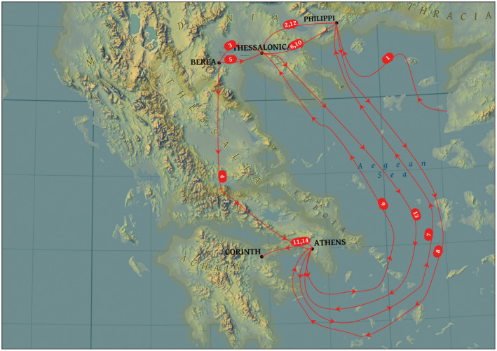
At first sight the narrative in Acts provides a coherent picture of the events that happened during Paul's second missionary journey, which is smoothly mapped in many popular bible atlases (see Figure 1).2
FIGURE 1.

Suggested routes for Paul's flight from Berea
Upon a closer look, it appears to be less straightforward to create a map from the narrative. This is due to two interpretive issues: Paul's route to Athens (Section 3.1) and the ambiguity of the travels of his companions (Section 3.2).3
3.1. Paul's route to Athens
Concerning Paul's route from Berea to Athens (17:14), there is an ongoing discussion whether Paul and his escort embarked on a ship at the coast of the Aegean Sea and sailed in 3–4 days to Athens,4 or went over land to Athens, which would have taken 12–21 days.5 Multiple facets influence the differences in interpretation. First, the difficulty of establishing the wording of the Greek text. Three textual variants exist which indicate the travel direction, and these could be rendered respectively as “to the sea,”6 “as it were to the sea,”7 and “as far as the sea.”8 The first and second variant, respectively, convey the idea of journeying by sea or land, while the third variant is ambivalent in its meaning. Unfortunately, textual evidence, grammar, and idiom do not offer conclusive evidence for either a land or sea journey.9
Therefore, interpreters resorted to complementary argumentation. Clues were found in what the text is omitting: intermediate stations might be suspected when journeying over land.10 However, such an argumentum e silentio is not valid: Olshausen (1860) remarks that Acts leaves whole regions “unnoticed, through which Paul passed and where he certainly laboured.” Furthermore, Clark ([1933] 1970) and Witherington (1998) observed that the narrative is also silent about the possible port of embarkation,11 which might be taken as evidence against a sea journey.
The safety argument similarly runs both ways. Multiple scholars see an allusion to a land journey in that Paul was conducted to Athens by an envoy,12 and some added that this would require protection and care.13 Stokes (1908) and Carver (1916) infer from 1 Thess. 2–3 that Paul was in a bad physical and mental condition, which would have required a rapid departure. Schnabel (2019) suggests that “it might have seemed advisable not to take a ship to Athens, which involved the possibility of encountering enemies.” Hemer (1990), however, posits that “opponents might be expecting” Paul on the land route. Therefore, it would have been safer to embark on a ship, especially if Paul's companions wanted to get him away from the scene to a different jurisdiction as soon as possible.14
Keener (2014) also comments that sea travel would have required fares. Schnabel (2019) infers from this that the phrase “those who escorted Paul” in Acts 17:15 might suggest travel by land. But this is not decisive. Traveling over land would take considerably more time than a sea journey, and being away for a long time would require housing and food expenses. Either way, Pervo (2009) correctly concludes that “these persons had the resources to send an escort … all the way to Athens.”
3.2. The travel movements of Paul's companions
The travel movements of Paul's companions are another source of conjecture, especially when some verses from Paul's letters are interpreted as referring to the same event:
“Therefore […] we were willing to be left behind at Athens alone, and we sent Timothy […] But now that Timothy has come to us …” (1 Thess. 3:1–2a and 6; ESV, 2016)
Meyer (1870) and, more recently, Lüdemann (1984, 1989) claimed that it is impossible to harmonize these verses with Acts 17:14–15. However, these accounts are not necessarily excluding each other.15 The reconstruction of the travels of Paul and his companions is, however, challenged by the sparse data available in the book of Acts and the Pauline letters.16 Multiple reconstructions have been offered, which sometimes simply summarize the narrative in Acts,17 while others try to harmonize Acts with 1 Thessalonians. In the remainder of this article, we will investigate three reconstructions more closely.18
3.2.1. First reconstruction
According to the traditional reconstruction of Kirsopp Lake (1911) (see Figure 2), Paul, Silas, and Timothy traveled from Troas over Philippi [1] and Thessalonica [2] to Berea [3].19 When Paul is again assaulted by Thessalonian Jews, he leaves Silas and Timothy behind in Berea and goes to Athens, under the escort of Berean brethren [4 or 5]. From there, the escort returns to Berea [6] with a message for Silas and Timothy to join Paul as soon as possible (Acts 17:14–15).
FIGURE 2.

Lake's reconstruction
From 1 Thess. 3:1, Lake infers that Silas and Timothy joined Paul in Athens [7]. Timothy is immediately sent to Thessalonica [8] and Silas somewhere else in Macedonia [10] (1 Thess. 3:1–5, not in Acts).20 After both companions returned to Macedonia, Paul finishes his short stay in Athens and relocates to Corinth ([9]; cf. Acts 18:1).
Silas starts traveling again (from Philippi?) and reunites with Timothy in Thessalonica [11]. Together they travel from Macedonia, probably over Athens [12] to Corinth [13], and there they reunite with Paul (Acts 18:5; 1 Thess. 3:6).
3.2.2. Second reconstruction
A second reconstruction (which follows Lake's sequence for [1–5]) is offered by de Zwaan (1948): Timothy (and probably Silas) may never have been in Athens (see Figure 3). Instead, while Paul himself is in Athens, he gives his envoy orders to return to Berea [6] with a message for Timothy and Silas to go from Berea to Thessalonica [8] and Philippi [9], respectively. Paul meanwhile traversed from Athens to Corinth [7], and Silas and Timothy were expected to come as quickly as possible after they had completed their tasks [10–12].
FIGURE 3.

De Zwaan's reconstruction
In this view, there is no necessity for a meeting between Timothy, Silas, and Paul in Athens.21
3.2.3. Third reconstruction
More recently, Meers (1993) developed another reconstruction (see Figure 4). Two days after leaving Troas by boat, Paul, Silas, Timothy, and Luke arrive in Philippi [1] (cf. Acts 16:12ff.). Paul is imprisoned together with Silas. After their release, Paul and Silas continue their travels to Thessalonica [2] and Berea [3], leaving Timothy and Luke behind in Philippi. When Paul is again assaulted by Thessalonian Jews, he leaves Silas behind in Berea and goes over land to Athens, under the escort of Berean brethren [4].
FIGURE 4.
Meers' reconstruction
Meanwhile, Silas returns from Berea, over Thessalonica [5] to Philippi [6], and reunites with Timothy (and Luke). After some time, the escort of Berean brethren returns from Athens and arrives in Philippi [7] with a message for Silas and Timothy to join Paul as soon as possible.
Silas and Timothy travel from Philippi to Athens [8]. Shortly after their arrival Paul sends them back to Thessalonica [9], where Timothy stays. Silas, however, immediately continues his travel to Philippi [10].
Paul then moves on from Athens to Corinth [11] and starts a ministry there. Then Silas returns from Philippi to Thessalonica [12], collects Timothy and together they travel probably over Athens [13] to Corinth [14], where they reunite with Paul.
4. DATA, METHODS, AND EXPERIMENTS
In the remainder of this article we will study the narrative conceivability of these reconstructions using spatial–temporal technology: our aim is not to establish what actually happened in history, but to examine whether a scenario is conceivable within the narrative world for the model reader.22 The narrative world is the world as outlined in the story. A story (even a fairy tale or a science‐fiction story) must be consistent and meet certain laws to be credible for the reader. The model reader is the reader that the author had in mind when writing the story and an author will assume certain knowledge, while he will explain other data in detail for his implied reader.23 In the story in Acts 17–18, such assumed knowledge would for example be a general impression of distances and duration. In other words, the model reader would have been able to create a mental map from the story. For us modern readers, it might be difficult to create a mental map from the narrative. Our geographical knowledge of the Greco‐Roman world is limited, as is our understanding of the time traveling involved.
To assess the narrative conceivability of the scenarios in Section 3.2, we created a spatial–temporal model, using the methods outlined in Figure 5. Besides ingredients like locations24 and elevation data,25 the spatial–temporal model is built from reconstructed journeys over land and by sea (Section 4.1), and temporal data (Section 4.2).
FIGURE 5.

Overview of methods, data, and sources
4.1. Method and data to reconstruct journeys
A few digital road datasets and network analysis tools exist for the Roman roads, but these are unfortunately not suitable for our spatial analysis. Exemplary is the Roman road dataset provided by the Ancient World Mapping Center (2012), which has two disadvantages: the roads have been digitized from a generalized 1:1 M map, which negatively affects the positional accuracy. Moreover, these data do not contain information about travel time. And although ORBIS, the sophisticated Stanford Geospatial Network Model of the Roman World (Scheidel & Meeks, n.d.), contains multi‐modal travel time information for the Roman world, this tool is not usable (the set of available cities to travel to and from is too limited and the network's coverage of the Greek peninsula is very sparse).
Therefore, we used ArcGIS Pro algorithms for least‐cost path analysis (LCPA) to estimate the trajectory of Roman roads.26 Input for the calculation was a list of origin–destination pairs including coordinates, digital elevation rasters, and Tobler's anisotropic hiking function (Tobler, 1993). This formula takes the ratio between elevation and speed into account and estimates travel time in hours. Factors like soil condition, temperature, and availability of water would also influence the speed of hiking, but were left out of the analysis. However, the results of the analysis were corrected for daylight, breaks, and lodging by assuming a maximum of 8 hr hiking per day.27
The account of Acts follows road stations on the Via Egnatia (a Roman road evidenced by milestones) for the trajectory in Macedonia, between Philippi and Thessalonica. Intermediate road stations, lacking in the narrative in Acts, but necessary to create a finer course, were easily retrieved from Talbert and Bagnall (2000, map 50) and used as origin–destination pairs for LCPA. For the next trajectory, between Thessalonica and Berea, a coastal and a domestic route existed and either option would have taken 2 days (LCPA estimates 16 hr). We selected the domestic route since it partly followed the Via Egnatia.
As has already been discussed, the mode of travel between Berea and Athens is disputed. To reach Athens from Berea over land, three routes have been suggested (see Figure 6).28 These routes can be split into four trajectories and agree on the sections from Berea to Larissa, and from Lamia to Thronion.29 For the trajectory from Larissa to Lamia, two options have been suggested: a domestic route via Pharsallos30 or a coastal route.31 Only the coastal route is evidenced by milestones (Wittke et al., 2012, p. 196, Karte B). For the final trajectory between Thronion and Athens also, a coastal route32 and a domestic route have been suggested.33 We used the route suggested by Schnabel to create a list of origin–destination pairs as input for our LCPA.
FIGURE 6.

Suggested routes over land from Berea to Athens
LCPA is not suitable to establish the routes Paul and his companions could have taken over sea. For that reason we returned to the Stanford Geospatial Network Model of the Roman World (Scheidel & Meeks, n.d.).34 The web version has some issues for sea routes (i.e., a limited set of ports) and yielded some biased results, for instance for the route from Philippi to Athens. Therefore, it was unsuitable for our analysis. We downloaded the Orbis network data from its GitHub repository (Grossner, 2018) and pre‐processed them for application within ArcGIS Pro's Network Analyst. Furthermore, we created links to the network for the ports of Methone, Pydna, Dion, and the isle of Samothrace. Finally, we created a set of origin–destination pairs for each sea journey and used Network Analyst to establish the fastest route. The edgy geometries of the yielded routes have been used in all analyses, but were smoothed for the cartographic presentation.
4.2. Duration, dating, and possible timeframe
The previous section established a possible spatial reconstruction of the events. These results can be used to construct a (tentative) temporal framework. Besides these spatial data, this reconstruction is based upon data about the available time slot, travel duration, and the inferred duration of stays.
4.2.1. Available time slot
Dating the events in Acts is a study in itself, and reconstructions are tentative.35 The available timeframe for the texts under scrutiny can only be inferred by conflating sparse information from the text with archaeological findings and references from classical literature. Table 1 shows an example of a reconstruction of the events (Schnabel, 2004, p. 46).
TABLE 1.
Reconstruction of Paul's mission in Macedonia and Achaia
| Location | Period |
|---|---|
| Troas | Aug 49 CE |
| Philippi | Aug–Oct? 49 CE |
| Thessalonica | Oct–Dec 49 CE |
| Berea | Dec 49 CE/Jan? 50 CE |
| Athens | ? |
| Corinth | Feb/Mar 50 to Sep 51 |
The possible timeframe in which the events could have happened has to be based on a relative chronology: the date before which the events must have occurred (the terminus ad quem) is set by Paul's arrival in Corinth. This can roughly be dated to February/March 50, although this is not undisputed.36 The date after which the events must have happened (the terminus post quem) is set to the moment when Paul must have left Troas (August 49 CE). This date is even more difficult to establish and based on inferences itself. These termini provide a time slot of 189 days between August 1, 49 CE and March 31, 50 CE for Paul's mission in Macedonia and Achaia.
4.2.2. Duration of travels
The next step in creating the temporal framework is to establish the required travel time. Table 2 summarizes the length and duration for the trajectories we have established for the land journeys with LCPA, as well as the optimal sea travels we detected with network analysis. We assumed that sea travels could have been continuous (24 hr/day), while land journeys would have required breaks for food and lodging. Therefore, we assume a maximum of 8 hr journeying over land, which might of course have been dispersed over the day.
TABLE 2.
Trajectories including distance and duration
| Trajectory | Origin | Destination | Mode | Km | Hours | Days |
|---|---|---|---|---|---|---|
| 1 | Athens | Pydna | Sea | 479 | 71.0 | 3.0 |
| 2 | Athens | Thessalonica | Sea | 504 | 73.6 | 3.1 |
| 3 | Athens | Neapolis | Sea | 450 | 71.9 | 3.0 |
| 4 | Athens | Corinth | Land | 85 | 17.7 | 2.2 |
| 5 | Berea | Thessalonica | Land | 78 | 15.6 | 1.9 |
| 6 | Berea | Pydna | Land | 40 | 8.2 | 1.0 |
| 7 | Neapolis | Philippi | Land | 15 | 3.2 | 0.4 |
| 8 | Neapolis | Athens | Sea | 547 | 95.6 | 4.0 |
| 9 | Philippi | Thessalonica | Land | 160 | 32.6 | 4.1 |
| 10 | Philippi | Neapolis | Land | 15 | 3.2 | 0.1 |
| 11 | Pydna | Athens | Land | 475 | 98.5 | 12.3 |
| 12 | Pydna | Athens | Sea | 511 | 85.4 | 3.6 |
| 13 | Pydna | Berea | Land | 40 | 8.2 | 1.0 |
| 14 | Thessalonica | Berea | Land | 78 | 15.7 | 2.0 |
| 15 | Thessalonica | Philippi | Land | 160 | 32.6 | 4.1 |
| 16 | Thessalonica | Athens | Sea | 552 | 90.2 | 3.8 |
| 17 | Troas | Neapolis | Sea | 290 | 36.8 | 1.5 |
Paul's movements are especially relevant for a reconstruction. His departure from Troas and arrival at Corinth limit the available time, and the explicit sequence of his journeys in Acts can be used to calculate the available time for stays: 189 days are available for all travel and stays. The duration of Paul's travels (i.e., trajectories 17, 7, 9, 14, 6, 11, and 4; see Table 2) amount to approximately 22 days, which should be corrected for three Sabbaths.37
4.2.3. Inferred duration of stays
The time available for residence is 164 days (189 − 25 days). Acts describes how Paul visited Philippi, Thessalonica, Berea, and Athens on the road to Corinth, but is rather vague about the durations.38 Therefore, the duration of the individual stays can only be conjectured.
Usually, a very short duration of 14 days is assumed for Paul's stay in Athens. This still provides enough time for the journeys from and to Athens39 in Meers' and Lake's scenarios.40 For Philippi, Thessalonica, and Berea, we assume 8, 8, and 5 weeks, respectively. Other distributions are possible.
5. RESULTS
From the data presented in Sections 3 and 4, we constructed a sequence of events41 to integrate the spatial–temporal aspects of our case study in a 3D visualization. We used information about position and duration of journeys (Sections 3.2, 4.1, and Table 2) and residences (Section 4.2) to visualize a scenario in a space‐time cube (STC).42 The x‐ and y‐axes of the cube represent geography, the third dimension represents time. This enabled us to evaluate the feasibility of Lake's, Meers', and de Zwaan's scenarios (see Figures 7, 8, 9).
FIGURE 7.

Space‐time cube for Lake's scenario
FIGURE 8.

Space‐time cube for de Zwaan's scenario
FIGURE 9.
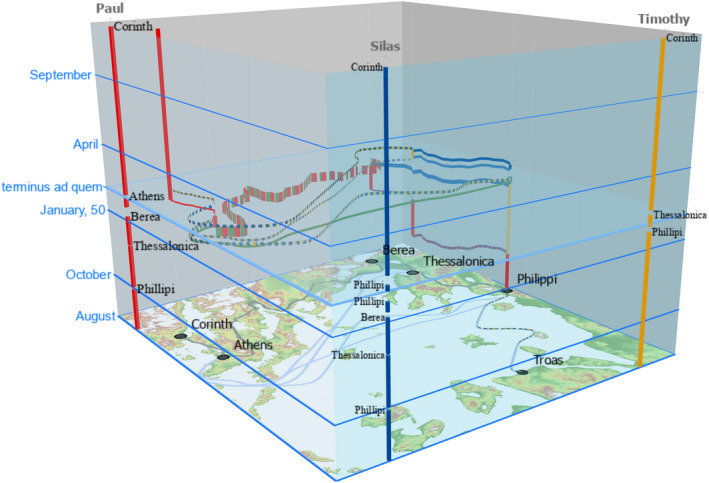
Space‐time cube for Meers' scenario
The presented reconstructions are tentative and should be interpreted with caution. Data about the Greco‐Roman world are not as precise as we would require for current‐day analyses, and many of the applied analyses are based on assumptions and mere conjecture.43 However, for a historian, accustomed to dealing with ambivalent material, open ends, and frayed edges in the reconstruction of history, the method provided insights that otherwise would be hard to beget.
Considering Paul's mode of traveling from Berea to Athens, we cannot be decisive. Both options are conceivable within the given timeframe. The issue is still open and either option has pro‐ and counter‐arguments.
Our spatial–temporal analysis did not deliver any objections to harmonize the events in Acts 17:14–15 with the events in 1 Thess. 3. On the contrary, the visualization in an STC yielded valid results for all three scenarios within the set time slot, as can be concluded from Figures 7, 8, 9. Since the temporal indications are sparse in the text and the movements of especially Paul's companions are vague, we cannot choose a particular scenario for what has happened in history.
This may seem disappointing, but is a valuable hermeneutical key to unlock a text for interpretation, as our case study on Acts 17:14–15 demonstrated. The author of Acts was clearly not interested in accurately reconstructing all travel movements of all characters. Instead, he lays emphasis on the repeating hostility to Paul's message. Going into full details might rather distract the reader from this emphasis.
6. CONCLUSION
This article studied how GIS can be used as a heuristic tool to aid the reconstruction of spatial–temporal events from narratives and used Acts 17:14–15 as a case study. Several interpretative issues were identified from the literature. The information in the text about locations and travels was translated into spatial–temporal information using LCPA, network analysis, and three different scenarios were eventually used to create STCs. Though these spatial–temporal models do not produce decisive pointers to interpret the stories (all scenarios appear to be possible), the method yields insights into the spatial–temporal dynamics of the narrative. This geo‐hermeneutic helps the modern reader to better understand the narrative conceivability of a story in the mind of a first‐century reader.
ACKNOWLEDGMENTS
Jantien Stoter has received funding from the European Research Council (ERC) under the European Union's Horizon 2020 research and innovation program (Grant/Award Number: 677312 UMnD).
van Altena V, Krans J, Bakker H, Stoter J. GIS as a heuristic tool to interpret ancient historiography: A case study to reconstruct what could plausibly have happened according to the accounts in New Testament texts. Transactions in GIS. 2021;25:1193–1212. 10.1111/tgis.12762
ENDNOTES
More examples, i.a., can be found in Bodenhamer (2008), Owens et al. (2009), Bodenhamer, Corrigan, and Harris (2010), Yuan (2010), Dear (2011), Bodenhamer, Harris, and Corrigan (2013), Caquard (2013), von Lünen and Travis (2013), Caquard and Cartwright (2014), da Silveira (2014), Gregory and Geddes (2014), Bodenhamer, Corrigan, and Harris (2015), Gregory, Cooper, Hardie, and Rayson (2015), Juvan (2015), Juvan and Dokler (2015), Yuan, McIntosh, and Delozier (2015), and Travis and von Lünen (2016).
Even the Historischer Atlas der Antiker Welt (Wittke, Olshausen, & Szydlak, 2012, p. 228), which is overall well researched, follows the portrayal of popular bible atlases.
Since there is an enormous amount of literature on these topics, we are referring to the earliest source we have identified for a particular argument.
Wieseler (1848), for instance, estimates the travel by ship at 3 days. Carver (1916) at 4 days. These estimations exclude the first part of the journey over land to reach the harbor, cf. Schnabel (2012).
Hackett (1859) estimated the land route at 250 miles (402 km), which would take 12 days. Schnabel (2014, 2016, 2017) deviates with an estimation of 320 miles (515 km) and 21 days.
The Western tradition reads “ἐπὶ τὴν θάλασσαν.”
The Byzantine tradition reads “ὡς ἐπὶ τὴν θάλασσαν” and indicates a route over land. Neander (1832) interpreted this as implying a ruse to confuse Paul's pursuers, but Alexander (2009, 2016, 2018a, 2018b) remarks: “As it were is in Greek a single word (ὡς) strictly meaning as, but often used by the best prose writers, with the preposition following it here (ὡς ἐπὶ), to signify the mere direction in which any thing or person moves, or at most the design to move in that direction. The full force of the phrase may be, to journey as (he must if he would get) to the sea. This idiom is so common in Thucydides, Polybius and Xenophon, that it cannot be considered as implying an intention to elude pursuit, by seeming to go to the sea, but really journeying by land.” The Greek grammars of Winer (1855, p. 544) and Moulton, Howard, and Turner (1963, p. 361) mention the confusion of ὡς and ἕως and the ambiguity in translation.
The Alexandrian tradition has ἕως ἐπὶ τὴν θάλασσαν, which is grammatically the hardest reading and found in more ancient manuscripts.
The reconstruction of the Greek text is always a process of weighing arguments. In this particular case, the UBS committee argues for the Alexandrian tradition, which is grammatically the hardest reading and found in more ancient manuscripts (Metzger, 1994). Meers (1993), however, argues for the Byzantine tradition.
Already in 1527, Erasmus mentions the issue: “Incertum est autem an Paulus Athenas pervenerit navigio an itinere pedestri. Nisi quod probabilius est eum navigavisse, vel quia refertur deductus ad mare, vel quia nulla mentio fit eorum quae Paulus in itinere gesserit, cui fuerant tot civitates peragrandae, quum ille non soleat ullam civitatem transire tacitus, nisi forte solus et collegis destitutus tacuit” (Erasmus & Hovingh, 2003, p. 282, ll. 380–385). ET, JK: “It is uncertain whether Paul arrived at Athens by boat or by land. Yet it is more likely that he sailed, either because he is reported to have been taken to the sea, or because nothing is said about the things Paul did on the way, though he had to travel through so many cities and was not used to traverse any city in silence, unless perhaps he kept silent because he was alone and without companions.” Wieseler (1848) adds that some of these stations were “eben so groß… wie Amphipolis und Apollonia.”
οἱ δὲ καθιστῶντες… ἤγαγον αὐτὸν; so e.g., Olshausen (1860). Keener (2014) agrees that this might refer to a land journey, but he prefers a sea journey on other grounds. Wendt (1888), however, sees support for a sea journey in the use of καθιστάναι in Homer, Od. 13, p. 274: “τοὺς μʼ ἐκέλευσα Πίλονδε καταστῆσαι.” ET: “I bade them take me aboard and land me at Pylos.”
Larkin (1995).
A hasty pattern can also be recognized in Acts 8:13, 25; cf. Zeller (1854), who remarks that Luke is often a “flüchtigen Erzähler.”
To further complicate the reconstruction, there is a textual variant which adds “He moved on past Thessaly, for he was prevented from preaching the Word to them” (Acts 17:15; cf. Haenchen, 1971, p. 509 and Pervo, 2009, pp. 417, 422). Additionally, this led to more conjecture, presupposing an undocumented corruption of the text in Acts 17:14, which wants to read ΘΕΣΣΑΛΙΑΝ (thessalian, Thessaly) for ΘΑΛΑΣΣΑΝ (thallassan, sea); cf. Krans and Peerbolte (2016) on Acts 17:14.
Brisco (1998, pp. 247–248), Curtis (2007, p. 167), and Currid and Barrett (2010, p. 244) simply follow the events as described in Acts 17:14–15: leaving Timothy and Silas behind in Berea, Paul flees to Athens. Immediately after arriving, he urges them to rejoin him there.
This is not to say that these are the only three possible reconstructions, but most of the suggestions offer a variation to Lake and revolve about the question of whether Timothy and Silas might have traveled together or apart from each other; cf. Neander (1832), Hackett (1859), and McNeile and Williams (1953). In the latter case that would require more travels over the similar trajectories, but this does not involve the sequence of the cities.
The text is not clear about the ramblings of Timothy, since it is not explicitly stated that he traveled along with Paul and Silas. Some scholars, therefore, assume that he remained behind in Philippi and reunited later on with the traveling party in Thessalonica or Berea; cf. Gloag (1870), Bisping (1871), Keulers (1937), and especially Zahn (1919), who assume that Timothy acted as liaison between Paul and the church of Philippi and traveled between Philippi, Thessalonica, and Berea.
De Zwaan (1948, p. 156), Williams (1957, p. 199), Marshall (1980, p. 297), Bock (2007, p. 557), and Wright (2012, p. 244) conjecture that Paul sent Silas probably to Philippi.
Gloag (1870) also mentions Timothy's absence in Athens as an option to reconcile the accounts of Acts and 1 Thessalonians. Alexander (1857), Strack and Böckler (1894), and Wendt (1913) suppose that Paul must have changed his mind and sent a letter to Timothy with orders to travel to Thessalonica instead of Berea. More recently, Donfried (2002) questioned on philological grounds that Timothy ever had been in Athens.
Narrative world and model reader are terminology employed by narrative criticism; cf. Powell (1991) and Resseguie (2005).
“Many texts make evident their Model Readers by implicitly presupposing a specific encyclopedic competence” (Eco, 1984, p. 7).
Besides coordinates for the locations mentioned in Acts, we also retrieved positional data from the Pleiades project (Bagnall et al., 2006) for geographical features mentioned in reference works. Pleiades is nowadays a partaker in the Pelagios network (Pelagios, 2021). The network focuses on semantic annotation of texts and artefacts to link and explore historical place information. Pelagios employs a linked open‐data model to stimulate collaboration on and sharing of sources. Besides the conceptual difference in data modeling, our research also distinguishes itself from Pelagios in its aim to use geographical data and tools to interpret ancient historiography, while Pelagios wants to provide methods and tools for data discovery and information retrieval about ancient places.
Digital elevation rasters in 30‐m resolution retrieved from the Shuttle Radar Topography Mission (SRTM) Elevation Dataset (U.S. Geological Survey, 2002).
We followed Section B: Anisotropic time estimate using path distance from Tripcevich and Johnson (2015).
Wilson (2018b). Although Paul was escaping and therefore may have walked more hours a day, he did not have modern ultra‐lightweight equipment and tools, which might have slowed him down.
Clark ([1933] 1970) and Barrett (1998) suggests a trajectory from Berea, over Pydna, Dion, Larissa, Demetrias, Opus, Chalcis, Thebes, Oropus, to Athens. Weiss (1899) and Haenchen (1971) suggested Berea, Larissa, Lamia, Elateia, Thebes and Athens. Schnabel (2019) suggests Berea, Pydna, Dion, Heracleion, Homolion, Gonnoi, Larissa, Pherai, Pyrasos, Halos, Pteleon, Antrones, Echinus, Lamia, Thermopylae, Alpenos, Nikaia, Thronion, Elateia, Parapotamioi, Panopeos, Chaeroneia, Lebadeia, Coronea, Haliartos, Thebes, Potniai, Tanagra, Aphidna, Oeum Deceleicum, Athens.
The LCPA‐trajectories for each proposal coincide more or less for this trajectory.
Clark ([1933] 1970), Barrett (1998), and Schnabel (2019). Although Schnabel has a much more detailed reconstruction than Clark and Barrett, he shortcuts the road between Pherai and Pyrasos, omitting the attested road via Demetrias.
Clark ([1933] 1970) and Barrett (1998). Although there is evidence for a Roman road for this trajectory, the proposal is problematic: Chalcis on the isle of Euboea is not accessible over land and Oropus lies way out of the direction to reach Athens. Moreover, LCPA approximates a length of 221 km and a travel time of 47 hr against the trajectory suggested by Schnabel (196 km and 41 hr).
Weiss (1899), Haenchen (1971), and Schnabel (2019). Weiss and Haenchen do not seem sufficiently aware of ancient geography, since a direct journey from Orchomenos to Thebes was impossible in ancient times. Lake Copais was not drained before the end of the 19th century, which disqualifies Orchomenos as an intermediate station. Schnabel offers two possibilities to reach Tanagara from Thebes. The route over Potniai would have been approximately 27 km and might have taken 5.6 hr. The route over Skolos 24.2 km and 5.1 hr. In subsequent analysis we will use the shorter Skolos variant.
The only source for sea travel is itineraries. The Orbis network used modern knowledge about, for instance, wind directions, wave heights, and sailing speed, and projected this on the classical Mediterranean world.
For an explanation of the issues, the articles of Alexander (1993) and Donfried (1992) are helpful.
To establish the latest possible date of the events of Paul's 18‐month stay in Corinth, an inscription which mentions the reigning period of Gallio (Acts 18:12) is used. Suggestions vary between early 50 CE to mid‐summer 51 CE (Barrett, 1998, lvi; Keener, 2014, pp. 2761–2763), fall 50 CE to spring 52 CE (Bruce, 1988, p. 351; Witherington, 1998, p. 551), and early 51 CE to summer 52 CE (Fitzmyer, 1998, pp. 622–623). This dating is dependent on the period in which Gallio was proconsul in Achaia, which since the discovery of the Gallio inscription is usually dated to 51 or maybe 52 CE, and of the moment when Paul was brought before the proconsul (Acts 18:12), which is usually situated at the end of Paul's stay in Corinth. Dating the events between September 51 CE and March 53 CE (Ramsay, 1895, p. 226) is obsolete since the discovery of the Gallio inscription.
A pious Jew would not have traveled on the sabbat; cf. Keener (2012).
It is disputed whether something can be concluded about the time Paul stayed in Thessalonica from Acts 17:2, especially since 1 Thessalonians gives the impression of a longer period of Paul's residence in the town; cf. Pervo (2009, p. 418) or Keener (2014, p. 2539).
For de Zwaan's scenario this is not an issue, since there is no meeting in Athens.
Meers: (a) Paul's escort to Philippi (3.1 days) and (b) Paul's companions from Philippi to Athens (4.1 days). Lake: (a) Paul's escort to Berea (4.3 days) and (b) Paul's companions from Berea to Athens (4.6 days).
Each sequence consists of residences and travels. The sequences are (a) Lake: Troas–1{17, 7}–Philippi–2{9}–8{2}–Thessalonica–9{15}–Philippi–10{4}–Corinth–11{9}–12{16}–13{4}–Corinth; (b) de Zwaan: Troas–1{17, 7}–Philippi–2{9}–Thessalonica–8{15}–Philippi–9{4}–Corinth–10{9}–11{16}–12{4}–Corinth; (c) Meers: Troas–1{17, 7}–Philippi–2{9}–Thessalonica–3{14}–Berea–{5}–{14}–4{6, 11}–5{5}–6{15}–Philippi–Athens–7{2, 7}–8{10, 8}–9{2}–Thessalonica–10{15}–Philippi–11{4}–Corinth–12{9}–13{16}–14{4}–Corinth. The numbers in braces {} represent the trajectories in Table 2 needed for travel.
Hägerstrand (1970) proposed the space‐time cube to visualize and analyze geographic and temporal aspects of data simultaneously. A noteworthy example is the 3D reconstruction of Napoleon's raid on Moscow (Kraak, 2014).
Though Tobler's hiking formula might yield to positive figures for speed, that would not render any of the three reconstructions impossible. Likewise, the durations of individual stays are completely based on conjecture, but that makes them very flexible to adjust.
DATA AVAILABILITY STATEMENT
The data that support the findings of this study are available from the corresponding author upon reasonable request.
REFERENCES
- Alexander, J. A. (1857). The Acts of the Apostles: Explained (Vol. 2). New York, NY: Scribner. [Google Scholar]
- Alexander, L. C. A. (1993). Chronology of Paul. In Hawthorne G. F., Martin R. P., & Reid D. G. (Eds.), Dictionary of Paul and his letters (pp. 115–123). Downers Grove, IL: InterVarsity Press. [Google Scholar]
- Ancient World Mapping Center . (2012). Roads dataset. Chapel Hill, NC: Ancient World Mapping Center. [Google Scholar]
- Bagnall, R., Talbert, R. J. A., Bond, S., Becker, J., Elliott, T., Gillies, S., … Turner, B. (Eds.). (2006). Pleiades: A community‐built gazetteer and graph of ancient places. Retrieved from http://pleiades.stoa.org [Google Scholar]
- Barrett, C. K. (1998). A critical and exegetical commentary on the Acts of the Apostles: International critical commentary. London, UK: T&T Clark. [Google Scholar]
- Bisping, A. (1871). Erklärung der Apostelgeschichte: Vol. 4, Exegetisches Handbuch zum Neuen Testament. Münster, Germany: Aschendorff. [Google Scholar]
- Bock, D. L. (2007). Acts: Baker exegetical commentary on the New Testament. Grand Rapids, MI: Baker Academic. [Google Scholar]
- Bodenhamer, D. J. (2008). History and GIS: Implications for the discipline. In Knowles A. K. & Hillier A. (Eds.), Placing history: How maps, spatial data, and GIS are changing historical scholarship (pp. 219–234). Redlands, CA: Esri Press. [Google Scholar]
- Bodenhamer, D. J., Corrigan, J., & Harris, T. M. (Eds.). (2010). The spatial humanities: GIS and the future of humanities scholarship. Bloomington, IN: Indiana University Press. [Google Scholar]
- Bodenhamer, D. J., Corrigan, J., & Harris, T. M. (Eds.). (2015). Deep maps and spatial narratives: The spatial humanities. Bloomington, IN: Indiana University Press. [Google Scholar]
- Bodenhamer, D. J., Harris, T. M., & Corrigan, J. (2013). Deep mapping and the spatial humanities. International Journal of Humanities and Arts Computing, 7(1–2), 170–175. 10.3366/ijhac.2013.0087 [DOI] [Google Scholar]
- Brisco, T. V. (1998). Holman Bible atlas: A complete guide to the expansive geography of biblical history. Nashville, TN: Broadman & Holman. [Google Scholar]
- Bruce, F. F. (1988). The Book of the Acts (Rev. ed.): New international commentary on the New Testament. Grand Rapids, MI: Eerdmans. [Google Scholar]
- Caquard, S. (2013). Cartography I: Mapping narrative cartography. Progress in Human Geography, 37(1), 135–144. 10.1177/0309132511423796 [DOI] [Google Scholar]
- Caquard, S., & Cartwright, W. (2014). Narrative cartography: From mapping stories to the narrative of maps and mapping. The Cartographic Journal, 51(2), 101–106. 10.1179/0008704114Z.000000000130 [DOI] [Google Scholar]
- Carver, W. O. (1916). The Acts of the Apostles. Nashville, TN: Broadman. [Google Scholar]
- Clark, A. C. ([1933] 1970). The Acts of the Apostles: A critical edition with introduction and notes on selected passages. Oxford, UK: Clarendon. [Google Scholar]
- Currid, J. D., & Barrett, D. P. (2010). Crossway ESV Bible atlas. Wheaton, IL: Crossway. [Google Scholar]
- Curtis, A. (2007). Oxford Bible atlas (4th ed.). Oxford, UK: Oxford University Press. [Google Scholar]
- da Silveira, L. E. (2014). Geographic information systems and historical research: An appraisal. International Journal of Humanities and Arts Computing, 8(1), 28–45. 10.3366/ijhac.2014.0118 [DOI] [Google Scholar]
- de Zwaan, J. (1948). Inleiding tot het Nieuwe Testament: Evangeliën en Handelingen (2nd ed.). Haarlem, the Netherlands: Bohn. [Google Scholar]
- Dear, M. J. (Ed.). (2011). Geohumanities: Art, history, text at the edge of place. London, UK: Routledge. [Google Scholar]
- Donfried, K. P. (1992). Chronology: New Testament. In Freedman D. N., Herion G. A., Graf D. F., Pleins J. D., & Beck A. B. (Eds.), The Anchor Yale Bible dictionary (pp. 1:1010–1:1022). New York, NY: Doubleday. [Google Scholar]
- Donfried, K. P. (2002). Paul, Thessalonica and early Christianity: Labour law and the public procurement process (Chapter 10 – Was Timothy in Athens? Some exegetical reflections on 1 Thess. 3‐1‐3). Bloomsbury, UK: T&T Clark. [Google Scholar]
- Dunn, J. D. G. (2016). The Acts of the Apostles. Grand Rapids, MI: Eerdmans. [Google Scholar]
- Eco, U. (1984). The role of the reader: Explorations in the semiotics of texts. Bloomington, IN: Indiana University Press. [Google Scholar]
- Erasmus, D., & Hovingh, P. E. (2003). Opera Omnia Desiderii Erasmi Roterodami Recognita et Adnotatione Critica Instructa Notisque Illustrata (Vol. 6 – Ordinis Sexti Tomus Sextus, Annotationes in Novum Testamentum Pars Secunda). Oxford, UK: Elsevier. [Google Scholar]
- Fitzmyer, J. A. (1998). The Acts of the Apostles. New York, NY: Doubleday. [Google Scholar]
- Fousek, J., Kaše, V., Mertel, A., Výtvarová, E., & Chalupa, A. (2018). Spatial constraints on the diffusion of religious innovations: The case of early Christianity in the Roman Empire. PLoS ONE, 13(12), e0208744. 10.1371/journal.pone.0208744 [DOI] [PMC free article] [PubMed] [Google Scholar]
- Gloag, P. J. (1870). A critical and exegetical commentary on the Acts of the Apostles: Vol. 2, International critical commentary. Edinburgh, UK: T&T Clark. [Google Scholar]
- Gregory, I., Cooper, D., Hardie, A., & Rayson, P. (2015). Spatializing and analyzing digital texts: Corpora, GIS and places. In Bodenhamer D. J., Corrigan J., & Harris T. M. (Eds.), Deep maps and spatial narratives (pp. 150–178). Bloomington, IN: Indiana University Press. [Google Scholar]
- Gregory, I. N., & Geddes, A. (Eds.). (2014). Toward spatial humanities: Historical GIS and spatial history. Bloomington, IN: Indiana University Press. [Google Scholar]
- Grossner, K. (2018). Orbis source code and data (Version 2). Retrieved from https://github.com/sul‐cidr/orbis_pub [Google Scholar]
- Hackett, H. B. (1859). A commentary on the original text of the Acts of the Apostles (2nd ed.). Boston, MA: Gould & Lincoln. [Google Scholar]
- Haenchen, E. (1971). The Acts of the Apostles: A commentary (Translated by B. Noble, G. Shinn, H. Anderson, & R. McL. Wilson). Philadelphia, PA: Westminster. [Google Scholar]
- Hägerstrand, T. (1970). What about people in regional science? Papers of the Regional Science Association, 24(1), 6–21. 10.1007/BF01936872 [DOI] [Google Scholar]
- Hemer, C. J. (1990). The Book of Acts in the setting of Hellenistic history. Winona Lake, IN: Eisenbrauns. [Google Scholar]
- Hill, A. W. (2014). The complete works of Mark Twain mapped. Retrieved from https://andrewxhill.com/maps/writers/twain/index.html [Google Scholar]
- Juvan, M. (2015). From spatial turn to GIS‐mapping of literary cultures. European Review, 23(1), 81–96. 10.1017/S1062798714000568 [DOI] [Google Scholar]
- Juvan, M., & Dokler, J. (2015). Towards a GIS analysis of literary cultures: The making of the Slovenian ethnoscape through literature. International Journal of Humanities and Arts Computing, 9(2), 196–218. 10.3366/ijhac.2015.0149 [DOI] [Google Scholar]
- Keener, C. S. (2012). Acts: An exegetical commentary – Introduction and 1:1–2:47 (Vol. 1). Grand Rapids, MI: Baker Academic. [Google Scholar]
- Keener, C. S. (2014). Acts: An exegetical commentary – 15:1–23:35 (Vol. 3). Grand Rapids, MI: Baker Academic. [Google Scholar]
- Keulers, J. (1937). Handelingen der Apostelen. Roermond, the Netherlands: Romen & Zonen. [Google Scholar]
- Kraak, M.‐J. (2014). Mapping time: Illustrated by Minard's map of Napoleon's Russian Campaign of 1812. Redlands, CA: Esri Press. [Google Scholar]
- Krans, J., & Peerbolte, B. J. L. (2016). The Amsterdam database of New Testament conjectural emendation. Retrieved from http://ntvmr.uni‐muenster.de/nt‐conjectures [Google Scholar]
- Kwan, M.‐P. (2008). From oral histories to visual narratives: Re‐presenting the post‐September 11 experiences of the Muslim women in the USA. Social & Cultural Geography, 9(6), 653–669. 10.1080/14649360802292462 [DOI] [Google Scholar]
- Lake, K. (1911). The earlier epistles of St. Paul: Their motive and origin. London, UK: Rivingtons. [Google Scholar]
- Larkin, W. J., Jr. (1995). Acts (Vol. 5). Downers Grove, IL: IVP Academic. [Google Scholar]
- Larsen, L. I., & Benzek, S. (2014). Min(d)Ing the gaps: Exploring ancient landscapes through the lens of GIS. Transformations: The Journal of Inclusive Scholarship and Pedagogy, 25(1), 45–58. 10.1353/tnf.2014.0003 [DOI] [Google Scholar]
- Larsen, L. I., & Benzek, S. (2016). Min(d)Ing the gaps: Digital refractions of ancient texts. In Clivaz C., Dilley P., & Hamidovic D. (Eds.), Ancient worlds in digital culture (pp. 128–147). Leiden, the Netherlands: Brill. [Google Scholar]
- Larsen, L. I., & Benzek, S. (2017). Mapping religiously, or religiously minding the map? In Brunn S. & Dodge M. (Eds.), Mapping across academia (pp. 323–347). Dordrecht, the Netherlands: Springer. [Google Scholar]
- Lüdemann, G. (1984). Paul, apostle to the Gentiles: Studies in chronology. Minneapolis, MN: Fortress. [Google Scholar]
- Lüdemann, G. (1989). Early christianity according to the traditions in Acts: A commentary (1st ed.). Minneapolis, MN: Fortress. [Google Scholar]
- Marshall, I. H. (1980). Acts: An introduction and commentary (Vol. 5). Downers Grove, IL: InterVarsity Press. [Google Scholar]
- McNeile, A. H., & Williams, C. S. C. (1953). An introduction to the study of the New Testament (2nd rev. ed.). Oxford, UK: Clarendon. [Google Scholar]
- Meers, A. (1993). Who went where and how? A consideration of Acts 17:14. The Bible Translator, 44(2), 201–206. 10.1177/026009439304400201 [DOI] [Google Scholar]
- Metzger, B. M. (1994). A textual commentary on the Greek New Testament, a companion volume to the United Bible Societies' Greek New Testament (4th Rev. Ed.) (2nd ed.). London, UK: United Bible Societies. [Google Scholar]
- Meyer, H. A. W. (1870). Kritisch‐exegetisches Handbuch über die Apostelgeschichte (4th ed.). Göttingen, Germany: Vandenhoeck & Ruprecht. [Google Scholar]
- Moulton, J. H., Howard, W. F., & Turner, N. (Eds.). (1963). A grammar of New Testament Greek syntax (Vol. 3). Edinburgh, UK: T&T Clark. [Google Scholar]
- Neander, J. A. W. (1832). Geschichte der Pflanzung und Leitung der christlichen Kirche durch die Apostel (Vol. 1). Hamburg, Germany: Perthes. [Google Scholar]
- Olshausen, H. (1860). Biblical commentary on the Gospels: Adapted especially for preachers and students (Vol. 4; translated from the German, with additional notes, by R. Garvey & W. Lindsay). Edinburgh, UK: T&T Clark. [Google Scholar]
- Osborne, G. R. (1993). Hermeneutics/interpreting Paul. In Hawthorne G. F., Martin R. P., & Reid D. G. (Eds.), Dictionary of Paul and his letters (pp. 388–397). Downers Grove, IL: InterVarsity Press. [Google Scholar]
- Owens, J. B., Yuan, M., Wachowicz, M., Kantabutra, V., Coppola, E. A., Ames, D. P., & Gangemi, A. (2009). Visualizing historical narratives: Geographically‐integrated history and dynamics GIS. In Proceedings of the National Endowment for the Humanities Workshop Visualizing the Past: Tools and Techniques for Understanding Historical Processes, Richmond, VA (pp. 1–5). [Google Scholar]
- Pelagios . (2021). The Pelagios network. Retrieved from https://pelagios.org/ [Google Scholar]
- Pervo, R. I. (2009). Acts: A commentary. Minneapolis, MN: Fortress. [Google Scholar]
- Powell, M. A. (1991). What is narrative criticism?. Minneapolis, MN: Fortress. [Google Scholar]
- Ramsay, W. M. (1895). St. Paul the traveller and the Roman citizen. London, UK: Hodder & Stoughton. [Google Scholar]
- Resseguie, J. L. (2005). Narrative criticism of the New Testament: An introduction. Grand Rapids, MI: Baker Academic. [Google Scholar]
- Rose, R. (2019). From here to there: Mapping a better route from the shire to Mount Doom with GIS (ArcGIS blog). Retrieved from https://www.esri.com/arcgisblog/products/story‐maps/mapping/mapping‐a‐better‐route‐from‐the‐shire‐to‐mountdoom/ [Google Scholar]
- Scheidel, W., & Meeks, E. (n.d.). ORBIS: The Stanford geospatial network model of the Roman world. Retrieved from http://orbis.stanford.edu/ [Google Scholar]
- Schnabel, E. J. (2004). Early Christian mission (Vol. 1, 1st ed.). Downers Grove, IL: IVP Academic. [Google Scholar]
- Schnabel, E. (2012). Acts (expanded digital edition): Zondervan exegetical commentary on the New Testament. Grand Rapids, MI: Zondervan. [Google Scholar]
- Schnabel, E. J. (2019). Paul's missionary work in Macedonia and Achaia (Acts 16:6–18:28). In Beitzel B. J., Parks J., & Mangum D. (Eds.), Lexham geographic commentary on Acts through revelation (pp. 332–343). Bellingham, WA: Lexham. [Google Scholar]
- Stokes, G. T. (1908). The Acts of the Apostles: Vol. 2, the expositor's Bible. New York, NY: Armstrong & Son. [Google Scholar]
- Strack, H., & Böckler, O. (1894). Das Evangelium des Johannes und die Apostelgeschichte: Vol. 2, Kurzgefasster Kommentar zu den heiligen Schriften Alten und Neuen Testamentes sowie zu den Apokryphen (2nd ed.). München, Germany: Beck Verlagsbuchhandlung. [Google Scholar]
- Talbert, R. J. A., & Bagnall, R. S. (2000). Barrington atlas of the Greek and Roman world. Princeton, NJ: Princeton University Press. [Google Scholar]
- Tobler, W. (1993). Three presentations on geographical analysis and modeling: Non‐isotropic geographic modeling; speculations on the geometry of geography; and global spatial analysis (Technical Report 93‐1). Santa Barbara, CA: National Center for Geographic Information and Analysis. [Google Scholar]
- Travis, C. B. (2015). Abstract machine: Humanities GIS. Redlands, CA: Esri. [Google Scholar]
- Travis, C. B., & von Lünen, A. (Eds.). (2016). The digital arts and humanities: Neogeography, social media and big data integrations and applications. Cham, Switzerland: Springer. [Google Scholar]
- Tripcevich, N., & Johnson, L. (2015). In‐class exercise 11.2 Cost–distance: Geospatial archaeology. Retrieved from https://bcourses.berkeley.edu/courses/1289761/pages/in‐class‐exercise‐11‐dot‐2‐costdistance [Google Scholar]
- U.S. Geological Survey . (2002). Shuttle Radar Topography Mission (SRTM) elevation dataset. Retrieved from https://search.earthdata.nasa.gov/search [Google Scholar]
- van Altena, V., Bakker, H., & Stoter, J. (2018). Advancing New Testament interpretation through spatiotemporal analysis: Demonstrated by case studies. Transactions in GIS, 22(3), 697–720. 10.1111/tgis.12338 [DOI] [PMC free article] [PubMed] [Google Scholar]
- von Lünen, A., & Travis, C. B. (Eds.). (2013). History and GIS: Epistemologies, considerations and reflections. Dordrecht, the Netherlands: Springer. [Google Scholar]
- Weiss, B. (1902). Die Apostelgeschichte, Katholischen Briefe, Apokalypse: Im berichtigten text (2nd ed.). Leipzig, Germany: Hinrichs. [Google Scholar]
- Weiss, J. (1899). Griechenland in der Apostolischen Zeit. In Realencyklopädie für protestantische Theologie und Kirche (3rd ed.; 7:160–168). Leipzig, Germany: Hinrichs. [Google Scholar]
- Wendt, H. H. (1888). Kritisch exegetisches Handbuch über die Apostelgeschichte (6th ed.). Göttingen, Germany: Vandenhoeck & Ruprecht. [Google Scholar]
- Wendt, H. H. (1913). Kritisch exegetisches Handbuch über die Apostelgeschichte (9th ed.). Göttingen, Germany: Vandenhoeck & Ruprecht. [Google Scholar]
- Wieseler, K. G. (1848). Chronologie des apostolischen Zeitalters bis zum Tode der Apostel Paulus und Petrus. Göttingen, Germany: Vandenhoeck & Ruprecht. [Google Scholar]
- Williams, C. S. C. (1957). A commentary on the Acts of the Apostles. London, UK: Black. [Google Scholar]
- Wilson, M. (2009). The route of Paul's first journey to Pisidian Antioch. New Testament Studies, 55(4), 471–483. 10.1017/S002868850999004X [DOI] [Google Scholar]
- Wilson, M. (2016). The Lukan Periplus of Paul's third journey with a textual conundrum in Acts 20:15. Acta Theologica, 36(1), 229–254. 10.4314/actat.v36i1.13 [DOI] [Google Scholar]
- Wilson, M. (2018a). The ‘upper regions’ and the route of Paul's third journey from Apamea to Ephesus. Scriptura, 117(1), 1368. 10.7833/117-1-1368 [DOI] [Google Scholar]
- Wilson, M. (2018b). Paul's journeys in 3D: The Apostle as ideal ancient traveler. Journal of Early Christian History, 8, 1–19. 10.1080/2222582X.2017.1411204 [DOI] [Google Scholar]
- Winer, G. B. (1855). Grammatik des neutestamentlichen Sprachidioms (6th ed.). Leipzig, Germany: Vogel. [Google Scholar]
- Witherington, B. (1998). The Acts of the Apostles: A socio‐rhetorical commentary. Grand Rapids, MI: Eerdmans. [Google Scholar]
- Wittke, A.‐M., Olshausen, E., & Szydlak, R. (2012). Historischer Atlas der antiken Welt. Sondernausgabe (Vol. 3). Stuttgart, Germany: Metzler. [Google Scholar]
- Wright, P. H. (2012). Rose then and now Bible map atlas with biblical background and culture. Torrance, CA: Rose Publishing. [Google Scholar]
- Yuan, M. (2010). Mapping text. In Bodenhamer D. J., Corrigan J., & Harris T. M. (Eds.), The spatial humanities: GIS and the future of humanities scholarship (pp. 109–123). Bloomington, IN: Indiana University Press. [Google Scholar]
- Yuan, M., McIntosh, J., & Delozier, G. (2015). GIS as a narrative generation platform. In Bodenhamer D. J., Corrigan J., & Harris T. M. (Eds.), Deep maps and spatial narratives (pp. 179–202). Bloomington, IN: Indiana University Press. [Google Scholar]
- Zahn, T. (1919). Die Apostelgeschichte des Lucas: Zweite Hälfte Kap. 13–28 (Vol. 2). Leipzig, Germany: Deichert. [Google Scholar]
- Zeller, E. (1854). Die Apostelgeschichte nach ihrem Inhalt and Ursprung kritisch untersucht. Stuttgart, Germany: Mäcken. [Google Scholar]
Associated Data
This section collects any data citations, data availability statements, or supplementary materials included in this article.
Data Availability Statement
The data that support the findings of this study are available from the corresponding author upon reasonable request.