Abstract
Fighting the COVID-19 pandemic, most countries have implemented non-pharmaceutical interventions like wearing masks, physical distancing, lockdown, and travel restrictions. Because of their economic and logistical effects, tracking mobility changes during quarantines is crucial in assessing their efficacy and predicting the virus spread. Unlike many other heavily affected countries, Chile implemented quarantines at a more localized level, shutting down small administrative zones, rather than the whole country or large regions. Given the non-obvious effects of these localized quarantines, tracking mobility becomes even more critical in Chile. To assess the impact on human mobility of the localized quarantines, we analyze a mobile phone dataset made available by Telefónica Chile, which comprises 31 billion eXtended Detail Records and 5.4 million users covering the period February 26th to September 20th, 2020. From these records, we derive three epidemiologically relevant metrics describing the mobility within and between comunas. The datasets made available may be useful to understand the effect of localized quarantines in containing the COVID-19 pandemic.
Subject terms: Scientific data, Epidemiology
| Measurement(s) | human mobility inter- and intra-administrative country areas |
| Technology Type(s) | mobile phone records |
| Sample Characteristic - Organism | Homo sapiens |
| Sample Characteristic - Environment | city |
| Sample Characteristic - Location | Chile |
Background & Summary
As of September 2022, the COVID-19 pandemic is a global threat that resulted in around 600 million infected people and more than six million deaths globally1. In South America, Chile is among the most severely affected countries, with more than 4.6 million infected people and a death toll that surpassed the 60,000 mark as of September 2022. Similarly to other severely affected countries2–9, Chile implemented Non-Pharmaceutical Interventions (NPIs) such as regional lockdown, stay-at-home orders, and travel restrictions, in an attempt to mitigate the COVID-19 epidemics through reducing individual mobility and promoting social distancing. In contrast with countries such as China, Italy, and the USA, which implemented NPIs at the national or regional level2,6,8,9, Chile’s implemented NPIs at the comuna level. Comunas, also known as municipalities or communes in other countries, are the smallest administrative (political) subdivision in Chile10,11. There are 346 comunas in Chile. Without counting Antártica, the largest comuna with an area of 1.25 million square kilometres, the remaining 345 comunas have a mean area of 2,199 km2 (stdev. 4,824 km2), with the smallest being San Ramón, Lo Prado, Lo Espejo, and Independencia, with 7 km2 each, and the largest is Natales in the Magallanes region, with an area of 4,8974 km2. Two comunas in the same region may be regulated by different NPIs: whereas one is in lockdown, adjacent ones might have no travel restrictions. Only one comuna, Santiago, was split in half in terms of NPIs, with one half under quarantine while the other not. Given the peculiarity of NPIs’ spatial scale in Chile, tracking mobility changes at the comuna level is crucial to assess local quarantines’ efficacy and measure the effect of mobility reductions on predicting the virus spread12. While indices of changes in human mobility do exist at the regional level in Chile (e.g., the Google Mobility Reports13), there are no official indices at the comuna level.
Mobile phone records provide an unprecedented opportunity in tracking human movements14–18, allowing for estimating presences and population density19–21, mobility patterns16,22–26, flows27–30, and socio-economic status31–36. When used correctly and adequately aggregated to preserve privacy37–40, mobile phone data represent a crucial tool for supporting public health actions across the phases of the COVID-19 pandemic12,41. Motivated by the potential of mobile phone data in capturing the geographical spread of epidemics42–45, researchers and governments have started to collaborate with mobile network operators to estimate the effectiveness of control measures in several countries2,10,46–50.
To assess the impact of the NPIs imposed by Chilean authorities in response to the epidemics, we analyse a mobile phone dataset provided by Telefónica Chile, which comprises 31 billion eXtended Detail Records (XDRs) and 5.4 million users distributed all over the country covering the period February 26th, 2020 to September 20th, 2020. An XDR is created every fifteen minutes if a certain threshold of traffic has been reached, thus describing individual movements in great detail21. From the XDRs, we derive three epidemiologically relevant metrics: the Index of Internal Mobility (IMint), which quantifies the amount of mobility within each comuna of the country; the Index of External Mobility (IMext), quantifying the mobility between comunas; and the Index of Mobility (IM), which considers any movement, both within and between comunas. We analyse how these metrics change as the COVID-19 epidemics spread out in Chile, highlighting a considerable heterogeneity of response to local quarantines across the country.
The datasets we make available will grow as time goes by and, to the best of our knowledge, are the only ones describing mobility changes and dates of local quarantines in Chile at the comuna level. They can be used not only for fighting against the COVID-19 epidemics but will also benefit other research and applications such as emergency response51,52 and crowd flow prediction14,53–55. The datasets described are currently used at all levels of the Chilean government.
Methods
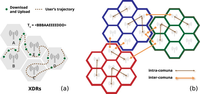
Mobile phone operators collect several different streams of mobile phones interaction with the cellular network for billing and operational purposes. Among them are the eXtended Detail Records (XDRs), a mixture of human- and device-driven event, triggered either by explicitly requesting an HTTP address or automatically downloading content from the Internet (e.g., emails) every 15 minutes and at certain traffic thresholds. Formally, an XDR is a tuple (u, t, A, k), in which there is only one tower A involved, u is the caller’s identifier, t is a timestamp of when the record is created, and k is the amount of downloaded information (Fig. 1a). Rather than capturing trips, we are interested in detecting any “movement”, i.e., any transition between two antennas. From an epidemiological point of view, transitions provide a useful indication of people’s displacements and hence useful information about the movements of the virus between areas within the same comuna or between two comunas. Even if an individual’s movement between two antennas may not be a trip from a semantic point of view, it denotes the movement of the virus between those two antennas anyway. To this purpose, from the XDRs of the individuals, we define two types of movement. Every time a user moves from one tower to another within the same comuna, they generate an intra-comuna movement. Every time the user moves from an tower to another in a different comuna, they generate an inter-comuna movement (Fig. 1b). For each day and comuna, we construct three indicators of mobility based on the intra- and inter-comuna movements:
IMint (Index of Internal Mobility), the number of intra-comuna movements for that day;
IMext (Index of External Mobility), the number of inter-comuna movements for that day;
IM = IMint + IMext (Index of Mobility).
Fig. 1.
(a) Illustrative example of eXtended Detail Records (XDRs) of a mobile phone user. The hexagons represent mobile phone towers and green dots the positions where the user starts a download/upload operation. The dotted line indicates the real movement of the user, from the left to the right. (b) Intra-comuna movements (black arrows) and inter-comuna movements (orange arrows). Hexagons of the same color indicate towers that fall in the same comuna.
All the three indices ranges in [0, ∞), where a value of 0 indicates no mobility at all. We normalize the three indices with respect to the number of users that reside in the comuna, estimated as the total number of unique mobile devices whose home tower falls in that comuna. Each device’s home tower is computed as the tower in which it has the highest number of XDRs during nighttime (between 7 pm and 7am, inclusive)021,56. The number of estimated resident users in the comunas is strongly correlated (R2 = 0.96, slope = 4.37, intercept = 298.30) with the official population of the comunas as per the official 2017 Chilean Census.
Data Records
The raw datasets were provided by Telefónica/Movistar Chile, a mobile phone company which possesses between 29–32% of the Chilean mobile phone market. Telefónica gathers data for billing purposes and for network maintenance purposes by persisting network events. Users are not allowed to “opt-out” of billing information, as stated in the terms and conditions below. They are, however, able to opt out of the use of personal data by calling a number or visiting the Telefónica website (see page 3, section 6) of Telefónica’s Terms and Conditions (see57 in Spanish). In this study, no personal data or information whatsoever is used in the creation of the dataset proposed here (in fact, it’s only the aggregated number of transitions between rtowe)s, without any individual information.
From the raw datasets we construct the three mobility indices described above. The datasets are released under the CC BY 4.0 License and are publicly available at58. Table 1 shows the structure of the dataset describing the mobility indices. Each record refers to a comuna in Chile and describes:
the official name of the region (region, type:string);
the identifier of the region as per the official 2017 Chilean Census (rid, type:string);
the official name of the comuna (comuna, type:string);
the identifier of the comuna as per the official 2017 Chilean Census (cid, type:string). All maps and their official identifiers can be downloaded from the National Statistics Office of Chile59;
the area of the comuna in km2 (area, type:float);
the values of IM, IMint and IMext for that day (type:float);
the day the IM, IMint and IMext values refer to (date, type:date).
Table 1.
Structure of the released dataset.
| region | rid | comuna | cid | area | IMint | IMext | IM | date |
|---|---|---|---|---|---|---|---|---|
| Los Ríos | 14 | Valdivia | 14101 | 1018.32 | 6.21 | 0.91 | 7.13 | 2020-02-26 |
| Los Ríos | 14 | Valdivia | 14101 | 1018.32 | 6.42 | 0.93 | 7.35 | 2020-02-27 |
| Los Ríos | 14 | Valdivia | 14101 | 1018.32 | 6.75 | 1.08 | 7.84 | 2020-02-28 |
| Los Ríos | 14 | Valdivia | 14101 | 1018.32 | 6.88 | 1.17 | 8.05 | 2020-02-29 |
| Los Ríos | 14 | Valdivia | 14101 | 1018.32 | 5.58 | 1.05 | 6.63 | 2020-03-01 |
Table 2 shows the structure of the quarantines dataset. Each record refers to a quarantine regulation and describes:
the identifier of the quarantine regulation (qid, type:integer);
the official name of the comuna (comuna, type:string);
the status of the quarantine, that can be either active or not active (status, type:string);
the coverage of the quarantine, that can be either partial, rural, or complete (coverage, type:string);
the date the quarantine started (start, type:date);
the date the quarantine ended, which is “ - ” if it is still active (end, type:date);
the identifier of the comuna as per the official 2017 Chilean Census (cid, type:string);
the area of the quarantine in m2 (area, type:float);
the perimeter of the quarantine (perimeter, type:float).
Table 2.
Structure of the quarantines dataset.
| qid | comuna | status | coverage | start | end | cid | area | perimeter |
|---|---|---|---|---|---|---|---|---|
| 4 | El Bosque | Active | whole | 2020-04-16 | — | 13105 | 2.06e7 | 1.87e4 |
| 26 | Quinta Normal | Active | whole | 2020-04-23 | — | 13126 | 1.70e7 | 2.12e4 |
| 38 | Cerrillos | Active | whole | 2020-05-05 | — | 13102 | 2.41e7 | 2.52e4 |
| 42 | Conchalí | Active | whole | 2020-05-08 | — | 13104 | 1.59e7 | 1.68e4 |
A limitation of all phone-records studies concerns the position of towers and the geographical area they “illuminate” or serve given their technical specifications. There may be towers that serve two neighboring comunas, for example, impacting our movement counts. However, two phenomena mitigate this problem: (i) comunas are generally large, and eventual borderline events are scarce given the 15-minute span; and (ii) telco companies do not record all antenna interactions by mobile devices, because storing all that information would be costly. In our case, an event (a phone record or XDR) is typically generated every y minutes and if and only if the device has crossed a threshold of x MegaBytes (MBs) of traffic (not revealed by the company as it is an industrial secret). A two-rule heuristic determines the quantities x and y. A “clock” triggers a rule every 15 minutes: if the user has reached x MBs at either 15, 30, or 45 minutes, the system appends a new XDR in the database. Some heavy users will use up the x MBs threshold at 15 minutes (if they are watching movies on the web, for instance), most at 30 minutes, and a few light users will reach the threshold at 45 minutes. There is also a fair share of frequency at other times. The second rule states that if the control plane of the mobile network notices some particular phone events, such as some antenna handovers, turning off the phone, or losing connection, then a record is created into the database at any time (irrespective of the megabytes used), making it possible to find events anywhere in-between the clock’s 15-minute triggers.
Technical Validation
In our analysis, we consider two periods: the pre-quarantine period, from March 9th to March 15th, 2020, and the quarantine period, from June 22nd to June 28th, 2020. Although we have two weeks before March 9th, the transition from February to March marks the start of the Fall school semester in Chile. In 2020, March 6th was the start of the semester, so we assume that the “business as usual” period would be best represented by the week of March 9th until March 15th. March 16th marked the start of NPIs in Chile, with the closure of schools, universities and large public gatherings. After that, on March 26th, there was a partial lockdown of seven comunas in the Metropolitan Region. By June 22–28, more than half of the population of the country was under quarantine, and mobility was at 40% reduction.
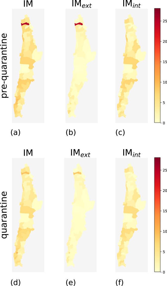
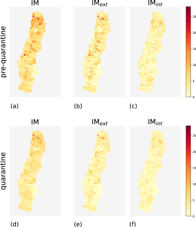
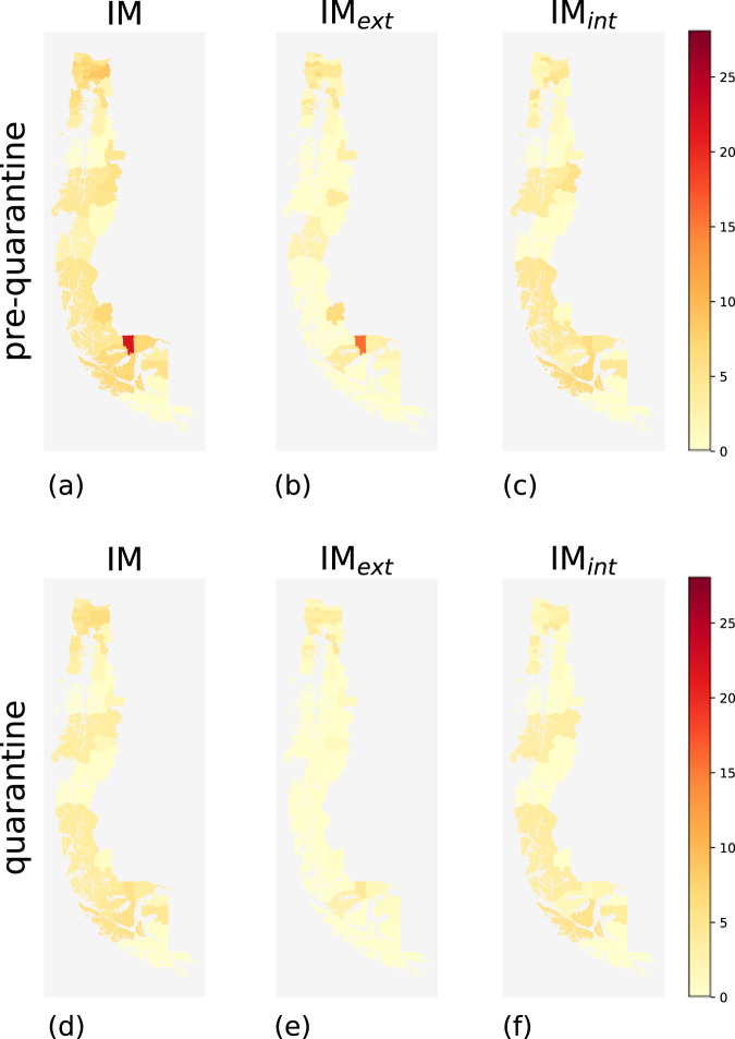
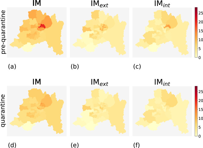
During the pre-quarantine period, comunas with high mobility indices and comunas with low mobility indices coexist. Geographically, high-mobility comunas are concentrated near urban areas such as the capital Santiago and, in general, in the center of the country (Figs. 2a, 3a, 4a, and 5a). The northern and southern parts of Chile have fewer high-mobility comunas. The comunas with the highest mobility registered during the pre-quarantine period are located in the regions of Metropolitana de Santiago, Arica y Parinacota, Valparaíso, Ñuble, and Magallanes (Table 3).
Fig. 2.
Choropleth maps of IM, IMint and IMext for the comunas in northern Chile for the pre-quarantine (first row) and the quarantine (second row) periods.
Fig. 3.
Choropleth maps of IM, IMint and IMext for the comunas in central Chile for the pre-quarantine (first row) and the quarantine (second row) periods.
Fig. 4.
Choropleth maps of IM, IMint, and IMext for the comunas in southern Chile for the pre-quarantine (first row) and the quarantine (second row) periods.
Fig. 5.
Choropleth maps of IM, IMint and IMext for the comunas in the metropolitan area of Santiago de Chile for the pre-quarantine (first row) and the quarantine (second row) periods.
Table 3.
Values of IM, IMext and IMint of the ten comunas with the highest IM computed between March 9th and March 15th, 2020.
| Pre-quarantine period | |||||
|---|---|---|---|---|---|
| Comuna | Region | IM | IMext | IMint | |
| 1 | Rinconada | Valparaíso | 30.37 | 27.96 | 2.42 |
| 2 | Providencia | Metropolitana de Santiago | 25.29 | 12.58 | 12.71 |
| 3 | Camarones | Arica y Parinacota | 24.62 | 23.77 | 0.85 |
| 4 | Ranquil | Ñuble | 23.87 | 18.33 | 5.54 |
| 5 | Laguna Blanca | Magallanes | 21.92 | 15.75 | 6.18 |
| 6 | Panquehue | Valparaíso | 20.93 | 19.02 | 1.90 |
| 7 | Vitacura | Metropolitana de Santiago | 20.40 | 10.54 | 9.86 |
| 8 | Las Condes | Metropolitana de Santiago | 20.22 | 7.79 | 12.42 |
| 9 | Zapallar | Valparaíso | 19.26 | 15.98 | 3.28 |
| 10 | Santiago | Metropolitana de Santiago | 17.44 | 6.97 | 10.48 |
As an example, Rinconada (Valparaíso region) has IM = 30.37, meaning that the number of movements within, to, or from that comuna is around 30 times higher than the estimated number of users that reside in Rinconada.
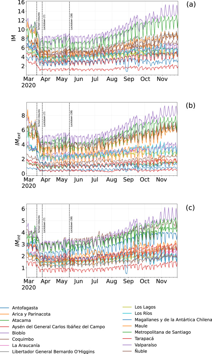
The top-ten comunas with the highest mobility indices change during the quarantine period, except for Rinconada in the region of Valparaíso (Table 4), mirroring the different degree of reduction in human mobility in the Chilean regions (Fig. 6). All regions show a reduction in all three mobility indices during the quarantine period, albeit with different intensities (Fig. 7). At the comuna level, high-mobility comunas are rare and clustered near the large urban areas located in central Chile (Figs. 2–5).
Table 4.
Values of IM, IMext and IMint of the ten comunas with the highest IM computed over the period from June 22nd and June 28th, 2020.
| Quarantine period | |||||
|---|---|---|---|---|---|
| Comuna | Region | IM | IMext | IMint | |
| 1 | Rinconada | Valparaíso | 22.44 | 21.09 | 1.35 |
| 2 | Zapallar | Valparaíso | 15.84 | 13.16 | 2.68 |
| 3 | Panquehue | Valparaíso | 13.30 | 11.13 | 2.17 |
| 4 | Coinco | Libertador Gen. B. O’Higgins | 13.20 | 12.36 | 0.84 |
| 5 | Andacollo | Coquimbo | 11.85 | 6.25 | 5.60 |
| 6 | Vitacura | Metropolitana de Santiago | 11.33 | 4.29 | 7.04 |
| 7 | Limache | Valparaíso | 11.25 | 5.41 | 5.84 |
| 8 | La Reina | Metropolitana de Santiago | 10.78 | 6.16 | 4.62 |
| 9 | Concón | Valparaíso | 10.75 | 4.69 | 6.06 |
| 10 | Villa Alegre | Maule | 10.67 | 8.67 | 1.99 |
As an example, Rinconada (Valparaíso region) has IM = 22.44, meaning that the number of movements within, to, or from that comuna is around 22 times higher than the estimated number of users that reside in Rinconada.
Fig. 6.
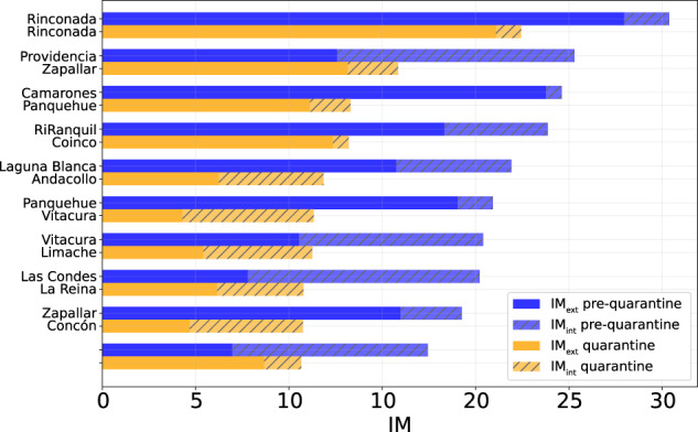
Values of IM, IMint, and IMext of the comunas in the top 10 ranking computed for the pre-quarantine and quarantine period. The coupled bars represent comunas corresponding to the same position in the rank.
Fig. 7.
Evolution of IM (a), IMext (b) and IMint (c) from March to September 2020 for the 16 regions in Chile. The curves are sorted in descending order respect to the relative index of mobility of the corresponding comuna. The vertical lines denote important dates regarding NPIs in Chile; the number in parentheses indicates the number of comunas subject to that restriction.
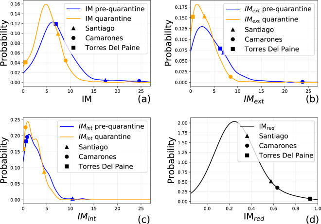
These results are supported by the distributions of the mobility indices of the two periods (Fig. 8). There is a clear shift towards the left of the distribution of the IM index (Fig. 8a): (i) the average IM during the quarantine period (5.16 ± 2.74) is 27.6% lower than the average IM during the pre-quarantine period (7.13 ± 4.15); (ii) the distribution of IM during the quarantine period is more skewed to the left, showing a decrease of the mobility in Chile during the selected days. Regarding IMint and IMext, we observe no net shift of the curve, but rather a flattening, suggesting that intra- and inter-comuna movements decreased during the quarantine (Fig. 8b,c).
Fig. 8.
Distributions of IM (a), IMext (b) and IMint (c) for the pre-quarantine (blue) and quarantine (orange) periods, with the average values of three comunas: Santiago, Camarones and Torres Del Paine. (d) Distribution of IMred for all the Chileans comunas.
We further analyze the reduction of the mobility defining IMred as the relative reduction of the IM index in the quarantine period with respect to the pre-quarantine period. The distribution of IMred shows that a large number of comunas have a reduced mobility, following Chilean government interventions, by an average of 25.37% ± 43.2 (Fig. 8d). However, comunas that were not in quarantine during the quarantine period do not reduce their mobility significantly (Fig. 9a).
Fig. 9.
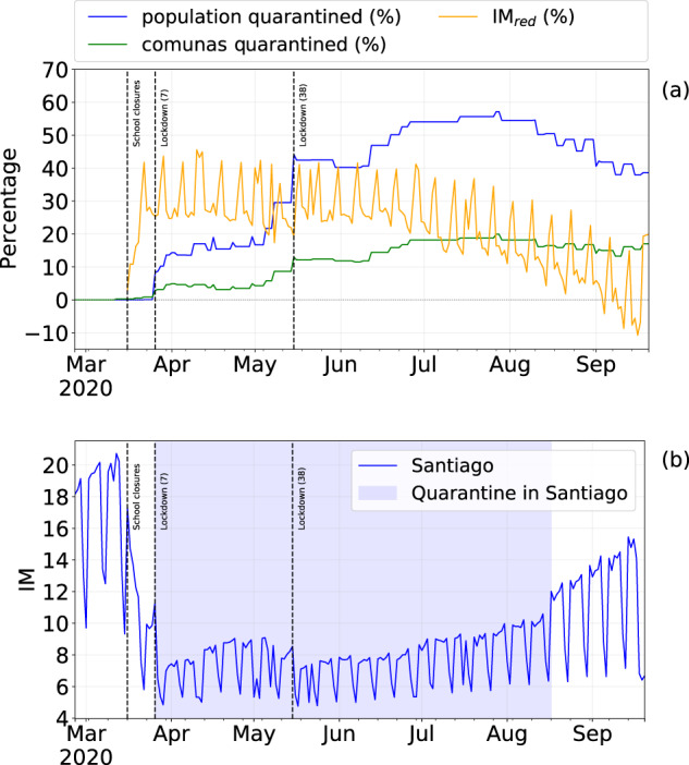
(a) Percentage of population under quarantine and the percentage of mobility reduction IMred from February 26th to September 20th, 2020. (b) Evolution of IM index in Santiago; the blue area denotes the quarantine period. The vertical lines denote important dates regarding NPIs in Chile; the number in parentheses indicates the number of comunas subject to that restriction.
The percentage of population that live in comunas where the authorities applied NPIs increases with time (Fig. 9a) reaches its peak (≈57%) in late July 2020. With the increase of the number of people under quarantine, IMred initially increases, but it slightly decreases over time even if both the number of individuals and the number of comunas under quarantine increase. This phenomenon suggests that mobility restrictions are more effective in the short-medium term and become less effective as time goes by, and it can be observed both at regional (Fig. 7) and comuna level (Fig. 9a,b).
Unfortunately, we do not have ground truth data to compare our data with because there are no official indices at the comuna level in Chile. However, other mobility reports do exist for the same area and period at the regional level (not comunas), such as Google Mobility Reports13. By aggregating our data at the regional level and comparing them with Google’s data, we find a strong Pearson correlation (r = 0.7), suggesting that our mobility index is reflecting mobility trends captured by other reliable data sources.
Limitations of our dataset
Mobile phone records are sparse and irregular in time, leading to gaps between the user’s actual trajectory and the trajectory that can be inferred from their digital trace15. Chen et al.60 propose an algorithm to reconstruct individual trajectories from CDRs by recovering the unspecified positions of each user. They revisit the seminal work of Gonzalez et al.23, in which the authors show that heavy-tails characterise the distributions of (charateristic) distances traveled by individuals, showing that CDRs preserve the mobility patterns observed in the reconstructed (denser) trajectories, though slightly underestimating long trips and overestimating short ones60. Considering that in our study we use XDRs, which are way denser than CDRs, we can assume that the mobility traces of individuals represented in our dataset do not differ significantly from the actual user’s trajectory.
Acknowledgements
Luca Pappalardo and Giuliano Cornacchia have been funded by 1) EU project SoBigData++ RI grant #871042, and 2) NextGenerationEU - National Recovery and Resilience Plan (Piano Nazionale di Ripresa e Resilienza, PNRR), project “SoBigData.it - Strengthening the Italian RI for Social Mining and Big Data Analytics”, prot. IR0000013, avviso n. 3264 on 28/12/2021. Leo Ferres and Loreto Bravo thank the funding and support of Telefónica R&D Chile and CISCO Chile. This research was supported by FONDECYT Grant N°1130902 to Loreto Bravo and FONDECYT Grant N°1221315 to Leo Ferres. We thank Daniele Fadda for his support on data visualization.
Author contributions
L.F., V.N. and L.B. developed and computed the mobility indices. L.P., L.F. and G.C. analyzed the data, made the plots and wrote the paper.
Code availability
The up-to-date data are available from the general repository of the Ministry of Science of Chile at: https://raw.githubusercontent.com/MinCiencia/Datos-COVID19/master/output/producto33/IndiceDeMovilidad.csv (IM indeces), and https://github.com/MinCiencia/Datos-COVID19/blob/master/output/producto29/Cuarentenas-Activas.csv (quarantines). The code to download the up-to-date data automatically and to reproduce the analysis in our paper is available at58.
Competing interests
The authors declare no competing interests.
Footnotes
Publisher’s note Springer Nature remains neutral with regard to jurisdictional claims in published maps and institutional affiliations.
References
- 1.Dong E, Du H, Gardner L. An interactive web-based dashboard to track covid-19 in real time. The Lancet infectious diseases. 2020;20:533–534. doi: 10.1016/S1473-3099(20)30120-1. [DOI] [PMC free article] [PubMed] [Google Scholar]
- 2.Lai S, et al. Effect of non-pharmaceutical interventions to contain COVID-19 in china. Nature. 2020;585:410–413. doi: 10.1038/s41586-020-2293-x. [DOI] [PMC free article] [PubMed] [Google Scholar]
- 3.Haushofer J, Metcalf CJE. Which interventions work best in a pandemic? Science. 2020;368:1063–1065. doi: 10.1126/science.abb6144. [DOI] [PubMed] [Google Scholar]
- 4.Gao S, Rao J, Kang Y, Liang Y, Kruse J. Mapping county-level mobility pattern changes in the united states in response to covid-19. SIGSpatial Special. 2020;12:16–26. doi: 10.1145/3404820.3404824. [DOI] [Google Scholar]
- 5.Chinazzi M, et al. The effect of travel restrictions on the spread of the 2019 novel coronavirus (covid-19) outbreak. Science. 2020;368:395–400. doi: 10.1126/science.aba9757. [DOI] [PMC free article] [PubMed] [Google Scholar]
- 6.Gatto M, et al. Spread and dynamics of the covid-19 epidemic in italy: Effects of emergency containment measures. Proceedings of the National Academy of Sciences. 2020;117:10484–10491. doi: 10.1073/pnas.2004978117. [DOI] [PMC free article] [PubMed] [Google Scholar]
- 7.Jia, J. S. et al. Population flow drives spatio-temporal distribution of covid-19 in china. Nature 1–5 (2020). [DOI] [PubMed]
- 8.Tian H, et al. An investigation of transmission control measures during the first 50 days of the covid-19 epidemic in china. Science. 2020;368:638–642. doi: 10.1126/science.abb6105. [DOI] [PMC free article] [PubMed] [Google Scholar]
- 9.Lucchini L, et al. Living in a pandemic: changes in mobility routines, social activity and adherence to COVID-19 protective measures. Scientific Reports. 2021;11:24452. doi: 10.1038/s41598-021-04139-1. [DOI] [PMC free article] [PubMed] [Google Scholar]
- 10.Gozzi N, et al. Estimating the effect of social inequalities on the mitigation of covid-19 across communities in santiago de chile. Nature communications. 2021;12:1–9. doi: 10.1038/s41467-021-22601-6. [DOI] [PMC free article] [PubMed] [Google Scholar]
- 11.Ferres, L. et al. Measuring levels of activity in a changing city. Tech. Rep., Institute of Data Science, Universidad del Desarrollo. https://datascience.udd.cl/covid_ids_tef_01.pdf (2020).
- 12.Buckee CO, et al. Aggregated mobility data could help fight covid-19. Science (New York, NY) 2020;368:145. doi: 10.1126/science.abb8021. [DOI] [PubMed] [Google Scholar]
- 13.Aktay, A. et al. Google covid-19 community mobility reports: Anonymization process description (version 1.1). https://arxiv.org/abs/2004.04145 (2020).
- 14.Luca, M., Barlacchi, G., Lepri, B. & Pappalardo, L. A survey on deep learning for human mobility. ACM Comput. Surv. 55. 10.1145/3485125 (2021).
- 15.Blondel VD, Decuyper A, Krings G. A survey of results on mobile phone datasets analysis. EPJ Data Science. 2015;4:10. doi: 10.1140/epjds/s13688-015-0046-0. [DOI] [Google Scholar]
- 16.Barbosa H, et al. Human mobility: Models and applications. Physics Reports. 2018;734:1–74. doi: 10.1016/j.physrep.2018.01.001. [DOI] [Google Scholar]
- 17.Andrienko G, et al. (so) big data and the transformation of the city. International Journal of Data Science and Analytics. 2021;11:311–340. doi: 10.1007/s41060-020-00207-3. [DOI] [Google Scholar]
- 18.Pappalardo L, Simini F, Barlacchi G, Pellungrini R. scikit-mobility: A Python Library for the Analysis, Generation, and Risk Assessment of Mobility Data. Journal of Statistical Software. 2022;103:1–38. doi: 10.18637/jss.v103.i04. [DOI] [Google Scholar]
- 19.Gabrielli, L., Furletti, B., Trasarti, R., Giannotti, F. & Pedreschi, D. City users’ classification with mobile phone data. 2015 IEEE International Conference on Big Data (Big Data) 1007–1012 (2015).
- 20.Deville P, et al. Dynamic population mapping using mobile phone data. Proceedings of the National Academy of Sciences. 2014;111:15888–15893. doi: 10.1073/pnas.1408439111. [DOI] [PMC free article] [PubMed] [Google Scholar]
- 21.Pappalardo L, Ferres L, Sacasa M, Cattuto C, Bravo L. Evaluation of home detection algorithms on mobile phone data using individual-level ground truth. EPJ Data Science. 2021;10:29. doi: 10.1140/epjds/s13688-021-00284-9. [DOI] [PMC free article] [PubMed] [Google Scholar]
- 22.Alessandretti L, Sapiezynski P, Sekara V, Lehmann S, Baronchelli A. Evidence for a conserved quantity in human mobility. Nature Human Behaviour. 2018;2:485–491. doi: 10.1038/s41562-018-0364-x. [DOI] [PubMed] [Google Scholar]
- 23.Gonzalez MC, Hidalgo CA, Barabasi A-L. Understanding individual human mobility patterns. nature. 2008;453:779–782. doi: 10.1038/nature06958. [DOI] [PubMed] [Google Scholar]
- 24.Pappalardo, L. et al. Returners and explorers dichotomy in human mobility. Nature Communications6 (2015). [DOI] [PMC free article] [PubMed]
- 25.Song, C., Qu, Z., Blumm, N. & Barabási, A.-L. Limits of predictability in human mobility. Science 1018–1021 (2010). [DOI] [PubMed]
- 26.Pappalardo L, Simini F. Data-driven generation of spatio-temporal routines in human mobility. Data Mining and Knowledge Discovery. 2018;32:787–829. doi: 10.1007/s10618-017-0548-4. [DOI] [PMC free article] [PubMed] [Google Scholar]
- 27.Hankaew S, et al. Inferring and modeling migration flows using mobile phone network data. IEEE Access. 2019;7:164746–164758. doi: 10.1109/ACCESS.2019.2952911. [DOI] [Google Scholar]
- 28.Balzotti C, Bragagnini A, Briani M, Cristiani E. Understanding human mobility flows from aggregated mobile phone data. IFAC-PapersOnLine. 2018;51:25–30. doi: 10.1016/j.ifacol.2018.07.005. [DOI] [Google Scholar]
- 29.Bonnel P, Fekih M, Smoreda Z. Origin-destination estimation using mobile network probe data. Transportation Research Procedia. 2018;32:69–81. doi: 10.1016/j.trpro.2018.10.013. [DOI] [Google Scholar]
- 30.Simini F, Barlacchi G, Luca M, Pappalardo L. A Deep Gravity model for mobility flows generation. Nature Communications. 2021;12:6576. doi: 10.1038/s41467-021-26752-4. [DOI] [PMC free article] [PubMed] [Google Scholar]
- 31.Pappalardo L, et al. An analytical framework to nowcast well-being using mobile phone data. International Journal of Data Science and Analytics. 2016;2:75–92. doi: 10.1007/s41060-016-0013-2. [DOI] [Google Scholar]
- 32.Eagle N, Macy M, Claxton R. Network diversity and economic development. Science. 2010;328:1029–1031. doi: 10.1126/science.1186605. [DOI] [PubMed] [Google Scholar]
- 33.Frias-Martinez V, Virseda-Jerez J, Frias-Martinez E. On the relation between socio-economic status and physical mobility. Information Technology for Development. 2012;18:91–106. doi: 10.1080/02681102.2011.630312. [DOI] [Google Scholar]
- 34.Šćepanović S, Mishkovski I, Hui P, Nurminen JK, Ylä-Jääski A. Mobile phone call data as a regional socio-economic proxy indicator. PLoS ONE. 2015;10:e0124160. doi: 10.1371/journal.pone.0124160. [DOI] [PMC free article] [PubMed] [Google Scholar]
- 35.Mao H, Shuai X, Ahn Y-Y, Bollen J. Quantifying socio-economic indicators in developing countries from mobile phone communication data: applications to côte d’ivoire. EPJ Data Science. 2015;4:15. doi: 10.1140/epjds/s13688-015-0053-1. [DOI] [Google Scholar]
- 36.Voukelatou V, et al. Measuring objective and subjective well-being: dimensions and data sources. International Journal of Data Science and Analytics. 2021;11:279–309. doi: 10.1007/s41060-020-00224-2. [DOI] [Google Scholar]
- 37.de Montjoye Y-A, et al. On the privacy-conscientious use of mobile phone data. Nature Scientific Data. 2018;5:180286. doi: 10.1038/sdata.2018.286. [DOI] [PMC free article] [PubMed] [Google Scholar]
- 38.de Montjoye, Y.-A., Hidalgo, C. A., Verleysen, M. & Blondel, V. D. Unique in the crowd: The privacy bounds of human mobility. Scientific Reports3 (2013). [DOI] [PMC free article] [PubMed]
- 39.Pellungrini R, Pappalardo L, Pratesi F, Monreale A. A data mining approach to assess privacy risk in human mobility data. ACM Transactions on Intelligent Systems and Technologies. 2017;9:31:1–31:27. [Google Scholar]
- 40.Fiore M, et al. Privacy in trajectory micro-data publishing: a survey. Transactions on Data Privacy. 2020;13:91–149. [Google Scholar]
- 41.Oliver, N. et al. Mobile phone data for informing public health actions across the covid-19 pandemic life cycle. Science Advances6 (2020). [DOI] [PMC free article] [PubMed]
- 42.Finger F, et al. Mobile phone data highlights the role of mass gatherings in the spreading of cholera outbreaks. Proceedings of the National Academy of Sciences. 2016;113:6421–6426. doi: 10.1073/pnas.1522305113. [DOI] [PMC free article] [PubMed] [Google Scholar]
- 43.Tizzoni M, et al. On the use of human mobility proxies for modeling epidemics. PLoS Comput Biol. 2014;10:e1003716. doi: 10.1371/journal.pcbi.1003716. [DOI] [PMC free article] [PubMed] [Google Scholar]
- 44.Wesolowski A, et al. Quantifying the impact of human mobility on malaria. Science. 2012;338:267–270. doi: 10.1126/science.1223467. [DOI] [PMC free article] [PubMed] [Google Scholar]
- 45.Bengtsson L, et al. Using mobile phone data to predict the spatial spread of cholera. Scientific reports. 2015;5:8923. doi: 10.1038/srep08923. [DOI] [PMC free article] [PubMed] [Google Scholar]
- 46.Kang Y, et al. Multiscale dynamic human mobility flow dataset in the us during the covid-19 epidemic. Scientific Data. 2020;7:1–13. doi: 10.1038/s41597-020-00734-5. [DOI] [PMC free article] [PubMed] [Google Scholar]
- 47.Kraemer MUG, et al. The effect of human mobility and control measures on the covid-19 epidemic in china. Science. 2020;368:493–497. doi: 10.1126/science.abb4218. [DOI] [PMC free article] [PubMed] [Google Scholar]
- 48.Pullano G, Valdano E, Scarpa N, Rubrichi S, Colizza V. Evaluating the effect of demographic factors, socioeconomic factors, and risk aversion on mobility during the covid-19 epidemic in france under lockdown: a population-based study. The Lancet Digital Health. 2020;2:e638–e649. doi: 10.1016/S2589-7500(20)30243-0. [DOI] [PMC free article] [PubMed] [Google Scholar]
- 49.Badr HS, et al. Association between mobility patterns and covid-19 transmission in the usa: a mathematical modelling study. The Lancet Infectious Diseases. 2020;20:1247–1254. doi: 10.1016/S1473-3099(20)30553-3. [DOI] [PMC free article] [PubMed] [Google Scholar]
- 50.Bakker, M., Berke, A., Groh, M., Pentland, A. & Moro, E. Effect of social distancing measures in the new york city metropolitan area. Tech. Rep., Massachusetts Institute of Technology (2020).
- 51.Han SY, Tsou M-H, Knaap E, Rey S, Cao G. How do cities flow in an emergency? tracing human mobility patterns during a natural disaster with big data and geospatial data science. Urban Science. 2019;3:51. doi: 10.3390/urbansci3020051. [DOI] [Google Scholar]
- 52.Xu Y, González MC. Collective benefits in traffic during mega events via the use of information technologies. Journal of The Royal Society Interface. 2017;14:20161041. doi: 10.1098/rsif.2016.1041. [DOI] [PMC free article] [PubMed] [Google Scholar]
- 53.Zhang, J., Zheng, Y. & Qi, D. Deep spatio-temporal residual networks for citywide crowd flows prediction. In Thirty-First AAAI Conference on Artificial Intelligence (2017).
- 54.Xie P, et al. Urban flow prediction from spatiotemporal data using machine learning: A survey. Information Fusion. 2020;59:1–12. doi: 10.1016/j.inffus.2020.01.002. [DOI] [Google Scholar]
- 55.Yin, X. et al. A Comprehensive Survey on Traffic Prediction. Preprint at https://arxiv.org/abs/2004.08555 (2020).
- 56.Vanhoof M, Reis F, Ploetz T, Smoreda Z. Assessing the quality of home detection from mobile phone data for official statistics. Journal of Official Statistics. 2018;34:935–960. doi: 10.2478/jos-2018-0046. [DOI] [Google Scholar]
- 57.Telefónica Chile. Condiciones contractuales del servicio telefónico movil https://ww2.movistar.cl/terminos-regulaciones/condiciones-comerciales-y-contractuales-movil/pdf/CondicionesContractualesTelefonicoMovil.pdf (2020).
- 58.Ferres L, Pappalardo L, Cornacchia G, Bravo L, Navarro-Aranguiz V. 2021. Mobility index for local quarantines in chile. figshare. [DOI]
- 59.Instituto Nacional de Estadísticas de Chile. Censo 2017 comuna: Población, viviendas por área y densidad https://geoine-ine-chile.opendata.arcgis.com/search?tags=Capas%20Base (2020).
- 60.Chen, G., Viana, A., Fiore, M. & Sarraute, C. Complete trajectory reconstruction from sparse mobile phone data. EPJ Data Science8 (2019).
Associated Data
This section collects any data citations, data availability statements, or supplementary materials included in this article.
Data Citations
- Ferres L, Pappalardo L, Cornacchia G, Bravo L, Navarro-Aranguiz V. 2021. Mobility index for local quarantines in chile. figshare. [DOI]
Data Availability Statement
The up-to-date data are available from the general repository of the Ministry of Science of Chile at: https://raw.githubusercontent.com/MinCiencia/Datos-COVID19/master/output/producto33/IndiceDeMovilidad.csv (IM indeces), and https://github.com/MinCiencia/Datos-COVID19/blob/master/output/producto29/Cuarentenas-Activas.csv (quarantines). The code to download the up-to-date data automatically and to reproduce the analysis in our paper is available at58.


