

Abstract
The Natural Pothole Dataset within River Environments is an extensive collection of 3992 high-resolution images [1] documenting various natural potholes located in riverine settings. Each image has been rigorously annotated utilizing the YOLO (You Only Look Once) object detection framework, which ensures precise bounding box coordinates and accurate class labels for identified potholes. The annotations are provided in XML format, facilitating seamless integration with machine learning algorithms and computer vision applications. This dataset is particularly valuable for researchers and professionals in Geomorphology, Hydrology, River Science, Machine Learning, Environmental Science, and geospatial analysis, offering a robust foundation for tasks such as pothole detection, classification, and predictive modelling. By focusing exclusively on the natural occurrence of potholes, the dataset captures the diversity in shapes, sizes, and environmental contexts, thereby enriching the study and understanding of riverine geomorphological processes.
Keywords: Natural potholes, Abrasion, Cavitation, Geomorphology, Hydrology, Machine learning
Specifications Table
| Subject | Geomorphology, Hydrology, River Science, Machine Learning, Environmental Science, and geospatial analysis |
| Specific subject area | Geomorphology & Environmental Science |
| Data format | JPG, XML, TXT |
| Type of data | Image, Annotation, Bounding Box Coordinate |
| Data collection | The dataset comprises 3992 images of natural Potholes gathered from the Kukadi river from village Nighoj region in Taluka-Parner, District Ahmednagar, Maharashtra, India. The Specific segments of the Kukadi River were chosen based on the prevalence of natural potholes. Geomorphologists and hydrologists conducted preliminary surveys to identify areas with a high density of potholes, ensuring a representative sampling of various pothole shapes, sizes, and environmental contexts. Images were captured during winter seasons to account for variations in water levels, flow rates, and visibility, providing a comprehensive view of the pothole characteristics. The captured images were saved in JPG format and resized to a resolution of 1440×1080 pixels in Landscape mode. In portrait mode has a resolution 801×1080. Each image has been annotated using the YOLO object detection framework, ensuring precise bounding box coordinates and accurate class labels for the identified potholes. These annotations are provided in Extensible Markup Language (XML) format. |
| Data source location | Nighoje, Taluka- Parner, Dist -Ahmednagar Pin - 414,306. State : Maharashtra, Country- India. Latitude- 18.932820149273443, Longitude- 74.26306612892922, |
| Data accessibility | Repository name: Natural Pothole Dataset within River Environments Data identification number: .17632/8rrpmgwbtm.1 Direct URL to data: https://data.mendeley.com/datasets/8rrpmgwbtm/1 |
1. Value of the Data
-
•
To the best of our knowledge, this dataset is the first publicly accessible collection of natural potholes.
-
•
The dataset comprises 3992 high-resolution images [1], serving as a valuable resource for studying natural potholes in river environment. It provides an extensive range of examples that capture the diversity in shapes, sizes, and environmental contexts of natural potholes. This broad coverage makes the dataset highly valuable for in-depth geomorphological studies.
-
•
This dataset also includes annotations with YOLO-based bounding boxes and class labels in XML format, as well as coordinates in TXT file format, for every natural pothole image.
-
•
Researchers and practitioners can utilize this dataset for various tasks such as natural pothole detection, classification, and predictive modeling, promoting advancements in both scientific research and practical applications.
-
•
This dataset's focus on natural potholes within a river environment enables detailed examination of fluvial processes and geomorphological phenomena. It aids in understanding the formation, evolution, and distribution of natural potholes, contributing to broader environmental and geomorphological knowledge. Researchers can utilize the dataset to study natural pothole formation dynamics and examine the influence of environmental conditions on natural pothole development.
-
•
By providing a well-annotated and diverse set of images, the dataset serves as a valuable resource for training and validating machine learning models. It enables the development of more accurate and robust models for natural pothole detection and analysis, contributing to improved environmental monitoring and management strategies.
The Natural Pothole Dataset is a valuable resource that significantly contributes to the understanding and analysis of natural potholes in river environments, supporting a wide range of scientific and practical applications.
2. Background
Natural potholes, also known as rock-cut basins, are intriguing geomorphological features typically found in river environments. These formations are created through the erosive action of water and sediment, resulting in distinctive, often circular depressions in the bedrock of riverbeds. Studying natural potholes provides valuable insights into fluvial processes, sediment transport, and the dynamic interactions between water flow and geological substrates.
The Natural Pothole Dataset within River Environments was developed to facilitate comprehensive research into these unique geological features. The dataset focuses on the Kukadi River, a significant tributary of the Ghod River in western India, known for its abundant natural potholes. High-resolution images were captured at various locations along the river, encompassing a wide range of natural pothole shapes, sizes, and environmental contexts.
A notable aspect of this dataset is its meticulous annotation using the object detection framework. This state-of-the-art machine learning technique ensures precise bounding box coordinates and accurate class labels for each identified natural pothole, making the dataset highly reliable for automated analysis. The annotations are provided in XML format, ensuring compatibility with numerous machine learning and computer vision pipelines.
This dataset serves multiple disciplines, including Geomorphology, Hydrology, River Science, Environmental Science, Machine Learning, and geospatial analysis. It offers a robust foundation for tasks such as natural pothole detection, classification, and predictive modeling. By providing a well-documented and diverse set of images, the dataset supports the development of advanced analytical tools and models, contributing to enhanced understanding and management of riverine environments.
Fig. 1 shows the formation process of natural potholes. It begins with an existing rock surface in a riverbed or a location subjected to flowing water. This surface can be composed of various rock types, including granite, sandstone, or limestone. Flowing water, particularly in rivers and streams, exerts hydraulic forces on the rock surface. This flow can be turbulent or laminar, depending on the river's velocity and volume of water. Sediment particles such as sand, gravel, and small rocks are carried by the moving water. These particles act as abrasives, colliding with the rock surface repeatedly.
Fig. 1.

Formation Process of Natural Pothole.
As the water flows, it creates vortices and eddies that concentrate the sediment particles in specific areas. The continuous impact and grinding action of these particles gradually erode the rock, leading to the initial depressions. Cavitation occurs when rapid changes in water pressure cause the formation and collapse of vapor bubbles. These micro-explosions produce high-energy impacts on the rock surface.
The collapse of these bubbles against the rock accelerates the erosion process, further deepening and enlarging the depressions formed by abrasion. ver time, the combination of abrasion and cavitation deepens the initial depressions into well-defined natural potholes.
These natural potholes often develop a cylindrical or hemispherical shape due to the rotational movement of water and sediments within them. The swirling motion enhances the abrasive action and ensures uniform erosion of the rock. Nature potholes can reach significant depths and diameters, sometimes several meters across.
In some cases, adjacent natural potholes can merge to form larger, irregularly shaped depressions through continued erosion and rock removal. The rate and extent of natural pothole formation are influenced by various environmental factors, including the volume and velocity of water flow, the type and hardness of the rock, the sediment load, and seasonal variations in river dynamics.In summary, the Natural Pothole Dataset within River Environments is an invaluable resource that bridges the gap between traditional geomorphological studies and modern data-driven approaches. It enables researchers and practitioners to explore the complexities of riverine natural potholes with unprecedented detail and accuracy, fostering advancements in both scientific research and practical applications.
3. Data Description
The Natural Pothole Dataset within River Environments comprises a collection of 3992 high-resolution images [1] capturing various instances of natural potholes found in the Kukadi River. This dataset is annotated to facilitate a wide range of research and application purposes (Table 1).
Table 1.
Data Description of Natural Pothole dataset.
| Image Data | |
| Total Natural pothole Images | 3992 |
| Resolution | |
| Landscape mode | 1440×1080 |
| Portrait Mode | 801×1080 |
| Content | Each image depicts natural potholes in the river environment, showcasing their diverse shapes, sizes, and contexts. The images were taken from different angles and elevations to provide a comprehensive view of the natural potholes. |
| Annotations | |
| Annotation Framework | YOLO (You Only Look Once) object detection |
| Bounding Boxes | Precise coordinates for bounding boxes around each identified natural pothole |
| Class Labels | Accurate labels indicating the presence of natural potholes |
| Format | XML |
| Structure | |
| XML File | Each image file is paired with an XML annotation file. The structure of the XML files follows a standardized format for easy integration with machine learning algorithms and computer vision applications. |
| key elements in the XML files | <filename>: Name of the image file <size>: Dimensions of the image (width, height, depth) <object>: For each identified natural pothole, this element includes: <name>: Class label (e.g., " natural pothole") <bndbox>: Bounding box coordinates (xmin, ymin, xmax, ymax) |
| Image Capturing Equipment Information | |
| Make and Model | Samsung Galaxy F 23 5G (SM-E236B) Android Mobile |
| Rear Primary Camera | Equipped with a 50-megapixel (f/1.8) lens |
| Camera Sensor | Sony IMX 582 1/2″ sensor |
| Image Capturing Condition | |
| Season | Winter |
| Time | Morning, afternoon |
The dataset's images are of high quality, with a resolution set at 72 dots per inch (dpi), ensuring clear and detailed visual representation of the natural potholes [[2], [3], [4], [5], [6], [7], [8], [9]].
Fig. 2 Shows the folder arrangement in dataset for Natural Pothole dataset.
Fig. 2.

Arrangement of the Natural Pothole dataset folders.
The Natural Pothole Dataset is organized into three main folders to support a variety of applications and analyses. The first folder, Natural Pothole Images, houses all the high-resolution images of natural potholes in JPG format, offering a rich visual resource for researchers. The second folder, PASCAL VOC, contains the dataset formatted according to the PASCAL Visual Object Classes (VOC) standard, a renowned benchmark in computer vision for tasks like object detection, classification, and segmentation. This folder includes annotations in XML format, ensuring compatibility with many existing computer vision frameworks. The third folder, YOLO, features text files that specify the coordinates for the bounding boxes around the natural pothole areas. This format is designed specifically for use with the YOLO object detection framework, allowing for precise and efficient pothole detection in images. Together, these folders provide a comprehensive and versatile dataset, suitable for a wide range of scientific and engineering applications.
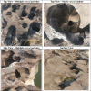
The Table 2 shows sample images of natural potholes.
Table 2.
Sample images of natural pothole in river environment.
 |
4. Experimental Design, Materials and Methods
4.1. Experimental design
This dataset is processed through three steps: Image acquisition, Image Annotation. The framework of the proposed pipeline is illustrated in Fig. 3. The processing steps of the Natural Pothole image dataset are described as follows:
Fig. 3.

Key steps in Image Acquisition Process.
Image Acquisition Process:
The image acquisition process for the Natural Pothole Dataset within River Environments was planned and executed to ensure the collection of high-quality, representative images of natural potholes in the Kukadi River in India. The process involved several key steps, described as follows:
Initially, geomorphologists and hydrologists conducted preliminary surveys to identify segments of the river with a high density of natural potholes. These sites were selected based on the diversity of natural pothole shapes, sizes, and surrounding environmental contexts to ensure a comprehensive dataset (Fig. 4).
Fig. 4.

GPS Location of natural potholes within River Environment.
The images were captured during winter season. The reason to select winter season as there is less water in natural potholes and better visibility of natural potholes. Photographs were taken under various lighting conditions, such as morning, midday, and evening, to minimize shadows and reflections, ensuring clear visibility of natural pothole features.
Images were taken from multiple angles and elevations, including top-down and oblique perspectives, to document the three-dimensional structure of the natural potholes. Both close-up shots, focusing on individual natural potholes, and wide shots, showing the broader river environment, were captured to provide a comprehensive view of the natural potholes and their contexts.
Collected images underwent an initial on-site review to ensure clarity and proper coverage. Post-processing adjustments were made to brightness, contrast, and resolution as needed, ensuring uniform quality across the dataset. Annotations were cross-verified by experts to ensure accuracy and consistency in the identification and labelling of natural potholes.
Throughout the image acquisition process, efforts were made to minimize environmental impact. No significant alterations were made to the natural river environment, and necessary permissions were obtained from local authorities to ensure compliance with regulatory and ethical guidelines.
Each image was documented with relevant metadata. Images and their corresponding annotations were securely stored and backed up to prevent data loss and ensure long-term accessibility.
This thorough and systematic image acquisition process ensured that the Natural Pothole Dataset within River Environments is of high quality, diverse, and representative of the natural conditions of the River. This robustness makes the dataset a valuable resource for researchers and practitioners in various fields related to geomorphology, hydrology, and environmental science.
Image Annotation Process: The image annotation process for the Natural Pothole Dataset within River Environments was designed to ensure precise and accurate identification of natural potholes in the collected images. Initially, the images underwent preprocessing, including adjustments to brightness, contrast, and sharpness, to enhance the visibility of the natural potholes. This preprocessing also involved standardizing the image sizes and formats to maintain consistency across the dataset, making the annotation process more efficient.
For the annotation itself, the YOLO (You Only Look Once) object detection framework was selected due to its efficiency and accuracy. Annotators manually drew bounding boxes around each visible natural pothole in the images, ensuring the boxes were tightly fitted to the edges of the natural potholes for precise localization. Each bounding box was assigned a class label, specifically “natural pothole,” to distinguish it from other objects or features in the river environment.
To maintain high annotation quality, a rigorous multi-step verification process was implemented. Annotators initially reviewed their work to ensure correctness. Subsequently, experts in geomorphology and computer vision reviewed a subset of annotated images to verify the accuracy of the bounding boxes and the appropriateness of the class labels. Any identified errors or inconsistencies were corrected, and the images were re-annotated if necessary, ensuring a high standard of annotation accuracy.
The annotations were stored in XML format, compatible with various machine learning and computer vision frameworks. Each XML file included the filename of the corresponding image, the image dimensions, and detailed object information for each annotated natural pothole, including the class label and bounding box coordinates. This structured format facilitated easy integration with machine learning models.
An example XML structure include elements like the filename, image size, and object details, such as the class label “Natural Potholes” and the coordinates of the bounding box. These annotated data were then used to train machine learning models, providing high-quality training data that enhanced the models' detection and classification capabilities.
The annotation process is designed to be ongoing, allowing for the continuous addition of new images and annotations to the dataset. By making the dataset publicly available, the researchers invite contributions and improvements from the broader scientific community, fostering collaborative enhancement. This thorough and precise annotation process ensures that the Natural Pothole Dataset is robust, accurate, and highly valuable for various applications in machine learning, computer vision, and environmental research.
Classification through Annotation: he annotated files are instrumental in the image classification process. During model training, these annotations serve as the ground truth, allowing the machine learning algorithm to learn the visual characteristics of natural potholes and how to distinguish them from other elements in the images. The precise bounding boxes and class labels enable the model to understand both the appearance and the spatial location of natural potholes. The annotated files in the Natural Pothole Dataset within River Environments are crucial for the image classification process, as they provide the necessary data for training and validating machine learning models. Each image in the dataset is annotated using the YOLO (You Only Look Once) object detection framework, which ensures high accuracy in identifying and localizing natural potholes.
4.2. Steps to annotate natural potholes images using YOLO
Image Preparation: Prepare a dataset of Natural pothole images for annotation.
Labeling Tool: Use a labeling tool LabelImg to manually draw bounding boxes around objects and assign class labels. The tool will save annotations in YOLO format, typically as text files with the same name as the images. Here we defined the area with bounding box which cover natural pothole area. Fig. 5 desribe annotation file using YOLO
Fig. 5.

Description of annotation file using YOLO.
YOLO Annotation Format:
Each line in the annotation file corresponds to one bounding box.
Format: class_id x_center y_center width height
class_id: Index of the class label. Here all image are relate with only one class that is Natural Potholes. Which is mentioned with Class ID 0.
x_center and y_center: Coordinates of the bounding box center, normalized to the width and height of the Natural pothole image (values between 0 and 1).
width and height: Width and height of the bounding box, normalized to the image dimensions of natural potholes.
Training YOLO: Use the annotated dataset to train the YOLO model. The model learns to predict bounding box coordinates and class labels for objects in images.
Inference: Once trained, the YOLO model can be used to detect and annotate objects in new images, outputting bounding box coordinates and class labels.
By following these steps, YOLO effectively uses coordinates to annotate natural pothole images, making it a powerful tool for object detection tasks (Fig. 6).
Fig. 6.

XML File for Natural Pothole Image.
The annotation in XML format
The provided annotation follows a format commonly used in object detection datasets, where objects within an image are labeled with bounding boxes to identify their locations. This specific annotation is in a format similar to Pascal VOC, which is often used for training object detection models like YOLO (You Only Look Once). Here's a detailed breakdown of the annotation:
-
1.
<annotation>: This is the root element that contains all the information about the annotated image.
-
2.
<folder>Natural Potholes</folder>: Indicates the folder where the image is stored. In this case, the folder is named "Natural Potholes".
-
3.
<filename>NaturalPotholes1.jpg</filename>: The name of the image file.
-
4.
<path>C:\Users\User\Desktop\Natural Potholes\Leaf Rot\NaturalPotholes1.jpg</path>: The full path to the image file on the user's system.
-
5.<source>:
-
○<database>Unknown</database>: Indicates the source of the image, which is unknown in this case.
-
○
-
6.<size>:
-
○<width>1440</width>: The width of the image in pixels.
-
○<height>1080</height>: The height of the image in pixels.
-
○<depth>3</depth>: The number of color channels in the image (3 for RGB).
-
○
-
7.
<segmented>0</segmented>: Indicates whether the image is segmented (0 means no segmentation).
-
8.<object>: This element contains details about the object detected in the image.
-
○<name>Natural Potholes</name>: The label or class name of the object.
-
○<pose>Unspecified</pose>: The pose of the object (not specified here).
-
○<truncated>0</truncated>: Indicates whether the object is truncated (0 means no truncation).
-
○<difficult>0</difficult>: Indicates whether the object is difficult to detect (0 means not difficult).
-
○<bndbox>: The bounding box coordinates for the object.
-
■<xmin>421</xmin>: The x-coordinate of the top-left corner of the bounding box.
-
■<ymin>230</ymin>: The y-coordinate of the top-left corner of the bounding box.
-
■<xmax>648</xmax>: The x-coordinate of the bottom-right corner of the bounding box.
-
■<ymax>385</ymax>: The y-coordinate of the bottom-right corner of the bounding box.
-
■
-
○
Fig. 7 shows the timeline for the collection of Natural Pothole dataset.
Fig. 7.

Timeline for the collection of Natural Pothole dataset.
The robust and detailed annotations in the Natural Pothole Dataset provide a solid foundation for developing effective machine learning models for natural pothole detection and classification. These models can then be applied to a variety of tasks, including environmental monitoring, geomorphological studies, and river management, demonstrating the practical utility of the dataset.
4.3. Materials or specification of image acquisition system
The cameras that were utilized to collect the data and the details of the images that were taken:
Samsung Galaxy F 23 5G Android Mobile
-
•
Make and Model: Samsung Galaxy F 23 5G (SM-E236B) Android Mobile.
-
•
Rear Primary Camera: Equipped with a 50-megapixel (f/1.8) lens.
-
•
Camera Sensor: Utilizes the Sony IMX 582 1/2” sensor.
-
•
Battery: Comes with a 5000 mAh battery.
To capture high-quality images for the dataset, we used the back cameras of the Samsung F23 5G, known for their exceptional resolution. We followed standard image acquisition procedures and converted the captured images to resolution of 1440×1080 pixels in Landscape mode and 801×1080 pixel in portrait mode in JPG format. IrfanView software is used to convert images to the specified resolution and for naming the images.
4.4. Methods
The investigations were carried out by hydrologists and geomorphologists to pinpoint regions that were abundant in naturally occurring natural potholes. To provide thorough coverage, high-resolution mobile cameras were used to take pictures from a variety of perspectives and altitudes. The photographs were captured in winter with good lighting conditions to accommodate for variations in the surrounding area. To improve image quality and standardize formats, preprocessing processes were carried out, such as brightness, contrast, and sharpness changes. The annotation process used the YOLO object recognition framework, with annotators hand drawing bounding boxes and class labels around each natural pothole. An extensive verification process with expert evaluations made sure that the annotations were accurate. To acquire data, visits were made to diverse households in Nighoj, Taluka-Parner, District-Ahmednagar, state Maharashtra, India.
4.5. Evaluation framework
A comprehensive evaluation is essential to determine the dataset's effectiveness in training accurate and reliable models for natural pothole detection. We incorporate key metrics such as accuracy, precision, recall, and the F1-score to provide a holistic understanding of the models' capabilities. Utilizing a dataset of natural pothole images, we employed the VGG16, ResNet50, and EfficientNetV2B3 architectures, which are renowned for their proficiency in image recognition tasks. Initially, the model performance was limited, with VGG16 achieving 36 % accuracy, ResNet50 achieving 8 % accuracy, and EfficientNetV2B3 achieving 7 % accuracy. However, after training, substantial improvements were observed: VGG16 achieved an accuracy of 95 %, ResNet50 achieved 90 % accuracy, and EfficientNetV2B3 achieved 89 % accuracy (Table 3, Table 4).
Table 3.
Accuracy values for Natural potholes detection model.
| Model | Accuracy Before Training | Accuracy after training on our dataset |
|---|---|---|
| VGG16 | 36 % | 95 % |
| ResNet50 | 08 % | 90 % |
| EfficientNetV2B3 | 07 % | 89 % |
Table 4.
Average performace values on machine learning models using 5 fold cross validation technique.
| Model | Precision | Recall | F1 Score |
|---|---|---|---|
| VGG16 | 93.94 % | 94.74 % | 94.84 % |
| ResNet50 | 89.29 % | 89.78 % | 89.68 % |
| EfficientNetV2B3 | 88.82 % | 88.64 % | 88.54 % |
4.6. Dataset applications
The Natural Pothole Dataset offers numerous exciting applications in machine learning. One key application is automated pothole detection. By training models like Convolutional Neural Networks (CNNs) and using object detection frameworks such as YOLO we can achieve high-accuracy identification of potholes in images. This automation greatly enhances environmental monitoring and geological surveys by providing real-time detection capabilities. Additionally, advanced machine learning models like YOLO, VGG16, ResNet50, and EfficientNet can utilize the dataset for precise image segmentation and object detection tasks. These models can not only detect potholes but also accurately delineate their boundaries, which is crucial for detailed geological mapping and analysis. The dataset also facilitates the development of predictive models that forecast pothole occurrence and growth based on environmental variables and historical data. By analysing patterns and trends within the dataset, machine learning algorithms can predict future pothole formations, aiding proactive environmental management and planning. Real-time detection systems are another promising application. Deploying machine learning models on edge devices, such as single-board computers equipped with AI kits, enables immediate pothole detection and analysis in field studies, significantly improving the efficiency of environmental monitoring. The dataset is also a valuable resource for educational and research applications. It supports academic research and training in machine learning, geology, and environmental science, fostering innovation and development in these fields. Overall, the Natural Pothole Dataset opens up a range of machine learning applications that advance our understanding and management of natural potholes, contributing to more effective environmental monitoring, geological analysis.
Limitations
The dataset may be constrained by the spatial and temporal scope of data collection, potentially failing to capture all variations and anomalies in natural pothole formation across different river systems and over longer time periods.
Ethics Statement
Our study does not involve studies with animals or humans. Therefore, we confirm that our research strictly adheres to the guidelines for authors provided by Data in Brief terms of ethical considerations.
CRediT Author Statement
Rohini Jadhav: Conceptualization, Supervision, Writing – review & editing. Sandip Thite: Conceptualization, Writing – review & editing Shital Pawar: Conceptualization, Writing – review & editing. Kailas Patil: Methodology, Data curation, Writing – original draft. Prawit Chumchu: Conceptualization,Writing – review & editing.
Acknowledgements
We are grateful to Kasetsart University Sriracha Campus, Thailand and Vishwakarma University,
Pune for their support and provision of necessary resources during this research endeavour. We are thankful to Mr. Bhavin Baldota for his support in training the dataset model.
Declaration of Competing Interest
The authors declare that they have no known competing financial interests or personal relationships that could have appeared to influence the work reported in this paper.
Contributor Information
Kailas Patil, Email: kailas.patil@vupune.ac.in, kailas@eng.src.ku.ac.th.
Prawit Chumchu, Email: prawit@eng.src.ku.ac.th.
Data Availability
Natural Pothole Dataset within River Environments (Original data) (Mendeley Data).
References
- 1.S. Thite, K. Patil (2024), Natural pothole dataset within river environments (Version 1) [Dataset], 2024 Mendeley Data, doi: 10.17632/8rrpmgwbtm.1Y.
- 2.Thite S., Suryawanshi Y., Patil K., Chumchu P. Coconut (Cocos nucifera) tree disease dataset: a dataset for disease detection and classification for machine learning applications. Data Br. 2023;51 doi: 10.1016/j.dib.2023.109690. [DOI] [PMC free article] [PubMed] [Google Scholar]
- 3.Chumchu P., Patil K. Dataset of cannabis seeds for machine learning applications. Data Br. 2023;47 doi: 10.1016/j.dib.2023.109257. [DOI] [PMC free article] [PubMed] [Google Scholar]
- 4.Jadhav R., Suryawanshi Y., Bedmutha Y., Patil K., Chumchu P. Mint leaves: dried,fresh, and spoiled dataset for condition analysis and machine learning applications. Data Br. 2023;51 doi: 10.1016/j.dib.2023.109717. [DOI] [PMC free article] [PubMed] [Google Scholar]
- 5.Meshram V., Patil K. FruitNet: indian fruits image dataset with quality for machine learning applications. Data Br. 2022;40 doi: 10.1016/j.dib.2021.107686. 107686 ISSN 2352-3409. [DOI] [PMC free article] [PubMed] [Google Scholar]
- 6.Suryawanshi Y., Patil K., Chumchu P. VegNet: dataset of vegetable quality images for machine learning applications. Data Br. 2022;45:108657. doi: 10.1016/j.dib.2022.108657. [DOI] [PMC free article] [PubMed] [Google Scholar]
- 7.Huang M., Chen Y. Citrus dataset for image classification. Data Br. 2023;51 doi: 10.1016/j.dib.2023.109628. [DOI] [PMC free article] [PubMed] [Google Scholar]
- 8.Bhutad S., Patil K. Dataset of road surface images with seasons for machine learning applications. Data Br. 2022;42:108023. doi: 10.1016/j.dib.2022.108023. [DOI] [PMC free article] [PubMed] [Google Scholar]
- 9.Thite S., Patil K., Jadhav R., Suryawanshi Y., Chumchu P. Empowering agricultural research: a comprehensive custard apple (Annona squamosa) disease dataset for precise detection. Data Br. 2024;53:110078. doi: 10.1016/j.dib.2024.110078. [DOI] [PMC free article] [PubMed] [Google Scholar]
Associated Data
This section collects any data citations, data availability statements, or supplementary materials included in this article.
Data Availability Statement
Natural Pothole Dataset within River Environments (Original data) (Mendeley Data).