Abstract
This paper presents 2,000 years of settlement and land use within the Lake Pátzcuaro Basin, Mexico. Three findings challenge the conclusions of previous research. We show (i) that initial land degradation was caused by settlement, not by agriculture; (ii) that population density inversely correlates with erosion; and (iii) that land degradation was associated with European Conquest but not from the introduction of the Euro-agro suite. Instead, demographic collapse caused by European-introduced disease prevented human-generated landscapes from being maintained, resulting in widespread degradation. These findings support the use of indigenous landscape technology for modern conservation if past failings can be resolved.
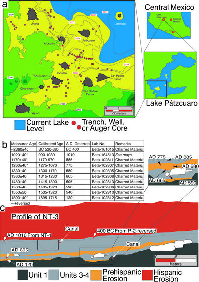
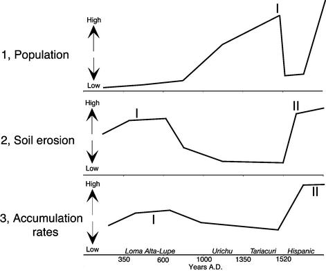
A “theoretical imperative” (1) for culture/ecosystem research [human ecodynamics (2–4)] is the identification of historical processes that have contributed to modern environments (5–12). Here we present 2,000 years of socionatural dynamics within the Lake Pátzcuaro Basin, Mexico, a prominent “Columbus Polemic” region (13–17) (Fig. 1a). Our three findings challenge the conclusions of previous research (Fig. 2). We show that initial land degradation was caused by settlement, not by agriculture; that population density inversely correlates with erosion; and that, whereas severe land degradation was associated with European Conquest, it was not the consequence of the introduction of European crops, animals, technologies, or land tenure (13, 14, 18). Rather, current widespread regional degradation was initiated from the disruption of a human-modified environment dependent on human labor lost to European-introduced disease (19).
Figure 1.
(a) Location of study area. Modern villages are shown in gray, exposure locations in red, and current lake level (≈2,032 m asl) in blue. Contour intervals in red are 1 m. (b) Radiocarbon information for the Lake Pátzcuaro Basin study. All dates were measured by accelerator MS and calibrated by using CALIB (http://depts.Washington.edu/qil/calib/). Because no limestone or volcanic springs are found within the basin, hard water error is not a factor. (c) Profile of Nocutzepo Trench 3 (NT-3) showing location of accelerator MS determinations in relation to the lithostratigraphic units identified in this study (modified from ref. 46).
Figure 2.
Summary of the long-term impact of human settlement on the terrestrial environment of the Lake Pátzcuaro Basin. (1) Lake Basin population density through time based both on area occupied and total estimated population (19, 50, 51). Population grows steadily during the Urichu phase (A.D. 900/1000–1350) with a peak population (I) during the Tariacuri phase (A.D. 1350–1520) associated with the Tarascan Empire. (2) Soil erosion showing two sedimentation peaks. The first (I) occurs in two episodes between A.D. 665–775 associated with the construction of ceremonial centers on the lower slopes of the Lake Basin. The second (II) is associated with European Conquest and the abandonment of the Precolumbian anthropogenic environment, exacerbated by the introduction of the Euro-agro ecosystem and high rainfall. (3) An idealized plot of sedimentation based on mineral magnetic analysis (ref. 19; see Supporting Text), accumulation rates (Fig. 5), and the source of parent material for colluvium on the lake bed (see Supporting Text). Two patterns are present: the first (I) represents erosion around Prehispanic settlements, principally Charahuén and Pareo; the second (II) is a landscape-wide pattern that predominates during the Hispanic period (modeled after ref. 31, figure 5 a and b; see ref. 72).
Evidence of land degradation in precontact Mexico is well established (see refs. 10 and 20–24). Although it falsifies the “pristine myth” of the “Columbus polemic” (22, 25–30), important questions remain regarding the impact of indigenous and Colonial land use in the Americas (10, 19, 23). A long history of human occupation and a well documented paleoecological record for the Lake Pátzcuaro Basin (Michoacán) have played pivotal roles in analyses of the impact of population, urbanism, and agriculture on the landscape (see refs. 10, 13, and 24). These analyses, however, have relied solely on environmental data. Since 1995, we have conducted both archaeological and geoarchaeological investigations in this region, and our results challenge many previous assumptions.
There are three central issues: (i) Although environmental degradation in Preclassic Mesoamerica (including the Lake Pátzcuaro Basin) is not in dispute (1, 13, 31, 32), its cause is largely unknown. Did it result from agricultural practices, settlement construction, or some other human activity?
(ii) The relationship between population density and soil erosion is also unclear. In the Americas, increasingly anthropogenic environments generated progressive improvements in crop yields (33–36). In such systems, degradation often results not from increased population density, but from a failure to maintain human-generated landscapes (33, 36–39).
Before Conquest, the Pátzcuaro Basin had become the epicenter of the Tarascan Empire. Its heavily engineered environment culminated centuries of small-scale modifications. Did increasing Tarascan settlement cause catastrophic soil erosion, as is commonly assumed (13), or was some other agency, heretofore unidentified, the primary cause of environmental degradation?
(iii) The abased landscapes of the Early Colonial period of the Mexican Highlands are often argued to be products of either population size or the introduction of European crops, animals, technologies, or land tenure (see review in refs. 24 and 40). Overlooked in this debate are the consequences of abandoning an intensive anthropomorphized landscape dependent on labor for stability. Did demographic collapse precipitate Early Colonial degradation? Our data from Lake Pátzcuaro provide means of resolving these vital issues.
Background
Lake Pátzcuaro occupies a small basin (928 km2) on the Central Mexican Altiplano [19° 36′ N 101° 39′ W 2,033–3,000 meters above sea level (m asl)] (Fig. 1a), with steeply sloped volcanic terrain (41, 42). Today the region receives between 900 and 1,250 mm of rainfall per year, supporting diverse vegetation communities (42) (fir and pine, 2,500–3,300 m asl, pine and oak; <2,500 m asl, agricultural crops, grasses, and secondary vegetation). Extensive paleoenvironmental research within the Pátzcuaro Basin provides a record of landscape change throughout the Holocene (13, 19, 41, 43–50) including three episodes of landscape instability: Unit II, 3,600–2,800 B.P.; Unit IV, 2,500–1,200 B.P.; Unit VI 850 B.P.–Present (13). It should be noted that the dating of Unit VI is problematic. Soil erosion during this phase may have been caused either by the dense population of the Tarascan Empire (13) or by Conquest-era changes [landscape abandonment, the Euro-agro suite, and high rainfall (19)]. Either may have caused carbonized material in soils and sediments to be released and deposited on the lake bed. If true, the resulting colluvium would contain carbon of mixed ages unsuitable for dating actual erosion events. We return to this issue below.
Prehistoric population estimates from recent archaeological research within the study area are provided in Table 1 (refs. 19 and 51; see also Table 2, which is published as supporting information on the PNAS web site, www.pnas.org). The methodology for this survey is published as Supporting Methods on the PNAS web site. The earliest occupation is indicated by maize pollen in lake cores [sometime between 1690 and 940 B.C. (43, 47, 49)]. The Late Preclassic period (<A.D. 350) is characterized by small village societies (52). During the Classic period (A.D. 400–900), ceremonial centers appear throughout the region (52–54). This pattern continues through the Early/Middle Postclassic (A.D. 900–1350) with increased population growth. From A.D. 1350 to 1520 the Basin served as the geopolitical core of the Tarascan Empire, with centralized economic, settlement, and political systems; urban centers; intensified landscapes (a discussion of Tarascan landscape intensification is available in Figs. 6–8, which are published as supporting information on the PNAS web site), and the largest population of the Prehispanic period (19, 51, 55, 56). During the Early Hispanic period (A.D. 1520–1650), the indigenous population was decimated by European-introduced disease along with conscription, emigration, widespread starvation, landscape abandonment, and large herds of pigs, all common by the early 1530s (50, 57, 58).
Table 1.
Summary of trends by archaeological phase
| Period (A.D.) | Hispanic (1520–1650)
|
Postclassic (1520–900/1000)
|
Classic (900/1000–350)
|
|||
|---|---|---|---|---|---|---|
| Early | Late | Middle | Early | Epiclassic | Middle | |
| Phases | Early | Tariacuri | Urichu | Urichu | Lupe | Loma Alta |
| Unit | 5 | 4 | 3 | 3 | 2–3 | 1–2 |
| Lake level | 2,040 | <2,033 | <2,033 | >2,035–<2,033 | >2,035 | >2,035 |
| Population | 1,560–3,560 | 13,087–7,155 | 7,806–4,087 | 1,706–925 | 1,018–581 | 393–543 |
| Settlement area, ha | 200 | 851.25 | 472.5 | 107.5 | 52.52 | 20 |
| Persons per km2 | 64 | 334–182 | 199–104 | 43–23 | 26–14 | 14–10 |
| Erosion | 4 | 2 | 2 | 2 | 4–5 | 5 |
Methods
A recent Pátzcuaro lake regression (≈10 m) has allowed us to conduct paleoenvironmental reconstruction below areas of Prehispanic occupation. When coupled with archaeological examination, our reconstruction allows a more precise identification of the source, timing, and duration of erosion. Over 88 exposures from the study area (250 km2), including agricultural wells, backhoe trenches, and auger cores, have been examined (Fig. 1a). These have been used to trace human-induced erosion from settlements onto the former lake bed. Mineral magnetic analysis was conducted on 1,000+ samples from 11 exposures to correlate them with the source-location of eroded material (ref. 19; the methodology and additional results of this analysis are shown in Fig. 9, which is published as supporting information on the PNAS web site). Deposition between A.D. 120 and 1010 was dated by 10 accelerator MS determinations (Fig. 1 b and c). Erosion after A.D. 1010 was identified by correlating precontact Urichu and Tariacuri phase settlements with associated lake-level and deposition unit (see description below).
Discussion
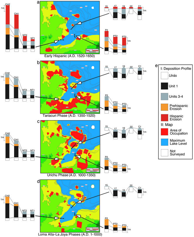
We identified five lithostratigraphic units with emergent (annually submerged/exposed), marsh, and deep-water environmental facies. All exposures are underlain with a thick stratum of diatomite that is uplifted on the edge of the lake basin (see Fig. 10, which is published as supporting information on the PNAS web site). This deposit dates lake formation (≈30,500 + 1,700−1,400 14C yr B.P.) (43, 49). The end of Unit 1 (A.D. 120) marks landscape stability and a high lake stage characterized by marsh sediment (shown in black, Figs. 1c and 3d). Magnetic values are generally low, except in exposures closest to the lake shore (Fig. 4; shown in black on Fig. 9).
Figure 3.
The coevolution of landscape and settlement by major archaeological phases. (a–d) Interplay of lake level, settlement, and lithostratigraphic unit that characterizes landscape development within the study region. The three catenas depicted (Insets) are, clockwise from top right: Copujo, Pareo, and Charahuén. (e I) Color indicating lithostratigraphic units. Central portion is a map of the study area; (II) color indicating settlement and lake level.
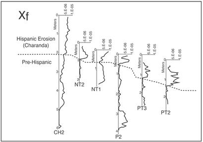
Figure 4.
Ferrimagnetic susceptibility (Xf) for key exposures used in this study below the Prehispanic sites of Charahuén and Pareo (Fig. 1a). Exposure locations shown in Fig. 3. Dashed line indicates the boundary between Hispanic/Prehispanic erosion that was used as one way of correlating exposures. Hispanic erosion is dominated by Charanda parent materials (see Supporting Text).
In two later episodes (A.D. 120–590, 665–775), fans of eroded material characterized by abrupt changes in color, texture, and structure (Unit 2, shown in orange, Figs. 1c and 3d) were deposited below the two largest Prehispanic occupations of these phases (Charahuén and Pareo, Fig. 1a). Magnetic values are high in exposures closest to the Prehispanic lake margin but progressively decrease as one moves onto the lake bed (shown in orange in Fig. 9). Away from Prehispanic settlement, the lake bed lacks colluvium and is associated with a second marsh (Unit 3, shown in gray, Figs. 1c, 3d, and 9). This early erosion event is the most severe of the Prehispanic period, with an accumulation rate (0.167–0.15 cm/year) (Fig. 5) similar to that of the Early Hispanic period. Importantly, this event is settlement-centered rather than landscape-wide and is associated with a low population density [Fig. 3d map, Table 1 (Loma Alta phase), 14–10 persons per km2; Lupe phase, 14–26 persons per km2].
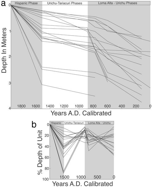
Figure 5.
(a) Accumulation rates plotted by years A.D. calibrated for 20 key exposures within the study area (after ref. 19). (b) Contribution of each unit to the total depth of the deposit plotted by years A.D. calibrated. This figure shows the same general temporal pattern but is highly variable in overall amount of deposition. For the Prehispanic era, the higher rates (steeper curve) are caused by proximity to settlements. For the Hispanic, higher rates are a function of proximity to shoreline. Asterisks in Fig. 1b indicate dates used to generate accumulation rates (modeled after figure 3.9 of ref. 73).
After A.D. 775, paleosol formation in the Unit 3 marsh (coupled with archaeological evidence of occupation as low as 2,033 m asl) indicates long-term lake regression, whereas marsh formation continues below 2,033 m asl. The occupation of newly exposed lake bed (>2,033 m asl) during this period indicates further lake regression (Fig. 3c map). Colluviation is reduced with low accumulation values (0.066–0.015 cm/year) (Fig. 5), demonstrating that early inhabitants stabilized the landscape during a period of population growth [Table 1 (Urichu phase), 104–199 persons per km2]. Additionally, this lake regression conforms to extant climatic data (13, 43, 59) and continues into the Tariacuri phase (A.D. 1350–1520).
During the Late Postclassic (A.D. 1350–1520), shoreline and island occupations are restricted to locations above 2,040 m asl, indicating a major lake transgression (Fig. 3b map, refs. 19 and 51). The burial of Unit 3 paleosols by a third marsh sediment (Unit 4, shown in gray, Figs. 1c and 3b) confirms this event, which conforms to the extant paleoenvironmental record (13, 43, 59). Colluviation remained low, with no increase in accumulation rates (Fig. 5) and low magnetic values (Fig. 4, shown in gray on Fig. 9), even though the lake basin holds the largest Prehispanic occupation in the sequence [Table 1 (Tariacuri phase), 182–334 persons per km2] with a heavily modified environment associated with the Tarascan Empire (19, 51, 55).
The Hispanic period (A.D. 1520 to present) marks a dramatic shift from the point-source erosion that characterized Prehispanic deposition to landscape-wide colluviation (Unit 5, shown in red, Figs. 1c and 3a), with upland materials (Charanda) dominating the sediment record on the lake bed. Unit 5 sediments are thick (20- to 100-cm) beds of sands to gravels, sorted and poorly sorted material, with an order of magnitude increase in magnetic values (Fig. 4, shown in red on Fig. 9) and the highest accumulation rates in the sequence (0.90–0.071 cm/year) (Fig. 5). These represent the stripping of soils and the erosion of the volcanic parent material underlying the escarpment of the lake basin. Laminated sediments over paleosols in areas without marsh sediments indicate the highest transgression in the sequence. This high stage is recorded in the ethnohistoric record beginning at Conquest and lasts until A.D. 1750–1800 (8, 50).
To resolve the issues of mixed-age carbon in colluvial deposits, as noted earlier, we developed an alternative method of dating sedimentation after A.D. 1010. Historically the islands of Copujo and low-lying portions of Jarácuaro (Fig. 1a and Fig. 3 a–d, map) have either been connected to the piedmont (below ≈2,039 m asl) or submerged (above 2,041 m asl) via lake level increase caused by both climatic and tectonic activity (19, 48, 50). The high lake stage at Conquest (48, 50) had a dramatic effect on settlement, constricting lake-shore occupation to above 2,040 m asl. Indeed, rising lake levels steadily compressed habitable area during much of the Postclassic. Progressive restriction begins with the Urichu phase (Fig. 3c map) and culminates with the final precontact phase (Tariacuri, Fig. 3b map), at which time island occupation roughly became equal to postcontact settlement size. The latter corresponds to the final phase of sediment deposition (Unit 5 shown in red, Figs. 1c and 3a). These Unit 5 red clays overlie Tariacuri- phase ceramics in many locations. This discovery implies that Unit 5 deposition, representing lake basin-wide soil erosion, was initiated during the Early Hispanic period.
Conclusion
From this record, three conclusions can be drawn regarding human environmental impact within the Lake Pátzcuaro Basin (Fig. 1b). First, population centers, not agriculture, initiated land degradation within the study region. This is similar to other prehistoric societies (1, 60–62) and further falsifies the “pristine myth” of prehistoric indigenous American landscapes (22, 24, 27), but with the following caveat: early degradation was settlement-wide, not landscape-wide, a pattern that persisted throughout the Prehispanic period. This suggests human, rather than climatic (or other), causation.
Second, erosion episodes (A.D. 120–775, 1520–1960) occurred while the basin contained a low population density, but landscape stability (A.D. 776–1520) was maintained during a period of population growth, urbanism, and increasing environmental modification. This apparent enigma is attributable to the development of the humanized Pátzcuaro environment, which in the centuries leading up to Conquest became increasingly dependent on labor for stability. Indeed, a parallel process occurred in 16th century Spain. There, the expulsion of the Moors resulted in the abandonment of associated intensive landscape systems (3, 63). Similar patterns of degradation caused by catastrophic labor lost to disease have been documented for other parts of Europe as well (3, 60). Like the Aztecs (64) and the Classic period Maya (1), Pátzcuaro land managers were forced to moderate past environmental damage, but in doing so they created an environment increasingly susceptible to risk. The construction of large-scale terrace landscapes, which began in the Early Postclassic and was enabled by the growing population within the Pátzcuaro Basin, may have been initiated as an attempt to repair earlier land degradation.
Finally, the degradation of the present-day landscape is traceable directly to the first landscape-wide erosion that occurred during the Early Hispanic period. This landscape instability was caused by wholesale abandonment and was exacerbated by the introduction of the Euro-agro suite and high rainfall (19). In Michoacán, indigenous land practice, rooted in abundant labor, created an environment susceptible to degradation subsequent to demographic collapse. But Tarascan land managers could not have foreseen the profound, and in many respects unintended, costs of the Conquest of the Americas. Mid-19th century lumbering, followed by the political and economic instability of the Mexican revolution and Cristero counterrevolution (A.D. 1910–1940), only deepened the degradation already in process.
This study demonstrates that, similar to those in other societies (39, 60, 62, 65, 66), the prehistoric inhabitants of the Lake Pátzcuaro Basin were able to maintain environmental stability for centuries, but at the same time created a landscape susceptible to unforeseen risk, in this instance population collapse. This long-term stability demonstrates that the use of indigenous landscape practices may be appropriate for modern conservation (67–71) but only if (39) care is taken to resolve the causes and practices that led to past failures (31).
Supplementary Material
Acknowledgments
This research greatly benefited from discussions with the landscapes group in the Department of Anthropology at Arizona State University. We also thank C. Owen Lovejoy, Joyce Marcus, Charles Redman, Gary Feinman, T. Douglas Price, Charles Frederick, Arturo Chacón, William Denevan, and Arleyn Simon. We extend our appreciation to the residents of the Lake Pátzcuaro Basin who provided access to property, assistance, and much local knowledge. We gratefully acknowledge support from the National Science Foundation, the National Endowment for the Humanities, the Wenner–Gren Foundation, the National Geographic Foundation, Kent State University, Michigan State University, Arizona State University, and the University of Wisconsin–Madison. Analysis and preparation were supported by the Archaeological Research Institute at Arizona State University. Permits were provided by the Instituto Nacional de Antropología e Historia.
Abbreviation
- m asl
meters above sea level
Footnotes
See commentary on page 4366.
References
- 1.Dunning N P, Luzzadder-Beach S, Beach T, Jones J G, Scarborough V, Culbert T P. Ann Assoc Am Geogr. 2002;92:267–283. [Google Scholar]
- 2.Mcglade J. Antiquity. 1995;69:113–132. [Google Scholar]
- 3.van der Leeuw S E the ARCHAEOMEDES Research Team. The Archaeomedes Project: Understanding the Natural and Anthropogenic Causes of Land Degradation and Desertification in the Mediterranean Basin. Luxembourg: European Commission; 1998. pp. 357–358. [Google Scholar]
- 4.van der Leeuw S E. In: The Way the Wind Blows: Climate, History, and Human Action. McIntosh R, Tainter J, McIntosh S K, editors. New York: Columbia Univ. Press; 2000. pp. 357–383. [Google Scholar]
- 5.van der Leeuw S E, Redman C. Am Antiq. 2002;67:597–605. [Google Scholar]
- 6.Vitousek P M, Mooney H A, Lubchenco J, Melillo J M. Science. 1997;277:494–499. [Google Scholar]
- 7.Alverson K, Oldfield F. Q Sci Rev. 2000;19:3–7. [Google Scholar]
- 8.Fisher C T, Thurston T. Antiquity. 1999;73:630–631. [Google Scholar]
- 9.Klepis P, Turner B L, II. Land Use Pol. 2001;18:27–39. [Google Scholar]
- 10.Redman C. Human Impact on Ancient Environments. Tucson, AZ: Univ. of Arizona Press; 1999. [Google Scholar]
- 11.Redman C. PAGES Newslett. 2000;8:4–5. [Google Scholar]
- 12.Tainter J. In: The Way the Wind Blows: Climate, History, and Human Action. McIntosh R, Tainter J, McIntosh S K, editors. New York: Columbia Univ. Press; 2000. pp. 331–357. [Google Scholar]
- 13.O'Hara S L, Street-Perrot F A, Burt T P. Nature. 1993;362:48–51. [Google Scholar]
- 14.Butzer K W. Nature. 1993;362:15–17. [Google Scholar]
- 15. Pollard, H. P., Fisher, C. T. & Feinman, G. M. (1994) Anthropol. News 2–4, March 1994.
- 16. Denevan, W. (1994) Anthropol. News 15, February 1994.
- 17. O'Hara, S. L., Street-Perrot, F. A. & Burt, T. P. (1994) Anthropol. News 4, March 1994.
- 18.Endfield G, O'Hara S L. Ann Assoc Am Geogr. 1999;89:402–419. [Google Scholar]
- 19.Fisher C T. Ph.D. thesis. Madison, WI: Univ. of Wisconsin; 2000. [Google Scholar]
- 20.Spores R. Science. 1969;166:557–569. doi: 10.1126/science.166.3905.557. [DOI] [PubMed] [Google Scholar]
- 21.Deevey E S, Rice D S, Rice P M, Vaughan H, Brenner M, Flannery M S. Science. 1979;206:298–306. doi: 10.1126/science.206.4416.298. [DOI] [PubMed] [Google Scholar]
- 22.Denevan W M. Ann Assoc Am Geogr. 1992;82:369–386. [Google Scholar]
- 23.Butzer K W. J Field Archaeol. 1996;23:141–150. [Google Scholar]
- 24.Whitmore T M, Turner B L, II. Cultivated Landscapes of Middle America on the Eve of Conquest. Oxford: Oxford Univ. Press; 2001. [Google Scholar]
- 25.Butzer K W. In: The Making of the American Landscape. Conzen M P, editor. Boston: Unwin Hyman; 1990. pp. 27–50. [Google Scholar]
- 26.Butzer K W. Erkunde. 1991;45:205–219. [Google Scholar]
- 27.Butzer K W. Ann Assoc Am Geogr. 1992;82:345–369. [Google Scholar]
- 28.Turner B L, Gómez Sal A, González Bernáldez F, di Castri F, editors. Global Land-Use Change: A Perspective from the Columbian Encounter. Madrid: Consejo Superior de Investigaciones Científicas; 1995. [Google Scholar]
- 29.Sluyter A. Ann Assoc Am Geogr. 1999;89:377–401. [Google Scholar]
- 30.Krech S I. The Ecological Indian: Myth and History. New York: Norton; 1999. [Google Scholar]
- 31.Binford M, Brenner M, Whitmore T M, Higuera-Gundy A, Deevey E, Leyden B. Q Sci Rev. 1987;6:115–128. [Google Scholar]
- 32.Rice D S, Rice P M. Lat Am Res Rev. 1984;19:7–34. [Google Scholar]
- 33.Blaikie P M, Brookfield H C, II, editors. Land Degradation and Society. London: Methuen; 1987. [Google Scholar]
- 34.Kirch P V. The Wet and the Dry: Irrigation and Agricultural Intensification in Polynesia. Chicago: Univ. of Chicago Press; 1994. [Google Scholar]
- 35.Doolittle W. Ann Assoc Am Geogr. 1984;74:124–137. [Google Scholar]
- 36.Scarborough V. In: Environmental Disaster and the Archaeology of Human Response. Bawden G, editor. Santa Fe, NM: Univ. of New Mexico Press; 2000. pp. 195–212. [Google Scholar]
- 37.Donkin R A. Agricultural Terracing in the New World. Tucson, AZ: Univ. of Arizona Press; 1979. [Google Scholar]
- 38.Zimmerer K. World Dev. 1993;21:1659–1675. [Google Scholar]
- 39.Denevan W M. Cultivated Landscapes of Native Amazonia and the Andes. Oxford: Oxford Univ. Press; 2000. [Google Scholar]
- 40.Melville E G. A Plague of Sheep: Environmental Consequences of the Conquest of Mexico. Cambridge, U.K.: Cambridge Univ. Press; 1994. [Google Scholar]
- 41.Chacón A T. El Lago de Pátzcuaro, Michoacán, Mexico: Bosque Limnológico de un Lago Amenazado. Morelia, Mexico: Univ. Michoacana; 1993. [Google Scholar]
- 42.West R. Cultural Geography of the Modern Tarascan Area. Pub. No. 7, Washington, DC: Smithsonian Institute of Social Anthropology; 1948. [Google Scholar]
- 43.Bradbury P J. Palaeogeogr Palaeocl. 2000;163:69–95. [Google Scholar]
- 44.Bridgewater N, Heaton T, O'Hara S L. J Paleolimnol. 1999;22:383–397. [Google Scholar]
- 45.Deevey E S. T Conn Acad Sci. 1944;39:213–328. [Google Scholar]
- 46.Fisher C T, Pollard H P, Frederick C. Antiquity. 1999;73:642–649. [Google Scholar]
- 47.Hutchinson G E, Patrick R, Deevey E S. Geol Soc Am Bull. 1956;67:1491–1504. [Google Scholar]
- 48.O'Hara S L. Geogr J. 1993;159:51–62. [Google Scholar]
- 49.Watts W A, Bradbury P J. Q Res. 1982;17:56–70. [Google Scholar]
- 50.Gorenstein S, Pollard H P. The Tarascan Civilization: A Late Prehispanic Cultural System. Nashville, TN: Vanderbilt Univ. Press; 1983. [Google Scholar]
- 51.Pollard H P. In: The Postclassic Mesoamerican World. Smith M E, Berdan F F, editors. Salt Lake City: Univ. of Utah Press; 2003. pp. 227–237. [Google Scholar]
- 52.Pollard H P. J Archaeol Res. 1997;5:345–384. [Google Scholar]
- 53.Pollard H P. In: Greater Mesoamerica: The Archaeology of West and Northwest Mexico. Gorenstein S, Foster M S, editors. Salt Lake City, UT: Univ. of Utah Press; 2000. pp. 59–71. [Google Scholar]
- 54.Pollard H P, Cahue L. Latin Am Antiq. 1999;10:259–281. [Google Scholar]
- 55.Pollard H P, Gorenstein S. Science. 1980;209:274–277. doi: 10.1126/science.209.4453.274. [DOI] [PubMed] [Google Scholar]
- 56.Pollard H P. Taríacuri′s Legacy: The Prehispanic Tarascan State. Norman, OK: Univ. of Oklahoma Press; 1993. [Google Scholar]
- 57.Warren J B. The Conquest of Michoacán: The Spanish Domination of The Tarascan Kingdom in Western Mexico, 1521–1530. Norman, OK: Univ. of Oklahoma Press; 1985. [Google Scholar]
- 58.Warren J B. La Administración de los Negocios de un Encomendero en Michoacán. Morelia, Mexico: SEP Michoacán/Univ. Michoacana; 1984. [Google Scholar]
- 59.Metcalfe S E, O'Hara S L, Caballero M, Davies S J. Q Sci Rev. 2000;19:699–721. [Google Scholar]
- 60.van Andel T, Zangger E, Demitrack A. J Field Archaeol. 1990;17:379–396. [Google Scholar]
- 61.Fall P L, Lines L, Falconer S. Ann Assoc Am Geogr. 1998;88:107–125. [Google Scholar]
- 62.Butzer K W. In: Civilizations of the Ancient Near East. Sasson J, Baines J, Beckman G, Rubinson K, editors. New York: Scribner; 1995. pp. 123–151. [Google Scholar]
- 63.Latorre J G, García-Latorre J, Sánchez-Picón A. Land Use Pol. 2001;18:53–64. [Google Scholar]
- 64.Williams B J. Ann Assoc Am Geogr. 1972;62:618–626. [Google Scholar]
- 65.Gilman A, Thornes J B. Land Use and Prehistory in South-East Spain. London: Allen & Unwin; 1985. [Google Scholar]
- 66.Runnels C. In: The Archaeology of Natural Disaster and Human Response. Bawden G, editor. Santa Fe, NM: Univ. of New Mexico Press; 2000. pp. 11–20. [Google Scholar]
- 67.Smith R T. In: Latin American Development: Geographical Perspectives. Preston D A, editor. New York: Wiley; 1987. pp. 34–69. [Google Scholar]
- 68.Toledo V M. In: Biodiversity: Culture, Conservation, and Ecodevelopment. Oldfield M, Alcorn J, editors. Boulder, CO: Westview; 1991. pp. 146–171. [Google Scholar]
- 69.Toledo V M, Álvarez-Icaza P, Ávila P. Plan Pátzcuaro 2000: Investigación Multidisciplinaria para el Desarrollo Sostenido. Yautepec, México: Fundación Friedrich Ebert; 1992. [Google Scholar]
- 70.Denevan W M. Adv Plant Pathol. 1995;11:21–43. [Google Scholar]
- 71.Erickson C. J Steward Anthropol Soc. 1992;20:1–16. [Google Scholar]
- 72.Rice D S. In: Lowland Maya Civilization in the Eighth Century A. D. Sabloff J A, Henderson J S, editors. Washington, DC: Dumbarton Oaks; 1993. pp. 11–63. [Google Scholar]
- 73.Brown A G. Alluvial Geoarchaeology: Floodplain Archaeology and Environmental Change. Cambridge, U.K.: Cambridge Univ Press; 1997. [Google Scholar]
Associated Data
This section collects any data citations, data availability statements, or supplementary materials included in this article.


