

Abstract
Intensive mechanized agriculture in the Brazilian Amazon grew by >3.6 million hectares (ha) during 2001–2004. Whether this cropland expansion resulted from intensified use of land previously cleared for cattle ranching or new deforestation has not been quantified and has major implications for future deforestation dynamics, carbon fluxes, forest fragmentation, and other ecosystem services. We combine deforestation maps, field surveys, and satellite-based information on vegetation phenology to characterize the fate of large (>25-ha) clearings as cropland, cattle pasture, or regrowing forest in the years after initial clearing in Mato Grosso, the Brazilian state with the highest deforestation rate and soybean production since 2001. Statewide, direct conversion of forest to cropland totaled >540,000 ha during 2001–2004, peaking at 23% of 2003 annual deforestation. Cropland deforestation averaged twice the size of clearings for pasture (mean sizes, 333 and 143 ha, respectively), and conversion occurred rapidly; >90% of clearings for cropland were planted in the first year after deforestation. Area deforested for cropland and mean annual soybean price in the year of forest clearing were directly correlated (R2 = 0.72), suggesting that deforestation rates could return to higher levels seen in 2003–2004 with a rebound of crop prices in international markets. Pasture remains the dominant land use after forest clearing in Mato Grosso, but the growing importance of larger and faster conversion of forest to cropland defines a new paradigm of forest loss in Amazonia and refutes the claim that agricultural intensification does not lead to new deforestation.
Keywords: agriculture, carbon, land use change, soybean
The “arc of deforestation” along the southern and eastern extent of the Brazilian Amazon is the most active land-use frontier in the world in terms of total forest loss (1) and intensity of fire activity (2). Historically, the dominant pattern of forest conversion has begun with small-scale exploration for timber or subsistence agriculture, followed by consolidation into large-scale cattle ranching operations or abandonment to secondary forest (3–5). Recent expansion of large-scale mechanized agriculture at the forest frontier has introduced a potential new pathway for forest loss, generating debate over the contribution of cropland expansion to current deforestation dynamics (5–9). In the nine states of the Brazilian Legal Amazon, mechanized agriculture increased by 36,000 km2,†† and deforestation totaled 93,700 km2‡‡ during 2001–2004. Recent gains in the area under cultivation and the productivity of locally adapted crop varieties have made Brazil a leading worldwide producer of grains such as soybeans; the agribusiness sector now accounts for more than one-third of Brazil’s gross national product (10).
The state of Mato Grosso alone accounted for 87% of the increase in cropland area and 40% of new deforestation during this period. Whether cropland expansion contributes directly to deforestation activity or occurs only through the intensified use of previously deforested areas has important consequences for ecosystem services (11), such as carbon storage, and future deforestation dynamics.
Amazon deforestation is Brazil’s largest source of CO2 emissions (12, 13). Carbon fluxes from deforestation are a function of the area of forest loss (14–16) and related forest disturbances, such as fire (17, 18) and logging (17, 19), variations in forest biomass across the basin (20), and land use or abandonment after forest clearing (3, 21). Land use after forest clearing remains a major source of uncertainty in the calculation of deforestation carbon fluxes because methods to assess deforestation trends in Amazonia have not followed individual clearings over time (4, 5, 22–28). The relative contributions of smallholder agriculture and large-scale cattle ranching to annual forest loss have been inferred from the size of deforestation events (5, 28), but no direct measurements have been available. Rapid growth of large-scale agriculture in Amazonia challenges the historic relationship between land use and clearing size.
We determine the fate of large deforestation events (>25 ha) during 2001–2004 in Mato Grosso State to provide satellite-based evidence for the relative contributions of cropland and pasture to increasing forest loss during this period (Fig. 1). Our approach combines satellite-derived deforestation data, vegetation phenology information from the Moderate Resolution Imaging Spectroradiometer (MODIS; ref. 29), and 2 years of field observations to establish the spatial and temporal patterns of land use after forest clearing.
Fig. 1.

Tropical deforestation for cropland agriculture in Mato Grosso state (2001–2004) is concentrated along the existing agricultural frontier. (Inset) Location of the study area subset within Mato Grosso state and the Amazon Basin.
Direct measurement of land use after deforestation is aided by MODIS, which began near-daily coverage of the entire Amazon Basin at 250-m to 1-km resolution in February 2000. The higher frequency of observations at moderate resolution improves the problem of persistent cloud cover in high-resolution satellite data for Amazonia (30) without sacrificing the ability to characterize land-cover changes in a fragmented forest landscape (31, 32). Time series of cloud-free composite images at 16-day intervals provide vegetation phenology information to identify different land-cover types from the unique patterns of vegetation greenness for cropland, pasture, and forest (33).
Results
The expansion of large-scale mechanized crop production contributed directly to 2001–2004 deforestation in Mato Grosso, adding to the existing pressure for forest loss from cattle ranching (Fig. 2Upper). We estimate that the area of tropical forest converted directly to large-scale crop production during 2001–2004 ranged from 785 to 2,150 km2 per year, peaking at 23% of 2003 annual deforestation in large clearings (>25 ha). Total cropland deforestation during this period exceeded 5,400 km2 of 33,200 km2 total deforestation in large clearings.
Fig. 2.

Trends in land use after 2001–2004 deforestation events >25 ha in Mato Grosso state, Brazil. (Upper) Summary of conversion dynamics by post-clearing land cover from satellite-based phenology information in the years after forest clearing. A preliminary estimate of 2005 deforestation is shown in gray (INPE PRODES). Inflation-adjusted prices per 60-kg sack of soybeans for the same period as the annual deforestation increment (September–August) are plotted on the right-hand axis in Brazilian Reais (R$).§§ (Lower) Fate of 2003 deforestation events by clearing size.
A shift in clearing dynamics occurred between 2002 and 2003 deforestation. The fraction of deforested area converted to cattle pasture decreased from 78% to 66%, whereas direct transitions to cropland increased from 13% to 23%, and the amount classified as not in production (9–10%) and in small clearings (15–17%) remained nearly constant. Favorable market conditions for agricultural exports, especially for soybeans, may have influenced the patterns in land use after deforestation. The mean annual soybean price during 2001–2004 was related to the amount of deforestation for cropland in Mato Grosso (R2 = 0.72).
For all years, the average clearing for cropland was more than twice the size of that for pasture (cropland mean = 333 ha, SD = 459 ha; pasture mean = 143 ha, SD = 267 ha; P < 0.0001). Deforestation for cropland accounted for 28% of the clearings >200 ha in 2003 compared with 6% of clearings <200 ha (Fig. 2 Lower). Smaller-size classes showed higher proportions of clearings not in production and slower conversions than larger deforestation-size classes.
The transition from forest to cropland occurred rapidly. Satellite-based vegetation phenology showed evidence of planting on >90% of new cropland areas during the year immediately after forest clearing. Conversions of forest to cattle pasture occurred more slowly than cropland transitions, such that 72–86% of pasture clearings were identified in the year after clearing, with the remainder requiring ≥2 years to develop a clear grass phenology component over the majority of the deforested area. Deforested area classified as not in production diminished in each subsequent year after deforestation, as forest clearings were gradually converted to pastures or cropland.
Cropland deforestation in Mato Grosso during 2001–2004 was concentrated within the Xingu river basin and near the existing centers of crop production (Sinop, Sorriso, Lucas do Rio Verde, and Nova Mutum) along the Cuiabá-Satarém highway (BR-163) in the central Mato Grosso State (Fig. 1). Deforestation for cattle pasture predominated in the northern and western portions of the state, and deforestation that retained or regrew forest cover did not show a specific spatial pattern.
The spatial distribution of large clearings during 2002–2005 shows the gradual advance of very large deforestation events into municipalities in northwest Mato Grosso (Fig. 3). Large clearings near the existing mechanized agricultural frontier in central and eastern Mato Grosso were highest in 2003 and 2004. In 2005, soybean prices fell by >25%, and municipalities in eastern Mato Grosso showed a decrease in large deforestation events, yet the central agricultural zone continued to exhibit a similar degree of large forest-clearing activity.
Fig. 3.

Spatial distribution of 2002–2005 deforestation events larger than 20 MODIS 250-m pixels (≈125 ha) for municipalities in Mato Grosso (32).
Discussion
Deforestation for large-scale cropland accounted for 17% of forest loss in large clearings during 2001–2004 in Mato Grosso, signaling a shift from historic uses of cattle ranching and smallholder agriculture. Growth in the number of large deforestation events (>25 ha) was responsible for annual increases in deforestation during the study period, and the relative contribution of cropland to large deforestation events was directly correlated with the price of soybeans in the year of forest clearing. Pasture remains the dominant land use after deforestation in Mato Grosso, but our results show a general trend of increasing cropland deforestation during 2001–2004 and a continuation of the pattern of large forest clearings in the central agricultural region in 2005. The rise in importance of deforestation for cropland signifies a new paradigm of Amazon deforestation defined by larger clearing sizes and faster rates of forest conversion than previous pathways of forest loss for pasture or smallholder agriculture. Our findings challenge previous assumptions about the fate of carbon after deforestation (3, 21), economic drivers of land-use change in Amazonia (4, 28, 34), and the possibility for land sparing through crop intensification (7, 35).
Implications for Future Deforestation Dynamics.
Mechanization of both forest clearing and crop production has encouraged simultaneous expansion and intensification of land use at the forest frontier. Although the growth of high-yield mechanized agriculture can be a land-sparing option compared with lower-yield methods (35), our results suggest that intensification of crop production in the Brazilian Amazon to meet global demand for feed crops (8, 9, 36) does not necessarily lead to local land sparing. Growing production of soybeans and other crops in Amazonia is also a function of expansion into nonforest cover types (33) and increased yields (ref. 7; Fig. 4). Conversion of planted pastures and natural grasslands accounted for 36% of new cropland area in Mato Grosso between 2001 and 2004, and an additional 30% of cropland expansion statewide replaced Cerrado savanna/woodland vegetation (33). Improved yields led to higher corn, rice, cotton, and sorghum production from Mato Grosso during 2000–2004, but soybean yield was 10% lower in 2004 than peak production in 2002 based on Brazilian Institute for Geography and Statistics (IBGE) Municipal Agricultural Production agricultural census data. Declining soybean yields may reflect expansion of cropland into less-productive sites, reductions in soil fertility, or lower harvests because of soybean rust (Phakopsora pachyrhizi; ref. 37) and other crop pathogens. Declining yields could be either an incentive or a disincentive to clear more land, but it is not possible to make this distinction from our analysis.
Fig. 4.

Relationship between cropland expansion and deforestation in Mato Grosso, Brazil, during 2001–2004. Estimates of forest conversion directly to cropland range from 4,670 (33) to 5,463 km2 (this study). Expansion of large-scale mechanized agriculture was estimated from annual land cover maps of Mato Grosso derived from MODIS-based phenology information; only transitions from forest, Cerrado, or pasture/grasslands to double-cropping systems are included in this estimate (33). Estimated cropland expansion from agricultural census data of total planted area is nearly two times the area derived from satellite data, because individual fields are counted separately for each crop rotation in the agricultural census.
Continued expansion of cropland production in Amazonia is possible. Large areas of the Amazon Basin are projected to have suitable soils, climate, and topography for large-scale mechanized agriculture (U.S. Department of Agriculture, www.fas.usda.gov/current2003.html, January 23, 2003; ref. 38), and many other regions of the world face a shortage of arable land for additional cropland expansion (39). Recent and planned future development of critical infrastructure, such as roadways and ports, is also intended to support ranching and farming operations by reducing the cost of transporting agricultural products to markets (6, 24). The new paradigm of Amazon deforestation makes farmers and ranchers flexible to future opportunities; once an area is cleared to bare soil for mechanized agriculture, it is highly fungible in terms of future land use. The rise and fall of profits for different crops, beef, plantation timber, and other resources will therefore determine future land use on both new deforestation and previously cleared areas.
Implications for Carbon Fluxes from Deforestation.
Deforestation dynamics in Mato Grosso during 2001–2004 highlight the need to understand land use after deforestation, rather than just the total area of forest loss, to characterize the timing and magnitude of carbon losses from forest clearing. Carbon losses per area deforested for cropland are potentially greater than other types of forest conversion because of the rapid and complete removal of above-ground biomass and woody roots to permit tractor planting, with little or no net carbon offset from subsequent crop production. Unlike previous estimates of carbon losses during conversion of forest to pasture (3, 21, 40, 41), decomposition may contribute very little to the total carbon lost during the conversion of forest to cropland, because trunks, stumps, and woody roots are completely combusted in multiple fire events during the clearing process. Stratifying land use after deforestation in terms of clearing size, biomass removal, and duration enables more accurate estimates of interannual variation in deforestation carbon fluxes from Amazonia than previously available.
Application to Deforestation Monitoring.
Characterizing the fate of individual clearings over time provides input for programs to reduce deforestation (5), projections of future deforestation (42), and efforts to identify priority areas for conservation (43). A similar approach as presented here that integrates moderate and high spatial resolution satellite data was established to identify deforestation events in the Brazilian Amazon in near-real time [Brazilian National Institute for Space Research (INPE) Program for the Estimation of Deforestation in the Brazilian Amazon (PRODES) and Program for Real-Time Detection of Deforestation (DETER)¶¶ programs]. Linking vegetation phenology data from MODIS with other types of change monitoring, such as logging (19), could be done to characterize the fate of other forest disturbances over time.
Our ability to fully explore the interannual variability in deforestation dynamics and place recent trends in the context of historic patterns of forest conversion is somewhat limited by the short duration of the MODIS time series. Results showing less regrowth after forest clearing than previous studies (15, 44), the short interval between forest clearing and production, and limited secondary land-use transitions after forest conversion (forest–pasture–cropland) merit further investigation with the growing MODIS data record. The approach is potentially applicable in other areas undergoing conversion to mechanized agriculture but could be limited by absence of high-resolution deforestation maps, clearing sizes too small for isolation of vegetation phenology information with MODIS 250-m resolution data, or land uses after forest clearing without distinct phenologies.
In summary, our findings refute the claim that new crop production in Amazonia is occurring only through intensified use of lands previously cleared for cattle ranching rather than adding a new pressure for forest loss (45, 46). The large clearings and complete removal of above-ground biomass indicate per area carbon emissions to the atmosphere greater than previous clearing for cattle ranching and fewer forest fragments on the landscape as habitat and suggest rapid loss of forest as infrastructure develops for large-scale agriculture. Growing linkages to global market demand for soybeans and other crops have reduced the remoteness of the forest frontier, and the potential exists for a return to higher deforestation in Mato Grosso as seen in 2003–2004 with a rebound of crop prices. Initiatives such as certification schemes for environmental best practices that apply market pressure to ranching and soybean production at the forest frontier (9) would augment existing efforts to reduce illegal deforestation through satellite-monitoring programs. Increasing incentives for intensified use of unproductive pastures or other existing cleared lands will also be essential to balance economic benefits from increasing crop production with ecosystem services from intact forest and Cerrado habitat.
Data and Methods
Remote-Sensing Analysis.
We combine field observations with satellite-based data on annual deforestation and vegetation phenology to classify the fate of new forest clearings >25 ha in Mato Grosso State, Brazil. Field data on the location and condition of deforested areas, pastures, and cropland were collected during June 2004, March 2005, and July 2005, and scaled from Global Positioning System point observations to polygon training data by digitizing feature boundaries on near-coincident Landsat Thematic Mapper (TM) data. Landsat TM data were provided by INPE before each field campaign and georeferenced to existing Landsat Enhanced Thematic Mapper Plus (ETM+) data provided by the Global Land Cover Facility with a spatial error of less than one pixel (30 m). We used PRODES digital results of the annual deforestation increment mapped using Landsat TM data from approximately August of 2001–2004 for the state of Mato Grosso to identify the location and size of new clearings and summarize total deforested area, limiting our analysis to new clearings >25 ha based on the moderate resolution (250 m) of the MODIS sensor (29, 31, 32). Estimates of 2005 deforestation in Mato Grosso State were generated from MODIS red reflectance data contained in the MODIS/Terra Vegetation Indices 16-day L3 Global product at 250-m resolution (MOD13Q1, version 4; ref. 47) and forest information from the PRODES 2004 deforestation analysis following methods outlined in ref. 33.
Before generating phenology metrics for land-cover classification, we implemented a two-stage method to remove cloud contamination in annual time series of normalized difference vegetation index (NDVI) and enhanced vegetation index (EVI) data from the MOD13Q1 product from 2000–2005 for three 10° × 10° spatial tiles (h12v10, h12v09, and h13v10). Clouds, cloud shadows, high aerosols, or other data artifacts were identified by using the Quality Assessment layer available with the MODIS data product and replaced with a predicted value by fitting the remaining high-quality data in each pixel’s time series with a cubic spline function. Second, the resulting annual time series were fit with zero to third-order harmonic functions to identify and eliminate any clouds not captured by the image-quality data layer (48). We derived 36 metrics from the cloud-free time series: NDVI and EVI minimum, maximum, mean, median, amplitude, and standard deviation for annual (yearn−1: day 273−yearn: day 288), wet season (yearn−1: day 273−yearn: day 112), and dry season (yearn: day 113–273) time periods. Harmonic equations provided three additional phenology amplitude and phase metrics for the classification process.
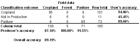
A decision-tree classifier was developed with training data from field observations in July 2004 and MODIS time series metrics from 2003-273 to 2004-288 (Fig. 5, which is published as supporting information on the PNAS web site). Validation of the classification was done by using field data from March and July 2005 and time series metrics from 2004-273 to 2005-288 (Table 1, which is published as supporting information on the PNAS web site). Following accurate classification of 2005 validation data (overall accuracy, 89%), the same classification rules were applied to each year of MODIS metrics. We define the fate of deforested areas as cropland, pasture, or not yet in production using the majority land-cover class within each deforestation polygon based on the improvement in classification accuracy for cropland and cattle pasture with this method. Deforestation classified as forest and degraded forest was combined into a single class, not in production, encompassing damaged forests that were never fully cleared (e.g., logged or burned forest), edge effects from adjacent forest cover, and regrowth.
Interpretation of Remote-Sensing Results.
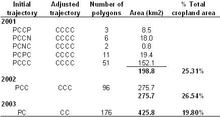
The classification was highly accurate in separating double-cropping systems and pasture. However, the annual phenological patterns of fallow agricultural cycles or single-crop rotations are similar to a pasture phenology and could be misclassified as such. To correct for these land-use patterns, we established a land-use trajectory from classification results for each year after deforestation to eliminate spurious pasture–cropland transitions in the first 2 years after deforestation (Table 2, which is published as supporting information on the PNAS web site). The largest contribution to estimated deforestation for cropland from the trajectory corrections was a single year of pasture classification followed by 1–3 years of cropland classification. Use of deforested lands as pasture for a single year is unlikely, given the high cost of fencing material (49). Trajectory-based modifications accounted for 20–27% of the total deforestation for cropland in 2001–2003. We report statistics and trends based on the corrected trajectories for deforestation in 2001–2003 and unadjusted results for 2004, because only one postclearing MODIS classification (2005) was available.
Soybean Price Data.
To estimate the influence of crop prices on deforestation, we adjusted the Fudaçao Getúlio Vargas Agroanalysis monthly price paid to soybean producers for inflation using a standard consumer price index (46), IBGE Extended National Consumer Price Index. Average annual prices were calculated from monthly data for the same period as PRODES deforestation calculations, September through August of each year, and August 2005 was the reference month for inflation adjustment.
Supplementary Material
Acknowledgments
We thank Jan Dempewolf, Carlos Klink, Greg Asner, and three reviewers for helpful comments on a previous version of this manuscript. This study was supported by grants from the National Aeronautics and Space Administration Large Scale Biosphere–Atmosphere Experiment in the Amazon (Projects LC-22 and LC-23), Land Use Land Cover Change, and Terrestrial Ecology Programs.
Abbreviations
- ha
hectares
- MODIS
Moderate Resolution Imaging Spectroradiometer
- PRODES
Program for the Estimation of Deforestation in the Brazilian Amazon
- INPE
Brazilian National Institute for Space Research
Footnotes
The authors declare no conflict of interest.
See Commentary on page 14261.
Total area planted in soybeans, corn, cotton, rice, sugarcane, and sorghum from municipality data on crop production (IBGE Municipal Agricultural Production, www.sidra.ibge.gov.br).
Annual deforestation increment from INPE PRODES, www.obt.inpe.br/prodes.
Data sources: Monthly price paid to soybean producers, Fudaçao Getúlio Vargas Agroanalysis; deflator, IBGE Extended National Consumer Price Index. Prices are shown per 60-kg sack of soybeans to maintain consistency with the common unit of soybean production.
INPE Detecção de Desmatamento em Tempo Real, or Program for Real-Time Detection of Deforestation, was started in 2003 to provide regular updates of new deforestation >25 ha in the Brazilian Amazon using data from MODIS sensors and CBERS-2, the Chinese–Brazilian Environmental Satellite. Data can be accessed at www.obt.inpe.br/deter.
References
- 1.Food and Agriculture Organization of the United Nations. Global Forest Resources Assessment 2005: Progress Towards Sustainable Forest Managment. Rome, Italy: Food and Agriculture Organization, United Nations; 2006. [Google Scholar]
- 2.Giglio L, Csiszar I, Justice CO. J Geophys Res. 2006;111 G02016. [Google Scholar]
- 3.Houghton RA, Skole DL, Nobre CA, Hackler JL, Lawrence KT, Chomentowski WH. Nature. 2000;403:301–304. doi: 10.1038/35002062. [DOI] [PubMed] [Google Scholar]
- 4.Lambin EF, Geist HJ. Environment. 2003;45:22–36. [Google Scholar]
- 5.Fearnside PM. Conserv Biol. 2005;19:680–688. [Google Scholar]
- 6.Fearnside PM. Environ Conserv. 2001;28:23–38. [Google Scholar]
- 7.Brown JC, Koeppe M, Coles B, Price KP. Ambio. 2005;34:462–469. [PubMed] [Google Scholar]
- 8.Naylor R, Steinfeld H, Falcon W, Galloway J, Smil V, Bradford E, Alder J, Mooney H. Science. 2005;310:1621–1622. doi: 10.1126/science.1117856. [DOI] [PubMed] [Google Scholar]
- 9.Nepstad DC, Stickler CM, Almeida OT. Conserv Biol. 2006 doi: 10.1111/j.1523-1739.2006.00510.x. in press. [DOI] [PubMed] [Google Scholar]
- 10.Empresa Brasileira de Pesquisa Agropecuária. Criação de Empregos Pelo Complexo Agroindustrial da Soja. Brasilia, Brazil: Ministry of Agriculture; 2004. [Google Scholar]
- 11.Mooney H, Cropper A, Reid W. Nature. 2005;434:561–562. doi: 10.1038/434561a. [DOI] [PubMed] [Google Scholar]
- 12.Ministério da Ciência e Tecnologia. Brazil’s Initial National Communication to the United Nations Framework Convention on Climate Change. Brasilia, Brazil: Ministry of Science and Technology; 2004. [Google Scholar]
- 13.Santilli M, Moutinho P, Schwartzman S, Nepstad DC, Curran LM, Nobre CA. Clim Change. 2005;71:267–276. [Google Scholar]
- 14.DeFries RS, Houghton RA, Hansen MC, Field CB, Skole DL, Townshend J. Proc Natl Acad Sci USA. 2002;99:14256–14261. doi: 10.1073/pnas.182560099. [DOI] [PMC free article] [PubMed] [Google Scholar]
- 15.Skole DL, Tucker C. Science. 1993;260:1905–1910. doi: 10.1126/science.260.5116.1905. [DOI] [PubMed] [Google Scholar]
- 16.Achard F, Eva HD, Stibig H-J, Mayaux P, Gellego J, Richards T, Malingreau J-P. Science. 2002;297:999–1002. doi: 10.1126/science.1070656. [DOI] [PubMed] [Google Scholar]
- 17.Nepstad DC, Veríssimo A, Alencar A, Nobre CA, Lima E, Lefebre P, Schlesinger P, Potter C, Moutinho P, Mendoza E, et al. Nature. 1999;398:505–508. [Google Scholar]
- 18.Cochrane MA. Nature. 2003;421:913–919. doi: 10.1038/nature01437. [DOI] [PubMed] [Google Scholar]
- 19.Asner GP, Knapp DE, Broadbent EN, Oliveira PJC, Keller M, Silva JN. Science. 2005;310:480–482. doi: 10.1126/science.1118051. [DOI] [PubMed] [Google Scholar]
- 20.Houghton RA, Lawrence KT, Hackler JL, Brown S. Glob Change Biol. 2001;7:731–746. [Google Scholar]
- 21.Hirsch AI, Little WS, Houghton RA, Scott NA, White JD. Glob Change Biol. 2004;10:908–924. [Google Scholar]
- 22.Hecht SB. Bioscience. 1993;43:687–695. [Google Scholar]
- 23.Pfaff ASP. J Env Econ Mgmt. 1999;37:26–43. [Google Scholar]
- 24.Nepstad DC, Carvalho GO, Barros AC, Alencar A, Capobianco JP, Bishop J, Moutinho P, Lefebre P, Silva UL, Prins E. For Ecol Manag. 2001;154:395–407. [Google Scholar]
- 25.Geist HJ, Lambin EF. Bioscience. 2002;52:143–150. [Google Scholar]
- 26.Cardille JA, Foley JA. Remote Sens Environ. 2003;87:551–562. [Google Scholar]
- 27.Chomitz KM, Thomas TS. Am J Agric Econ. 2003;85:1016–1028. [Google Scholar]
- 28.Margulis S. World Bank Working Paper No. 22: Causes of Deforestation of the Brazilian Amazon. Washington, DC: World Bank; 2004. [Google Scholar]
- 29.Justice CO, Vermote E, Townshend J, DeFries RS, Roy DP, Hall DK, Salomonson VV, Privette JL, Riggs G, Strahler A, et al. IEEE Trans Geosci Remote Sens. 1998;36:1228–1249. [Google Scholar]
- 30.Asner GP. Int J Remote Sens. 2001;22:3855–3862. [Google Scholar]
- 31.Anderson LO, Shimabukuro YE, DeFries RS, Morton DC. IEEE Geosci Remote Sens Lett. 2005;2:315–318. [Google Scholar]
- 32.Morton DC, DeFries RS, Shimabukuro YE, Anderson LO, del bon Espírito-Santo F, Hansen MC, Carroll M. Earth Interact. 2005;9:1–22. [Google Scholar]
- 33.Morton DC, DeFries RS, Shimabukuro YE. In: Cerrado Land Use and Conservation: Assessing Trade-Offs Between Human and Ecological Needs. Klink C, DeFries RS, Cavalcanti R, editors. Washington, DC: Conservation International; 2006. in press. [Google Scholar]
- 34.Kaimowitz D, Mertens B, Wunder S, Pacheco P. Hamburger Connection Fuels Amazon Destruction: Cattle Ranching and Deforestation in Brazil’s Amazon. Jakarta, Indonesia: Center for International Forestry Research; 2004. [Google Scholar]
- 35.Green RE, Cornell SJ, Scharlemann JPW, Balmford A. Science. 2005;307:550–555. doi: 10.1126/science.1106049. [DOI] [PubMed] [Google Scholar]
- 36.Kaimowitz D, Smith J. In: Agricultural Technologies and Tropical Deforestation. Angelsen A, Kaimowitz D, editors. Wallingford, UK: CABI Publishing; 2001. pp. 195–212. [Google Scholar]
- 37.Yorinori JT, Paiva WM, Frederick RD, Costamilan LM, Bertagnolli PF, Hartman GE, Godoy CV, Nunes J., Jr Plant Dis. 2005;89:675–677. doi: 10.1094/PD-89-0675. [DOI] [PubMed] [Google Scholar]
- 38.Jasinski EW, Morton DC, DeFries RS, Shimabukuro YE, Anderson LO, Hansen MC. Earth Interact. 2005;9:1–18. [Google Scholar]
- 39.Food and Agriculture Organization. World Agriculture: Towards 2015/2030. London, UK: Earthscan Publications; 2003. [Google Scholar]
- 40.Fearnside PM, Leal N, Jr, Fernandes FM. J Geophys Res. 1993;98:16733–16743. [Google Scholar]
- 41.Carvalho JA, Higuchi N, Araújo TM, Santos JC. J Geophys Res. 1998;103:13195–13199. [Google Scholar]
- 42.Soares-Filho BS, Nepstad DC, Curran LM, Cerqueira GC, Garcia RA, Ramos CA, Voll E, McDonald A, Lefebre P, Schlesinger P. Nature. 2006;440:520–523. doi: 10.1038/nature04389. [DOI] [PubMed] [Google Scholar]
- 43.Nepstad DC, Schwartzman S, Bamberger B, Santilli M, Ray D, Schlesinger P, Lefebre P, Alencar A, Prins E, Fiske G, et al. Conserv Biol. 2006;20:65–73. doi: 10.1111/j.1523-1739.2006.00351.x. [DOI] [PubMed] [Google Scholar]
- 44.Roberts DA, Numata I, Holmes K, Batista G, Krug T, Monteiro A, Powell B, Chadwick OA. J Geophys Res. 2002;107, 40:41–48. [Google Scholar]
- 45.Mueller CC. In: Série Textos Para Discussão, Working Paper. Bugarin M, Mueller CC, editors. Brasilia, Brazil: University of Brasilia, Department of Economics; 2003. no 306. [Google Scholar]
- 46.Brandão ASP, de Rezende GC, Marques RW. Texto Para Discussão. Rio de Janeiro, Brazil: Instituto de Pesquisa Econômica Aplicada; 2005. no 1103. [Google Scholar]
- 47.Huete AR, Didan K, Miura T, Rodriguez EP, Gao X, Ferreira LG. Remote Sens Environ. 2002;83:195–213. [Google Scholar]
- 48.Roerink GJ, Meneti M, Verhoef W. Int J Remote Sens. 2000;21:1911–1917. [Google Scholar]
- 49.de Mendonça MJC, Vera Diaz MdC, Nepstad DC, Motta RS, Alencar A, Gomes JC, Ortiz RA. Ecol Econ. 2004;49:89–105. [Google Scholar]
Associated Data
This section collects any data citations, data availability statements, or supplementary materials included in this article.