Abstract
Over the last few decades, three moderate earthquakes (Mw greater than 6.0) occurred in and around the Golden Triangle area (including Myanmar, Thailand and Lao PDR) causing unprecedented damage and loss of lives in the epicentral region. In addition to the damage to modern structures, most heritage structures in Chiang Saen, a major city of the Lan Na kingdom (from the thirteenth to the eighteenth century), were also affected. This work is intended to present observed historical structure damage from recent earthquakes, which could provide evidence for the severity of historical earthquakes from the thirteenth to the eighteenth century. Based on historical records, geological evidence and observed damage to ancient monuments in this historic town, existing heritage stupas and temples constructed since the fourteenth century sustained only minor to moderate damage from these historical earthquakes. Considering the seismic vulnerability of these historical monuments, Chiang Saen might have never been subjected to severe ground shaking greater than MMI intensity VII, similar to the major earthquake in 460 A.D. along the Mae Chan fault, which was responsible for the large-scale liquefaction and inundation of ancient Yonok town. This information could be important for paleoseismological and historical earthquake research to constrain the recurrence interval of major active faults in this area.
This article is part of the theme issue ‘Environmental loading of heritage structures’.
Keywords: heritage monuments, Indochina, Chiang Saen, Mae Chan fault
1. Introduction
During the last few decades, few earthquakes with magnitude greater than 6.0 occurred near the border of Thailand, Myanmar, and Lao PDR (commonly known as the Golden Triangle area) (i.e. 16 May 2007 Mw 6.3 Bokeo earthquake in Laos; 24 March 2011 Mw 6.8 Tarlay earthquake in Myanmar [1]; 5 May 2014 Mw 6.1 Mae Lao earthquake in Chiang Rai, Northern Thailand [2]). These earthquakes caused widespread panic among the local population and extensive damage to local buildings and infrastructure in the epicentral region. Despite severe damage in the epicentral area, damage in Chiang Saen was very limited. No severe damage to local buildings was reported based on seismic reconnaissance surveys [1–3]. The felt intensity in Chiang Saen from these recent tremors was between IV and VI based on these field survey data. However, most damage in Chiang Saen was limited to historical structures.
Several stupas and temples at Chiang Saen, the northernmost city of Thailand, have been built since the fourteenth century. These historical monuments are believed to have been constructed during the Lan Na Kingdom (from the thirteenth to eighteenth century) in present day Northern Thailand. This ancient city was founded by King Saen Phu, who established Chiang Saen as the capital city and one of the major cities of the Lan Na kingdom. The city served as the trading post among other cities on the upper part of Mekong river. Based on the archaeological evidence, the city was populated since the fourth or fifth century [4]. However, little reliable written sources from the city during this period are available. Most ancient monuments were generally made of bricks, which were also widely found in other populated areas (e.g. Bagan Kingdom) during that period. In the present day, around 100 ancient monuments and stupas still remain.
Owing to the architectural importance of several ancient monuments in Chiang Saen, a damage survey of these stupas would allow us to understand their seismic performance from historical earthquakes [5,6]. In this paper, an overview of seismicity, historical earthquakes and major active faults in this region will be provided. In addition, the observed ground motions from recent earthquakes and damages to historical monuments are presented. Finally, discussion of observed damage to ancient monuments and intensities from historical tremors will be provided. This information could be useful to constrain the recurrence interval of seismic sources in the Golden Triangle area where historical earthquake cataloging is limited.
2. Historical seismicity and geological setting in and around Chiang Saen
In Chiang Saen, small to moderate seismicity occurs mostly at shallow depths due to its proximity to known active faults in this region. Owing to these seismic sources, seismic hazard in this area is relatively high. Based on different probabilistic seismic hazard analysis studies, estimated peak ground acceleration (PGA) at a 475-year return period for stiff soil condition has been reported between 0.15 and 0.20 g [7,8]. The earliest description of a historical earthquake in Chiang Saen was reported in 624 B.C. [9,10]; however, estimation of earthquake magnitude and location could not be provided, and shaking intensities based on ancient chronicles are highly unreliable since these events were related to other religious beliefs such as the birth and the Enlightenment of Lord Buddha (table 1). Nutalaya et al. [9] estimated the felt intensities of these historical inscriptions, but these intensities should be used with caution. Nevertheless, descriptions of reliable historical and instrumental earthquake records for some of major active faults near Chiang Saen are provided below.
Table 1.
Historical and instrumental earthquakes reported in Chiang Saen since 624 B.C. with observed intensities. Approximated distance to Chiang Saen from instrumental earthquakes has been determined from rupture area of past studies.
| no. | date | maximum estimated/observed intensities | description |
|---|---|---|---|
| historical earthquakes | |||
| 1 | 624 B.C. | VI [9] | earthquakes, thunder, mountains trembled violently, people's hair stood on end, no damage is mentioned |
| 2 | 623 B.C. | VI [9] | earthquakes, thunder, mountains trembled, heavy rain, no damage is mentioned |
| 3 | 594 B.C. | VI [9] | earthquakes, thunder, mountains trembled, no damage is mentioned |
| 4 | 589 B.C. | VI [9] | earthquakes, thunder, mountains trembled more intensely than during the first three earthquakes, no damage is mentioned |
| 5 | 460 | XII [9] | in the evening, the Earth trembled violently and loudly once; in the middle of the night, it shook once more; late that night, the tremor hit again; the whole town submerged and became a big lake; the king and all of his subjects died except one old widow |
| 6 | 534 | VIII [9] | four pagodas were toppled, thunder |
| 7 | 1715 | VII [9] | earthquakes occurred; the finials of four jedis broke off and fell down in four districts and were destroyed; the Earth trembled throughout that month before quietening down |
| instrumental earthquakes | |||
| 8 | 16 May 2007 (distance, 75 km) | IV [3] | in the Chiang Saen district, bricks and cement were dislodged from the Chedi Luang Pagoda. A spire on the top of Wat Phra That Jomkitti Pagoda and the lotus-shaped tip of Wat Pasak Pagoda were knocked down. Cracks developed in the Jomkitti Pagoda |
| 9 | 24 Mar 2011 (distance, 46 km) | VI [1,3] | a spire on the top of Chedi Luang fell down causing additional damage to the nearby stupa. Crack developed on Chedi Wat Pasak and Wat Phra That Jomkiti |
| 10 | 5 May 2014 (distance, 79 km) | IV [2,11] | cracks developed at the top of Chedi Luang |
(a). Mae Chan fault
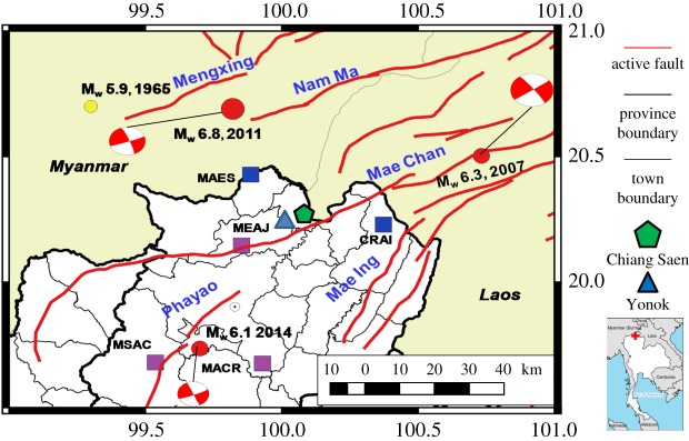
In contrast to earlier records, accounts of the 460 A.D. earthquake seem to provide the most reliable evidence, since several kinds of geological evidence could still be observed [12]. According to the available written resources, the 460 A.D. earthquake severely damaged Yonok city (figure 1), the former capital city of Sinhanavati Kingdom. The current location of Chiang Saen is located about 3 km away from the previous site where significant damage was reported including large-scale liquefaction with most parts of the city submerged under water. The 185-km long left-lateral strike-slip Mae Chan fault is believed to have been responsible for the inundation of Yonok town due to its proximity to the ancient town. This is in agreement with several studies indicating that the Mae Chan fault once produced a major earthquake around 400–500 A.D. [12–14]. The Mae Chan fault is believed to have generated the 16 May 2007 Mw 6.3 earthquake in Bokeo, Laos. The focal mechanism solution of the 2007 event from the Global CMT database indicates a left-lateral strike-slip with a strike of 54 degrees and a dip of 89 degrees. The depth of the 2007 event was reported as 9 and 12.6 km by USGS and Global CMT, respectively. However, there has been no earthquake greater than magnitude 5.0 since 1902 for Mae Chan segment in Northern Thailand based on the ISC-GEM earthquake catalogue [15]. Based on the offset of the youngest geomorphic features, Fenton et al. [16] estimated the long-term slip rates for the Mae Chan fault between 0.3 and 3 mm/year. If one assumes the fault rupture length to be 118 km and 0.3–3 mm yr−1 slip rates, a Mw 7.5 earthquake magnitude would occur every 11 000 to 1100 years on this segment. The recurrence interval for the characteristic earthquake is determined as follows:
| 2.1 |
Figure 1.
Chiang Saen and its surrounding seismicity from earthquakes greater than 5.0 since 1902. The red lines represent active faults from the Department of Mineral Resources (DMR) (http://www.dmr.go.th/main.php?filename=fault_en). The blue and purple squares represent seismic stations that record ground motion from Mw 6.8 2011 and Mw 6.1 2014, respectively.
where μ is shear modulus and is set equal to 3.0 × 10¹¹ dyne cm−2, L is the rupture length (118 km), and W is the rupture width (15 km), ů is the fault slip rate, M0c is the characteristic earthquake moment [17], which is calculated as follows:
| 2.2 |
(b). Nam Ma fault
The other major active fault in this area is the Nam Ma fault with NE–SW oriented striking faults. This fault runs from the northwestern part of Laos to eastern Myanmar. Lacassin et al. [18] used the mosaic of SPOT multispectral images to identify the geomorphic evidence of residual right lateral bends that remain after restoring the left-lateral offset, which is about 30 km distance along the Mekong river with the estimated slip rate based on the relationship of river offsets between 0.6 and 2.4 mm yr−1, which is in agreement with the slip rates of other faults in this region. Ongoing small earthquake magnitudes along this fault were commonly observed. The Mw 6.8 earthquake on 24 March 2011 occurred along the western segment of the Nam Ma fault, and is located about 45 km from Chiang Saen, causing partial damage to historical monuments. By assuming 4 m fault slip at depth represents the characteristic slip on the Tarlay segment, Wang et al. [19] suggested the average recurrence interval of a Tarlay earthquake event between 1600 and 6500 years along the western section.
(c). Mae Ing fault
The origin of this fault is located in Laos PDR and partly extends inside Chiang Rai, Northern Thailand. Kosuwan et al. [20] inferred the location of this fault by using geological and Landsat images. Several earthquakes with magnitudes ranging from ML 2.8 to 4.2 have been instrumentally recorded around this fault. The fault slip rate determined from river offsets in relation to the ages of rocks by Lacassin et al. [18] indicates a minimum slip rate of around 0.3–0.75 mm yr−1 and a maximum slip rate of around 1.2–3 mm yr−1.
(d). Mengxing fault
Situated in the Eastern Myanmar and Southern China borders, the Mengxing fault makes up the northwest boundary of the undeformed Sundaland block. The estimated maximum slip rate of the strike-slip motion on this NE–SW fault as demonstrated by Simons et al. [21] is between 2 and 4 mm yr−1 and is in approximate agreement with the estimate based on river offsets suggested by Lacassin et al. [18]. Offset measured on this fault along Nam Loi river, about 24 km, is in the same order of magnitude as those of the other regional faults (e.g. Nam Ma fault), and they probably correspond to total upper Coenozoic offsets, which can be interpreted into a slip rate of around 1.2–5 mm yr−1 [18]. Although in recent times there have been no earthquakes with magnitude above 6 generated from this fault, the observed seismicity with magnitude around 4–5 confirms that this fault is still active. The largest recorded earthquake in this fault zone is a MW 5.9 earthquake on 22 September 1965.
(e). Phayao fault
Parts of this fault are located in Phayao province, while the northern segment extends toward the central part of Chiang Rai province. Clear scarp could be detected on satellite maps, the indicating Quatermary movement with the eastern part located next to the Phayao basin [12]. This 90-km NNW active fault is responsible for a few moderate earthquakes in Thailand, including the 5.2 Mw 1994 Pan and 6.1 Mw 2014 Mae Lao earthquakes. These earthquake focal mechanisms are normal and left-lateral strike-slip faults well consistent with the geologic data for basin bounding normal faults. Fenton et al. [16] assumed a slip rate for the Phayao of about 0.1 mm/year (table 2).
Table 2.
Recorded ground motion from Mw 6.8, 24 March 2011 Tarlay earthquake with their National Earthquake Hazards Reduction Program (NEHRP) site class.
| ground motion |
||||||
|---|---|---|---|---|---|---|
| station | NEHRP site class | Rjb (km) | distance from Chiang Saen (km) | PGA (g) | PGV (cm s−1) | D5-D95 (s) |
| MAES | D | 28 | 28 | 0.20 | 12.7 | 10 |
| CRAI | C | 64 | 31 | 0.07 | 5.1 | 16 |
3. Observed ground motion
With the availability of recorded ground motion, it could be useful to examine general characteristics of strong motion records, which could in turn be valuable for future studies. The strong ground motion from Mw 6.8, 24 March 2011 and Mw 6.1, 5 May 2014 events have been recorded by seismic stations operated by the Thai Metrological Department (TMD) (tables 3 and 4). In addition, the TMD seismic network has only been in complete operation since 2008, so there is no recorded ground motion from the 2007 event. The Mw 6.8 earthquake in 2011 caused partial damage to the top part of Chedi Luang, which is the highest ancient pagoda in Chiang Saen. The highest PGA of 0.20 g was recorded at Mae Sai station (MAES). This station is located about 28 km from Chiang Saen town; however, the observed damaged in Mae Sai is much higher than for residential buildings in Chiang Saen, so no direct comparison with this recorded ground motion could be used. The other nearest station to Chiang Saen, which could help to explain the observed damage to ancient stupas, is CRAI station, which is located 31 km from Chiang Saen and has a recorded PGA of 0.07 g. The comparison between observed strong motion and global empirical equation had been provided by Ornthammarath [1], and they are in fair agreement over the considered distance range. The ground motion in Chiang Saen is likely to be affected by local soil amplification since it is situated near Mekong river. The estimated PGA in Chiang Saen based on Boore & Atkinson's [22] ground motion model was 0.10 g in Chiang Saen for Vs30 = 760 m s−1.
Table 3.
Recorded ground motion from Mw 6.1, 5 May 2014 Mae Lao earthquake with their National Earthquake Hazards Reduction Program (NEHRP) site class. (Online version in colour.)
| ground motion |
||||||
|---|---|---|---|---|---|---|
| station | NEHRP site class | Rjb (km) | distance to Chiang Saen (km) | PGA (g) | PGV (cm s−1) | D5-D95 (s) |
| MEAJ | D | 38 | 29 | 0.04 | 2.5 | 19.5 |
Table 4.
Summary of observed damage to ancient monuments from 2011 Tarlay earthquake.
| name | Chedi Luang | Chedi Pasak | Pu Khao Temple | Chedi Prasad Khum |
|---|---|---|---|---|
| damage state | moderate | partial | moderate | moderate |
| structural type | stupa | stupa | arch and masonry solid core load bearing system | stupa |
| construction period | fourteenth century | fourteenth century | fourteenth century | seventeenth century |
| height (m) | 35 | 21 | 4 | 8 |
| ground floor solid core (m) | 9 | 11 | 4 | 2.5 |
| height/solid core width ratio | 3.88 (35/9) | 1.9 (21/11) | 1 (4/4) | 3.2 (8/2.5) |
| total base width (m) | 26 | 14.6 | 4 | 8 |
| number of stories | 1 | 2 | 1 | 1 |
| after 2011 Mw 6.8 |  |
 |
 |
 |
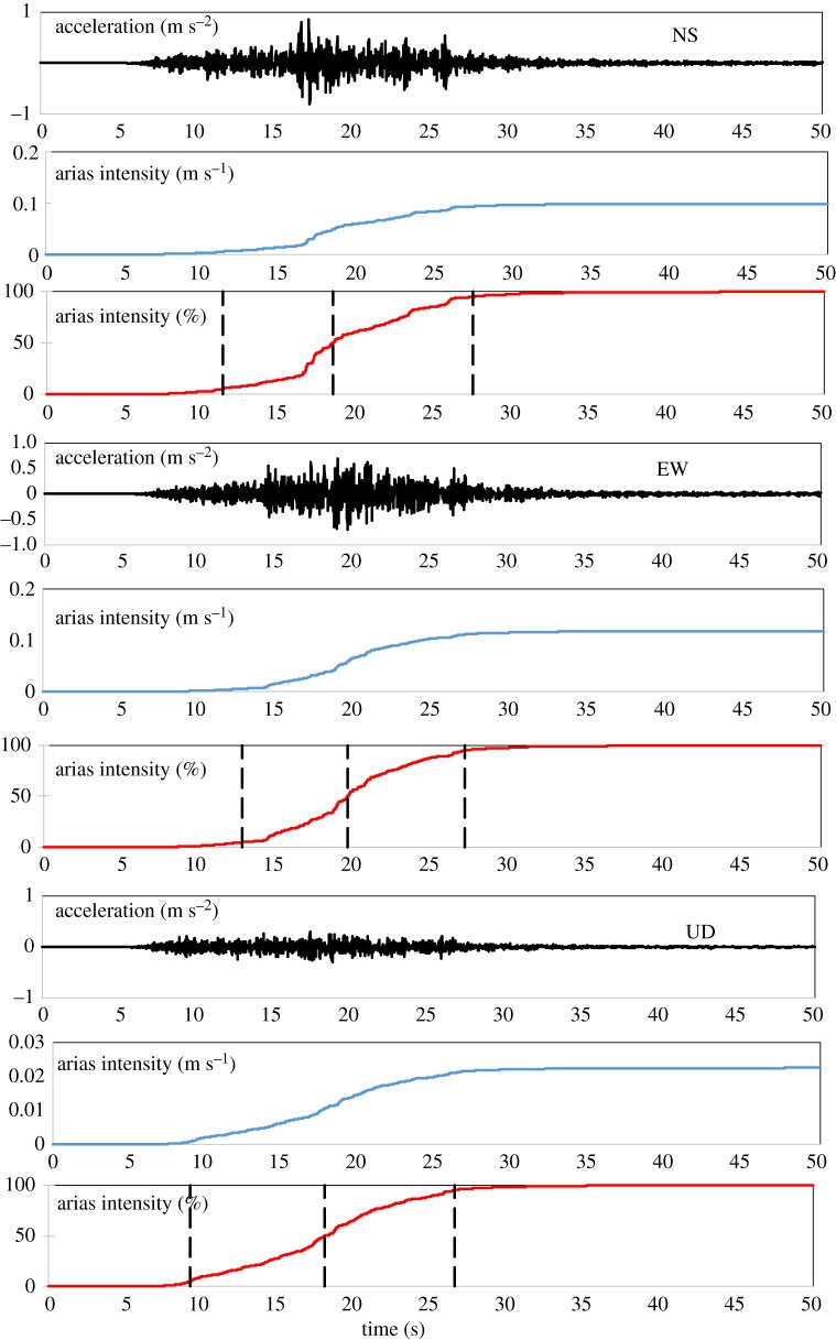
The recorded PGA at CRAI station for north–south (NS), east–west (EW) and up–down directions are 0.08 g, 0.07 g and 0.03 g, respectively. Figure 2 displays acceleration and Arias intensity time history and percentage of Arias intensity at CRAI station. Arias intensity has generally been used as an indicator of total seismic energy content within ground motion [23]. Each ground motion record has been visually checked for any notable error, and basic zero-order baseline correction has been performed for each accelerogram. Owing to the relatively moderate distance from the seismic source, separation between the first arrival P wave and high amplitude surface wave between 6 and 18 s could be noted. The initial P- and S-wave arrival times could be located at 5.38 and 13.90 s, respectively. The time difference between P- and S-waves, about 8.52 s, is well aligned with the hypocentral distance of Tarlay earthquake, of about 68 km. The energy release in both horizontal accelerograms develops quickly when the S-wave begins to arrive. The significant duration, which is the 5% and 95% of the Arias intensity (AI) (the first and third dash lines, respectively), EW direction is mounted up within 14 s, while the significant duration in the NS direction is around 16 s. By contrast, a longer significant duration in vertical direction, 18 s, could be observed. For Arias intensity time history, Figure 2, it could be clearly seen that a large proportion of energy is developed upon surface wave arrival with Arias intensity reaches to 0.10, 0.11 and 0.02 m s−1 in NS, EW and vertical component, respectively.
Figure 2.
Recorded ground acceleration and arias intensity and percentage of arias intensity time history at CRAI station from Mw 6.8, 24 March 2011 earthquake with Joyner-Boore distance of 64 km. (Online version in colour.)
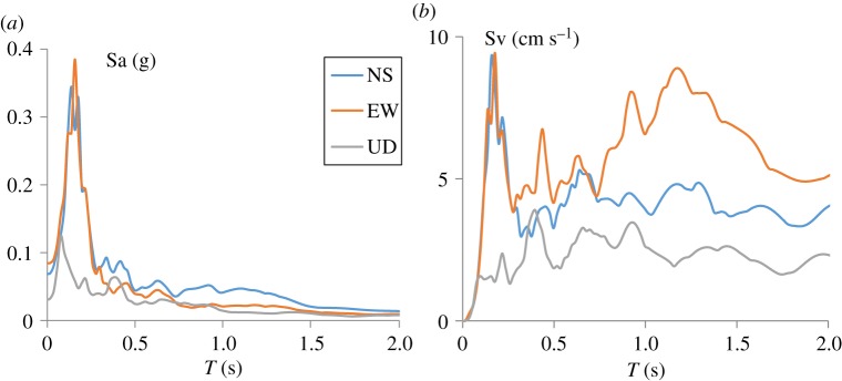
In addition, horizontal and vertical spectral acceleration are shown in figure 3a, and both horizontal spectrums contain similarly large energy within short periods (from 0.1 to 0.3 s) with the highest spectral ordinate at about 0.4 g. A similar level of ground excitation could be recorded from the 24 August 2016 Mw 6.8 Chuak earthquake in Myanmar, which caused a large amount of damage to historical monuments in Bagan [24]. By contrast, at long period (T > 1 s), EW direction velocity spectra is relatively higher than NS direction velocity spectra, which might be due to the shorter significant duration observed in the EW component.
Figure 3.
(a) Horizontal and vertical acceleration and (b) velocity response spectra recorded at CRAI station from Mw 6.8, 24 March 2011.
4. Damage to historical monuments
In general, historical monuments in Chiang Saen are stupa (or chedi), which is the solid dome shape structural type made from masonry with lime and natural fibre mortars. It is considered to be the most respected religious structure for Buddhists. Originally, it contained some relics of Lord Buddha. Later it contained king or high ranking monk relics; eventually it has become a Buddhist symbol similar to the cross for Christianity or Star of David for Judaism. The first model of the stupa originates from India. Its structure is made of three parts: basement (drum), the tumulus (dome) surrounded by a cubical chair symbolizing the seat of Buddha, and the chat at the top. Originally, the top had only one tier, but during the later development it became a slender pinnacle formed by many tiers. Most Northern Thailand stupas have a square solid mass at the basement and each side contains Buddha images in high relief or round relief. This square basement is overlaid by one or more stories and crowned by the domed stupa. If the structure is hollow, then one of the niches serves as an entrance door. The common damage pattern to these types of structures is seen at the top spire, which is due to dynamic characteristic leading to amplified shaking at the top spire, which leads to considerably damaged even low-intensity ground shaking, i.e. MMI 6.
(a). Chedi Luang (latitude 20.273152 N, longitude 100.080312 E)
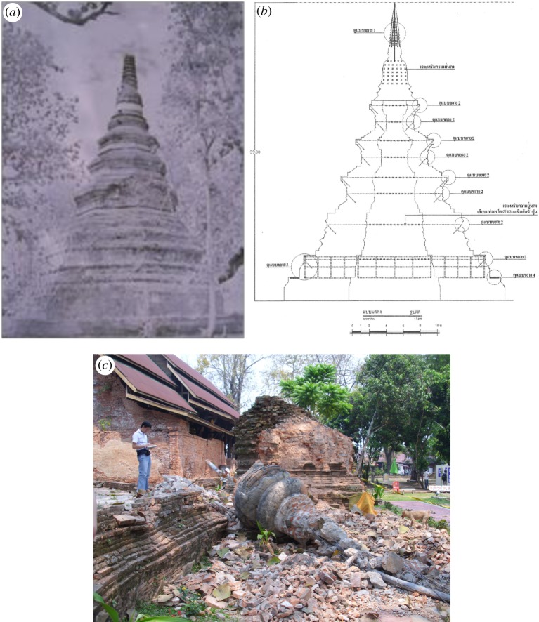
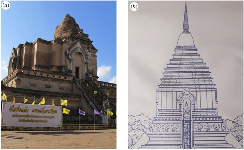
Most historical monuments in Chiang Saen have been constructed since the fourteenth century (table 4). Some of them have been partially damaged in recent earthquakes, but several ancient stupas and temples in Chiang Saen town appear to have survived those events, and a very large number of ancient monuments still remain. In addition, several of them are inscribed in the Thai heritage list, which is legally protected by the Thai government. The national heritage list also allows the government to allocate funding to the Department of Fine Arts to launch conservation programmes for the listed monuments. The most important stupa in Chiang Saen is Chedi Luang (figure 4); this stupa has an octagonal base with superimposed platform up to the bell and a height of 35 m, making it the highest stupa in Chiang Saen. According to Lan Na and Chiang Mia chronicles [4,10], the original stupa was built in 1328 and its former height was 58 m; however, significant retrofitting was performed in 1515 [25], which is confirmed by its dome shaped architectural features in the Lan Na architectural style from the sixteenth century instead of a square solid mass [26].
Figure 4.
(a) The early photograph of Chedi Luang in 1957 (DOFA, 1979). (b) The schematic cross-section of Chedi Luang with reinstalled top spire in 2012. (c) The collapse of the 7-m spire due to the Mw 6.8 Tarlay earthquake in 2011. Its size is comparable to a person next to the toppled spire. A steel pipe could be clearly seen. (Online version in colour.)
After the 2011 earthquake, significant damage mainly occurred at the spire and dome. The collapse of the top spire caused additional damage to the tumulus part with large cracks as well as damage to other nearby structures. The 7-m toppled spire seems to indicate that similar damage might have occurred in the past since a steel pipe could be observed inside the fallen summit. Based on local interviews, the previous retrofitting was due to thunder strikes, which caused damage to the top of the stupa. The previous work did not seem to consider preventing damage due to earthquakes. However, the current Thai seismic design code does not have clear specific guidelines related to ancient monuments, and most retrofit work does not appear to prevent future earthquake damage. Nevertheless, the structure at the basement is still intact, and no intervention works need to be done for this part. Later, the top masonry spire was reinstalled by the Department of Fine Arts in 2012. However, additional damage occurred due to the Mw 6.1 2014 Mae Lao earthquake, which was located about 70 km from Chiang Saen. In 2014, wide cracks at the upper part of the dome and some parts of the top spire were observed. An additional factor that could explain the damage to Chedi Luang is its slenderness ratio (height per width of solid core) of about 3.88 (35/9), compared with other historic structures in Chiang Saen which sustained much less damage given the low ground shaking recorded at MEAJ station (PGA = 0.04 g), which is located about 30 km away from Chiang Saen. Since the modal periods of historical structures depend highly on the height, total mass, flexural stiffness and its configuration, Chedi Luang might have suffered extensively from the long period of moderate earthquakes from nearby active faults throughout the last 500 years. The early photograph of Chedi Luang in 1957 showed that the top spire was missing, indicating the high vulnerability of this ancient structure.
(b). Chedi Pasak (latitude 20.274108 N, longitude 100.076804 E)
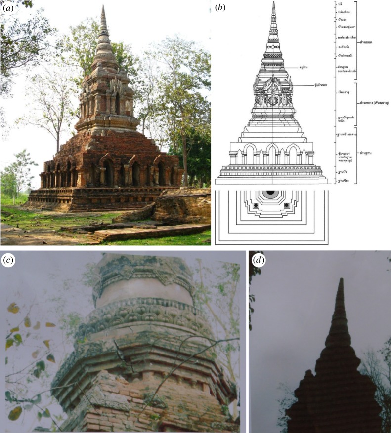
The other ancient monument in Chiang Saen that was damaged due to recent earthquakes is Chedi Pasak (figure 5). Based on the available historical records, this masonry stupa was built in 1332 in the same period as Chedi Luang. In contrast to Chedi Luang, the architectural form of Chedi Pasak is similar to the Bagan and Hariphunchai styles, which are quite common for the early Lan Na period. There is no historical record of severe damage and any significant repair works for Chedi Pasak. In addition, the original architectural form in the early fourteenth century [4,26], is still preserved. Due to a 2011 Mw 6.8 earthquake, partial damage occurred to this stupa, including wide cracks in the lower top part and clear tilt to the spire. This stupa has symmetrical planes in horizontal and vertical directions. The solid core basement is about 11 by 11 m, and it is the load bearing of the superstructure which is about 21 m in height, making it the second highest stupa and one of the oldest in Chiang Saen. However, no significant additional damage could be observed following the 2014 Mae Lao earthquake. In addition, Chedi Pasak is located within the old city centre and about 300 m from Chedi Luang, but different observed damage could be clearly noted. It is worth mentioning that its slenderness ratio is 1.9 (21/11), about half of Chedi Luang, which might partly explain the lower observed damage. However, due to its architectural characteristics and construction materials, it is quite clear that this masonry structure is also vulnerable to strong ground shaking from nearby active faults.
Figure 5.
(a) Chedi Pasak before 2011 earthquake. (b) The schematic plot of Chedi Pasak in different layers. (c) Observed wide cracks at the lower top part. (d) Tilt could be clearly seen at the top spire following the 2011 earthquake in Myanmar located at 50 km to Chiang Saen. (Online version in colour.)
(c). Pu Khao temple (latitude 20.352774 N, longitude 100.081782 E)
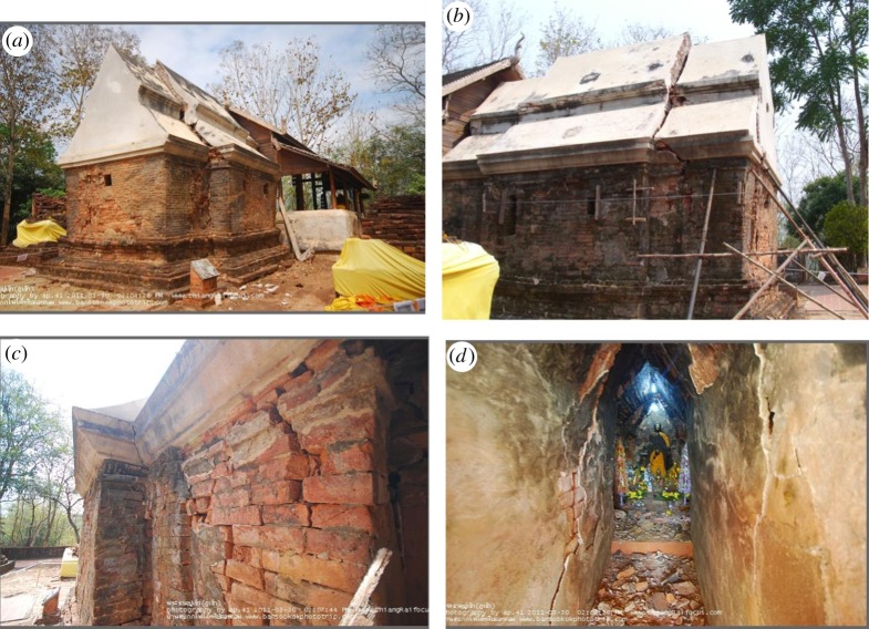
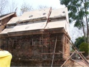
The only masonry arch structure in Chiang Saen to be heavily damaged by the 2011 Myanmar earthquake was the Pu Khao Temple (figure 6). This one-storey temple is characterized by multi-arch structures. The double-tier roof temple has a symmetric rectangle floor plan sitting on a masonry basement. Brick masonry walls of about 50-cm thickness with 4-m height, which are the main load bearing system, have severe diagonal shear in-plane damage in all directions. Extensive cracks could be clearly observed in both interior and exterior walls. The level of in-plane damage to bearing wall could trigger partial or full out-of-plane collapse of damaged structures. Damage between walls due to pounding could be observed clearly at masonry corners. The architectural form of the double-tier roof indicates that it has been constructed since the fourteenth century. The scale of the damage led to fear of full collapse and temporary scaffoldings were installed to prevent further damage from aftershock. Based on the observed MMI VI and estimated 0.10 g PGA in this area as discussed in Section 3, the observed near collapse of historical structure under this level of ground shaking clearly indicates poor seismic performance of ancient monuments in this region.
Figure 6.
(a) Pu Khao temple damage due to 2011 earthquake viewed from NE. (b) The same photograph viewed from SW. (c) Observed wide cracks at exterior walls. (d) Diagonal in-plane shear cracks could be clearly seen. (Online version in colour.)
(d). Chedi Prasad Khum (latitude 20.273161 N, longitude 100.086136 E)
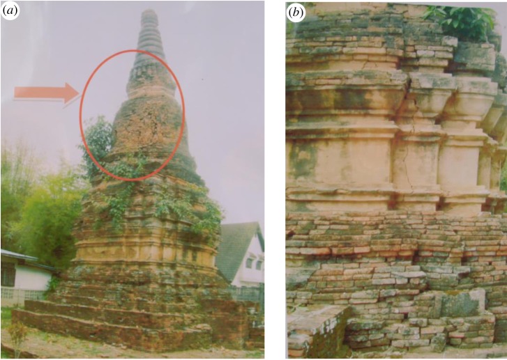
Chedi Prasad Khum (figure 7), is the only monument included in the damage survey to have been constructed in the seventeenth century, which is evident from its torus moulding architectural feature. This solid chedi was constructed of brick and mortar with a high rabbeted lotus base measuring 8 m in width and height. This has a round bell shape top with a long spire, which was a common style during the late Lan Na Kingdom. Apparent damage due to the 2011 earthquake occurred at the drum with a 5–7 cm width crack, and subsidence in parts of the superstructures could be clearly seen. In addition, vertical cracks propagated through the height of the basement, indicating the large vibration developing along the height of the structure. During vibration, the maximum displacement occured at the top part, and the lateral inertia force is responsible for the increasing tension stress at the top spherical cone and drum part, while compressive stress mostly occurs along the basement. Since masonry structures were designed to carry self-weight in compression, less damage could be expected in the basement. However, the developed tensile stress distributed along the drum and top parts exceeds the tensile strength of masonry, and severe damage clearly confirms this shaking behaviour.
Figure 7.
(a) Apparent settlement for parts of superstructures at Chedi Prasad Khum due to 2011 earthquake. (b) Observed long cracks along the basement. (Online version in colour.)
5. What shaking intensity would cause the ancient monuments to collapse?
Based on the recent damage to ancient structures in Chiang Saen, these historical masonry monuments sustained minor to moderate damage due to moderate earthquakes from nearby active faults with MMI intensity between IV and VI as reported in the studies by Ruangrassamee et al. [3], Ornthammarath [1] and Ornthammarath and Warnitchai [2]. One could develop the three-dimensional finite-element model to analyse these ancient monuments to estimate what shaking level would cause these ancient monuments to collapse. However, the existing material properties of these ancient monuments are currently not possible to determine given the destructive testing would cause irreparable damage to existing monuments. In the end, different material properties need to be assumed, and the analysis results could be dependent on the involved assumption. However, a numerical model is indeed important to provide overall structural behaviour and structural collapse potential, which would be adopted in further studies.
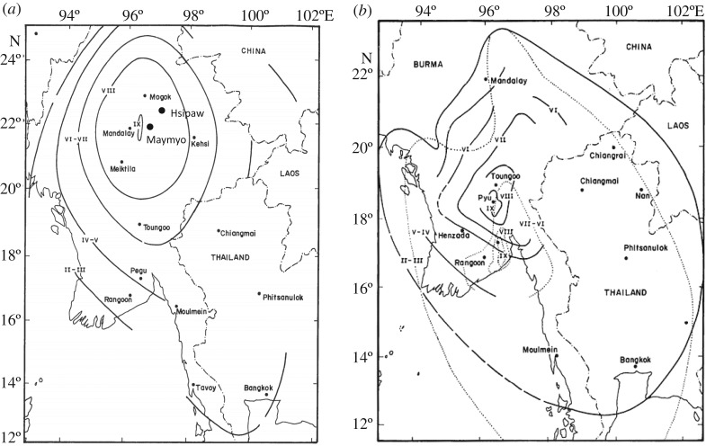
On the other hand, it would be useful to review the past observed damage to similar structures (i.e. stupa) located in the surrounding region to constrain the upper bound of the MMI intensity at which point these pagodas collapse. This is due to the fact that these pagodas have brittle brick masonry as a major structural component with no lateral load resisting system. These pagodas have only a compressive arch load transferring system to sustain their own gravity load. These structures have no engineering design consideration to sustain high intensity level, and hence, the intensity saturation could be expected [27,28]. One of the first earthquakes that occurred in the surrounding study area, which completely demolished all pagodas within the epicentral region, was the violent earthquake of Mw 7.8 that occurred on 23 May 1912 in Shan State, Myanmar [29,30]. The second earthquake that could outline the upper bound intensity of stupa occurred on 4 December 1930 with a magnitude of 7.5 in Pyu, Myanmar [31]. In tables 5 and 6, the estimated shaking intensities in and around the epicentral area are listed as reported by Brown [29], Chhibber & Ramamirtham [30] and Brown & Leicester [31]. For these two earthquakes in Myanmar, the reported intensity was mainly in the Rossi–Forel's (RF) scale, which might be different to the MMI scale used in this study. The descriptions of observed damage to local buildings by Brown [29], Chhibber & Ramamirtham [30] and Brown & Leicester [31] were used to assign the MMI scale in this study. This reported damage was carefully interpreted to give summary information based on the vulnerability class and damage grade according to the European Macroseismic Scale (EMS-98) [32]. An unreinforced masonry building was listed under the vulnerability class A; a timber building with brick nogging infill wall was classified as class C. For damage grades, grades 1 to 5 should represent observed damage to structures. Damage grade 1 is assigned to no damage, and damage grade 5 is assigned to collapse buildings. In tables 5 and 6, reported damage as well as damage grade and vulnerability class are provided.
Table 5.
Reported damage to local buildings and pagoda due to Mw 7.8, 23 May 1912 Shan earthquake, Myanmar. Approximated distance determined from rupture area proposed by Wang et al. [19]).
| town | Rossi–Forel's (RF) scale | MMI scale | description |
|---|---|---|---|
| Mandalay (distance, 55 km) | IX [29,30] | VIII |
|
| Maymyo (distance, 15 km) | VIII [29,30] | ≥VII |
|
| Hsipaw (distance, 50 km) | VIII [29,30] | ≥VII |
|
| Toungoo (distance, 180 km) | VII [29,30] | V |
|
Table 6.
Reported damage to local buildings and pagodas due to Mw 7.5, 4 December 1930 Pyu earthquake, Myanmar. Approximated distance determined from rupture area proposed by Wang et al. [19]).
| town | Rossi–Forel's (RF) scale | MMI scale | description |
|---|---|---|---|
| Pyu (distance, 10 km) | IX [30,31] | VIII |
|
| Toungoo (distance, 25 km) | VIII [30,31] | ≥VII |
|
Based on the past damage to similar structures in Myanmar, it is unlikely that ancient monuments in Chiang Saen should survive any ground shaking greater than MMI and greater than or equal to VII without damage or collapse. The weight of the superstructure would easily bring down the entire Chedi Pasak and other previously described monuments. Had collapse occurred, it should be observed through different architectural forms for several structures in Chiang Saen; however, the fourteenth century original summit in Chedi Pasak is still preserved as well as other structures in the present day [26]. It is also worth mentioning that several stone inscriptions and the remains of damaged stupas indicate the total structural collapse since the thirteenth century due to earthquakes from other parts of Lan Na kingdom, in the present day Northern Thailand [10,13,33] (figure 8 and 9).
Figure 8.
Rossi–Forel's (RF) isoseismal map for (a) the Mw 7.8, 23 May 1912 Shan earthquake, Myanmar [29] and (b) the Mw 7.5, 4 December 1930 Pyu earthquake, Myanmar [31]. Reported damage to towns in tables 5 and 6 is shown according to the observed damage from past studies.
Figure 9.
(a) The current ruin of Chedi Luang in Chiang Mai due to the 1545 earthquake. (b) The schematic sketch of the original Chedi Luang before collapse due to earthquake with height of 95 m. (Online version in colour.)
To better constrain this assumption, the macroseismic intensity prediction equation (IPE) for active crustal region developed by Allen et al. [34] has been adopted with characteristic earthquake magnitudes and closest rupture distances (Rrup) to Chiang Saen of active faults previously discussed in Section 2. The characteristic earthquake magnitudes are estimated from the expected rupture length for the mapped faults, which may be limited by fault segmentation, by using the relation proposed by Wells and Coppersmith [35]. In addition, different earthquake scenarios on these active faults are taken into account by assuming multiple segment ruptures (table 7).
Table 7.
List of different earthquake scenarios from five major active faults near Chiang Saen considered in this study.
| Mw (rupture length, km) |
|||||
|---|---|---|---|---|---|
| no. | fault name | Rrup (km) | scenario 1 | scenario 2 | scenario 3 |
| 1 | Mae Chan | 5 | 6.8 (29 km) | 7.5 (150 km) | 7.8 (230 km) |
| 2 | Mae Ing | 41 | 7.1 (62 km) | 7.5 (142 km) | — |
| 3 | Phayao | 43 | 6.8 (29 km) | 7.2 (65 km) | — |
| 4 | Nam Ma | 46 | 6.8 (30 km) | 7.5 (134 km) | 7.8 (207 km) |
| 5 | Meng Xing | 67 | 7.1 (51 km) | 7.3 (81 km) | 7.8 (237 km) |
Based on scenario 1, a simple-segment rupture, the estimated intensity for considered faults excluding the Mae Chan fault could vary between V and VI (figure 10), which is similar to the observed shaking intensity from recent earthquakes causing minimum to moderate damage to Chiang Saen's ancient monuments. For multiple-segment ruptures, scenario 2 and 3, larger intensity could be expected, and the range of estimated intensity apart from the Mae Chan fault might vary from VI to VII (figure 10). Heavy damage to ancient monuments in Chiang Saen should be expected if an earthquake of magnitude 7.8 should occur similar to the 23 May 1912 Shan earthquake, Myanmar. Although estimated intensity based on the IPE model may not provide the accurate prediction of felt intensity, it could provide us with the first-order assessment and possible earthquake scenarios, which could in turn guide structural engineers in performing appropriate structural assessment. However, decisive conclusions about earlier historical events based on the observed damage to ancient monuments in Chiang Saen seem to be questionable at best from other nearby active faults apart from the Mae Chan fault. Chiang San has been populated since the thirteenth century, and these historical monuments have survived until now, so this might allow us to interpret that at least since the fourteenth century this area did not suffer severe ground shaking similar to the 460 A.D. earthquake from the Mae Chan fault. Further research on other historical monuments in other major cities in the Golden Triangle area could allow us to understand the basis of earthquake cycles from other active faults in this area [36]. By contrast, there is a possibility that different earthquake scenarios might explain the significant retrofitting of Chedi Luang in 1515 [4,10,26], but there is no clear historical record to support this hypothesis. The 1715 earthquake ground shaking in Chiang Saen might be similar to the 2011 earthquake due to moderate earthquakes (M > 6) at moderate distances (between 40 and 60 km) along any nearby active faults, which have been previously mentioned (table 7).
Figure 10.
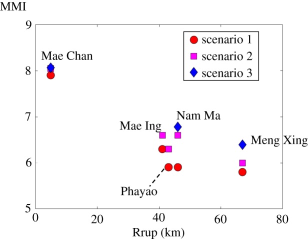
Estimated intensity using macroseismic intensity prediction equation for active crustal region developed by Allen et al. [34] based on five major active faults located in and around Chiang Saen with different earthquake scenarios as reported in table. (Online version in colour.)
6. Conclusion
In this work, damage to ancient masonry monuments in Chiang Saen due to recent earthquakes has been assessed. It is found that only partial to moderate damage could be observed due to moderate earthquakes from nearby active faults with MMI ranging from IV to VI. The existence of several vulnerable masonry structures from the last 600 years suggests that ground shaking greater than MMI VII might have not occurred since the fourteenth century. These historic structures had been damaged by earlier tremors; however, ground acceleration from historic earthquakes has not been enough to destroy these vulnerable monuments. This might suggest that most historical events have involved only partial failures for each segment. Should Mae Chan fault produce a similar earthquake to that which inundated Yonok town in 460 A.D., these structures are unlikely to survive. However, our analysis is insufficient to draw conclusion for pre-1515 and 1715 events from other nearby active faults, although it could be useful to help solve historic earthquakes through further paleoseismological studies in the Golden Triangle area.
Acknowledgement
The author would like to sincerely thank local historians and authorities in Chiang Saen for several historical and other and insights during field survey. In addition, the author thanks John Douglas and an anonymous reviewer for numerous helpful suggestions that have clarified the text.
Data accessibility
Strong ground motion data can be obtained through the author's email address: teraphan.orn@mahidol.edu
Competing interests
We declare we have no competing interests.
Funding
This project is partially supported by the European Union's Horizon 2020 Research and Innovation Programme RISE under grant agreement no. 730888 (RESET). The author is supported by the Thailand Research Fund, Office of the Higher Education Commission under contract No. MRG6180284, and it is gratefully acknowledged.
References
- 1.Ornthammarath T. 2013. A note on the strong ground motion recorded during the MW 6.8 earthquake in Myanmar on 24 March 2011. Bull. Earthq. Eng. 11, 241–254. ( 10.1007/s10518-012-9385-4) [DOI] [Google Scholar]
- 2.Ornthammarath T, Warnitchai P. 2016. The 5 May 2014 MW 6.1 Mae Lao (Northern Thailand) earthquake: interpretations of recorded ground motion and structural damage. Earthq. Spectra 32, 1209–1238. ( 10.1193/081814EQS129M) [DOI] [Google Scholar]
- 3.Ruangrassamee A, Ornthammarath T, Lukkunaprasit P. 2012. Damage due to 24 March 2011 M6.8 Tarlay earthquake in Northern Thailand. In Proceeding of the 15th world conference in earthquake engineering, Lisbon, Portugal. [Google Scholar]
- 4.Ongsakul S. 2005. History of Lanna, 342 p Chiang Mai, Thailand: Silkworm Books. [Google Scholar]
- 5.Bilham R, Bali BS. 2014. A ninth century earthquake-induced landslide and flood in the Kashmir Valley, and earthquake damage to Kashmir's Medieval temples. Bull. Earthq. Eng. 12, 79–109. ( 10.1007/s10518-013-9504-x) [DOI] [Google Scholar]
- 6.Fäh D, et al. 2009. The 1356 Basel earthquake: an interdisciplinary revision. Geophys. J. Int. 178, 351–374. [Google Scholar]
- 7.Shedlock KM, Giardini D, Grünthal G, Zhang P. 2000. The GSHAP global seismic hazard map. Seismol. Res. Lett. 71, 679–689. ( 10.1785/gssrl.71.6.679) [DOI] [Google Scholar]
- 8.Ornthammarath T, Warnitchai P, Worakanchana K, Zaman S, Sigbjörnsson R, Lai CG. 2011. Probabilistic seismic hazard assessment for Thailand. Bull. Earthq. Eng. 9, 367–394. ( 10.1007/s10518-010-9197-3) [DOI] [Google Scholar]
- 9.Nutalaya P, Sodsri S, Arnold EP. 1985. SEASEE series on seismology, vol. II—Thailand. Southeast Asia Association of Seismology and Earthquake Engineering and U.S. Geological Survey. Denver, CO: United States Geological Survey. [Google Scholar]
- 10.Wyatt DK, Wichienkeeo A. 1995. The chiang Mai chronicle, 352 p Chiang Mai, Thailand: Silkworm Book. [Google Scholar]
- 11.Lukkunaprasit P, Ruangrassamee A, Boonyatee T, Chintanapakdee C, Jankaew K, Thanasisathit N, Chandrangsu T. 2016. Performance of structures in the Mw 6.1 Mae Lao earthquake in Thailand on May 5, 2014 and implications for future construction. J. Earthq. Eng. 20, 219–242. ( 10.1080/13632469.2015.1051636) [DOI] [Google Scholar]
- 12.Morley CK, Charusiri P, Watkinson IM. 2011. Structural geology of Thailand during the Cenozoic. In The geology of Thailand (eds Ridd MF, Barber AJ, Crow MJ), pp. 273–334. Geological Society of London. [Google Scholar]
- 13.Penth H. 2006. Earthquakes in old Lan Na: a part of natural catastrophes. Chiang Mai Univ. J. 5, 255–265. [Google Scholar]
- 14.Shi X, Wang Y, Sieh K, Weldon R, Feng L, Chan C-H, Liu-Zeng J. 2018. Fault slip and GPS velocities across the Shan Plateau define a curved Southwestward crustal motion around the eastern Himalayan Syntaxis. J. Geophys. Res. Solid Earth 123, 2502–2518. ( 10.1002/2017JB015206) [DOI] [Google Scholar]
- 15.Di Giacomo D, Engdahl ER, Storchak DA. 2018. The ISC-GEM Earthquake Catalogue (1904–2014): status after the extension project. Earth Syst. Sci. Data 10, 1877–1899. ( 10.5194/essd-10-1877-2018) [DOI] [Google Scholar]
- 16.Fenton CH, Charusiri P, Wood SH. 2003. Recent paleoseismic investigations in northern and western Thailand. Ann. Geophys. 46, 957–981. [Google Scholar]
- 17.Hanks TC, Kanamori H. 1979. A moment magnitude scale. J. Geophys. Res. 84, 2348–2350. ( 10.1029/JB084iB05p02348) [DOI] [Google Scholar]
- 18.Lacassin R, Replumaz A, Hervé Leloup P. 1998. Hairpin river loops and slip-sense inversion on southeast Asian strike-slip faults. Geology 26, 703–706. () [DOI] [Google Scholar]
- 19.Wang Y, Sieh K, Tun ST, Lai KY, Myint T. 2014. Active tectonic and earthquake Myanmar region. J. Geophys. Res. 119, 3767–3822. ( 10.1002/2013JB10762) [DOI] [Google Scholar]
- 20.Kosuwan S, Takashima I, Charusiri P. 2004. Active Fault Zones in Thailand. Bangkok: Department of Mineral Resources. See http://www.dmr.go.th/main.php?filename=fault_en (accessed 17 July 2019).
- 21.Simons W, et al. 2007. A decade of GPS in SE Asia: resolving Sundaland motion and boundaries. J. Geophys. Res. 112, B06420 ( 10.1029/2005JB003868R) [DOI] [Google Scholar]
- 22.Boore DM, Atkinson GM. 2008. Ground-motion prediction equations for the average horizontal component of PGA, PGV, and 5%-damped PSA at spectral periods between 0.01s and 10.0s. Earthq. Spectra 24, 99–138. [Google Scholar]
- 23.Travasarou T, Bray JD, Abrahamson NA. 2003. Empirical attenuation relationship for Arias intensity. Earthq. Eng. Struct. Dyn. 32, 1133–1155. ( 10.1002/eqe.270) [DOI] [Google Scholar]
- 24.Zaw SH, Ornthammarath T, Poovarodom N. 2019. Seismic reconnaissance and observed damage after the Mw 6.8, 24 August 2016 Chauk (Central Myanmar) earthquake. J. Earthq. Eng. 23, 284–304. ( 10.1080/13632469.2017.1323050) [DOI] [Google Scholar]
- 25.Department of Fine Arts. 1973. Collection of Annals, Section 61, Bangkok. See http://www.digitalcenter.finearts.go.th/book/show-product/5167 (accessed 25 June 2019) [in Thai].
- 26.Saisingha S. 2017. Stupa in Thailand: architecture, development, and inspiration, 844 p Bangkok, Thailand: SE-ED Book. [Google Scholar]
- 27.Ambraseys NN. 1967. The earthquakes of 1965–66 in the Peloponnese, Greece. Bull. Seism. Soc. Am. 57, 1025–1046. [Google Scholar]
- 28.Ambraseys NN, Zatopek A. 1968. The Varto Ustukran (Anatolia) earthquake of 19 August 1966. Bull. Seism. Soc. Am. 58, 47–102. [Google Scholar]
- 29.Brown CJ. 1917. The Burma earthquake of May 1912. In Memoirs of the geological survey of India (vol. 42), pp. 1–147. Calcutta: Geological Survey of India. [Google Scholar]
- 30.Chhibber HL, Ramamirtham R. 1934. The geology of Burma. London, UK: MacMillan. [Google Scholar]
- 31.Brown CJ, Leicester P. 1933. The Pyu earthquake of 3rd and 4th December 1930 and Subsequent Burma Earthquakes up to January 1932. In Memoirs of the geological survey of India (vol. 62), pp. 1–140. Calcutta: Geological Survey of India. [Google Scholar]
- 32.Grünthal G. (ed.). 1998. European macroseismic scale 1998 (EMS-98). Luxembourg: Centre Europèen de Géodynamique et de Séismologie. [Google Scholar]
- 33.Ng S, Wood SH, Ziegler AD. 2015. Ancient floods, modern hazards: the Ping River, paleofloods and the ’lost city’ of Wiang Kum Kam. Nat. Hazards 75, 2247–2263. ( 10.1007/s11069-014-1426-7) [DOI] [Google Scholar]
- 34.Allen TI, Wald DJ, Worden CB. 2012. Intensity attenuation for active crustal regions. J Seismol. 16, 409–433. ( 10.1007/s10950-012-9278-7) [DOI] [Google Scholar]
- 35.Wells DL, Coppersmith KJ. 1994. New empirical relationships among magnitude, rupture length, rupture width, and surface displacements. Bull. Seism. Soc. Am. 84, 974–1002. [Google Scholar]
- 36.Sieh K. 2006. Sumatran megathrust earthquakes: from science to saving lives. Phil. Trans. R. Soc. A 364, 1947–1963. ( 10.1098/rsta.2006.1807) [DOI] [PubMed] [Google Scholar]
Associated Data
This section collects any data citations, data availability statements, or supplementary materials included in this article.
Data Availability Statement
Strong ground motion data can be obtained through the author's email address: teraphan.orn@mahidol.edu


